And another drive, sol 4554.
Phil
Click to view attachment
Full Version: Opportunity Route Map
Pages: 1, 2, 3, 4, 5, 6, 7, 8, 9, 10, 11, 12, 13, 14, 15, 16, 17, 18, 19, 20, 21, 22, 23, 24, 25, 26, 27, 28, 29, 30, 31, 32, 33, 34, 35, 36, 37, 38, 39, 40, 41, 42, 43, 44, 45, 46, 47, 48, 49, 50, 51, 52, 53, 54, 55, 56, 57, 58, 59, 60, 61, 62, 63, 64, 65, 66, 67, 68, 69, 70, 71, 72
Opportunity drove back towards Pompy's Tower on sol 4556, as shown approximately here. When we have more images I may get a better position.
Phil
Click to view attachment
Phil
Click to view attachment
*** didn't quite know where to put this ***
Following up on the gully target coming up in a few months...
Here is the gully from a slightly different perspective (90 rotation makes it look scary steep!)
from: PIA20854
Click to view attachment
Following up on the gully target coming up in a few months...
Here is the gully from a slightly different perspective (90 rotation makes it look scary steep!)
from: PIA20854
Click to view attachment
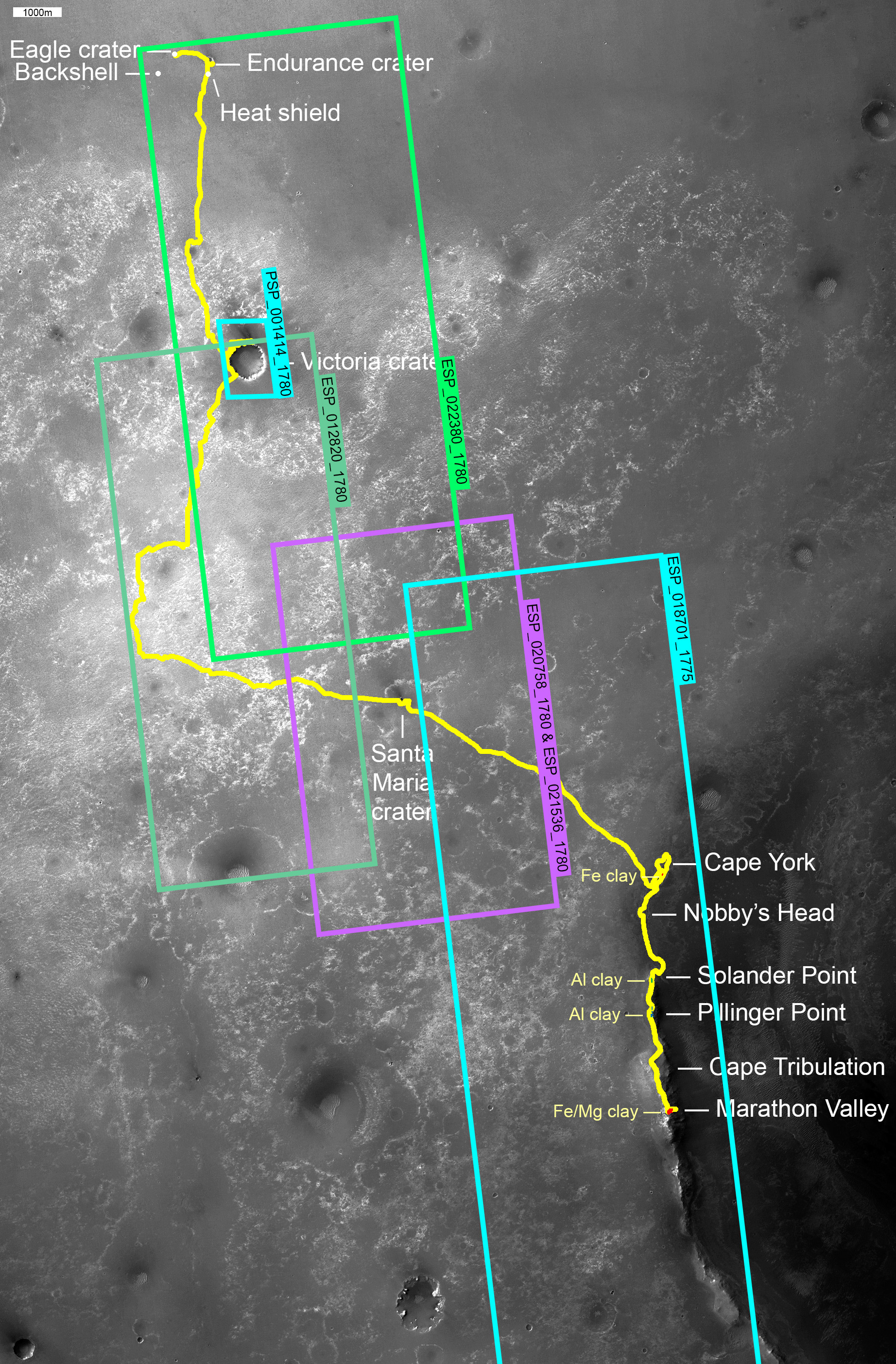
A wider take on the route map -- I finally finished doing for Opportunity what I did for Curiosity a while ago, organizing the collection of HiRISE images covering the traverse.

Very nice, Emily.
Here is an update to sol 4559, driving past Pompy's Tower.
Phil
Click to view attachment
PS Watch this space for a big route map announcement coming soon. Fear not, it's a good announcement, if I can get it to work.
Here is an update to sol 4559, driving past Pompy's Tower.
Phil
Click to view attachment
PS Watch this space for a big route map announcement coming soon. Fear not, it's a good announcement, if I can get it to work.
Sol 4566, a nice drive about 17 m SSE - the location is only approximate until I see more images.
Phil
Click to view attachment
Phil
Click to view attachment
QUOTE (elakdawalla @ Nov 18 2016, 03:34 PM) 
A wider take on the route map -- I finally finished doing for Opportunity what I did for Curiosity a while ago, organizing the collection of HiRISE images covering the traverse.
Great work and excellent article.
Another drive on sol 4568 - moving below the third mound in this area. Very soon it will be possible to drive up the hill between it and the big ridge to the south.
Phil
Click to view attachment
Phil
Click to view attachment
Sol 4570 - and we are going round the bend. So to speak. Turning towards the uphill path. My placename 'SW Ridge' is an imaging target from the time at Spirit Mound, but I'm not sure it is really in the right place.
Phil
Click to view attachment
Phil
Click to view attachment
Another drive uphill on sol 4577, a bit over 11 m.
Phil
Click to view attachment
PS I think the name SW Ridge fits better where I have it now, looking back at when it was used. But if anyone can correct me...
Phil
Click to view attachment
PS I think the name SW Ridge fits better where I have it now, looking back at when it was used. But if anyone can correct me...
A 15 m drive on sol 4580, taking us up the valley. I might be a few metres NW of our actual location, need more images to check it. Also a feature name, Elwood - I don't yet know what it refers to.
Phil
Click to view attachment
Phil
Click to view attachment
Another drive on sol 4582 (plus a correction to the previous drive). Time for a new map base.
Phil
Click to view attachment
Phil
Click to view attachment
Another drive uphill on sol 4584, just fitting on to this map before I change the base. I made several small corrections to match the latest map on the MER website.
Phil
Click to view attachment
Phil
Click to view attachment
This is just a bit of a wider view of the current area, showing also the route shown in the extended mission plan (white line).
Phil
Click to view attachment
Phil
Click to view attachment
Another 30 m on sol 4586, getting up to some nice outcrops of brighter material. There's a rocky bluff just above us, so do we go to the left or right of it? Right is straight up the hill, pretty steep, maybe too steep at one particular spot. Left is south, across a field of small blocks which is probably a recent rockfall deposit, but not as blocky as the one below SW Ridge.
Phil
Click to view attachment
Phil
Click to view attachment
We didn't stay at yesterday's location for two sols, my mistake - so here is an update for sol 4589. A drive of just 7 m directly uphill (west).
Phil
Click to view attachment
Phil
Click to view attachment
ONWARD!!! 
It looks from the map that Oppy is actually going backwards.
Anyone know if this is slippage or an intentional reversal (i.e. to look at the trench)?
It is almost midnight of 4604 in Meridiani. I am hoping that Oppy is making more progress uphill.
Anyone know if this is slippage or an intentional reversal (i.e. to look at the trench)?
It is almost midnight of 4604 in Meridiani. I am hoping that Oppy is making more progress uphill.
The latest PS update says that the 4591 bump was "to check out the rock [Beacon?] and other nearby targets" - no mention of slippage. Given the timing with the holidays I'd guess the trench was intentional, to provide a target for study.
Edit: this weekly update says that there was an embedding on 4589. Seems they're interested in the bright soil revealed.
Edit: this weekly update says that there was an embedding on 4589. Seems they're interested in the bright soil revealed.
Trench or no trench, off we go again. A jog to the northeast to get onto solid ground, a rocky outcrop - leading to a drive on as much rock as possible (I am assuming) around the northern side of Beacon Rock.
Phil
Click to view attachment
Phil
Click to view attachment
... and a not so good drive on sol 4611. Lots of slip by the look of it.
Phil
Click to view attachment
Phil
Click to view attachment
A nice holiday drive for Opportunity, a bit further up the ridge. I think the rover is now at the steepest part of the slope, and getting past this spot might be tricky.
Phil
Click to view attachment
Phil
Click to view attachment
Sol 4618 - no, it wasn't tricky for our sure-footed mountain goat of a rover. Now it should be fairly easy progress into the top of Willamette Valley.
I'm not sure I have the name John Ellison in the right place, or even if 'Hole' should be considered a name. Any advice welcome!
Phil
Click to view attachment
I'm not sure I have the name John Ellison in the right place, or even if 'Hole' should be considered a name. Any advice welcome!
Phil
Click to view attachment
Sol 4622, another 10 m drive and it looks like a clear road ahead to the top of Willamette Valley.
Phil
Click to view attachment
Phil
Click to view attachment
Our intrepid teenager just galloped another 26 m up the slope. Here's an update - the position is only a guess based on reported distance as I don't have the images yet.
Phil
Click to view attachment
Phil
Click to view attachment
And an overview map showing progress so far up the hill. The rover is out of restricted sols and can drive every day now.
Phil
Click to view attachment
Phil
Click to view attachment
Update to sol 4631 - we're finally in that last hollow area near the top of the hill, and it looks like fairly easy going. I was concerned that the summit ridge might be a loose drift.
Phil
Click to view attachment
Phil
Click to view attachment
One more drive to get to the 44 kms mark right? Why not tomorrow for the UNMSF's 12th birthday?
I'm not sure exactly where that will happen.
A closeup for the exit route, sol 4636.
Phil
Click to view attachment
A closeup for the exit route, sol 4636.
Phil
Click to view attachment
OK, Earthlings, if we just take the drive distance and direction reported by Midnight Planets at face value we should be here:
Click to view attachment
(EDIT - replaced with an updated map, better positions)
Right on the rim. Unfortunately the lack of forward-facing images (as I write this) makes it impossible for me to verify that assertion. But I'll make it anyway.
EDIT - I have updated my recent positions using a new map from Larry Crumpler's Field Reports from Mars. That pulls the latest position (still not on his map) down a bit, fitting the new images better.
The name 'York' on the previous map was a cut and paste error, now removed.
Phil
Click to view attachment
(EDIT - replaced with an updated map, better positions)
Right on the rim. Unfortunately the lack of forward-facing images (as I write this) makes it impossible for me to verify that assertion. But I'll make it anyway.
EDIT - I have updated my recent positions using a new map from Larry Crumpler's Field Reports from Mars. That pulls the latest position (still not on his map) down a bit, fitting the new images better.
The name 'York' on the previous map was a cut and paste error, now removed.
Phil
A small move on sol 4635 to position the arm workspace over a little chunk of rock called Boonville.
Phil
Click to view attachment
Phil
Click to view attachment
A while ago I mentioned in this thread to look out for a big announcement concerning Opportunity route maps. Well, it took longer than I expected but finally I can make that announcement.
I have collected a set of maps following the whole path from Eagle crater to the exit from Endeavour, sols 1 to 4600. Well, not quite the exit, but close to it. These are maps from my Mars Atlas (up to sol 3700) and from new work since then, including maps released here. I have assembled them in an ebook which - as of today - is available from the Kobo store. Just go to www.kobo.com and search for my name and you will find it.
It's only maps, apart from a half page introduction. They are best viewed on a tablet, or I suppose a desktop ebook reader. The file is .epub format, which probably can't be read on a Kindle but can on lots of other e-readers. On a tablet the maps can be expanded and scrolled around to follow the path of the rover. No text, no photos, just maps, but I hope it will be a handy guide to the travels of our plucky little rover. And a lot cheaper than my big books. Because the book consists only of images it's quite a big file, so if you want it, be in a place with a good wifi connection!
Of course, now the book is out of date again... by a few sols. I will update the file from time to time, once each year or two. If this works out well I will do Spirit and Curiosity as well, and maybe other topics I can draw on from my vast collection of files.
Phil
A new drive on sol 4664 and a bit of a correction for the last one. EDIT - corrected by someone who would know better than I do - the drive was on sol 4665. I will fix it on the next map.
Phil
Click to view attachment
Phil
Click to view attachment
We had a nice 36 m drive on sol 4670, certainly leaving that mound behind without scrambling up it. When I was teasing Olivier about it I thought we were further SE than we really were - I found it hard to match the surface and HiRISE views of the hillside.
Phil
Click to view attachment
Phil
Click to view attachment
This is a "lo-fi" version of our main content. To view the full version with more information, formatting and images, please click here.