Just a quick update for sol 3349, using the rover's metadata. I will do a better one when more images are available.
Click to view attachment
Full Version: Opportunity Route Map
Pages: 1, 2, 3, 4, 5, 6, 7, 8, 9, 10, 11, 12, 13, 14, 15, 16, 17, 18, 19, 20, 21, 22, 23, 24, 25, 26, 27, 28, 29, 30, 31, 32, 33, 34, 35, 36, 37, 38, 39, 40, 41, 42, 43, 44, 45, 46, 47, 48, 49, 50, 51, 52, 53, 54, 55, 56, 57, 58, 59, 60, 61, 62, 63, 64, 65, 66, 67, 68, 69, 70, 71, 72
Here's the updated map, the "big" version this time, including the current position as of sol 3351 although this last one is still purely based on the rover's metadata. Some of the latest positions have been readjusted based on the navcams.
Click to view attachment
Click to view attachment
Click to view attachment
Click to view attachment
My route map updated with the last drives until sol 3356. I will keep posting updates for the rest of the week but will be on vacation for the next two ones. If anyone wants to take over, please do so.
Click to view attachment
Click to view attachment
Click to view attachment
Click to view attachment
Updated to sol 3362. Thanks to mhoward for his input. I've never known a place as difficult as this to locate sites, but it should be easier when full 360 degree Navcam pans are available.
Phil
Click to view attachment
Phil
Click to view attachment
Thank you for the updates, and you'll indeed get some very good landmarks in just a day or two now. =)
I added a temporary extension to the map until I can get around to a proper job. Update to 3369. Someone forgot to set the parking brake on sol 3364.
Phil
Click to view attachment
Phil
Click to view attachment
QUOTE (Phil Stooke @ Jul 17 2013, 02:25 PM) 
Someone forgot to set the parking brake on sol 3364.
That comment & route map made me wonder where Oppy might be headed..... no-one seems to know....
Click to view attachment
QUOTE (Jaro_in_Montreal @ Jul 17 2013, 09:11 PM)
..... no-one seems to know....
The quote from Larry Crumpler's blog linked in post 331 in the "Heading South..." thread bears repeating.
"Because we have been making good time, we have a couple of sols of margin that we would like to use , there is a desire to do a short side trip to the east to investigate an anomaly detected from orbital remote sensing. This means descending into the crater wall a hundred meters or so before turning south to intercept Solander Point. The anomaly looks texturally different as well as spectrally different. We will see what we see."
Just came back from a (much needed) vacation. Two weeks away from work (but not from UMSF, at least in "lurking mode").
Just would like to say many, many thanks to Phil for keeping this thread alive during this time, and for all others which were also helping on the rover's localization. Still have some things to do here on earth before moving to the martian duty, but I guess tomorrow I will be able to resume that.
Just would like to say many, many thanks to Phil for keeping this thread alive during this time, and for all others which were also helping on the rover's localization. Still have some things to do here on earth before moving to the martian duty, but I guess tomorrow I will be able to resume that.
Ok, done.
Here's the route map, and in KML format too. Updated to sol 3374.
Click to view attachment
Click to view attachment
Here's the route map, and in KML format too. Updated to sol 3374.
Click to view attachment
Click to view attachment
I have updated the map including this last drive on sol 3384 and "Black Shoulder" too. Here's a crop of it and the GE version too.
Click to view attachment
Click to view attachment
Click to view attachment
Click to view attachment
I'm posting the big picture covering both Cape York and Solander Point once again, probably the last time because I plan to reduce it and focus only on Solander Point. This one is good up to sol 3410.
Click to view attachment
Click to view attachment
Click to view attachment
Click to view attachment
Here's a map crop centered at Solander Point and good up to sol 3426. And the version for Google Earth too, as usual.
Click to view attachment
Click to view attachment
Click to view attachment
Click to view attachment
A quick update, good up to sol 3441, but I still have to double-check the last two positions against the navcam mosaics.
Click to view attachment
Click to view attachment
Click to view attachment
Click to view attachment
Time for another update, with the latest data from sol 3451.
Click to view attachment
Click to view attachment
Click to view attachment
Click to view attachment
Thanks as ever to Tesheiner for updating this map so faithfully.
I was just putting this together for my book and thought I would share it. I still have a few names to add, I think, and a scale. The white squares are the main science stops - a little refinement I have just been adding retroactively to maps for all rovers in the atlas.
Phil
Click to view attachment
Wow! Please share those more often, Phil. 
I second that! 
Amazing work you guys do. A request for one different view as we proceed up the hill. Could someone take a far off ground level view of Solander Point and from time to time show the general location on the side of that hill? All those outcrops are looking very alike and while the overheads are wonderful, I'm just not getting a feel for how much up is involved in each move.
I think that Midnight Planets can do exactly that.
It can certainly help visualize where the rover is, but the raw tracking data is not precise enough to accurately place the rover from a significant distance (or sometimes, as you know, even from a moderate distance). And I haven't had time to do my own corrections of the tracking data so far.
Art, you may want to check this out - second image down on this page.
Phil
http://nmnaturalhistory.org/rover-field-re...-from-mars.html
Phil
http://nmnaturalhistory.org/rover-field-re...-from-mars.html
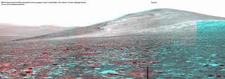
Here's where I think "Kangaroo Paw" (Sol 3459) is on the Sol 3366 long baseline stereo mosaic. This is based on a whole lot of looking around, but I could easily be wrong... corrections welcome.
Ooh, neat, and thanks for doing it in 3D!
I think that's right - there are three rocky spurs - tiny outcrops - here, seen in Navcams, and we can see them here in your anaglyph.
Phil
Phil
That's very helpful. I remember many such virtual views from a distance being posted when we were at Victoria crater. I think it's time to resurrect the genre. We're on a convex slope here so the view from the rover is limited and not easily related to the wider context.
Looks like a good position. Thanks for doing this.
Total stab-in-the-dark attempt to relate the positions in the last two perspectives in Phil's link and mhoward's post.
Click to view attachment
Click to view attachment
QUOTE (ngunn @ Oct 17 2013, 10:55 PM)
That's very helpful. I remember many such virtual views from a distance being posted when we were at Victoria crater. I think it's time to resurrect the genre.
Yeah, this type of localization really helps.
The best example of this if the famous 'alan is lost' Spirit route maps of the inner basin:
e.g.
Click to view attachment
http://www.unmannedspaceflight.com/index.p...ost&p=44626
Thank you all so much. Exactly what I was hoping for.
Here's an updated map where I took some time to revise a few of the previous positions starting at sol 3437.
Click to view attachment
Click to view attachment
BTW, I'm not so confident about the location of our current site (Kangaroo Paw) on the map and any help is welcome.
Click to view attachment
Click to view attachment
Click to view attachment
BTW, I'm not so confident about the location of our current site (Kangaroo Paw) on the map and any help is welcome.
Click to view attachment
You are exactly on target!
Phil
Phil
Here's an update on my version of the Solander map. Details, including locations of named features, are always subject to further refinement.
Phil
Click to view attachment
Phil
Click to view attachment
I haven't taken time to do this 'properly', but here's where I think she is on sol 3485 on the long baseline anaglyph.
Sol3366LongBaselineAnaglyphWithPositions_3485 on Flickr
Sol3366LongBaselineAnaglyphWithPositions_3485 on Flickr
My location is very close to that. Here I combine the HiRISE view (south up, borrowed from Tim Parker's map at the MER website) and a vertigo-inducing stretch of the red channel from Mike's anaglyph. The red dot shows my current position. Using this comparison it's easy to match the HiRISE with the surface view.
Phil
Click to view attachment
Phil
Click to view attachment
Looks good. I'd just add that based on this map from Crumpler and Phil's location I think you could argue that we've now basically arrived at the "winter outcrops".
This is a "lo-fi" version of our main content. To view the full version with more information, formatting and images, please click here.