
Full Version: Opportunity Route Map
Pages: 1, 2, 3, 4, 5, 6, 7, 8, 9, 10, 11, 12, 13, 14, 15, 16, 17, 18, 19, 20, 21, 22, 23, 24, 25, 26, 27, 28, 29, 30, 31, 32, 33, 34, 35, 36, 37, 38, 39, 40, 41, 42, 43, 44, 45, 46, 47, 48, 49, 50, 51, 52, 53, 54, 55, 56, 57, 58, 59, 60, 61, 62, 63, 64, 65, 66, 67, 68, 69, 70, 71, 72
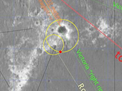
Here's a nice map (a bit old though). Not sure if you guys have seen this thing or not...
No, we haven't! ...and it's a keeper. Very intriguing on a number of levels. Many thanks, Pando.
edit: I forgot to say, aside from the fascinating future route map, I noticed the original plan was to take an early diagonal toward Beagle as many here were guessing before we saw the dunes from the rover's eyes. But more fascinating to me are the arrows pointing to this new Halfpipe formation right around the Hell of a View location. I'm going back to see if I can figure out what that is all about.
Lastly, if you can put your fingers on any other adjoining pieces of that map, some of us would be very appreciative.
Very intriguing on a number of levels. Many thanks, Pando.edit: I forgot to say, aside from the fascinating future route map, I noticed the original plan was to take an early diagonal toward Beagle as many here were guessing before we saw the dunes from the rover's eyes. But more fascinating to me are the arrows pointing to this new Halfpipe formation right around the Hell of a View location. I'm going back to see if I can figure out what that is all about.
Lastly, if you can put your fingers on any other adjoining pieces of that map, some of us would be very appreciative.
QUOTE (Pando @ Aug 11 2006, 04:45 PM) 
Here's a nice map (a bit old though). Not sure if you guys have seen this thing or not...
Have we been digging in the trash bin out behind JPL?
QUOTE (CosmicRocker @ Aug 12 2006, 04:05 AM)
But more fascinating to me are the arrows pointing to this new Halfpipe formation right around the Hell of a View location.
Absolutely! This suggests that we encountered a new stratigraphic horizon at Payson, where the term first appeared. But are we above or below the Burns Formation?
Any other crumbs lying around JPL's trashbin, Pando??

Good to see you on the hunt, aldo12xu. This new formation name made me dig back into previous panoramas. Thank god for MMB.
Here are the clues that I had to start with.
* Pando's map
* According to my notes from the LPSC this spring, Grotzinger and others mentioned something called the "Mogollon Contact," which was the highest contact mentioned so far, but they said very little else about it. It is supposed to be above Burns and it's contacts.
* Back when they were at Mogollon they used the term "halfpipe" to describe the low road they took below the outcrop ledge.
* So, we have a contact (possibly between two geological formations) named the Mogollon contact, and the named geomorphic feature called halfpipe that they drove through in the vicinity.
* Phil's very nicely annotated map.
* later, (around Hell of a View) they are pointing to other ledges and the Halfpipe formation on Pando's map.
I went back to Mogollon and and later sites to look around. In all of them there is a ledge nearby, and in some of them, there are also dark cobbles about. It's a pretty convincing geomorphic layer. It is late, so I am passing the ball to the nearest person...
This new formation name made me dig back into previous panoramas. Thank god for MMB.Here are the clues that I had to start with.
* Pando's map
* According to my notes from the LPSC this spring, Grotzinger and others mentioned something called the "Mogollon Contact," which was the highest contact mentioned so far, but they said very little else about it. It is supposed to be above Burns and it's contacts.
* Back when they were at Mogollon they used the term "halfpipe" to describe the low road they took below the outcrop ledge.
* So, we have a contact (possibly between two geological formations) named the Mogollon contact, and the named geomorphic feature called halfpipe that they drove through in the vicinity.
* Phil's very nicely annotated map.
* later, (around Hell of a View) they are pointing to other ledges and the Halfpipe formation on Pando's map.
I went back to Mogollon and and later sites to look around. In all of them there is a ledge nearby, and in some of them, there are also dark cobbles about. It's a pretty convincing geomorphic layer. It is late, so I am passing the ball to the nearest person...
That image is from the S11 phase of MGS ops, so it JUST missed the last data release, but will be in the next one in October.
Doug
Doug
Thanks, Pando. I thought this was one of Phil's old maps and didn't look too closely at it. Teach me to gloss over anything...
Phew!! As Tom notes, there lot of interesting puzzle pieces on this map. My early hunch about the dark bluff at Payson being special was evidently correct since the Halfpipe Formation was being tagged many Sols down the road. Of interest: this unit is noted at what we at UMSF called "The Sinkhole" and two other locations to the NE and seems to me to indicate areas of dark sand/cobbles and/or a bluff-forming unit. I wished that we had spent more time at Payson and the "Sinkhole", but let's look at what Oppy gathered at those locations.
Skaelland Crater is just West of Purgatory II. Is it special or just a waypoint on the traverse?
At Beagle and Victoria's "Ejecta Blanket": ah ha, those "chisholm hillocks" are noted as "Outcrop/annulus Contacts". Those eroded craters are noted as Degraded Craters and several of the newer craters North of Victoria are noted as Fresh Craters. We may expect visits to those features.
Let's dig around and see what these clues might mean.
--Bill
907 looks like roughly a twenty meter drive almost due south. I put Opportunity right past the end of that crescent-shaped finger of outcrop. I put a dot on a piece of the map in case anyone wants to see the new location. Looking SSW, I see a small crater a little over 100 meters ahead. I wonder if they are heading there to look into the hole in the apron.
Click to view attachment
Click to view attachment
...and here's my version.
Phil
Click to view attachment
(PS I'm applying the name 'Beagle Highway' to the whole strip of outcrop here, not just the stretch between Jesse Chisholm and Beagle)
Phil
Click to view attachment
(PS I'm applying the name 'Beagle Highway' to the whole strip of outcrop here, not just the stretch between Jesse Chisholm and Beagle)
Damn! You don't know how relieved I am to notice that I correctly spotted it. I think there may be more difficult mapping after this leg, though.
QUOTE (CosmicRocker @ Aug 13 2006, 11:35 PM)
Damn! You don't know how relieved I am to notice that I correctly spotted it. I think there may be more difficult mapping after this leg, though.
I think it is so. Now, on the Annulus of Victoria, there are fewer features (bolders, outcrops, big ripples, or whatever some big enough piece that is able to identify by the MOC picture.
The ripples is becoming smoother. The recent Oppy pictures have shown that the sand is becoming even more compact, no loose and Oppy was able to cross ripples easier. See the following track picture http://marsrovers.jpl.nasa.gov/gallery/all...AP1214L0M1.HTML
Rodolfo
QUOTE (RNeuhaus @ Aug 14 2006, 06:41 PM)
The ripples is becoming smoother. The recent Oppy pictures have shown that the sand is becoming even
Rodolfo
Rodolfo
Yes. and it's also encouraging that the ripples seem so small that Oppy, even if it happens to cross one at an unfortunate angle, it will easily always stand with at least one pair of wheels on the firm ground between the ripples ... so I expect some long distance drives soon
Worst case, we ought to be able to triangulate off of the Twin Peaks and Hawking Rock throughout much of the route. Later there should be ejecta blocks from Epsilon that will be helpful, and I'd expect some Vicky features as well.
In fact, if I were driving, the route I would choose would drive directly to Hawking, then skirt Epsilon and Zeta (quite possibly driving onto one rim or the other to take a higher perspective view towards Victoria), followed by the final drive up to Vicky's rim. This simplifies the heck out of the navigation, plus collects science on the only targets of interest along the way. Of course, the rover drivers have surprised me before
In fact, if I were driving, the route I would choose would drive directly to Hawking, then skirt Epsilon and Zeta (quite possibly driving onto one rim or the other to take a higher perspective view towards Victoria), followed by the final drive up to Vicky's rim. This simplifies the heck out of the navigation, plus collects science on the only targets of interest along the way. Of course, the rover drivers have surprised me before
Navigation on the ejecta blanket shouldn't be a problem. Once we get out of this transitional zone the surface becomes flat as a pancake but still has some relief. Attached is the "really nice but annotated" image (PIA08447), cropped and properly contrast-tweaked which shows details on the blanket.
--Bill
--Bill
It looks as if my Sol 907 location was based on mid-drive images, and Opportunity moved further south than I had shown it. I'll correct it after the next move.
I see a substantial discrepancy between the maps posted here earlier and the recent Tim Parker map posted by Pando, in the sol 800-810 period. I'll have to look back at panoramas from that period - tomorrow! - to try to resolve it.
Phil
I see a substantial discrepancy between the maps posted here earlier and the recent Tim Parker map posted by Pando, in the sol 800-810 period. I'll have to look back at panoramas from that period - tomorrow! - to try to resolve it.
Phil
nah, it can't be too significant. There are only 5 or 6 wheel revolutions after leaving the outcrop and deploying the arm.
It's about this much...
http://marsrovers.jpl.nasa.gov/gallery/all...unity_f907.html
On my map the 907 point was right at the south end of that little strip of outcrop. It should have gone a bit further south. Not much, I know, but enough to matter.
Phil
http://marsrovers.jpl.nasa.gov/gallery/all...unity_f907.html
On my map the 907 point was right at the south end of that little strip of outcrop. It should have gone a bit further south. Not much, I know, but enough to matter.
Phil
estimated sol 909 position:
This is based on the sol 908 Navcam image measurment of 32 +/- 2 meters to the south rim of Beagle less the apparent 5 meter movement north on sol 909 -- and a sol 909 Navcam measurment of 16.6 +/- 0.5 meters to a rock on the edge of Beagle Highway outcrop to the west.
The north movement was a surprise. I measured a sol 908 navcam southward rock distance of 13.7 +/- 0.4 and a sol 909 pancam distance of 18.8 +/- 0.2.
I am mystified by this movement.
They said they wanted to look at one of the banded drifts, and this might be the last chance.
Phil
Phil
Perhaps characterise the dune material in this region before spending a month or two driving on it toward Vic.
And, just speculating, perhaps whilst sat here with the arm out, they might do the switch to the new flight software?
Doug
And, just speculating, perhaps whilst sat here with the arm out, they might do the switch to the new flight software?
Doug
QUOTE (djellison @ Aug 15 2006, 02:30 PM)
Perhaps characterise the dune material in this region before spending a month or two driving on it toward Vic.
Sounds reasonable to me. I'm guessing this is our first contact with the annulus material so they want to check it out. Those of us who were dreaming of a rapid transit toward Victoria will probably need to adjust our expectations somewhat, but once we lay the groundwork here I'm sure we'll be speeding along.
Here's a equirectangular projection of the three Navcam frames in case Phil or someone wants to turn it into a polar for mapping purposes. North is at center.
QUOTE (Phil Stooke @ Aug 15 2006, 10:21 AM)
They said they wanted to look at one of the banded drifts, and this might be the last chance.
Phil
Phil
Yes, that seems to be the plan. Closer measurments of a small rock in the closeup Navcams of this area on sols 908 and 909 showed a movement of 1.86 +/- 0.03 meters towards this area.
QUOTE (mhoward @ Aug 15 2006, 03:03 PM)
Here's a equirectangular projection of the three Navcam frames in case Phil or someone wants to turn it into a polar for mapping purposes. North is at center.
Vertical+Polar projections.
Click to view attachmentClick to view attachment
(Michael, if you regularly publish these equirectangular projections, I will be happy to reproject them!
)
QUOTE (dilo @ Aug 15 2006, 04:05 PM)
(Michael, if you regularly publish these equirectangular projections, I will be happy to reproject them! )
)Sure thing. They're pretty easy for me to produce now, and they should be fairly accurate as I'm feeding the actual camera pointing information to PTGui.
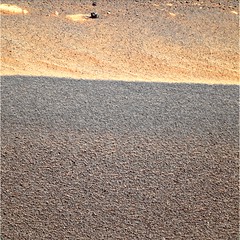
QUOTE (hortonheardawho @ Aug 15 2006, 10:26 AM)
Yes, that seems to be the plan. Closer measurments of a small rock in the closeup Navcams of this area on sols 908 and 909 showed a movement to 1.86 +/- 0.03 meters towards this area.
Thanks hortonheardawho's picture.
That picture has brough me the attention. Its minor-surface is nothing flat but it presents small underlines and the color of every grain is rather homogeneous except to few dark points (another kind of pulverized rock). It looked like that surface has undergone by very thin or very small humidity.
Rodolfo
QUOTE (algorimancer @ Aug 14 2006, 08:05 PM)
Worst case, we ought to be able to triangulate off of the Twin Peaks and Hawking Rock throughout much of the route. Later there should be ejecta blocks from Epsilon that will be helpful, and I'd expect some Vicky features as well.
I was thinking on a similar approach using Delta and Epsilon as references; I think more the features better the triangulation.
But I would use this method as a way to periodically adjust the route. I think for most of the way on this last part of the route I'll use the rover's position data from the pancam data tracking web to plot the path and from time to time (e.g. each 200m) do a triangulation to see if such path needs to be corrected.
Ok, here we go again. My route map, updated to sol 912.
Click to view attachment
PS: This latest position is derived from a 55m drive on a heading about 14º to the left (east) of "Gamma".
Click to view attachment
PS: This latest position is derived from a 55m drive on a heading about 14º to the left (east) of "Gamma".
QUOTE (Tesheiner @ Aug 18 2006, 03:53 PM)
Ok, here we go again. My route map, updated to sol 912.
Click to view attachment
PS: This latest position is derived from a 55m drive on a heading about 14º to the left (east) of "Gamma".
Click to view attachment
PS: This latest position is derived from a 55m drive on a heading about 14º to the left (east) of "Gamma".
Love the labeling
I think that sometime in the next few days we ought to be able to firmly tie Hawking Rock to a feature on the C-Proto image, I have strong suspicions already. I noticed today that it is already spanning about 3 pixels in height from the current position. Seems big for a meteorite, but not inconceivable. Could be the Monolith I suppose, but seems too pointy
QUOTE (algorimancer @ Aug 18 2006, 11:18 PM)
I think that sometime in the next few days we ought to be able to firmly tie Hawking Rock to a feature on the C-Proto image
You should be quick or Oppy will run by that rock before we can locate it!

Updated route map for sol 914.
Click to view attachment
QUOTE (Tesheiner @ Aug 20 2006, 03:07 PM)
You should be quick or Oppy will run by that rock before we can locate it!
What's the Martian for Va Va Voom?
QUOTE (Tesheiner @ Aug 20 2006, 04:07 PM)
Updated route map for sol 914.
Oppy is closing up to the center of the image very quickly. I'm looking forward to see your route where the center of the image will be the center of Victoria. BTW, will you also keep the context image? Just wondering, I'll know very soon for sure
Here is the latest version of my total route map. It consists of 15 squares, each 500 m across, with a grid (based on a map-projected MOC image) at 100 m spacing. The origin of the grid is the lander. It incorporates numerous corrections to versions I have posted before. Each square (at full size) will be a separate map in a future project.
Phil
Click to view attachment
Phil
Click to view attachment
Helvick: "What's the Martian for Va Va Voom?"
Hubba Hubba, I think.
Phil
Hubba Hubba, I think.
Phil
A drive to Vicky via Epsilon will help us keep our bearings and will give us a peek at that ancient degraded crater too. Epsilon crater here we come!
QUOTE (Phil Stooke @ Aug 20 2006, 08:04 PM)
... with a grid (based on a map-projected MOC image) at 100 m spacing.
Phil
Phil
I counted the grids
: we're (about) 6300 m south of Eagle-Endurance. I know you know, but...
QUOTE (Phil Stooke @ Aug 20 2006, 01:04 PM)
Here is the latest version of my total route map. It consists of 15 squares, each 500 m across, with a grid (based on a map-projected MOC image) at 100 m spacing. The origin of the grid is the lander. It incorporates numerous corrections to versions I have posted before. Each square (at full size) will be a separate map in a future project.
Phil
Click to view attachment
Phil
Click to view attachment
Anyone else notice that the Twin Peaks (crater rim near 100 degrees azimuth) has ceased to be visible since moving onto the Victoria ejecta? This blows away all those notions I'd had about using them as a triangulation and calibration reference. I'd assumed this would occur eventually, but figured we'd be much closer to Victoria before it happened.
Phil, I notice that since entering the ejecta terrain there is a noticeable divergence between your map and Tesheiner's map (nice to see all of yours in one place). Presumably the dearth of landmarks is presenting the anticipated challenge to navigation. I'm curious as to what references the two of you are using at this point to derive your positions. I'm assuming that Beagle, Epsilon, and Delta are the most obvious targets, but of course they're all a bit ambiguous from this far away, so what I'm particularly wondering is whether there's enough detail in the MGS images to identify the particular dunes visible around Oppy.
QUOTE (Tesheiner @ Aug 20 2006, 09:07 AM)
You should be quick or Oppy will run by that rock before we can locate it!
At the moment, both your's and Phil's route maps suggest that Oppy is pretty-near aiming straight for Hawking rock, so it looks like we'll get to know it much better before long. The real trick will be to fix it to a nice unambiguous position on the route map, much as when we first hit Jesse Chisolm (West Hillock). Anyone know whether there is an ongoing campaign to have MGS periodically the rovers with c-proto images? It's been a long time since the last one.
QUOTE (algorimancer @ Aug 20 2006, 11:13 PM)
Anyone know whether there is an ongoing campaign to have MGS periodically the rovers with c-proto images? It's been a long time since the last one.
Sorry I have no clue. I just want to remind that Doug once said that MRO's images will not surpass MGS c-proto's. So, we'd better get some more soon! In another end and IIRC, I red a long time ago that they were expecting MRO's pictures to help explore VC. Some contradictions there.
QUOTE (climber @ Aug 20 2006, 10:23 PM)
Sorry I have no clue. I just want to remind that Doug once said that MRO's images will not surpass MGS c-proto's.
Nuhhuh.....I think they will
MC doesn't think the difference will be much, but I think we'll be suprised, with twice the number of pixels on the ground downtrack, and 6 times as many across track, and a sort of 'colour' into the mix. OK - so it wont resolve 25cm/pixel (but the test images were damned impressive).....but even if it's only 50cm/pix - that's three on the ground for every CPROTO pixel.Doug
QUOTE
Anyone else notice that the Twin Peaks (crater rim near 100 degrees azimuth) has ceased to be visible since moving onto the Victoria ejecta?
Yes, I've noticed that things (appearances, actually) change quite rapidly on the Victoria ejecta apron. This is a major topographic feature, elevation-wise, but is very wide and smooth so you don't realize how tall it is. Beagle is sinking below the horizon, and look at the detail we're starting to see on the "Epsilon" rim.
I've not been able to guess at "Hawking Rock" on the MOC image, though.
--Bill
After only 2 days of driving since leaving Beagle, we're almost 1/4 of the way from Beagle to Victoria.
"Phil, I notice that since entering the ejecta terrain there is a noticeable divergence between your map and Tesheiner's map"
Don't pay too much attention to exact locations - they will evolve a bit over time as we get exact distances and more looks back. I frequently go back and edit my map. I posted the big one because I've made numerous changes across the etched terrain.
Phil
Don't pay too much attention to exact locations - they will evolve a bit over time as we get exact distances and more looks back. I frequently go back and edit my map. I posted the big one because I've made numerous changes across the etched terrain.
Phil
Best guess at the location of Hawking Rock:
http://www.clarkandersen.com/R1500822_NWVi...mpp_Hawking.PNG
(big file, about 4.5 Megs, uncompressed)
This is a rescaled version of image R1500822 (the map projected version), scaled to 0.5 meters per pixel. It seems in reasonable agreement with the azimuths as reported by the AlgorimancerPG application.
I managed to find a single image showing Hawking from Sol 887, combined with another from Sol 904, yielding about an 80 meter baseline. Performed wide baseline photogrammetry to Hawking to yield the single-pixel hilighted positions. Results of 4 calculations are shown (single colored pixels). I would lean towards the lower two "corrected azimuth" versions (w/corrections referenced to the Twin Peaks yielding +0.33637284 azimuth degrees for Sol 887 and +0.086453315 azimuth degrees for Sol 904 (azimuth correction will be available in APG 3.3, not yet posted). I would allow a bit of leeway in the east-west dimension to allow for error in the image projection, but feel pretty confident about the north-south position (to within a few meters). Bearing in mind that illumination is from the left in this image, several features immediately east and west of the lower two pixel positions may in fact be Hawking, but for the moment I'm leaning towards the dark E-W linear feature immediately to the left (west) of the lower pixel pair, which terminates at the pixels, as Hawking + shadow. In ImageJ, with the image processed to apply a shadow illuminated from the Northwest, that feature stands out nicely.
It would be interesting to look at azimuths to Hawking from more recent Oppy positions, but for now there is some fuzziness in those positions, and no good horizon reference to calibrate the azimuth.
After reading the planetary.org report about MER, I have found an phrase which Arvidson is saying that the MER will climb onto the annulus of Victoria and drive across the northwest portion of Victoria. That place is close to Beacon at near rim.
The extracted article.
While the discussions and debates about which direction to go and what to examine up close are ongoing, there is a general plan, Arvidson said. "Beagle crater features ejecta rays [areas of ejecta that look like rays in the orbital images], so we'll explore some of those first, then we'll climb onto the ejecta apron or annulus of Victoria and drive across toward the northwest portion of Victoria. We want to characterize the broad, dark apron [the Annulus] that extends out around the rim of Victoria, because it's very peculiar, very homogenous when seen from orbit, and we're not exactly sure what it is." Nor do they know what it will take to cross it.
Rodolfo
QUOTE (algorimancer @ Aug 20 2006, 09:47 PM)
Best guess at the location of Hawking Rock:
http://www.clarkandersen.com/R1500822_NWVi...mpp_Hawking.PNG
(big file, about 4.5 Megs, uncompressed)
http://www.clarkandersen.com/R1500822_NWVi...mpp_Hawking.PNG
(big file, about 4.5 Megs, uncompressed)
Just a side note, Irfanview can compress (losslessly) PNG files quite well. Get the Plugins pack and you can use PNGOut, which can really compress PNG files. I ran your file there through Irfanview with PNGOut, and it's down to 2,684,928 bytes.
And now back to your regularly scheduled thread....
QUOTE (algorimancer @ Aug 20 2006, 02:13 PM)
Anyone know whether there is an ongoing campaign to have MGS periodically the rovers with c-proto images?
For what purpose? We know where the rover is, and it's hard to improve on s11-471 for route planning.
QUOTE (djellison @ Aug 20 2006, 02:40 PM)
MC doesn't think the difference will be much, but I think we'll be suprised, with twice the number of pixels on the ground downtrack, and 6 times as many across track...
Not sure what people are expecting. I doubt that the rovers will be resolved as unambiguous objects. I think the images will be improved somewhat over CPROTOs. Having more coverage will be an improvement, of course. As I have said before, the real improvement is in SNR, but it's harder to judge what improved SNR will look like. There wasn't much overlap between MOC images and the HiRISE test images, so we'll have to wait some more to see.
I'm a little late, Phil, but your composite route map is quite nice. And I can remember wondering if we'd reach Endurance Crater!
QUOTE (algorimancer @ Aug 20 2006, 11:06 PM)
I'm curious as to what references the two of you are using at this point to derive your positions. I'm assuming that Beagle, Epsilon, and Delta are the most obvious targets, but of course they're all a bit ambiguous from this far away, so what I'm particularly wondering is whether there's enough detail in the MGS images to identify the particular dunes visible around Oppy.
Given the absolute lack of outcrops here on the apron it's almost impossible to (at least to me) match ground vs. orbital images like while driving on the etched terrain.
For sol 912 drive there were some rocks visible on both pre-drive (sol 909 pancams) and post-drive (sol 912 navcams) images so I just calculated the driving distance using APG. For the driving heading, as "Delta" was visible on the pancams, I used something like "X degrees left of Delta".
For sol 914 drive I didn't calculate anything; just used the rover's position info obtained from the pancam data tracking. I plan to continue using it while we continue on site-id 75xx, if you know what I mean.
As I said before this approach accumulates errors so from time to time a sort of correction/adjustment should be made using a different method. Since it looks like they are heading the rover to that ramp at the end of my "hypotetical route", I'll wait until we are very near to "Epsilon" and then will try to pinpoint the rover's position using that crater as a reference. If I succeed, I'll then update previous positions (since sol 912) to match with this last measurement.
This is a "lo-fi" version of our main content. To view the full version with more information, formatting and images, please click here.