Finally drove away from Pahrump Hills on sol 923. Wheel tracks sure are piling up at the end of the drive -- there seems to have been quite a bit of slip.
[admin note: I was going to start a new thread for this, but realized our thread naming may be a bit out of whack because we're really not journeying to Mt Sharp anymore, are we? We'll discuss it with admins and I'll move/rename posts when we figure out our naming schema.]
QUOTE (elakdawalla @ Mar 12 2015, 08:38 PM) 
we're really not journeying to Mt Sharp anymore, are we?
Isn't 'Mount Sharp' essentially the name of a topographic feature rather than a geologic one?. We may have arrived at rocks that are from the same unit as the base of the mountain but we certainly haven't arrived at the mountain, so I'd say the team were stretching a point to make a point (with good reason) when they announced the 'arrival' and that the thread title's fine.
I agree with ngunn that it's reasonable to say we're still "journeying to Mt Sharp". But the precise boundary of the topographic feature is not well defined, so at some (somewhat arbitrary) point in the future some moderator will have to put their foot down and say "we've arrived".
Maybe after passing the dune fields would be as good a point as any in the meantime? It could be titled 'final approach', or 'ascent beginning'?
http://www.midnightplanets.com/web/MSL/ima...CAM00277M_.html
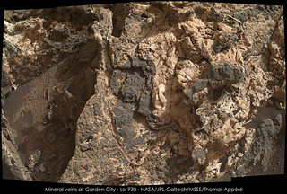
<sings> You're so vein, you prob'ly think this image is of you... <backtoprose>
Yes, vein alert! Very interesting area.
Phil
<sings> You're so vein, you prob'ly think this image is of you... <backtoprose>
Yes, vein alert! Very interesting area.
Phil
Well, according to the mission, we arrived at Mount Sharp as we approached Pahrump Hills, and the rocks we're driving on now are basal to Mount Sharp. But I won't rename the old thread.
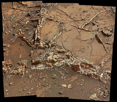
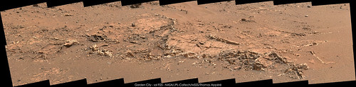
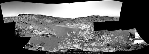
We've driven onto some rocks with some pretty interesting-looking veins:
We've driven onto some rocks with some pretty interesting-looking veins:
I had a brief gasp  when I read "we're not journeying to Mt. Sharp anymore, are we?" -- I wondered if plans to climb after adequate science has occurred at the base had changed. ack, I'm still the kid in the back seat who wants the panoramic view and to see Curiosity hold the altitude title.
when I read "we're not journeying to Mt. Sharp anymore, are we?" -- I wondered if plans to climb after adequate science has occurred at the base had changed. ack, I'm still the kid in the back seat who wants the panoramic view and to see Curiosity hold the altitude title.
 (
(QUOTE (elakdawalla @ Mar 13 2015, 04:38 AM)
...sol 923 Wheel tracks sure are piling up at the end of the drive -- there seems to have been quite a bit of slip.
I believe that Joe's drive log derives drive distance on wheel rotation data. If that is still the case, then we also appear to have had significant wheel slip during the sol 924 drive. JPL issued a point to point distance of 6.13 meters, Joe's page indicates >20m, this could be corruption in the NAIF data, or slip.
The rear pointing NavCam images of the drive on 624 are only down as thumbnails so far, but the wheel track in one of those thumbs looks similar to the deep tracks on the 923 drive. Joe's speed plot for that drive has some really interesting sharp fluctuations in elevation that don't seem to reflect the path, could this be recording the wheels digging in a little until forward progress was made?
QUOTE (PaulH51 @ Mar 14 2015, 04:29 PM)
this could be corruption in the NAIF data, or slip.
NAIF reports raw rover motion ( thus not accounting for slip ) at first until it's bundle adjusted and then it'll be normalized back to the 6m distance as I understand it.
YES! Looks like we are going to take a look at all those veins
http://mars.jpl.nasa.gov/msl/multimedia/ra...26.565191980773
http://mars.jpl.nasa.gov/msl/multimedia/ra...26.565191980773
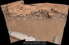
What amazing veins. I'm irresistibly drawn to the old description of the discovery of gold in the Klondike:
"gold lying thick between flaky slabs of rock like cheese in a sandwich"
Phil (reporting from LPSC)
"gold lying thick between flaky slabs of rock like cheese in a sandwich"
Phil (reporting from LPSC)
Don't underestimate the PR value of a gold discovery...
We may be here a while  wow
wow
wow
Wow indeed; that's paydirt (if we're still talking in terms of gold)!
Extraordinary stuff!
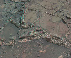
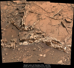
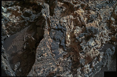
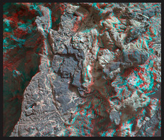
must be trying to steal the limelight from Oppy.. sol926 anaglyph .. what happened here?
Click to view attachment Click to view attachment
Click to view attachment Click to view attachment
so much going on here, had to revisit the area to the left of above.. and portion in xeye form
Click to view attachment Click to view attachment
Click to view attachment Click to view attachment
Visible on the lower right of that last anaglyph rendering is a dimensional "bubble" of sorts that certainly has a hollowed aspect to it. And those boxy segments remind me of overhead views of Pueblo Bonito in New Mexico (http://arch.ced.berkeley.edu/kap/gallery/gal151.html). All around, this is an amazing place to be. And this is an amazing time to be witnessing all these outstanding and previously unseen views of so many distant worlds.
Absolutely spectacular, surely to be one of the highlights of the entire mission.
Speaking as a COMPLETE amateur, this looks to me like extraordinarily powerful evidence of hydrothermal activity; finding silica would presumably clinch that interpretation.
Speaking as a COMPLETE amateur, this looks to me like extraordinarily powerful evidence of hydrothermal activity; finding silica would presumably clinch that interpretation.
Our mosaic and anaglyph of this amazing angle!
and sol 926 mosaic:
and sol 926 mosaic:
QUOTE (nprev @ Mar 17 2015, 03:42 AM)
... this looks to me like extraordinarily powerful evidence of hydrothermal activity; finding silica would presumably clinch that interpretation.
I wonder, whether the dark phase of the veins are (enriched in) hematite or other ores, and whether there may be a connection to Hematite Ridge, interpreting the veins as clastic dikes filling fractures with liquids of a later epoch, and precipitating minerals.
May be resolved later with data from younger layers.
Short-term I'm hoping for - almost expecting - interesting elemental enrichments in the veins, and possible detection of new types of minerals (for Mars).
Although I'm unsure, whether a new drilling will be approved so shortly after the previous drilling.
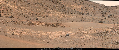
My take on the MastCam-R view of Garden City on Sol 924 (Raw)
Click to view attachment LINK on Flickr
Click to view attachment LINK on Flickr
Interesting -- y'all remember those things Curiosity came across early on, that looked like popped mud bubbles that had frozen into stone?
Looks to me like this formation shows one of those bubbles as an erosional remnant in the uppermost layers of what has most effectively resisted erosion, circled in red in the attached detail.
I also see a lot of other little circular-to-spherical features in the remnant formation, here. Some might be the remains of small impacts, but others might well be the final remains of other of these "popped bubble" formations.
-the other Doug
Click to view attachment
Here is my take on stitching pictures of this amazing place.
Sol 924:
Sol 925:

Sol 926:
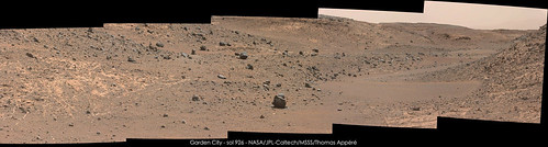
Sol 924:
Sol 925:
Sol 926:
The shape, orientation, and geometry of these fractures reminds me of terrestrial examples of seal failures due to hydrofracturing via overpressure. This is also supported by the observations that they occur in a rather thick massive to laminated mudstone interval and terminate in the overlying more permeable coarser-grained strata.
For the interested, this a nice accessible review article on the subject:
Effects of mechanical layering on hydrofracture emplacement and fluid transport in reservoirs
For those less curious, here is a link to a nice photo from the article of the phenomena:
Hydrofractured Mercia Mudstone
For those in the UK, the classic exposures at Kilve and Watchet in Somerset are worth a pilgrimage to see these phenomena in incredible beach cliff and wave-cut terrace exposures. Check a tide chart, if you do though!
What a beautiful rock!!!

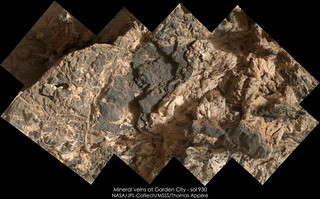
Sol 930, some processing:

and anaglyph
and anaglyph
Outstanding work Elizabeth.
The Garden City mineral veins, rotated and shown in context
Click to view attachment
Links :-
Large 1024 (1024 x 423)
Large 1600 (1600 x 661)
Large 2048 (2048 x 846)
Original (6985 x 2887)
Edit: Apologies, posted to wrong section, can mods please relocate the post?
Click to view attachment
Links :-
Large 1024 (1024 x 423)
Large 1600 (1600 x 661)
Large 2048 (2048 x 846)
Original (6985 x 2887)
Edit: Apologies, posted to wrong section, can mods please relocate the post?
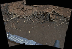
Sol 930 Right Mastcam image of a dump pile, probably of the Telegraph Peak drill powder.
This simplifies arm movements, e.g. for MAHLI wheel imaging, and opens an option for a next drilling.
With respect to the Garden City MAHLIs, here an annotated crop of this Sol 930 MAHLI:
Click to view attachment
With an interpretation of the darker phase as partially brecciated mudrock, having lithified a little faster than the light-toned fine-grained phase, I could get a more or less consistent view of the image. Both phases look rather resistant to erosion by considering the angularity of the surface; the darker phase maybe a little more resistant than the light-toned phase. Each of the two presumed phases may vary a bit in composition.
The part which doesn't like to fit easily into this interpretation are the parallel-looking features I've annotated by green lines.
Initially I've been looking for cleavages to narrow down mineralogy, but instead found these linear structures, which don't seem to care too much about the remaining structuring of the rock.
My take on MAHLI close-up on those mineral veins. Images are corrected from artifact and color corrected:

QUOTE (Gerald @ Mar 21 2015, 10:21 AM)
The part which doesn't like to fit easily into this interpretation are the parallel-looking features I've annotated by green lines.
The features that Gerald has highlighted look like healed fractures; that is, fractures that formed by a propagating crack tip but were not subsequently propped open by fluid or precipitating mineralization. They would have closed, reversing the extensional, opening mode void. The cross-cutting relationships suggest that this was an earlier fracturing episode since they terminate against the mineralized fractures (veins). The fracture faces of these features seem to have been slightly mineralized (Gerald's parallel-looking features), making them a bit more resistant to erosion and stand out in relief.
That sounds plausible. Thanks a lot for helping over this hurdle!
Mars is full of serendipity. You spend 6 months throughly exploring and studying a scientifically important area (Pahrump Hills), then hit the road and travel less than 100m before finding Garden City.
To explore Mars with less chance of driving by unseen treasures (just 100m away behind a hill or in the next canyon over), it would be nice to have a swarm or rovers or a rover with a drone scout
To explore Mars with less chance of driving by unseen treasures (just 100m away behind a hill or in the next canyon over), it would be nice to have a swarm or rovers or a rover with a drone scout
Another take on the extended R-MastCam mosaic from sol 929. I tried to add the images from 926, but had stitching issues, working on resolving those (edit : link repaired)
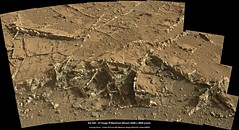
Link 1024 x 556
Link 2048 x 1112
Link 8488 x 4608
Link 1024 x 556
Link 2048 x 1112
Link 8488 x 4608
QUOTE (Floyd @ Mar 22 2015, 01:54 PM)
it would be nice to have a swarm or rovers or a rover with a drone scout
Luckily, the drone scout might just be on its way.

A (probably failed) attempt to find fluorescence in the Sol 935 MAHLI night shots:
Starting from this Sol 935 MAHLI white LED night shot, RGB channel-wise histo stretch returned this image:

Starting from this Sol 935 MAHLI uv LED night shot, perliminary cleaning by subtracting a Sol 910 night image without LED returned this image

then RGB channel-wise histo stretch returned this one:

Subtraction of the histo stretched white LED image from the cleaned and histo stretched uv LED image returned this image:

Histo stretch of the difference image returned this result:

In the latter image I wasn't able to indentify fluorescence or phosphorescence uniquely.
Most variations are probably due to shadows and slightly different positions of the LEDs (my preliminary interpretation).
Starting from this Sol 935 MAHLI white LED night shot, RGB channel-wise histo stretch returned this image:
Starting from this Sol 935 MAHLI uv LED night shot, perliminary cleaning by subtracting a Sol 910 night image without LED returned this image
then RGB channel-wise histo stretch returned this one:
Subtraction of the histo stretched white LED image from the cleaned and histo stretched uv LED image returned this image:
Histo stretch of the difference image returned this result:
In the latter image I wasn't able to indentify fluorescence or phosphorescence uniquely.
Most variations are probably due to shadows and slightly different positions of the LEDs (my preliminary interpretation).
This is a "lo-fi" version of our main content. To view the full version with more information, formatting and images, please click here.