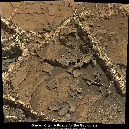
The newly brushed target (Sol 936) close to the complex Garden City vein seems to be very soft again (well-scratchable by the brush).
The rock contains grains (clusts, concretions,...) which appear harder (more erosion-resistant) than the matrix. The interior of the rock looks greyish relative to the rind.
This is a really zoomed in crop, my brain/eyes can't make sense of anything any closer.
The detail is great, the only problem is that I can no longer focus on my keybooorf!!
Click to view attachment
The detail is great, the only problem is that I can no longer focus on my keybooorf!!
Click to view attachment
QUOTE (algorithm @ Mar 26 2015, 10:21 PM) 
This is a really zoomed in crop, my brain/eyes can't make sense of anything any closer.
...
...
For left red, right blue, I'd say the channels should be exchanged.
QUOTE (Gerald @ Mar 26 2015, 06:52 PM)
The newly brushed target (Sol 936) close to the complex Garden City vein ...
If this were an image from Earth I would be querying raindrop impressions. Not suggesting they are, just noting the similarity.
QUOTE (algorithm @ Mar 26 2015, 10:03 PM)
The same brushed target as an anaglyph.
In the meanwhile the focus stacked version is available (anaglyph version) :

The motor count of the single image is 13961.
Here a version with the derived scale:

The size of the grains seems to be between about 0.5 and 1.0 mm.
There may be some fine layering.
My favorite interpretation would be a sandy mudstone/siltstone of fluvial (velocity about 30 cm/s) origin.
Here a version with the derived scale:
The size of the grains seems to be between about 0.5 and 1.0 mm.
There may be some fine layering.
My favorite interpretation would be a sandy mudstone/siltstone of fluvial (velocity about 30 cm/s) origin.
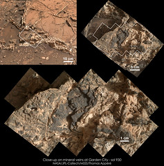
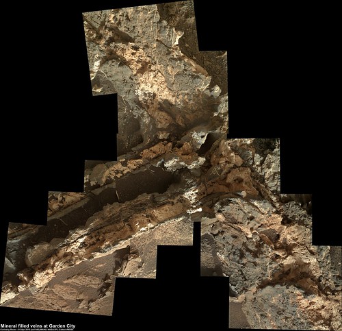
My turn to add a scale: I used the motor count of sol 930 MAHLI pictures to derive the scale for these mosaics of veins at Garden City:
Any way you cut it the rock is black & white. Seems this area is a mantel breach of some type. The black rock being mantel basalt.
Basalt would be very surprising as a vein fill.
The veins are probably the result of some kind of groundwater activity (fluids).
Transported or solved minerals have been precipitated in fractures, or even extended the fractures.
In a previous post T. Demko provided a link to very detailed explanations.
The veins are probably the result of some kind of groundwater activity (fluids).
Transported or solved minerals have been precipitated in fractures, or even extended the fractures.
In a previous post T. Demko provided a link to very detailed explanations.
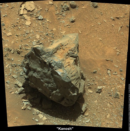
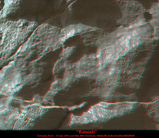
R-Mastcam mosaic of the sol 940 target "Kanosh"
Edited
Edited
Cap rock "Kanosh" Sol 940, Mastcam L/R, x-eyed, and anaglyph version:


interesting little 'filament' at the bottom of the image here, theres no parellax betweent he two sol940 m100s, and the m34 doesnt provide enough resolution in the second crosseye, nonetheless it does seem to be half embedded in and thus eroded out of the rock (outcrop?) at its left, as opposed to being a segment of cleanly detached fill vein as if jetsam from Kanosh.
Click to view attachment Click to view attachment
Click to view attachment Click to view attachment
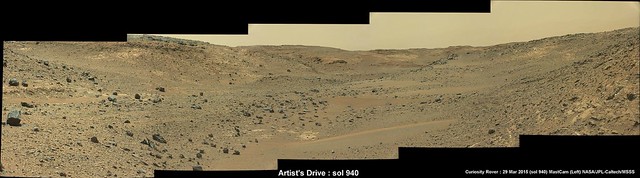
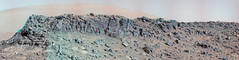
A better look down Artist's Drive. Sol 940, left mast camera.
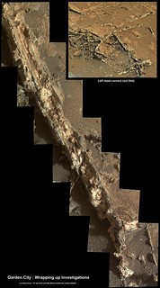
Also a possible return to Garden City : USGS update for Sols 942-943
Also a possible return to Garden City : USGS update for Sols 942-943
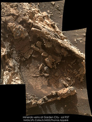
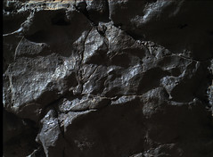
A rock of Garden City imaged with MAHLI on sol 937:
MAHLI close-up of Kanosh on sol 942 (red/cyan anaglyph)
4-image, R-MastCam Mosaic : Looking deeper into Artist's Drive (Sol 942)

QUOTE (PaulH51 @ Apr 1 2015, 12:41 AM)
Also a possible return to Garden City : USGS update for Sols 942-943
The decision has been made:
Sols 944-945: Return to Garden City
Jan's sol 940 panorama in circular form - it shows the path through the valley quite clearly, and the view back to Pahrump Hills..
Phil
Click to view attachment
Phil
Click to view attachment
A NavCam anaglyph of the Garden City, Sol 944
Click to view attachment
Here in England, we've had garden cities since 1898, http://en.wikipedia.org/wiki/Garden_city_movement, I think this pre-dates that though,
Click to view attachment
Here in England, we've had garden cities since 1898, http://en.wikipedia.org/wiki/Garden_city_movement, I think this pre-dates that though,
6 image mast camera mosaic of the extended veins at Garden City, images acquired after the drive during sol 944 (April 03, 2015
Contrast marginally stretched to highlight the different surface materials.
Contrast marginally stretched to highlight the different surface materials.
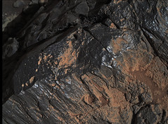
A section of the mineral filled veins at Garden City acquired on sol 946 (9 MAHLI frames) EDIT : Additional frame added (now 10 MAHLI frames) and roughly stitched and rotated to provide a little context with some earlier mast camera images (sol 929)
 ....
....
....
Nicely done Paul. A consensus seems to be forming that the veins seen here and at Sheepbed represent hydraulic fracture fill. This indicates that the mudstone must have been covered to depth certainly no less than a kilometre and probably much more. But it also implies that there would be a significant thickness of sediment below the mudstone which compacted to provide the high pressure solution necessary to fracture the mudstone cap and form the fracture fill. This means that the basal unit could be much deeper than suggested by Anderson and Bell in their outstanding landing site selection paper.
QUOTE (serpens @ Apr 6 2015, 08:10 AM)
... A consensus seems to be forming that the veins seen here and at Sheepbed represent hydraulic fracture fill....
Thanks Serpens. Earlier I was studying the mineral layering in this particular part of the vein and noting the amount of separate mineral veins. I can not even begin to imagine how long these took to form, but now I can begin to appreciate why they decided to return to this location to gather more data before heading towards the mountain once again.
Yeah, I can see why they want more mineralogy and it will be interesting to get the take of the experts. I don't know if it is just my deranged imagination but there seems to be a couple of examples of sigmoidal fracture fill in your image at post #76 which could imply rotation of segments of mudstone. The thicker white fracture fill which I assume is the ubiquitous calcium sulphate could imply hydration of anhydrite to gypsum which gives a hefty increase in volume.
QUOTE (serpens @ Apr 6 2015, 03:34 PM)
....a couple of examples of sigmoidal fracture fill in your image at post #76
This small R-MastCam mosaic may help you decide if one of those areas is a sigmoidal fracture fill, differential erosion, or something else entirely
This is certainly an interesting location, whatever these features are
While following this thread, I saw this come by my news feed. Visually similar to my non-geologist eye.
http://www.dpreview.com/galleries/30650321...um=death-valley

http://www.dpreview.com/galleries/30650321...um=death-valley
QUOTE (PaulH51 @ Apr 6 2015, 09:18 AM)
This small R-MastCam mosaic may help you decide if one of those areas is a sigmoidal fracture fill....
I was thinking more along the lines of the "S" and "C" structures here.
QUOTE (serpens @ Apr 6 2015, 08:17 PM)
I was thinking more along the lines of the "S" and "C" structures here.
OK
I'll watch out for any R-MastCam images that may help.
Some of our latest processing
sol 938 anaglyph
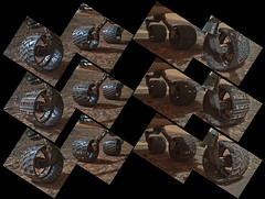
wheels sol 939
Kanosh anaglyph sol 940

and some more vivid MAHLI sol 942

@PaulH51 nice composition!
sol 938 anaglyph
wheels sol 939
Kanosh anaglyph sol 940
and some more vivid MAHLI sol 942
@PaulH51 nice composition!
craigmcg, thank you for uploading that photo. Has helped me put it into a Terran context. Have similar geological processes produced what we're seeing at Garden City?
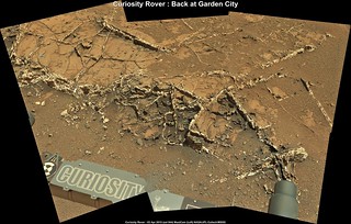
PaulH51, 'A Puzzle For The Geologists' wow pretty impressive mosaic, how long did it take you to do? Were the images literally taken from the raw images page on NASA's site here http://marsmobile.jpl.nasa.gov/msl/multime...?s=#/?slide=946 , and then stitched together by yourself? Loved it anyway!
PaulH51, 'A Puzzle For The Geologists' wow pretty impressive mosaic, how long did it take you to do? Were the images literally taken from the raw images page on NASA's site here http://marsmobile.jpl.nasa.gov/msl/multime...?s=#/?slide=946 , and then stitched together by yourself? Loved it anyway!
QUOTE (serpens @ Apr 5 2015, 07:10 PM)
A consensus seems to be forming that the veins seen here and at Sheepbed represent hydraulic fracture fill. This indicates that the mudstone must have been covered to depth certainly no less than a kilometre and probably much more. But it also implies that there would be a significant thickness of sediment below the mudstone which compacted to provide the high pressure solution necessary to fracture the mudstone cap and form the fracture fill.
Yes, the source of the overpressure that resulted in the brittle tensile failure of the mudstone is where my curiosity(!) lies. An authigenic or mineralogic volume increase, as you've stated, could certainly be a good candidate, especially when dealing with anhydrous and hydrated sulphate minerals. Hydrated clays also can exhibit significant volume changes as water is added and lost from their crystal lattice. Deep burial, on its own, should not cause this type of feature. Deep burial followed by quick exhumation, on the other hand, can do this, in the presence of isolated pressure cells (here the sandstone and mudstone strata). Other terrestrial causes include biogenic and thermogenic hydrocarbon generation, although when this happens at deepest burial, horizontal, rather than vertical tensile fractures can form (the famous "beef" veins of the Yorkshire, Dorset, and Somerset Jurassic exposures). It is interesting that you are seeing sigmoidal fractures and C-S features, suggesting some horizontal stress and shear in addition to the burial/vertical/lithostatic stress. In terrestrial fracture fills associated with overpressure, calcite crystallizes in veins as a distinctive cone-in-cone fabric when there is a component of horizontal stress, rather than the prismatatic, fracture-spanning "beef" fabric associated with overcoming lithostatic stress (nice review article, behind a paywall, here).
The go-to analyses to really determine the source of the overpressure involve determining the phase/PT behavior and composition of fluid inclusions in the fracture fill minerals. Certainly would be candidates for caching for a possible sample return, or reason for including such instrumentation on a future landed mission.
Deep burial and exhumation could be due to filling of accommodation followed by landscape degradation via erosion, or growth and decay of a thick ice sheet.
(sorry for the additional post, but...I'm a Member!...finally!...100 posts!...it only took 11 years!)
(sorry for the additional post, but...I'm a Member!...finally!...100 posts!...it only took 11 years!)
QUOTE (Mr. Bergstrom @ Apr 7 2015, 04:41 AM)
PaulH51, 'A Puzzle For The Geologists' .... how long did it take you to do? Were the images literally taken from the raw images page and then stitched together..
Yes, less than a minute to stitch the raw images using "Microsoft Image Composite Editor" (ICE) MS ICE home page I use an older version V1.4.4.0 which I prefer to V2.0. There are many better tools, but this one works for me. PhotoScape then used to add the annotations etc. There is a thread for "MSL Images & Cameras, technical discussions of images, image processing and cameras" Kindly use that thread if you have any other queries re MS ICE, plus there is a host of great material there worth studying
One of the many ChemCam-RMI targets acquired in recent days. Shown here in context with its location at Garden City.
Roughly stacked and converted to a red/cyan anaglyph

Roughly stacked and converted to a red/cyan anaglyph
Evidence of laser strikes observed on a ChemCam target on the last planned full day of science at Garden City (sol 948)

The last images are down and here is the complete Navcam L Panorama
taken on Sol 944.
Jan van Driel
Click to view attachment
taken on Sol 944.
Jan van Driel
Click to view attachment
Another section of the Garden City mineral filled veins captured by Curiosity on sol 948.
EDIT : Added another 7 frames (total = 14) There is a lot of overlap with the first mosaic, but the additional frames finish it off well
 . . . .
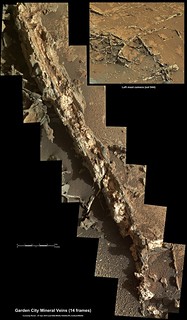
Scale bar added
EDIT : Added another 7 frames (total = 14) There is a lot of overlap with the first mosaic, but the additional frames finish it off well
. . . .Scale bar added
QUOTE (tdemko @ Apr 7 2015, 01:25 AM)
Deep burial and exhumation could be due to filling of accommodation followed by landscape degradation via erosion, or growth and decay of a thick ice sheet.
(sorry for the additional post, but...I'm a Member!...finally!...100 posts!...it only took 11 years!)
(sorry for the additional post, but...I'm a Member!...finally!...100 posts!...it only took 11 years!)
Congrats to the 100 then, yet better with quality over quantity. =)
Thank you for your thoughts on this site, and I think you nailed it with your second post there. I have a hunch that what we see is the result of both mechanical stress and erosion and pressure that happened during one ice epoch. Like craigmcg I have also seen something similar in sandstone with mineral veins of calcium, where the the last ice age is thought to have removed part of the sandstone. I am going to work outdoors in the coming weeks, if I pass by of one of the two sites where its found I might snap a picture and post one Earth comparison image here. =)

Thanks, Jan and Gerald, for your panoramas. I made a composite of the two (to clean up the view of the valley behind us) and made a circular version. We get a good view along the valley from here.
Phil
Click to view attachment
Phil
Click to view attachment
Partial Navcam L Panoramic view on Sol 950.
The rest of the images will be added when they are down.
Jan van Driel
Click to view attachment
The rest of the images will be added when they are down.
Jan van Driel
Click to view attachment
This is a "lo-fi" version of our main content. To view the full version with more information, formatting and images, please click here.