Help - Search - Members - Calendar
Full Version: Exploring Mt Sharp north of the dunes - Part 1: Beyond Pahrump Hills
Unmanned Spaceflight.com > Mars & Missions > MSL
Pages: 1, 2, 3, 4, 5, 6, 7, 8, 9, 10, 11, 12, 13, 14, 15, 16, 17, 18, 19, 20
Arizona Dave
QUOTE (Floyd @ May 4 2015, 05:12 PM) *
Dave
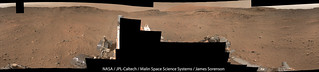
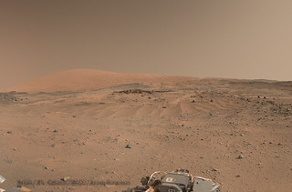
Martian sky color has be much discussed here in dozens if not hundreds of threads and you can find out a lot by searching and reading. Orange is usual--close to what we would see if there--blue shows up in color stretched images and some sunsets. Skies are only blue on Mars if you are in a spacecraft above a high percentage of the atmosphere...


Yeah, Ive read dozens of topics on the sky color, and probably hundreds of posts, including a lot form Nasa, Ive been left with the conclusion that the color is difficult to really ascertain because we just dont have a human eye up there. Ive actually got several non color stretched images from Curiosity that show fairly blue sky, also from Opportunity, and then a few days later, what I call muddled orange sky.

The thing that strikes me at all with mars is at 1% atmosphere as Earth, why the sky is even bright at all, in order to get to 1% ATM on earth you have to be approx 100,000ft elevation, this is 2/3rd the way through the Earth's atmosphere, and according to NASA: "You can start to get a feel for how high 100,000 feet is by remembering that commercial jets travel at about 30,000 feet. 100,000 feet is about 2/3 of the way through the stratosphere, and the majority of the mass of the earth's atmosphere is below the balloon at that height. You can tell that there are fewer gas molecules at 100,000 feet when you see video from the balloon. The sky is as black as night, but the sun is still visible."

Anyway, I just find it very interesting regarding Mar's ever changing Sky's...I wonder sometimes if a lot of the light is IR or UV that basically just is being picked up by the camera sensors, like taking the filters off a home camera...you get to start seeing things your eye cannot.

EDIT: I think I came across a few more articles that describe a juxtaposition of sorts regarding Mars vs Earth sky colors, especially regarding time/day and sun direction...and horizon vs overhead. Makes more sense why it seems to vary so much from image to image.

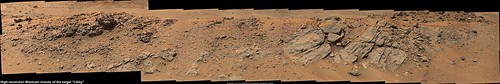
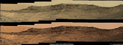
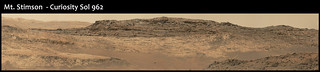
Thx for the reply, now...back to the new rocks...they are awesome! every corner in the crater has something so different that before, does anyone else think they look yummy...like thin layers of crepes? :-) LOL
mcaplinger
QUOTE (Arizona Dave @ May 5 2015, 10:07 AM) *
Ive been left with the conclusion that the color is difficult to really ascertain because we just dont have a human eye up there....

I don't this this is a fair conclusion. The reason you see wide variation is from two sources: first, most images one sees have been processed in ways that distort the color, but the processing is rarely described or consistent, and second, the martian sky simply varies a lot in color depending on the amount of dust, the time of day, and the relative position of the sun. Sky color on Mars is dominated by Mie scattering from suspended dust, which is a much different phenomenon than the Rayleigh scattering from gas molecules that prevails on Earth.
QUOTE
I wonder sometimes if a lot of the light is IR or UV that basically just is being picked up by the camera sensors

Not really. Filter 0 on the Mastcams is very similar to the standard IR cut filter on a commercial camera. If anything, it passes a bit less blue than is typical.
fredk
For a careful study of the sky colour, see this paper.
James Sorenson
It's been awhile since I last posted, yet alone for MSL. Here is the Sol-952 pan. It's not finished yet, but here is a downsized preview. smile.gif


scalbers
QUOTE (fredk @ May 5 2015, 05:38 PM) *
For a careful study of the sky colour, see this paper.

Looks like a good and recent synopsis overall. I like to point out also the dependence of the dust phase function on wavelength with Mie scattering. With the appropriate dust size distribution we get via diffraction a slightly bluer color surrounding the sun that is actually independent of the dust composition, then the color becomes more related to the dust composition (and redder) at farther angles from the sun. Based on one of the references led by Jim Pollack cited in the above paper, I rendered this in another thread here.

I also have a rendering for a "launch" from Earth up to the stratosphere at 40km above ground level, where ground level is 1.5km above sea level. I think about 28km MSL (two-thirds through the animation) would be the equivalent of Mars' atmospheric optical thickness if there wouldn't be any dust. We can see how the sky gets a blue/black color as we go up. Here is a still frame for the best altitude.
atomoid
QUOTE (Gerald @ May 5 2015, 09:59 AM) *
As fragile as the laminae look from a distance, they seem to be much more abrasion resistant than the soft rock at Pahrump: No trace of a scratch from the DRT.

quite remarkable really, what looks so sandstony in the nav/pancams but under MAHLI reveals almost as if its some kind of shale, wonder what chemcam may suggest?

on another note, i'm always perplexed (tricked) seeing apparent appearance of rocks atop dunes (the little ones at lower left). without a stereo view there may be misleading perspective cues here, anyways the pebbles halfway up the dunes must merely be exposed tops of larger cobbles.
walfy
Haven't done one of these for awhile. So cool to see in 3D. smile.gif
From sol 975.

Click to view attachment
elakdawalla
That is really awesome smile.gif
Arizona Dave
QUOTE (atomoid @ May 5 2015, 02:43 PM) *
quite remarkable really, what looks so sandstony in the nav/pancams but under MAHLI reveals almost as if its some kind of shale, wonder what chemcam may suggest?

on another note, i'm always perplexed (tricked) seeing apparent appearance of rocks atop dunes (the little ones at lower left). without a stereo view there may be misleading perspective cues here, anyways the pebbles halfway up the dunes must merely be exposed tops of larger cobbles.


I noticed that as well, and the close-up images suggest an almost semi-gloss luster rather than a drab flat surface...in a few of the close ups, and im sure its a trick of lighting, I can imagine these being "wafers" of gold or platinum :-) ahhh...now wouldnt that be neat :-)
PaulH51
R-MastCam pano, sols 953 & 955 using 59 of the 60 full frames

Click image for 2048x167 version, or this LINK for the full size image 32051 x 2608
PaulH51
Sol 976 drive direction caught me by surprise smile.gif I was expecting it to double back to enter Logan Pass, but looking at Joe's map we have continued the drive South West. LINK to Joe's interactive drive map. The reported drive distance would break the record if confirmed (262.38 meters)
Click to view attachment
Phil Stooke
I think something is wrong there. We should be about 65 m east of the last stop.

Phil

PaulH51
QUOTE (Phil Stooke @ May 6 2015, 07:52 PM) *
I think something is wrong there. We should be about 65 m east of the last stop.

I think you are right... Probably corrupted NAIF data....

Meanwhile here are the 28 R-MastCam images of "Libby" back on sol 958

LINK to full size
Dig
Left Navcam Sol 976 Full Resolution.


Click image for full resolution.

My Curiosity Pinterest Board
Phil Stooke
Very nice! Here's a circular version. There's a nice view down the valley to the south, presumably our approach to Logan Pass.

Phil

Click to view attachment
Floyd
Ouch, the drive ahead to the SSW is strewn with pointy rocks--just what the wheels don't need.
jvandriel
Here is my view of the Sol 976 Navcam L panorama.

Jan van Driel

Click to view attachment
nogal
QUOTE (Phil Stooke @ May 6 2015, 12:52 PM) *
I think something is wrong there. We should be about 65 m east of the last stop.

Definitely. As the end of drive images demonstrate. I'm waiting for the "Where is Curiosity?" page to refresh before plotting it.

Fernando
PaulH51
USGS Curiosity Mission Update from Ryan Anderson "Sol 978-979: Jocko Chute"
Gives us a new place name "Jocko Chute" and a few new targets for us to try and find in the future images smile.gif
algorithm
FHaz anaglyph from Sol977


Click to view attachment
PaulH51
Sol 976 : L-MastCam: Drive Direction mosaic

Full size (5748 x 1335) LINK
Phil Stooke
Just a short drive overnight, sol 978, maybe 6 m or so, a bit closer to the 'chute'. (EDIT - not even that much! - just a couple of meters.)

Phil

Click to view attachment
neo56
Here is the complete panorama taken with MC100 on sols 953 and 955 at 17h local time:


And two close-up on scenic views:


charborob
Sol 962 mastcam100 panorama:
Click to view attachment
Floyd
Thomas (neo56) your postcard close-ups are fantastic! Thanks
Dig
Left Navcam Sol 978 Full Resolution.


Click image for full resolution.

My Curiosity Pinterest Board . Flickr Gallery
jvandriel
and the complete Navcam L view on Sol 978.

Jan van Driel

Click to view attachment
Phil Stooke
Lots of new names on the latest update video on the MSL website! Now, if only I could read all of them. One thing I am sure of... I have absolutely no idea where that "West Ridge" from sol 959 is supposed to be. Just too many choices. If anyone can enlighten me i would be very grateful.

Phil

PaulH51
QUOTE (Phil Stooke @ May 9 2015, 06:22 AM) *
Lots of new names on the latest update video on the MSL website! Now, if only I could read all of them. One thing I am sure of... I have absolutely no idea where that "West Ridge" from sol 959 is supposed to be. Just too many choices. If anyone can enlighten me i would be very grateful.
Phil

Ryan's USGS Mission Update for sol 959-961 calls for a 17x1 mosaic of West Ridge. I used Joe's 'synth' page for station 278. It lists 95 L-MastCam images, with 89 of them from sol 959, I can only find one sequence of 17 images, all start with 0959ML0042470. Hope that helps.
Phil Stooke
Thanks, Paul. The trouble is, that sequence spans about 200 degrees of azimuth. I think the most likely thing is that West Ridge is the rocky spur north of the rover at that time, and west of Artist's Drive. In the past I had assumed it was west of that rover location or perhaps west of Logan Pass. Ultimately I will get this from the Analyst's Notebook section of PDS Geosciences, but for now I will make this assumption. Anyone who uses my maps should be aware that they are a work in progress, always subject to revision!

Phil

Phil Stooke
This is a circular version of Dig's panorama shown just above.

Phil

Click to view attachment
James Sorenson
What we saw back at "Logans Run".

Flickr 3D Anaglyph:

Flickr M-100:

Gigapan 3D Anaglyph:
http://www.gigapan.com/gigapans/172399
Gigapan M-100:
http://www.gigapan.com/gigapans/172400
Dig
Left Mastcam (M-34) Sol 978.


Click image for full resolution.

My Curiosity Pinterest Board . Flickr Gallery
scalbers
QUOTE (jvandriel @ May 8 2015, 09:02 PM) *
and the complete Navcam L view on Sol 978.

Jan van Driel

Click to view attachment

Just to help me get oriented, I wonder where north would be in this panorama, along with the azimuths of Jocko Butte & Chute? I'll guess the Butte is just right of the center and the Chute 60 degrees right of the Butte, if this is close to a 360 view.

Would we anticipate the eventual route will go over Logan Pass, if that is safe enough?
Phil Stooke
Steve, the circular version I made (just a few posts above yours) is oriented approximately with north at the top, so that helps you find directions. I don't measure orientation to the nearest degree, but I compare the circular pan with a HiRISE image.

Phil

scalbers
Thanks Phil - then the Butte would be on the right side of your circular pan. And in Dig's color image 3 posts up, the Butte is on the left and Chute on the right.
algorithm
The Front HazCam view from Sol979 as an anaglyph.


Click to view attachment
algorithm
I am trying to decide whether the rock within the elipse (from the anaglyph in my previous post), is sitting on top of, or jutting out from, the sand ripples.

If it is sitting on top of the ripples then wouldn't that make it a relatively new arrival to the scene?


Click to view attachment


fredk
We haven't gotten very many good views of clouds with MSL, but there were some subtle clouds in a sol 937 navcam cloud sequence. Here's an animation of the 8 frames, each minus the average of the eight, and then stretched and low pass filtered:
Click to view attachment
jvandriel
The Navcam L panoramic view on Sol 981.

Jan van Driel

Click to view attachment
Phil Stooke
Thanks, Jan - here is a circular version of it.

Phil

Click to view attachment
jvandriel
The Mastcam R view on Sol 980.

Jan van Driel

Click to view attachment
jvandriel
an old but nice one from Sol 959.

Jan van Driel

Click to view attachment
Arizona Dave
QUOTE (neo56 @ May 8 2015, 04:02 AM) *
Here is the complete panorama taken with MC100 on sols 953 and 955 at 17h local time:
And two close-up on scenic views:


Wow! did you do any color processing on these? The depth is amazing, surreal.
Arizona Dave
Wow, http://mars.jpl.nasa.gov/msl-raw-images/ms...859E01_DXXX.jpg

Anyone have any ideas on the grey and whitish colored materials, they sure look "fresh" or newer than the surrounding materials, almost looks like ash/sulfides. Wonder if they are taking new/ongoing methane or other gas measurements?
elakdawalla
Curiosity drove over this spot right before the end of the drive on sol 978, cracking the rocks and exposing fresher (grayer, whiter) surfaces in the gray rocks and white (likely sulfate) veins we've been seeing in this area.
PaulH51
My take on the 980 R-MastCam, gives us a nice look at the interface between the Washboard unit and the Murray Formation, located on upper reaches of the south wall of Logan Pass (Mount Stimson)

Full size (7716 x 2854 pixels) LINK
Arizona Dave
QUOTE (elakdawalla @ May 11 2015, 01:34 PM) *
Curiosity drove over this spot right before the end of the drive on sol 978, cracking the rocks and exposing fresher (grayer, whiter) surfaces in the gray rocks and white (likely sulfate) veins we've been seeing in this area.


Looking closer I can def see the disturbances from the rover, but not sure it looks like wheel tracks, maybe they were poking around, but for sure disturbed the area and looks like even pushed a few rocks around.

I try to keep an eye daily on Curiosity and Opportunity, speaking of which, Opp took some images of really interesting rocks...the colors are crazy, it seems like after the duller periods, these rovers keep bumping into things that make it interesting again...I wonder just how far Curiosity will get on its poor wheels, It would be awesome to get part way up Mt Sharp and take some really cool vista images.
Zelenyikot
Funny ventifact at sol 978.
jccwrt
The sol 962 view of Mt. Stimson had a great view of the contact between "Washboard" and the Murray formations, so I thought an annotated version would be good to highlight the geology of the area:


Full-size (6675x1500) LINK


Full-size (6675x1500) LINK

The contact kind of reminds me of a channel scour along I-40 in Tennessee (Link goes to Google Maps view). I've developed the unit descriptions based on the images coming down through Midnight Planets, so I think they're accurate but do feel free to correct me if I'm wrong. I'm working on a portion about the specific environment of deposition I've pulled out my old textbook and have been brushing up on lacustrine and alluvial settings. It's been a long time since sed/strat, so any suggestions for more specific stuff to look into would be appreciated. Thanks!
This is a "lo-fi" version of our main content. To view the full version with more information, formatting and images, please click here.
Invision Power Board © 2001-2024 Invision Power Services, Inc.