serpens
Apr 28 2015, 07:01 AM
QUOTE (Phil Stooke @ Apr 27 2015, 08:11 PM)

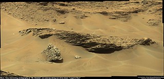
..... Presumably these outcrops in front of us are Logan's Run... ..
.
Actually the view is Mt. Shields - the wheels are on Logan's Run. Not sure about accessibility but these are nicely differentiated outcrop layers.
Phil Stooke
Apr 28 2015, 10:08 AM
Yes... the new USGS blog gives us the details. I'm hoping for one of Fred Calef's nice maps annotated with placenames to give me some more certainty about other names.
Phil
PaulH51
Apr 28 2015, 10:25 AM
QUOTE (Phil Stooke @ Apr 28 2015, 06:08 PM)
I'm hoping for one of Fred Calef's nice maps annotated with placenames....
You may not have to wait too long, Fred has been tweeting this seek as astrotweeps... Here is a little preview he gave
https://twitter.com/astrotweeps/status/592755331815624705
Gerald
Apr 28 2015, 11:21 AM
QUOTE (Phil Stooke @ Apr 27 2015, 10:44 PM)
... but why divert to Logan's Run rather than go straight to Logan Pass? ...
If asked where to take samples along the direction marked by the dark red line in this annotated crop
Click to view attachment of the file
mars-rover-curiosity-msl-traverse-map-10k-drive-Sol957-PIA18390-br2.jpg (full-res
here) - given limited ressources - to test linear models of the Washboard unit, I'd prefere points far apart in terms of projections onto the coordinate axis of interest, since interpolation is most sensitive to the lower and upper bound of the considered interval:
Click to view attachmentSo under the aspect to find out a trend roughly along the marked dark red line in the annotated crop above, the decision to look at Logan's Run/Mt. Shields makes sense, without knowing whether this consideration has actually been part of the decision process.
Phil Stooke
Apr 28 2015, 02:11 PM
"You may not have to wait too long, Fred has been tweeting....."
Excellent, thanks! Just using that I have been able to fix and add to my map, so there is an updated route map today.
Phil
algorithm
Apr 29 2015, 02:11 PM
Sol 967 NavCam images cropped as an anaglyph.
Click to view attachment
algorithm
Apr 29 2015, 03:23 PM
Another Sol967 NavCam anaglyph, showing how stoney it is around here. Hopefully lots of soft sandy soil to push them into.
Click to view attachment
algorithm
Apr 29 2015, 05:54 PM
algorithm
Apr 29 2015, 06:22 PM
With reference to post #626, I noticed that the right 55% or so of the image is predominantly sand and the left mostly stoney.
I kind of assumed that it was to do with the prominance of the rocky outcrops catching wind blown grains, and therefore defining some sort of boundary, would this be correct?
atomoid
Apr 29 2015, 09:09 PM
..you probably mean
post#256? if so id assume the opposite cause, sand dunes likely indicating the prevailing wind patterns with the leeward side of the ridge where the sand collects atop the otherwise similar stony terrain sourced from the windy side where it is blown relatively quickly off of over to the leeward side. in any case the question remains how long has it taken for this to accumulate?
PaulH51
Apr 30 2015, 12:26 PM
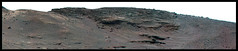
sol 969, 6x3 R-MastCam mosaic of a section of the "Mt. Shields" outcrop.
This mosaic is mentioned in the latest USGS Mission Update "Sol 969-970: Studying Mt. Shields"
LINK
Gerald
Apr 30 2015, 01:03 PM
dburt
Apr 30 2015, 06:18 PM
Possible, but there are several depositional environments that can have inclined bedding. This is just an isolated small outcrop. I'd probably want to see more of the package (e.g., a complete sandwich including horizontal topset beds on top and bottomset beds underneath) before arriving at such a hypothesis.
dburt
fredk
Apr 30 2015, 11:45 PM
Pebble going for a ride:

PaulH51
May 1 2015, 08:15 AM
Partial left navcam pano of the arrival at the Mt Shields outcrop.

jvandriel
May 1 2015, 08:48 AM
Partial Navcam L view on Sol 971.
Jan van Driel
Click to view attachment
MahFL
May 1 2015, 11:30 AM
Reminds me of Spirit in Eagle Crater

.
jvandriel
May 1 2015, 01:26 PM
and here is the complete view on Sol 971.
Jan van Driel
Click to view attachment
fredk
May 1 2015, 01:52 PM
QUOTE (MahFL @ May 1 2015, 12:30 PM)
Reminds me of Spirit in Eagle Crater
I don't think Spirit made it quite that far around the planet...

PDP8E
May 1 2015, 09:07 PM
Fred,
it took me a couple of seconds, but that was pretty funny....
Habukaz
May 1 2015, 10:20 PM
The way things are turning out, I think it would be more likely to see Opportunity in Gusev Crater.... where it could nudge Spirit back into life, and then they can travel to Eagle Crater together.

Gladstoner
May 1 2015, 11:41 PM
Who's on Home Plate?
PaulH51
May 1 2015, 11:53 PM
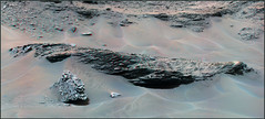
Delicate layering at Mt Shields - sol 971 L-MastCam

PaulH51
May 2 2015, 04:51 AM
USGS Curiosity Mission Update from Ken Herkenhoff :
Sol 973-975: Albert, Bigfork, and Charity
PaulH51
May 2 2015, 05:27 AM
Drive direction? mast camera mosaic looking SSE, sol 971. Maybe for when they finish up at Mt Shields?

Phil Stooke
May 2 2015, 07:59 AM
A circular view of the current location on sol 971, from Jan's panorama.
Phil
Click to view attachment
PaulH51
May 2 2015, 09:07 AM
Locations identified for 2 of the recent ChemCam-RMI targets at Mt Shields (R-MastCam 969, RMI's 970 & 971)

eliBonora
May 2 2015, 09:38 AM
Here 2 last our anaphyphs
sol 964
and sol 969
blake
May 2 2015, 02:59 PM
Those layers "look" extremely delicate.
Amateur Question: Would the arm or turret ever be used to try and break some of these rock layers (maybe by preloading the drill against it, for example)? Would there be any science gained from such an action (maybe to see the inside of a rock or measure shear strength)?
Just wondering, thanks.
Phil Stooke
May 2 2015, 03:04 PM
Absolutely not the arm! It's full of delicate equipment. But the wheels sometimes break rocks as they drive over them (Curiosity in Yellowknife Bay at Snake, for instance, or Opportunity at Pinnacle Island) and sometimes it's even done deliberately to create a fresh surface for analysis.
Phil
PaulH51
May 3 2015, 03:20 AM
ChemCam-RMI target from sol 973. I'm not sure if it is
"Albert" or "Charity"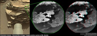
Phil Stooke
May 3 2015, 08:07 AM
It must be Charity, because according to the USGS blog Albert will be the site of DRT brushing later... and they would never brush that flimsy thing.
Phil
PaulH51
May 3 2015, 08:46 AM
QUOTE (Phil Stooke @ May 3 2015, 04:07 PM)
It must be Charity, because according to the USGS blog Albert will be the site of DRT brushing later... and they would never brush that flimsy thing.
Nicely deduced Phil... "Once you eliminate the impossible, whatever remains, no matter how improbable, must be the truth."
PaulH51
May 3 2015, 11:59 AM
Sol 953 R-MastCam, raw and stretched versions.

Full size
LINK
Gerald
May 3 2015, 03:30 PM
Some of the crêpe-like laminae have also been beneath the rover on Sol 972, here a
MARDI image processed by "dust-decoating", color modification (applying color-correction for Mastcam images), and linearization (squaring raw color values) :

neo56
May 3 2015, 04:59 PM
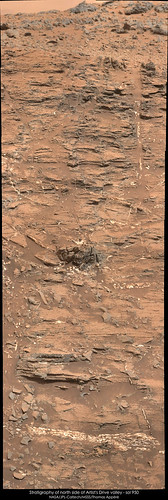
Some MC34 and MC100 mosaics of Artist's Drive valley which were downloaded lately:
North side of Artist's Drive valley with MC100 and MC34 on sol 950:

Southeast side of Artist's Drive valley with MC34 on sol 950:
Northwest side of Artist's Drive valley with MC34 on sol 951:

Tucki Mountain on southeast side of Artist's Valley with MC34 on sol 951:

centsworth_II
May 3 2015, 06:20 PM
QUOTE (Gerald @ May 3 2015, 10:30 AM)
Some of the crêpe-like laminae have also been beneath the rover on Sol 972....
It looks like a few shots of the ChemCam laser could bore a hole clear through one of those plates.
PaulH51
May 3 2015, 11:56 PM
Telescopic RMI imaging the distant target named 'Empire'
 LINK
LINK
PaulH51
May 4 2015, 02:33 AM
Roughly stitched overlapping MAHLI's from sol 974 (Mt Shields)
 LINK
LINK
Phil Stooke
May 4 2015, 02:14 PM
This is the location of Empire on a Navcam frame - it is south east of the rover.
Phil
Click to view attachment
algorithm
May 4 2015, 07:41 PM
An anaglyph from two focus merged MAHLI images from Sol974
Click to view attachment
neo56
May 4 2015, 07:53 PM
Arizona Dave
May 4 2015, 09:30 PM
Hopefully the wheels can make it
Arizona Dave
May 4 2015, 09:59 PM
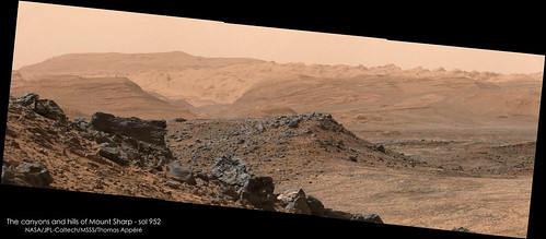
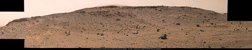
QUOTE (neo56 @ May 4 2015, 12:53 PM)
Panorama of the base of Mt Sharp and Grey Wolf Peak taken with MC100 on sol 952:
[/url]
A close-up on the hills and canyons of Mt Sharp. I'm looking forward to see Curiosity driving in this region!

That valley up the middle in the distance looks so similar to the Devils Corkscrew coming up out of the Grand Canyon! Awesome.
Question on Colors: Ive noticed several of the images were the sky has blue-ish tones, but recently the sky is very orange, is it just different angles/time of day, or is the color processing different? It doesnt seem like a dust storm because you can see so far and details on the hills that are 10-20 miles away, maybe upper atmosphere dust?
Gladstoner
May 4 2015, 10:53 PM
QUOTE (Arizona Dave @ May 4 2015, 04:59 PM)
That valley up the middle in the distance looks so similar to the Devils Corkscrew coming up out of the Grand Canyon! Awesome.
I'm reminded of the area around Moab, Utah. I can imagine the Slickrock Trail on the light-toned stuff.
Floyd
May 5 2015, 12:12 AM
Dave
Martian sky color has be much discussed here in dozens if not hundreds of threads and you can find out a lot by searching and reading. Orange is usual--close to what we would see if there--blue shows up in color stretched images and some sunsets. Skies are only blue on Mars if you are in a spacecraft above a high percentage of the atmosphere...
stevesliva
May 5 2015, 12:27 AM
QUOTE (Gladstoner @ May 4 2015, 05:53 PM)
I'm reminded of the area around Moab, Utah. I can imagine the Slickrock Trail on the light-toned stuff.
I believe that's Navajo sandstone, and it erodes into domes in a number of places, like the San Rafael Swell and Capitol Reef.
My own photo looking off the swell. Always think of that when I see Mt. Sharp.
Gladstoner
May 5 2015, 12:59 AM
QUOTE (stevesliva @ May 4 2015, 06:27 PM)
I believe that's Navajo sandstone, and it erodes into domes in a number of places, like the San Rafael Swell and Capitol Reef.
My own photo looking off the swell. Always think of that when I see Mt. Sharp.
The Navajo ss. is amazing, magical stuff.
PaulH51
May 5 2015, 01:53 AM
USGS Curiosity Mission Update from Ken Herkenhoff
"Sols 976-977: Onward to Jocko Butte"
Gerald
May 5 2015, 04:59 PM
As fragile as the laminae look from a distance, they seem to be much more abrasion resistant than the soft rock at Pahrump:
No trace of a scratch from the DRT.
This is a "lo-fi" version of our main content. To view the full version with more information, formatting and images, please
click here.