Thanks for that nice debayered result Gerald, you must have something other than the free debayer plugin for ImageJ, i didnt have much luck finding any for gimp/photoshop..
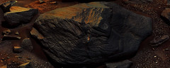
anyway onward to new pastures sol1073 and new glimpses of wind-exhumed blocks of ancient buried crater-ejecta/cliff-crumbles?
Click to view attachment
Yes, I've used a C++ compiler a while ago to get a very rudimentary debayering tool. The onboard debayering uses a more sophisticated 5x5 kernel, but I'm not sure whether the results would be much better with the lossy jpg version.
===
Here a Sol 1072 NRB pano:
Click to view attachment
In the meanwhile, there has been another drive on Sol 1073.
===
Here a Sol 1072 NRB pano:
Click to view attachment
In the meanwhile, there has been another drive on Sol 1073.
Preliminary Sol 1073 NRB partial pan:
Click to view attachment
Click to view attachment
Thanks, Jan - and Gerald for the previous sol. Here are two circular views at these locations:
1072:
Click to view attachment
1073:
Click to view attachment
Phil
1072:
Click to view attachment
1073:
Click to view attachment
Phil
Partial NRB pan after the Sol 1074 drive:
Click to view attachment
(Edit: replaced file with the correct one, see below, thanks Phil!)
Click to view attachment
(Edit: replaced file with the correct one, see below, thanks Phil!)
Oops! That's sol 1073!
Phil
Phil
Next time when I think "wow the layout resembles much the previous one" I better should look twice.
A first glimpse of a Sol 1073 ML mosaic, stitched of some of the thumbnails, using Hugin:
Click to view attachment
Click to view attachment
QUOTE (Gerald @ Aug 15 2015, 08:27 AM) 
A first glimpse of a Sol 1073 ML mosaic, stitched of some of the thumbnails, using Hugin:
Nice preview Gerald
 here are 34 full frames roughly stitched in MS ICE, colour and contrast have both been stretched to highlight the different surface textures/features.
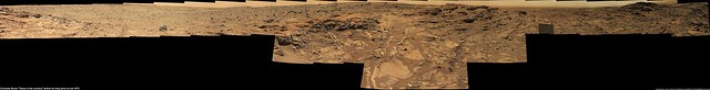
Clicking the preview will open the 1024 x 131 version
Original size LINK (25293 x 3230)
3x3 R-MastCam mosaic of "Crazy Mountain" (sol 1074). Roughly stitched in MS ICE, Contrast and colours stretched to highlight the "Interesting Banding" on this fallen?,or tilted bedrock?... Jury will remain out on that topic until we see some more bedrock in this new location
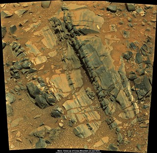
Clicking the preview image opens the 1024 mosaic on Flickr, this link opens the full size image (3374 x 3303 pixels) LINK
Clicking the preview image opens the 1024 mosaic on Flickr, this link opens the full size image (3374 x 3303 pixels) LINK
Crazy Mountain again but with a bit of tonemapping to try and bring out some detail in the shadows.
Click to view attachment
Click to view attachment
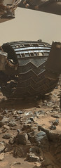
A contact test on the Organic free blanks...my guess is that they are preparing to drill into these soon and sample them. Very interesting arm and turret deflection. http://www.midnightplanets.com/web/MSL/sol/01076.html
QUOTE (James Sorenson @ Aug 17 2015, 09:22 AM)
A contact test on the Organic free blanks...my guess is that they are preparing to drill into these soon and sample them. Very interesting arm and turret deflection.
A good write-up from the 42nd Lunar and Planetary Science Conference (2011) on the OCM is here LINK
Also a sol 34 image of one of the OCM cans (for comparison), plus an informative write-up on the "touch points" (for the rover's drill posts) LINK
wheels... sol 1065

.... with a rock in balance, or caught?!?!
.... with a rock in balance, or caught?!?!
Curiosity Mission Update - Sols 1078-1079: Back to restricted planning from Ryan Anderson LINK
QUOTE
...another drive is planned for Sol 1078 with only the usual post-drive MAHLI (stowed) and MARDI (twilight) imaging. Planning is restricted again (Mars and Earth time are out of sync), so we are planning two sols. Before driving away from the current location, ChemCam and Mastcam will observe rock targets dubbed "Huson" and "Ignatius" and Mastcam will image another rock called "Hodown." After the drive, an overnight CheMin integration on the drill sample is planned, followed by atmospheric observations early on the morning of Sol 1079. More Navcam atmospheric observations are planned later that sol, along with some ChemCam calibration activities...
With the next drive imminent, here is the 'end-of-drive' L-MastCam mosaic from the last drive on sol 1074. Colour and contrast have been stretched to highlight the terrain.
clicking the preview opens the 1024 version, the link opens the full size (5696 x 1341) LINK
clicking the preview opens the 1024 version, the link opens the full size (5696 x 1341) LINK
Ken Herkenhoff seems to think we haven't reached Mount Sharp yet: "I'm glad that we are making good progress toward Mt. Sharp!"
There are far flanks, and the canyons on the mountain. We've been drilling into the former and have a ways to go to get to the latter. So we are at Mt Sharp and have a ways to go to get there 
RDR versions of those chemcam pics are available that have been flatfielded and show a lot more detail:
http://mars.jpl.nasa.gov/msl-raw-images/pr...CCAM01075L2.JPG
http://mars.jpl.nasa.gov/msl-raw-images/pr...CCAM01075L2.JPG
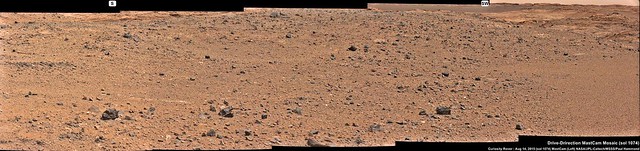
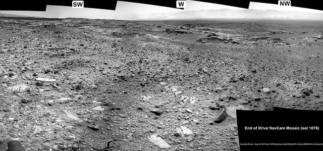
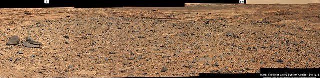
Sol 1078: ~29 meter drive SSW (Midnight Planets). Partial L-NavCam roughly stitched mosaic gives some details of the next valley system.
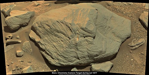
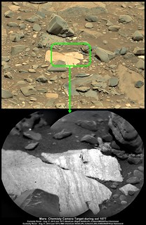
Sol 1077 R-MastCam mosaic, 8 images roughly stitched in MS ICE. This location was targeted by the laser (see LH side of the central rock) and the subject of a series RMI-ChemCam observation, some of which were posted here earlier by 'algorithm'
Click above preview to open the 1024 version or HERE for the full size version (4641 x 2338 pixels)
Click above preview to open the 1024 version or HERE for the full size version (4641 x 2338 pixels)
Nice Mosaic!
whats the chance they will ChemCam zap that little "pearl" jutting out....Id love to know its comp vs the material its encased in.
whats the chance they will ChemCam zap that little "pearl" jutting out....Id love to know its comp vs the material its encased in.
QUOTE (PaulH51 @ Aug 18 2015, 07:43 PM)
Sol 1077 R-MastCam mosaic, 8 images roughly stitched in MS ICE. This location was targeted by the laser (see LH side of the central rock) and the subject of a series RMI-ChemCam observation, some of which were posted here earlier by 'algorithm'
Interesting rock. It's obviously layered, thus implying a sedimentary rock of some kind. And yet the lower, less wind-smoothed portion looks like it has small vesicles in it. Since finely layered rock is less likely to be vesicular, I'd have to think that these are places where small grains have eroded out, or dropped out, of the rock. Either that, or the little holes are tiny craters left by energetic ejecta from nearby impacts.
Of course, I suppose it could be an example of a sedimentary rock that was partially melted via impact, thus forming vesicles. The distortion of the layering on the upper portion of the rock could also speak to partial remelting, too, I suppose.
-the other Doug
Of course, I suppose it could be an example of a sedimentary rock that was partially melted via impact, thus forming vesicles. The distortion of the layering on the upper portion of the rock could also speak to partial remelting, too, I suppose.
-the other Doug
Variations on the theme!
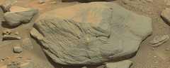
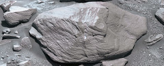
Another interesting 'Light Toned' Target for the RMI-ChemCam during sol 1077.
Full size version (1404 x 2164) LINK
Full size version (1404 x 2164) LINK
anaglyph sol 1074

QUOTE (eliBonora @ Aug 20 2015, 12:35 AM)
anaglyph sol 1074
Nailed it Eli
I always look to seeing your work here...Here is the sol 1078 'Drive Direction' L-MastCam, colour and contrast stretched to being out the wonderful detail of the geology to the South and South-West.
Full size version (5811 x 1427 pixels) LINK
We're moving again... but I'm afraid i will be unable to map anything for a few sols while travelling (currently on Hornby Island, BC) - not to worry, normal service will resume as soon as possible.
Phil
Phil
Looking NNW on sol 1078 a R-MastCam 4x2 Mosaic, colour and contrast stretched
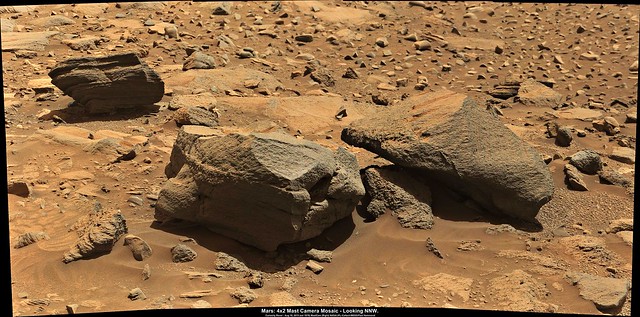
Link to full size (4563 x 2261) LINK
Also the latest USGS Mission Update Report from Ryan Anderson "Sols 1080-1081: Official New Selfie!" LINK
Link to full size (4563 x 2261) LINK
Also the latest USGS Mission Update Report from Ryan Anderson "Sols 1080-1081: Official New Selfie!" LINK
QUOTE
...On sol 1080, ChemCam has observations of the targets Red Lodge, Mowry, and Rosebud, with accompanying Mastcam images. Mastcam will also take a 19-frame stereo mosaic of a cliff dubbed Judith River. After the drive, we have our standard post-drive imaging, plus an active measurement with DAN. On sol 1081, since we wont have the data down yet to do targeted observations, we have a bunch of atmospheric monitoring with REMS, Navcam, Mastcam, and ChemCam. Were also planning a 360 degree Mastcam mosaic to take in our new surroundings and MARDI will take a picture of the ground under the rover....
Now that is a truly stunning vista. The 360 degree mast camera panorama (planned for sol 1081) promises to be a memorable image
yes, we're finally up where we can get some perspective on the rolling foothills once again
Click to view attachment Click to view attachment
Click to view attachment Click to view attachment
Curiosity Mission Update from Ken Herkenhoff : Sols 1082-1084: Nice View LINK
QUOTE
...On Sol 1082, ChemCam and Mastcam will observe Ravalli and a brighter rock dubbed "Sawtooth" before Mastcam acquires a 23x6 mosaic of the nice outcrops ahead. Mastcam and Navcam will look up at the sky at about the same time that the Mars Odyssey orbiter will be passing over, to compare results of observations from above and the surface. Then the arm will be deployed for contact science and the APXS placed on Ravalli for overnight integration. ChemCam and Mastcam will observe a couple more bright blocks on Sol 1083, named "Stonewall" and "Wolsey" before the rover drives toward the south. We'll then acquire the usual post-drive images and DAN active data. On the last sol (1084), ChemCam will take some calibration data and SAM will clean its scrubber in preparation for future measurement...
Great - here's a more map-like view of the same data, showing us on a rubbly ridge between depressions and outcrops.
Phil
Click to view attachment
Phil
Click to view attachment
Another drive on Sol 1083, 2 R-NavCam images acquired during the drive reveal some interesting shallow channels exposing light toned bedrock?
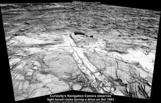
Full size (1860 x 1193) LINK
Full size (1860 x 1193) LINK
Coulple of Questions...
Anyone know if there is an acessible contour map that covers the ground between the curent location and Murray Buttes? Or even between the current location and the Clay and Hematite ridge?
In a recent curiosity video update JPL reported on the Lewis and Clark Trail, and showed a variety of possible paths as well as some limitations to its boundaries. Were those maps ever issued outside of the video?
Thanks in advance for any pointers. I realise that the actual path will depend on a number of factors, but it would be fun to try and visualise the next parts of the journey.
I will add the link to the video here....
There's a topo map here, but there are no contours or elevation scale. I've seen contour maps but only at much lower resolution.
Jan's pan in circular form:
Click to view attachment
We have come down off that rubble-covered ridge and now there's a sea of outcrop all around.
Phil
Click to view attachment
We have come down off that rubble-covered ridge and now there's a sea of outcrop all around.
Phil
What exciting terrain to explore. Hang together wheels  , firm sandy soil is yet a ways ahead.
, firm sandy soil is yet a ways ahead.
quite a bit of countour going on at the X-mark spot sol1083
Click to view attachment Click to view attachment
Click to view attachment Click to view attachment
QUOTE (fredk @ Aug 24 2015, 10:23 PM)
There's a topo map here
Many thanks, that's one I was not aware of
appreciate the feedback...Here's the latest Mission Update Report from Ken Herkenhoff for Sols 1085-1086: Rough road ahead : LINK
Edit : Sol 1083 'Drive Direction' left mast camera mosaic. Roughly stitched in MS ICE, colour and contrast stretched. Some interesting fracture filled veins in the distance, but maybe not close to our path... Time will tell. This may be a 'rough road' but it's sure to be scenic
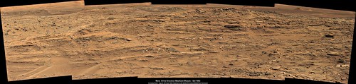
Full size (5768 x 1371) LINK
And the completed sol 1077 L-MastCam 22x2 Mosaic looking West.

Full size (23956 x 2330) LINK
looks like we finally can see a full view of Mt Sharp again on sol1081, AFAIK the last time we could see a relatively unobstructed view of at least the channel mouth was almost kilometer ago back in April on sol952 or maybe it was sol1047. Heres a quick n dirty ICE mashup taking liberties with the color.
Click to view attachment
Click to view attachment
This is a "lo-fi" version of our main content. To view the full version with more information, formatting and images, please click here.