Help - Search - Members - Calendar
Full Version: Exploring Mt Sharp north of the dunes - Part 1: Beyond Pahrump Hills
Unmanned Spaceflight.com > Mars & Missions > MSL
Pages: 1, 2, 3, 4, 5, 6, 7, 8, 9, 10, 11, 12, 13, 14, 15, 16, 17, 18, 19, 20
Ant103
Welcome everyone smile.gif

Looong time no panoramic stitching. I prefer to keep my own tempo on it wink.gif

So, I feel like to made the stitching of the last Sol 949 Navcam pan, and maybe Sol 950 will come.

tdemko
The close-up mosaic posted by PaullH1 reveals some fascinating details. The vein fills are complex, multi-generation features with evidence of several or repeated tensile fracturing events. There are anastomosing, en echelon, and hair-like network veins of several different mineral phases paired on either side of the center of the fracture. These are called stacked veins. The dark material seems to me to be mudstone country rock that was trapped between these sub-veins and subject to metasomatic alteration. When rocks are fractured in a tensile fashion, one possible result is the polygonal-to-crazed pattern we see at the exposure. The dominantly opening-mode dilation (with some evidence of slight shear) was filled by precipitation of minerals, presumably from the fluids that provided the hydraulic force that drove the crack tip propagation. Once rocks are fractured and veins emplaced, these discontinuities in the rock volume act as planes of weakness which localize subsequent brittle deformation. In general, the vein-host rock boundary is about half as strong (resistant to breakage when subject to the same stresses again) as the unfractured host rock. The relative strengths of the vein fill versus the altered and unaltered host rock controls the subsequent fracture morphology. If the vein material breaks first, a crack-seal pattern is the result, and there are mirrored pairs of older vein material split by the new fracture and filled with younger vein material. If the vein material is stronger than the host rock, the crack propagates in crazed fashion along the boundary, creating a crack-jump pattern, and the radiating/horse-tail hair-like fractures and veins. The crack can also deflect in and out of the host rock as it propagates along the interface, and the result are slices and slivers of host rock incorporated into the vein stack.

Although this paper (should be publicly available) concerns modeling of fractures and veins, it also has a nice summary and some illustrations of these concepts.

I'd also like to delicately point out that these fractures and veins show abundant evidence of formation and implacement at depth, in the subsurface. Although superficially similar to surficial features like mudcracks and polygonal fractures due to evaporite precipitation, the evidence points to a hydraulic fracturing origin and failure via overpressure or pressure differential.
Phil Stooke
Very pleased to see Ant103 back with us! For the 950 drive, here is the circular pan (from Jan's post, still missing a couple of frames) I used for locating the site on my map.

Phil

Click to view attachment


PS from tdemko's post above: " the evidence points to a hydraulic fracturing origin" - yikes, they're fracking on Mars now! Hope it doesn't mess up the groundwater.
Dig
Hello again Damia,
I also took a long time without posting any new panorama and was thinking maybe post some.
I think it makes little sense to publish all the same scene three or four times.
Jan is doing a good job and fast, very fast.
Arizona Dave
Regarding the veins and the fractures, the thing Im trying to understand is this:

These vein outcrops occur near the lower elevations of this large crater, Mt Sharp and the Rims being anywhere form 2 to 3.5 miles higher in elevation. Its now widely accepted that where Curiosity is exploring was under water far longer than previously estimated, and then that water slowly evaporated, leaving behind layered sedimentary rock layers and other tell-tale signs of long periods of a "shallow sea".

So, if these veins are the result of minerals precipitating under high pressure, then this would mean these veins formed under Several Kilometers of overburden...and now they are been exposed due to "erosion" the questions are:

a) Being near the bottom of Gale crate, rather than the top, where did the KM's of rock and overburden erode to? Erosion goes downhill, there isnt anywhere for KM's to have eroded to, The crater prevents excavation of sediment outside of the rim (thus all erosion remains inside the crater) - and

cool.gif 
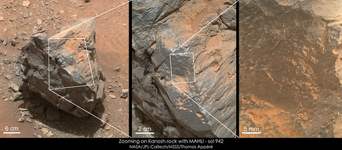
There is clear evidence of surface water at this location, and that it was under water at different shallow depths for perhaps billions of years...so, that situation in effect negates the overburden hypothesis, because again, the surface water action evidence is side-by-side with the veins.

Is it more possible this is non-pressure related, and more ancient heat/hydrothermal in nature?

If we accept Mars has been pretty dry for the last Billion years, then we are seeing something that had been roughly the same for a billion years...those flaky paper-thin wafer of rock resting in position where they are well above the surface show the wind load isnt enough to move them...so certainly not KM of overburden were removed simply by wind.

Im thinking Non Terrestrial erosion and mineralization mechanisms need to be considered...Mars has no Techtonic plates, and less water no matter how long it existing, and 2/5th the gravity, meaning erosion forces far less than earth...

Id love to hear some thesis on how these veins are so near the surface - thx.
erwan


Superbe Damia ! Et cela fait plaisir.
jvandriel
The Mastcam L view on Sol 949.

Jan van Driel

Click to view attachment
centsworth_II
QUOTE (Arizona Dave @ Apr 9 2015, 12:48 PM) *
...so certainly not KM of overburden were removed simply by wind.

Barring an error in my quick math, an average of 1mm removed per 100 years will lead to 10 km removed in a billion years.
Arizona Dave
QUOTE (centsworth_II @ Apr 9 2015, 11:56 AM) *
Barring an error in my quick math, an average of 1mm removed per 100 years will lead to 10 km removed in a billion years.


Yes, mathematically thats correct, but "Where" did the material go?

a) Not all overburden is "dust/sand" at least 50% of overburden would be hard rock and thus at least 50% of that overburden could not be moved by wind, thus it cannot be located outside of the crated, rocks dont roll uphill.

cool.gif Where does the 1mm/year data come from? 1mm/yr is a HUGE amount of material, and 1mm/yr assume 100% of that 1mm/yr was removed from the crater and deposited somewhere else...this brings up another interesting question: Does dust and sand only get removed from the crated to higher areas, or does dust also get blown in from outside the crater and deposited to Lower areas (dust and sand usually settles to lower/depressed areas over time)

c) WHERE did 1mm per year go? Only outside the crater?

d) at 1% of the earth's atmosphere, 100mph winds on mars would exert the force of a 1mph wind on earth...living in AZ for 20 years, dust storms simply dont happen in winds under 30-40 mph, and we certainly dont get 1mm of dust/sand per year removed or deposited in AZ...The dust in Mar's atmosphere is very fine dust, due to the lack of air compared to earth, so what mechanism not only eroded, but excavated all that material to Only Outside the crater?

Gale Crater itself is known to be as old or older than the sea/lake that they now know existed there. Mars' entire geology is entirely different than Earths...craters since almost he beginning of its forming still exist...while 99% of Earths craters and been sublimated via Plate Tectonics, and mass erosion.

Im really asking as serious question here, I dont see the mechanism to not only erode, but then Move the Kilometers of material away...not only that, but the clear signs of surface water, with the Veins Fracturing those surface water features means that the veins formed After? the water was lost, or at least When the Water was there...this them means Kilometers of Overburden were not only Deposited over the area to create the pressures required to form them, but then subsequently that same material was removed...

It had to come from somewhere and then it had to go somewhere...Or, the veins were formed under Low pressure/Surface conditions.

I think its absolutely fascinating whatever they are and however they formed...The paper thin wafer pieces all over are especially intriguing. Viewing these images in Streoscopic makes 2D photos seem bland.
Arizona Dave
On a little diff note:

Has anyone else noticed the lack of new full-res Raw images of late? Seems like they were putting up 20-40+ MAHLI and even more Pano full-res images until they hit Garden City...

I wonder if this because they are not taking as many pics, or something else?
ngunn
QUOTE (Arizona Dave @ Apr 9 2015, 06:48 PM) *
where did the KM's of rock and overburden erode to? Erosion goes downhill,


Well, perhaps some of the overburden could have been ice. Ice can 'erode' uphill - and in the case of Mars just keeps going that way.
mcaplinger
QUOTE (Arizona Dave @ Apr 9 2015, 01:03 PM) *
Has anyone else noticed the lack of new full-res Raw images of late? Seems like they were putting up 20-40+ MAHLI and even more Pano full-res images until they hit Garden City...

What do you mean by "full-res" and "raw"? Mastcam and MAHLI have no summing modes so all images are "full-res" technically. You can't tell the difference between lossless and JPEG return with MAHLI. Returning losslessly-compressed Mastcam images seems to have tailed off, is that what you mean? There are different users of Mastcam data and some would rather take more lossy images, some fewer lossless.
centsworth_II
QUOTE (Arizona Dave @ Apr 9 2015, 02:19 PM) *
...1mm/yr is a HUGE amount of material.....
My calculation has an average of 1mm per hundred years. And that's over a billion years. Three billion years may be a more realistic time frame. In which case a milli-meter every 300 years would do to remove 10km. Over the course of the rover missions, we've seen some pretty large gains of sand be moved around. The presence of large sand dunes on Mars depends on the ability of Mars wind to blow sand uphill. The rovers have seen fantastical shapes carved in rock by sand blasting. A lot can happen in a billion years. Changing wind patterns have buried craters and unburied them all over Mars.
Floyd
Arizona Dave-
On Earth erosion is mostly by water and stuff goes down hill. On Mars erosion (the last 3 billion years or so) is mostly by wind. Over this time frame, rocks break down to dust and wind carries it off, sometimes even from the bottoms of craters.
Arizona Dave
KM's of Ice certainly could produce the pressure necessary, but the issue with that is that the veins and fractures are through old pre-existing mudstone etc...the waters that formed many of the features has been evaluated to have come from "shallow" sea/lake...that lake then evaporated (over many repeated wet/dry periods over millions of years), so once the lake dried up, where did the water come from to form KM's deep of ice? Mars never had enough water to cover the entire surface, and so if it caem from millions of years worth of snow, why did the snow pile up there KMs deep? The Snow could not have accumulated over the entire surface KM's because there wasnt enough water...especially after the lakes and seas started drying.

Im just trying to build a picture of how that process looks, without Plate tectonics, the original Oceans/seas and lower elevations of Mars have essentially stayed the same for billions of years..Earth meanwhile has drastically changed continents and oceans in just the past 500 million years.

Is it possible there was some other geothermal process that could have caused these, maybe they are not even that old...possibly they are new compared to the exposed mudstones and layered sedimentary rocks?

Just throwing out some ideas, outside the box a little.

QUOTE (ngunn @ Apr 9 2015, 01:04 PM) *
Well, perhaps some of the overburden could have been ice. Ice can 'erode' uphill - and in the case of Mars just keeps going that way.

Arizona Dave
QUOTE (Floyd @ Apr 9 2015, 03:19 PM) *
Arizona Dave-
On Earth erosion is mostly by water and stuff goes down hill. On Mars erosion (the last 3 billion years or so) is mostly by wind. Over this time frame, rocks break down to dust and wind carries it off, sometimes even from the bottoms of craters.


True, current erosion on mars is caused by wind, more specifically dust particles carried by the wind basically sand-blasting other rocks.

The atmosphere being 1% has 1/100th the force of the wind on earth, there is no way around this. While on earth, winds can move pebbles and chunks of wood and blow over buildings at 100 and 200 and even 300 mph winds, on mars 300 mph wind will have the force to move what a 3mph wind on earth can move...perhaps 7 or 8 mph due to the gravitational weakness. So...on mars a 300 mph wind can move particles with as much force as an 8mph wind on earth, or move particles 1/100th the size at the same speed as winds on earth. Any way we cut it, wind erosion on mars is 1/100th what it would be on earth.

If KMs of material have been literally pulverized into talcum-powder dust by wind in Gale crater alone, and then transported, we should expect almost every KM+ tall feature on Mars to have been likewise blasted to dust (Mt Sharp for example), and dust layers of several KM deep covering almost the entire surface...what we see is quite drastically different. So why would the martian wind pick the lowest level of Gale Crate to blast into dust and export away while leaving Mt Sharp alone? We need a full process, not just one portion of it.

Needless to say, not all rocks get blasted away into dust...the dust blowing against a rock would need to be harder than the rock itself...we dont see a rock pile in Gale Crater, we see Bedrock features with boulders littered around...did 99.9% of the KM deep overburden really get sand-blasted while everything else remained intact?

Did Gale Crater happen AFTER the veins were formed deep underground, and exposed them from the impact, and then shallow seas filled Gale Crater? Or again, formed from other near-surface geologic process?
Arizona Dave
QUOTE (centsworth_II @ Apr 9 2015, 01:19 PM) *
My calculation has an average of 1mm per hundred years. And that's over a billion years. Three billion years may be a more realistic time frame. In which case a milli-meter every 300 years would do to remove 10km. Over the course of the rover missions, we've seen some pretty large gains of sand be moved around. The presence of large sand dunes on Mars depends on the ability of Mars wind to blow sand uphill. The rovers have seen fantastical shapes carved in rock by sand blasting. A lot can happen in a billion years. Changing wind patterns have buried craters and unburied them all over Mars.

Again, and not trying to argue, but scientifically speaking, how does 1mm per year get eroded? I have a stucco house, and I have 2" thick soft-concrete pavers for sidewalks, the house is 35 yrs old, the stucco is 1-1/2" thick, or 38mm...in 35 years the stucco has not eroded away, neither have my pavers which get hammered with AZ sandstorms, HEAVY rain laced with Sand and dust, etc. Simply put, rocks dont erode in a 1% atmosphere at 1 mm per year. Not even .1 mm per year. Water, when dripping on stone can "drill holes" over hundreds/thousands of years.

Now imagine an almost vacuum...where it takes 300mph wind to move grains of sand...but 300mph on mars happens how often? Its not as if there is a constant 100-300 mph wind on mars...thus how "Often" do "Erosional" event take place on Mars? Specifically at Gale Crate? 2 times, 10 time per year...then work that into the formula, and again, that is assuming that is the only mechanism...

So, again, if we accept the wind erosion theory, we must apply it over large portions of the Martian surface, and we need to find all that dust...KMs deep of it over large portions of the planet...what we see is opposite...scattered dunes, many with heavy grained sand, and LOTS of boulder and exposed bedrocks...Sririt, Opportunity and Curiosity all show this. HiRise and MRI images show this...we simply dont see a decimated planet covered in deep dust. We see dust storms, and dust accumulated on the rover...talcum fine dust. If wind erodes KMs deep of material on Mars, then we would find that accumulations of dust.

Also...NASA is now saying Gale Crated may have had water up until 1.5 or even 1B yrs ago...not 3.5B years...this would drastically change things as well.

So, Mars again...even if the overburden did erode away, why was did it selectively do so? Why Not eroded away entire Mt Sharp? Shat about all the Hard Rocks that must have been harder than the wind blown
Arizona Dave
QUOTE (mcaplinger @ Apr 9 2015, 01:11 PM) *
What do you mean by "full-res" and "raw"? Mastcam and MAHLI have no summing modes so all images are "full-res" technically. You can't tell the difference between lossless and JPEG return with MAHLI. Returning losslessly-compressed Mastcam images seems to have tailed off, is that what you mean? There are different users of Mastcam data and some would rather take more lossy images, some fewer lossless.

Here is the site I am accessing for images, maybe there is a better one? http://mars.jpl.nasa.gov/msl/multimedia/raw/index.cfm

A great majority of images on those links in the past 2 weeks have been thumbnails...before that a lot of the images were large...Im just hoping the rover isnt having problems...I know the wheels are deteriorating.

How far will this thing make it up Mt Sharp, or are they going to stay in the low-land valleys and alleys?
Arizona Dave
QUOTE (centsworth_II @ Apr 9 2015, 01:19 PM) *
My calculation has an average of 1mm per hundred years. And that's over a billion years. Three billion years may be a more realistic time frame. In which case a milli-meter every 300 years would do to remove 10km. Over the course of the rover missions, we've seen some pretty large gains of sand be moved around. The presence of large sand dunes on Mars depends on the ability of Mars wind to blow sand uphill. The rovers have seen fantastical shapes carved in rock by sand blasting. A lot can happen in a billion years. Changing wind patterns have buried craters and unburied them all over Mars.

Re-looking at what you said, maybe your suggesting its possible KM's worth of loose overburden was deposited over areas of Gale Crate, and then subsequently blown away ??

Interesting idea...also tilt of Mars Axis over time causing major wind patterns to change.

Also, I misread your 1mm relation...I read "per year", not 100 yrs...my apologies.
djellison
QUOTE (Arizona Dave @ Apr 9 2015, 03:34 PM) *
KM's worth of loose overburden was deposited over areas of Gale Crate, and then subsequently blown away ??

Interesting idea...


That is the prevailing hypothesis regarding the formation of Gale at this time.
elakdawalla
QUOTE (Arizona Dave @ Apr 9 2015, 04:30 PM) *
A great majority of images on those links in the past 2 weeks have been thumbnails...before that a lot of the images were large...Im just hoping the rover isnt having problems...I know the wheels are deteriorating.

Thumbnails are always sent down first. High-priority images necessary for planning are returned at full resolution very quickly, but science images may wait days or months (sometimes many months) before transmission. We are edging closer to conjunction and MRO was in safe mode last week, so there's a bit of a bottleneck with data transmission at the moment. Eventually, most of those thumbnails will be upgraded to full-res images.

The condition of the wheels (which has not been deteriorating rapidly) has nothing to do with imaging or data return.
serpens
Currently the environment on Mars is extremely benign but it would be a little silly to assess the formation of the current Mount Sharp topography based on current conditions. Gale is assessed to be between 3.6 to 4.1 billion years old and we know from Curiosity that when the areas she has traversed were laid down there was abundant surface water. Subaerial, not under ice. Looking at Mount Sharp we also know that the lower levels were water influenced and that following Mr Steno's wisdom, the layers should have covered the erosional end state explored by Curiosity to a significant depth. Lakes in Gale would possibly have been episodic but it would seem reasonable to assume that the formation of the lower layers of Mount Sharp occurred over a reasonably short geological timeframe. The increasing sulphates in the layers implies a change to an acidic, volcanic influenced environment and while as you say, Mars probably never developed tectonic plates, the formation of the Tharsis Bulge would have given the planet a real shakeup. If there was a northern ocean the effect on it would have been significant.

With respect to the veining, ice may or may not have provided a degree of compression and relaxation but given Tim Demko's indication that the fracturing and fill occurred at depth authigenic /mineralogic volume increases is probably the most likely cause of the veins, both here and also the larger examples higher up the mountain. Centsworth II gave a pretty fair indication of the cumulative effect of really minimal erosion over billions of year. Now extend that thinking to more rapid cycles of erosion and deposition in a reasonably high energy environment with the level of energy decreasing over billions of years until we get to the situation we see today. The upper, pretty much unconsolidated section of the mountain seems to reflect Kite's valley wind deposition concept but the lower levels, and Opportunity's observations, confirm lacustrine/fluvial deposition.

Where did all the eroded material go? Some contributed to the upper level of Mount Sharp. Since Gale is on the edge of the dichotomy much probably followed the gravitational gradient towards the northern lowlands.
Arizona Dave
QUOTE (djellison @ Apr 9 2015, 05:05 PM) *
That is the prevailing hypothesis regarding the formation of Gale at this time.

I have to admit, the time period involved with the known parameters would offset other arguments against hard erosion...This still presents some really interesting scenarios, because the fractures occur in pre-existing water-based bedrock...this means whatever process formed the veins had to involve water/hydrothermal processes under extreme pressure after that layer was originally formed, so now we are talking active processes happening after the base sea/lake evaporated, and the time involved in the deposition of overburden, and the "recent" wind-erosion.

In other words, in the last 30-25% of Mars' life, active geological (non weather-related) processes have been occurring!! So, the water that precipitated the mineralization was after the seas/lake dried up...

And perhaps 1/2B yrs ago, the atmosphere was far greater than current...plus NASA is saying water seas may have existed up until 1 to 1.2B yrs ago...a huge factor.

Whats next? its truly awe-inspiring what images we are getting, and in stereo-scopic is when the magic happens...I feel bad for ppl who cant see the stereoscopes...they are seeing a fraction of the overall scene. I tried describing it to a few ppl...they didnt "get" how much the veins and features are elevated above the surrounding material, 2D images just dont do it justice.

very cool indeed!
Arizona Dave
QUOTE (elakdawalla @ Apr 9 2015, 05:12 PM) *
Thumbnails are always sent down first. High-priority images necessary for planning are returned at full resolution very quickly, but science images may wait days or months (sometimes many months) before transmission. We are edging closer to conjunction and MRO was in safe mode last week, so there's a bit of a bottleneck with data transmission at the moment. Eventually, most of those thumbnails will be upgraded to full-res images.

The condition of the wheels (which has not been deteriorating rapidly) has nothing to do with imaging or data return.

Safe Mode answers most of my question, thank you. Do you have a link to the data that states the current/recent past status of curiosity? Ive looked and tried, and found nothing, its probably in plain sight and Im not seeing it...like most of the online bill paying portals lol :-)
neo56
Back to sol 942, I made a composite of two successive zooms on the surface of Kanosh rock by MAHLI camera (with scale):
PaulH51
My take on the sol 950 'drive direction' left mast camera mosaic (roughly stitched)
Dig
My return to UMSF.
Left Navcam Sol 950 Full Resolution.


Click image for full resolution.

My Curiosity Pinterest Board
Ant103
Sol 950 Navcam panoramic.

PaulH51
USGS Curiosity Mission Update for sol 951 (today) "10k" by Ryan Anderson.
Dig
To do something different.

Left Navcam and Left Mastcam (M-34) in single panorama.


Click image for full resolution.

My Curiosity Pinterest Board
hendric
QUOTE (Arizona Dave @ Apr 9 2015, 12:48 PM) *
a) Being near the bottom of Gale crate, rather than the top, where did the KM's of rock and overburden erode to? Erosion goes downhill, there isnt anywhere for KM's to have eroded to, The crater prevents excavation of sediment outside of the rim (thus all erosion remains inside the crater) - and


Deposition can go uphill. It's entirely possible that lower altitudes erode more because of thicker atmosphere, and the dust ends up at higher altitudes because the atmosphere cannot keep it afloat any more and the atmosphere cannot erode as effectively at altitude. Or the erosion at low altitudes puts dust into the air that ends up entrained in ice somewhere else. Larger grains are probably all local, but once they reach a size that they can be distributed via dust storms, they end up globally distributed.

QUOTE (Arizona Dave @ Apr 9 2015, 02:19 PM) *
a) Not all overburden is "dust/sand" at least 50% of overburden would be hard rock and thus at least 50% of that overburden could not be moved by wind, thus it cannot be located outside of the crated, rocks dont roll uphill.
d) at 1% of the earth's atmosphere, 100mph winds on mars would exert the force of a 1mph wind on earth...living in AZ for 20 years, dust storms simply dont happen in winds under 30-40 mph, and we certainly dont get 1mm of dust/sand per year removed or deposited in AZ...The dust in Mar's atmosphere is very fine dust, due to the lack of air compared to earth, so what mechanism not only eroded, but excavated all that material to Only Outside the crater?


Where is the 50% rock/dust number coming from?

I think the dryness on Mars allows for much finer dust - Az is a wet tropical paradise compared to the amount of water in the air on Mars. Also, moisture on Earth limits the minimum size of dust before it starts sticking together and falling out of the sky. The extreme dryness of Mars' atmosphere prevents small dust particles from cementing together.

http://en.wikipedia.org/wiki/Martian_soil#Atmospheric_dust

"Hard rock" I would guess is only true for the source basalts - once they have eroded into dust, and turned into sedimentary layers, I expect they are much softer than corresponding rock on Earth, due to lower gravity not compressing them as much and generally not as much water to cement grains together.

Topology of the crater could have influenced how the material interior hardened and was eroded away. It could affect where and how much water percolated upwards through the cracks generated by the impact, the size distribution of the dust depositions due to the initial crater walls and original central peak, and how wind erosion swirled around the crater. With the higher southern wall, it seems to me that winds blowing north would swirl over the wall, and erode the interior to the south of the central peak pretty effectively. I don't know if that's a prevailing direction of wind over the last 1Gy, but it would help explain why it looks that way.

Don't forget our view of Mars is a small snapshot in time of a very dynamic climatic system - with the huge axial tilt variability allowing for "permanent" ice caps at the equator. Lecture 1.20 gives an overview of what to expect over the range of axial tilts on Mars:

https://class.coursera.org/solarsystem-002/lecture

Having large ice caps at the equator probably causes some pretty intense & strange winds.
Arizona Dave
Ice Caps at the equator would indeed have extreme impacts on weather/climate...Thats a very interesting concept, and although I knew about its extreme changes in axism I never put 2 and 2 together...I wonder if the axis precession over the eons could also be a source of the "mass flooding" event that there is evidence of in so many of the different areas of Mars.

I just hope Curiosities wheels dont give out before it makes some more stunning discoveries like those veins...those things and the other features around them are awesome!

Thank you and everyone for patience...I really was trying to get a mental picture of the erosion processes, and now I do..maybe they are right, maybe something else, but definitely those ideas address the differences between terrestrial and martian erosion.

Also, someone else posted a link regarding Curiosities daily plan - THANK YOU! :-)
Ant103
How about a colorized version of the Sol 950 panorama ?

Here we go smile.gif

Phil Stooke
Nobody does that as well as you, Damia!

Phil

Dig
Excellent, Damia!
Phil Stooke
Just a word to our panorama compilers here. I love you all! You might think the duplication is unnecessary, and I'm not trying to over-burden the server... but every one is different - maybe left versus right cameras, or slight variations in geometry (try overlaying two apparently identical pans... they vary much more than you might think). So I personally am very pleased to see more than one version of a panorama. Then, of course, there are other ways of adding value: the Mastcam color overlay is nice, the full colorization is nice, highlighting ChemCam RMI targets might be another interesting addition.

Phil
charborob
Sol 951 navcam anaglyph of the curved outcrop that Phil Stooke referred to in the route map thread:
Click to view attachment
jvandriel
The Navcam L partial panoramic view on Sol 951.

Jan van Driel

Click to view attachment
Phil Stooke
Great! Here's a quick circular view to match with the map.

Phil

Click to view attachment
Floyd
So will de drive down the middle over the ripples, or take the right or left shoulder to avoid them?
algorithm
Sol 950/951 Front HazCam anaglyph

Click to view attachment

Assuming we have a full locking differential, it could be one toe in, one toe out!
atomoid
still gobbling up delicious vertically-tensile-fractured beef ice-cream sandwiches from sol948 MAHLIs
Click to view attachment Click to view attachment Click to view attachment
PaulH51
Another take on the sol 951 NavCam, using a few extra images (roughly stitched)


Plus the sol 952 USGS MSL Mission Update from Ken Herkenhoff :
jvandriel
and the complete Navcam L view on Sol 951.

Jan van Driel

Click to view attachment
PaulH51
ChemCam-RMI in telescopic mode captures "Joshua Tree" on Sol 951, April 10, 2015. Joe Knapp's 'Image Synth Page' suggests that Joshua Tree is in the upper right near the ridge line of this sol 950, April 09, 2015 NavCam image. I think I have located it, but I will await the mast camera images to be downlinked to be sure. Also included is a low resolution red/cyan anaglyph on the right side.


Note that the sol 952 end-of-drive NavCam are now in, looks like a 75.6m WSW drive smile.gif see Midnight Planets
jvandriel
The Navcam L view on Sol 952.

Jan van Driel

Click to view attachment

PaulH51
Looks like it was a wise choice to go around this potential sand trap... sol 951 left mast camera
jvandriel
Great view on Sol 952.

Jan van Driel

Click to view attachment

vjkane
QUOTE (jvandriel @ Apr 11 2015, 12:12 PM) *
Great view on Sol 952.

Still a long time before Curiosity plants the flag on the summit. This makes it real that she's still on just the lowest flanks.
Explorer1
There was no plan to ever go to the summit, originally? From orbit the upper slopes are more or less mundane material seen elsewhere, so of lower scientific value.
I'm sure the REMS team would love the higher altitudes, but there's a rover-load of instruments to think about...
This is a "lo-fi" version of our main content. To view the full version with more information, formatting and images, please click here.
Invision Power Board © 2001-2024 Invision Power Services, Inc.