I think that they will be delighted if they can get past the hematite ridge and investigate the phyllosilicate trough and the fan.
QUOTE (Explorer1 @ Apr 11 2015, 04:18 PM) 
There was no plan to ever go to the summit, originally?
Plan, no, but it's one of many options for a very extended mission. http://www.space.com/13723-nasa-rover-curi...ale-crater.html
QUOTE (serpens @ Apr 11 2015, 04:27 PM)
I think that they will be delighted if they can get past the hematite ridge and investigate the phyllosilicate trough and the fan.
I wouldn't be surprised to see the rover return to lower haunts eventually to confirm findings found on the way up.
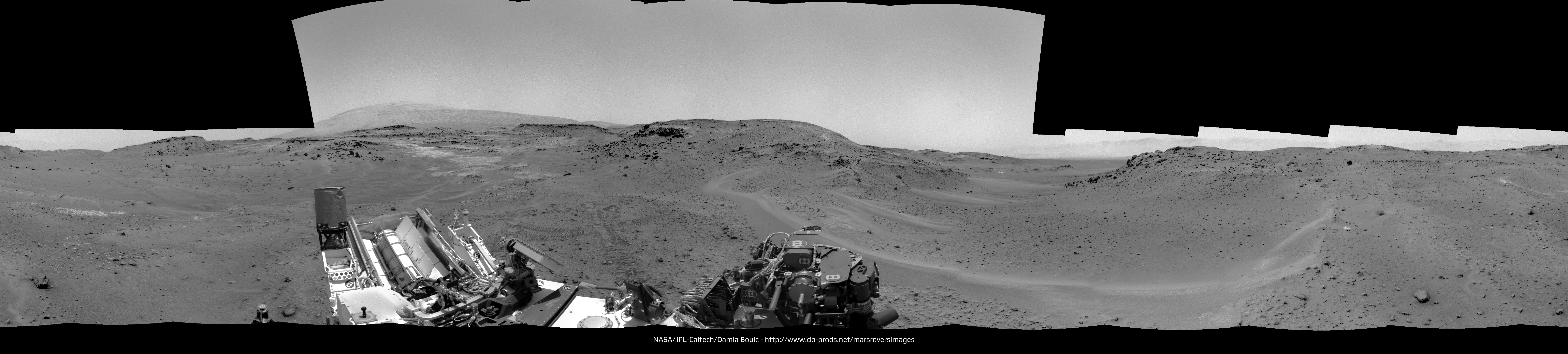
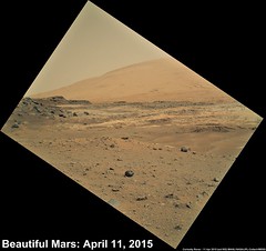
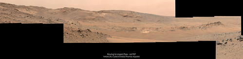
Sol 952 Navcam pan  The view toward Mount Sharp is lovely !

(Thank you for all your kind message next to my postcard :') )
The view toward Mount Sharp is lovely !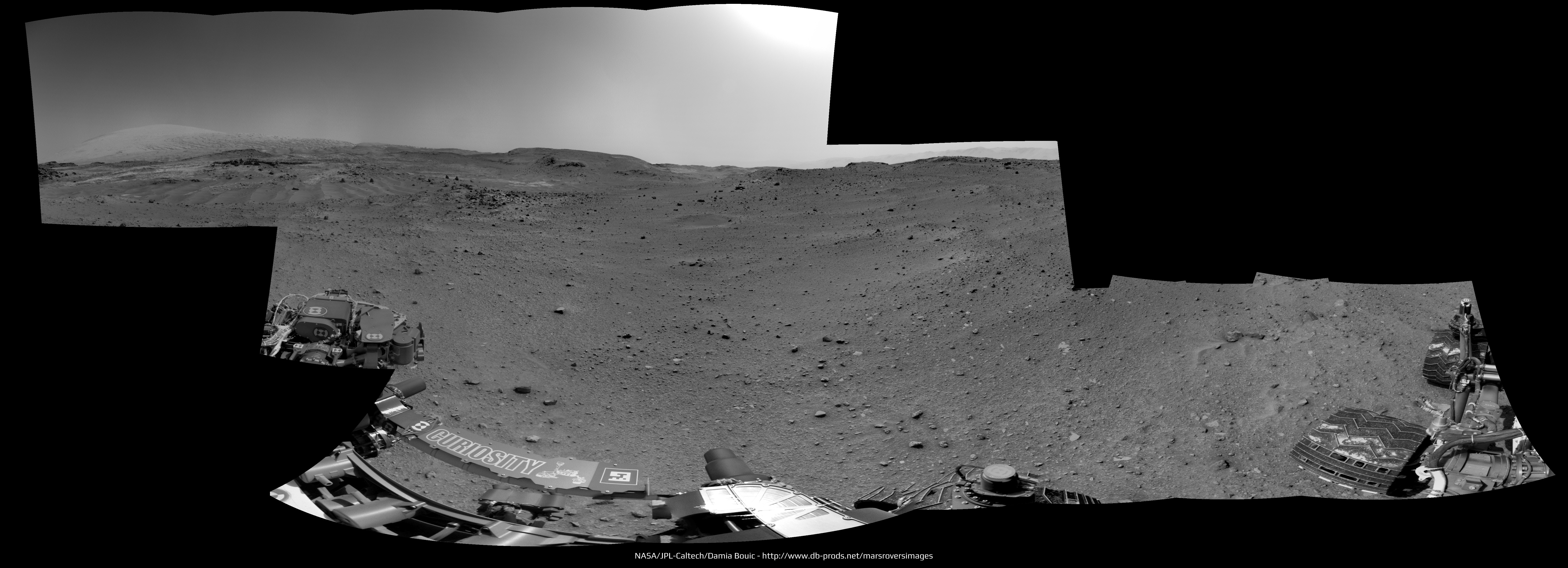
(Thank you for all your kind message next to my postcard :') )
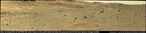
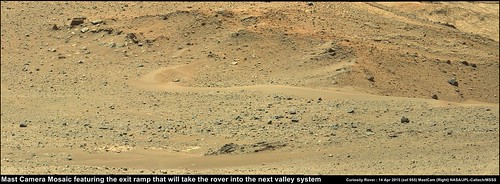
The end of sol 952 drive direction left mast camera mosaic that features what could be the exit ramp out of the bowl shaped depression (image center)
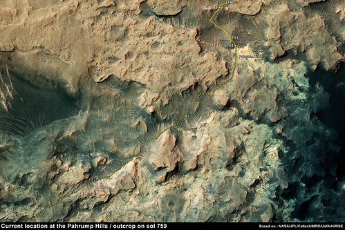
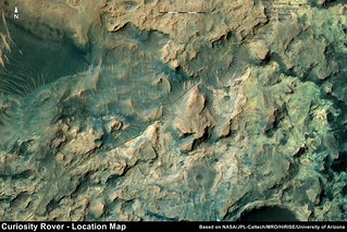
~200 hundred sols ago when we first arrived at the Pahrump Hills, I created this for an exercise to see if I could better define the possible path through the valley systems towards the mountain. I used a section one of Fred's fine location maps in addition to the extended mission path PIA 18780, but even using that hi-resolution version, the thick yellow line indicating the path masked many of the underlying features. Basically I just avoided the sandy ripples and what appeared to be steep inclines. I used a contour map produced by Joe Knapp for the first few sections of what we now know as Artists Drive, but I cant seem to find Joe's great map.
Now we have the sol 952 end-of-drive mast camera images, we can see what maybe the exit ramp into the next system, looks like I picked the wrong spot on my old plan Going to be an interesting journey...
Posted here to keep the Maps section for actual maps Flickr Page
Now we have the sol 952 end-of-drive mast camera images, we can see what maybe the exit ramp into the next system, looks like I picked the wrong spot on my old plan
Going to be an interesting journey...Posted here to keep the Maps section for actual maps Flickr Page
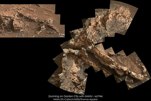
My take on MAHLI mosaic of Garden City veins on sol 946 in context with a MC34 mosaic taken on sol 929:
If you compare this sol 954 image:
http://www.midnightplanets.com/web/MSL/ima...CAM00309M_.html
With this 952 image:
http://www.midnightplanets.com/web/MSL/ima...CAM00353M_.html
you can see a little sample dump took place between them.
Phil
http://www.midnightplanets.com/web/MSL/ima...CAM00309M_.html
With this 952 image:
http://www.midnightplanets.com/web/MSL/ima...CAM00353M_.html
you can see a little sample dump took place between them.
Phil
The lack of images lately is driving me crazy...need more than thumbnails!!! Looks like they found some new interesting rock formations based on thumbnails.
The last vein of Garden City imaged by MAHLI, its context with a MC34 mosaic and scale for both images:

Removed full in line quote of previous post - Mod
Awesome Mosaic!
Those veins remind me of exposed surface tree roots that grow on grassy areas, like my backyard.
Very cool!
Awesome Mosaic!
Those veins remind me of exposed surface tree roots that grow on grassy areas, like my backyard.
Very cool!
Some really interesting rocks and small dunes from the NavCams on Sol 952.
http://mars.jpl.nasa.gov/msl/multimedia/ra...319M_&s=952
Some of the larger pics show a wide variety of rock types and shapes...like a debris flow-field I see in deserts out here.
http://mars.jpl.nasa.gov/msl/multimedia/ra...319M_&s=952
Some of the larger pics show a wide variety of rock types and shapes...like a debris flow-field I see in deserts out here.
That Sand with the sun lighting from directly behind is looks like its glowing...like some types of silica-sand on Earth. It might be the wavelength of light the NavCam is set to see...but Mt Sharp is glowing also...really neat.
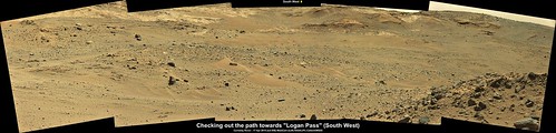
Based on Phil's latest update and using a crop from JPL's sol 951 location map, I have plotted a possible path from the current location into the next system.
The latest USGS Curiosity Mission Update shows a planned drive for sol 956 (~6 hours from now) Ryan indicates that the drive is scheduled for ~2 hours, so if all goes well, we may enter the next system. I am sure there are many other possible paths, this is just for fun only.
USGS Mission Update Sol 956: Mercury Transit
Thanks Paul. Nice to see the probable route on the detailed color map.
The first images of the drive on sol 956 are now available. I have used 4 L-NavCam images for this simple and roughly stitched mosaic, others will make far better versions which I look forward to seeing here....
We appear to be just in front of the entrance into the next system and it does looks inviting, ignoring the potential for sand traps
Maybe a short drive forward to better see what awaits us and to plan for the longer drives? Time will tell...
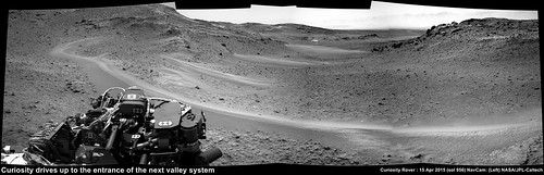
We appear to be just in front of the entrance into the next system and it does looks inviting, ignoring the potential for sand traps
Maybe a short drive forward to better see what awaits us and to plan for the longer drives? Time will tell...
A quick circular view of this site to show a different perspective. I expect we can go quite a way into the valley ahead on the next drive.
Phil
Click to view attachment
Phil
Click to view attachment
Sol 956 NRB post-drive semipan:

Edit: Sol 956 NRB 3-image mid-drive mosaic:

Edit: Sol 956 NRB 3-image mid-drive mosaic:
A moderately successful anaglyph version of the stitched Sol 956 Navcam mid-drive images:

My take on these two panoramic. What we can say about the view is "WOW !"


Nice Mosaics!
Looks like a lot of dust in air out a ways to the crater rim.
Also...new pics of rocks and soil today very interesting: http://mars.jpl.nasa.gov/msl/multimedia/ra..._DXXX&s=955
Notice the "crack" in the soil...freeze/thaw of brine possibly? Its obviously fairly recent. Also, lots of rounded rocks...more evidence for fast flowing water in past.
Fairly recent is right - that's due to work with the turret. Notice that several pebbles have been pushed into the soil, leading to cracks.
The "before" view (lower right corner):
http://mars.jpl.nasa.gov/msl-raw-images/ms...452E01_DXXX.jpg
shows that these features weren't there a few sols earlier.
The "before" view (lower right corner):
http://mars.jpl.nasa.gov/msl-raw-images/ms...452E01_DXXX.jpg
shows that these features weren't there a few sols earlier.
QUOTE (Arizona Dave @ Apr 15 2015, 11:08 AM)
Notice the "crack" in the soil...freeze/thaw of brine possibly?
Or simply imaging the area that the APXS was pressed into just a few minutes before
http://mars.jpl.nasa.gov/msl/multimedia/ra...206M_&s=955
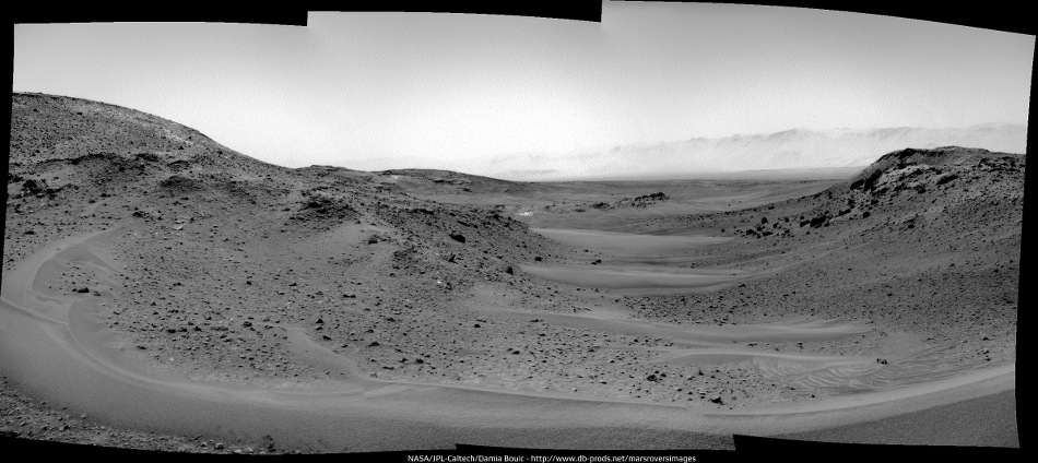
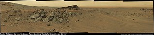
This is a circular version of Damia's sol 952 panorama, giving a nice view of the outcrops around this broad shallow depression. Mount St Mary appears to be the hilly area southeast of this rover location.
Phil
Click to view attachment
Phil
Click to view attachment
Sol 955 : 3-frame MC100 mosaic featuring the location where the rover stopped at the end of its sol 956 drive.
QUOTE (djellison @ Apr 15 2015, 12:54 PM)
Or simply imaging the area that the APXS was pressed into just a few minutes before
http://mars.jpl.nasa.gov/msl/multimedia/ra...206M_&s=955
http://mars.jpl.nasa.gov/msl/multimedia/ra...206M_&s=955
Yep, see it now, pebbled very clearly pushed down and to side. Dang, was hoping for one of those moments like when Opportunity uncovered what appeared to be ice/front under its tracks one time.
Has anyone else noticed more appearance of veins in some of the daily Navcam shots? Not close enough to say for sure, but appears possible some along side several of the valley walls scattered.
QUOTE (Arizona Dave @ Apr 15 2015, 04:54 PM)
like when Opportunity uncovered what appeared to be ice/front under its tracks one time.
Are you referring to when Spirit uncovered amorphous silica deposits near Home Plate?
http://photojournal.jpl.nasa.gov/catalog/PIA11758
..or perhaps the ice pack uncovered beneath Phoenix, or in the trench. as well as cryoturbation effects on the soil.
brings up the question that if there was indeed an epoch of permafrost, snowpack, or even glaciation during some Milankovitch cycle at these latitudes, could there still be any evidence visible or should have long since deflated away?
brings up the question that if there was indeed an epoch of permafrost, snowpack, or even glaciation during some Milankovitch cycle at these latitudes, could there still be any evidence visible or should have long since deflated away?
Would it be possible to create an anaglyph using the two sets of NavCam images (wide base-line)?
Updated MSL map, rotated 90 degrees to align with the NavCam view into the next section, hopefully this will makes it a little easier to identify some of the prominent features.

Latest USGS Mission Update from Ken Herkenhoff Sol 957: Limited Downlink
Latest USGS Mission Update from Ken Herkenhoff Sol 957: Limited Downlink
Sol 956 Navcam pan updated (see my previous post, instead of publish twice the same picture).
New images... we had a drive on sol 957. I'm not sure of the exact location yet but it looks like about 15 m roughly west, with the Navcam mini-pan looking northwest.
(Midnight planets reporting 60+ m west. I can't make that work. EDIT - ah - OK, now I'm making it work! OK, got it)
Phil
Click to view attachment
(Midnight planets reporting 60+ m west. I can't make that work. EDIT - ah - OK, now I'm making it work! OK, got it)
Phil
Click to view attachment
A try to stitch some of the Sol 957 NRBs:

Nice MAHLI from sol 952
JPL issued this "Curiosity's Position After 10 Kilometers" which gives us a new name for PHil's maps
JPL issued this "Curiosity's Position After 10 Kilometers" which gives us a new name for PHil's maps
Nice sunset images (thumbnails?) have come down.
QUOTE (charborob @ Apr 17 2015, 10:14 AM)
Nice sunset images (thumbnails?) have come down.
Those should be the 'Mercury transit of the sun images' I'll be watching for the full frames
Sol 958 preliminary NRB pano:

Left mast camera, looking West after the drive on sol 957
USGS Mission Update from Ryan Anderson "Sol 958: Officially 10k!"
USGS Mission Update from Ryan Anderson "Sol 958: Officially 10k!"
QUOTE (PaulH51 @ Apr 16 2015, 02:32 AM)
Would it be possible to create an anaglyph using the two sets of NavCam images (wide base-line)?
In some cases. Here an attempt with a cropped (and slightly rotated) Sol 957/958 NRB pair:
Click to view attachment
QUOTE (Gerald @ Apr 18 2015, 08:36 AM)
In some cases. Here an attempt with a cropped (and slightly rotated) Sol 957/958 NRB pair
Many thanks Gerald
I really appreciate your contributions across this forum.
MC100 picture and two successive MAHLI zoom on Telegraph Peak drill sample. Pictures taken on sol 954.

Sol 957 pre-drive right mastcam panorama:
Click to view attachment
Click to view attachment
Sol 958 : drive-direction left mast camera.
My take on the MC100 panorama taken on sol 957:
and MC34 mosaic of Libby outcrop:
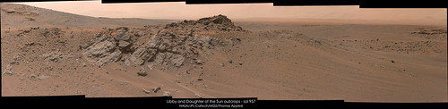
and MC34 mosaic of Libby outcrop:
This is a "lo-fi" version of our main content. To view the full version with more information, formatting and images, please click here.