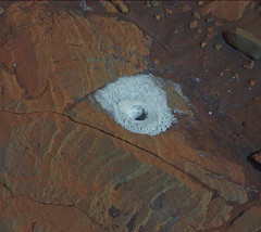
It's the left edge. There are ChemCam RMI images of it as well. Looks like a tear.
Phil

I have a sieve at home with an almost exact same issue, the sieve mesh has come away from the surrounding frame.
However, it still sieves flour just fine, and unless I decide to empty a whole pack of flour into it at once, I anticipate that it will continue to sieve flour for some time to come.
Having said that, my cakes don't suffer all that much from some lumpy flour getting int the mix, I suppose the problem for Curiosity instruments is somewhat more dire should larger grains ingress through the gap between sieve and frame.
Would that be a likely scenario? Who knows!?
Apparently, it's been that way since Sol 81 or earlier.
Here's a MASTCAM image that shows it on Sol 81.
http://mars.jpl.nasa.gov/msl-raw-images/ms...1000E1_DXXX.jpg
Here's a small crop of that Sol 81 MASTCAM image.
Click to view attachment
And here's an old mention of it from October of 2012.
http://www.planetary.org/multimedia/space-...edge-welds.html
Here's a MASTCAM image that shows it on Sol 81.
http://mars.jpl.nasa.gov/msl-raw-images/ms...1000E1_DXXX.jpg
Here's a small crop of that Sol 81 MASTCAM image.
Click to view attachment
And here's an old mention of it from October of 2012.
http://www.planetary.org/multimedia/space-...edge-welds.html
QUOTE (Phil Stooke @ Oct 15 2015, 06:25 PM) 
...... Looks like a tear.
Are you sure that is not accumulated dust?
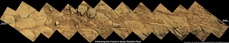
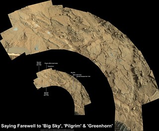
Here is a plan of activities near Greenhorn over the last few sols, with north roughly at the top.
Phil
Click to view attachment
Phil
Click to view attachment
Mission Update - By Lauren Edgar - Sol 1135: Sniffing the Martian Air LINK
QUOTE
The Sol 1134 mini-start hole on Pilgrim went well, as seen in the above MAHLI image. Side note: if that doesnt look like a hole to you, try rotating the image (the hole is illuminated from the lower left, but the human eye generally prefers to see sunlight coming from the upper half of the image).
Due to power restrictions, were waiting until the weekend plan to go for the full drill hole, but that means that today theres time for a SAM atmospheric observation and a targeted science block. The goal of the SAM activity is to look for methane, one Mars year after the previous high detections. So well let SAM take a big whiff to see if we can detect anything. I was on duty as GSTL today, and we filled the science block with several ChemCam and Mastcam observations. Were trying to look for variations in silica associated with the fracture zone that were drilling. We also planned several Mastcam images to look for changes in fine-grained deposits to evaluate local winds. Despite our power restrictions, planning has been going very smoothly today, and were looking forward to more time for science this weekend!
Due to power restrictions, were waiting until the weekend plan to go for the full drill hole, but that means that today theres time for a SAM atmospheric observation and a targeted science block. The goal of the SAM activity is to look for methane, one Mars year after the previous high detections. So well let SAM take a big whiff to see if we can detect anything. I was on duty as GSTL today, and we filled the science block with several ChemCam and Mastcam observations. Were trying to look for variations in silica associated with the fracture zone that were drilling. We also planned several Mastcam images to look for changes in fine-grained deposits to evaluate local winds. Despite our power restrictions, planning has been going very smoothly today, and were looking forward to more time for science this weekend!
Yeah, it's not a tear on the sieve. The photos they did were intentionally taken in geometry to get a specular reflection off the sieve, but I forget who told me that or why they were doing it exactly :| But I think it's just part of them monitoring long-term wear.
Sols 1136-1138: Drilling at Greenhorn. Mission Update from Lauren Edgar LINK
QUOTE
Unfortunately the Sol 1135 bundles were not uplinked due to a DSN issue, so the activities that we planned yesterday never made it onboard. However, that meant that Curiosity spent the day resting and recharging in time for a lot of great science this weekend.
Todays 3-sol plan will recover most of the activities that were planned for Sol 1135, in addition to the main activity of a full drill hole on the Greenhorn target. On the first sol, Curiosity will acquire several ChemCam and Mastcam observations on the targets Nisku, Skull Creek, Hawk Creek, and Opeche, to investigate the variability in silica associated with these fracture zones. Well also take several Mastcam images to look for changes in fine-grained deposits to evaluate local winds. Overnight, well use MAHLI to image the CheMin inlet in preparation for drilling activities. On the second sol, well go for the full drill hole on Greenhorn, followed by MAHLI imaging of the drill hole. The third sol consists of several environmental monitoring activities to assess the composition and opacity of the atmosphere. Well also squeeze in some Mastcam observations of the Big Sky dump pile and drill tailings using all of the camera filters. The only activity that we wont have time for is the SAM atmospheric methane detection, but were hoping to get that sometime next week. Ill be on duty again on Monday, so Im looking forward to seeing the results from the latest drill hole!
Todays 3-sol plan will recover most of the activities that were planned for Sol 1135, in addition to the main activity of a full drill hole on the Greenhorn target. On the first sol, Curiosity will acquire several ChemCam and Mastcam observations on the targets Nisku, Skull Creek, Hawk Creek, and Opeche, to investigate the variability in silica associated with these fracture zones. Well also take several Mastcam images to look for changes in fine-grained deposits to evaluate local winds. Overnight, well use MAHLI to image the CheMin inlet in preparation for drilling activities. On the second sol, well go for the full drill hole on Greenhorn, followed by MAHLI imaging of the drill hole. The third sol consists of several environmental monitoring activities to assess the composition and opacity of the atmosphere. Well also squeeze in some Mastcam observations of the Big Sky dump pile and drill tailings using all of the camera filters. The only activity that we wont have time for is the SAM atmospheric methane detection, but were hoping to get that sometime next week. Ill be on duty again on Monday, so Im looking forward to seeing the results from the latest drill hole!
Drilling the Mini-Start Hole at Pilgrim (Animation) - Sol 1134 R-HazCam (5 frames)
Small format preview (600x298)
Click to view attachment
Flickr (full size 1024 x 557 pixels) LINK
Imgur (full size 1024 x 557 pixels) LINK
Small format preview (600x298)
Click to view attachment
Flickr (full size 1024 x 557 pixels) LINK
Imgur (full size 1024 x 557 pixels) LINK
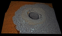
Sol 1137 drilling
Tiny-crop version:
Click to view attachment
Larger Crop (2.1 MiB)
Full Size (17.2 MiB)
Tiny-crop version:
Click to view attachment
Larger Crop (2.1 MiB)
Full Size (17.2 MiB)
2 of the ChemCam targets from Sol 1136 identified on 2 overlapping R-MastCam images. Targets located close to the fault near to the right rear wheel of the rover (RMI's re-sized to 60%)
Click to view attachment
Flickr Large 1024 x 868 LINK
Flickr Original 2058 x 1744 LINK
Imgur LINK
Click to view attachment
Flickr Large 1024 x 868 LINK
Flickr Original 2058 x 1744 LINK
Imgur LINK
Mission update from Lauren Edgar - Sol 1139: Another successful drill hole on Mars LINK
QUOTE
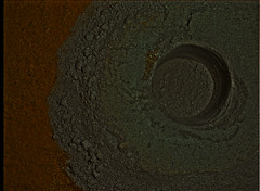
Over the weekend Curiosity drilled another hole on Mars at the Greenhorn target. Everything went smoothly and we have another beautiful sample to analyze! Todays plan is focused on transferring the sample to CheMin, followed by CheMin analysis of the drill sample. I was on duty as GSTL today, and we also planned several ChemCam and Mastcam observations of the drill hole and surrounding rocks. First well acquire a ChemCam passive observation of the drill tailings, and take a number of RMI images of the drill hole to help with ChemCam targeting of the drill hole tomorrow. Then well acquire ChemCam LIBS on the targets Gypsy, Tumbleweed, and Wrangle to assess the variability of silica associated with these fracture zones. Well also take a small Mastcam mosaic to document the ChemCam targets and the local topography, and a Mastcam and Navcam photometry experiment to characterize differences in lighting over the same region at different times of day. In the afternoon, the Greenhorn drill sample will be transferred, sieved, and dropped off to CheMin, and the sample will be analyzed by CheMin overnight. It will be interesting to see how this sample compares to the Big Sky target!
Nice anaglyph and great animations guys.... 
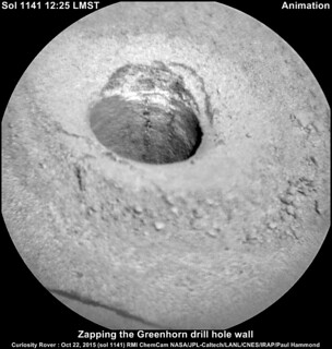
Latest from USGS: Zapping the drill hole wall - Mission Update from Ken Herkenhoff (Sol1140) LINK
EDIT
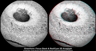
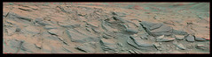
Greenhorn RMIs : Roughly stacked plus its 3D anaglyph, both created in Picolay
Flickr Original 2077 x 1117 LINK
Imgur Mirror : LINK
Latest from USGS: Zapping the drill hole wall - Mission Update from Ken Herkenhoff (Sol1140) LINK
QUOTE
The ChemCam RMI images of the drill hole planned yesterday were successfully acquired and received, and were used today to plan 2 parallel LIBS rasters down the hole. The additional LIBS raster should be useful in measuring variations in chemistry among individual sand grains and in detecting thin veins. ChemCam and Mastcam will also observe a target dubbed "Marshall" to see whether silica enrichment extends along other fractures near the rover. Finally the SAM methane experiment that was deferred due to an uplink problem last week is scheduled overnight between Sols 1140 and 1141. This experiment requires a significant amount of power, which will limit the activities that can be planned tomorrow.
EDIT
Greenhorn RMIs : Roughly stacked plus its 3D anaglyph, both created in Picolay
Flickr Original 2077 x 1117 LINK
Imgur Mirror : LINK
Recharging batteries: Mission Update: Sol 1141 From Ken Herkenhoff LINK
QUOTE
There was a problem processing the latest data from MSL at the Deep Space Network station that received it, but the data are now available and confirm that the Sol 1140 activities completed successfully. As expected, the batteries need to be recharged after the SAM methane experiment, so Sol 1141 activities are limited to a few remote sensing activities. ChemCam and Mastcam will observe the Greenhorn drill tailings and another bedrock target, called "Fort Conrad." Besides some recurring observations, that's it for the Sol 1141 plan! The rover's batteries should be nearly fully charged for Sol 1142 activities.
My take on Curiosity self-portait of sol 1126 at Big Sky:
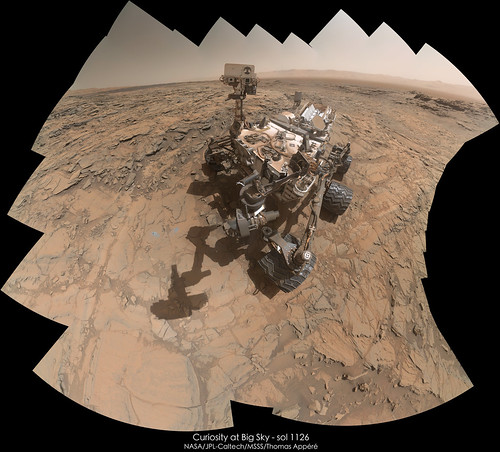
And with a sky added on Gimp :
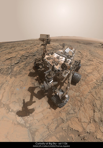
And with a sky added on Gimp :
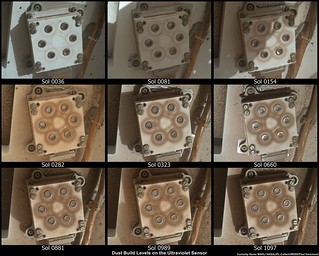
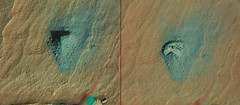
Here is an animation showing how dust is accumulating on Curiosity between sol 84 (1st selfie) and sol 1126 (last selfie):
Click to view attachment
Animation available in higher resolution here.
Click to view attachment
Animation available in higher resolution here.
Sol 1141 NavCam red/cyan anaglyph looking WNW into Cut Bank Valley
Click to view attachment
Flickr 980 x 1074 LINK
Imgur mirror LINK
Click to view attachment
Flickr 980 x 1074 LINK
Imgur mirror LINK
Sol 1132 1133 anaglyph
and holes compilation!
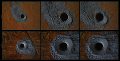
sol 1140
sol 1142
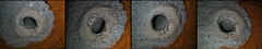
and holes compilation!
sol 1140
sol 1142
The pictures showing the latest efforts at 'The Martian Swiss Cheese Workshops' have arrived from Sol1142.
Click to view attachment
Slides and a Powerpoint presentation from all of the workshops will be given once the final workshop has taken place on the higher slopes of Mount Sharp. (Seats are limited)
Click to view attachment
Slides and a Powerpoint presentation from all of the workshops will be given once the final workshop has taken place on the higher slopes of Mount Sharp. (Seats are limited)
looking back
(Rear Hazcam in color sol 1143)
(Rear Hazcam in color sol 1143)
Another take on the L-MastCam mosaic with a few more images thrown in for good luck and an annotated inset thanks to Phil Stooke's earlier post.
Full size Flickr 8408 x 6929 LINK
Imgur mirror LINK
EDIT
Midnight Planets shows a drive of ~12.6m ENE on sol 1141, interesting direction takes the rover back towards Birdger Basin, maybe a small diversion to find a friendlier path? Link : http://www.midnightplanets.com/web/MSL/sol/01144.html
Full size Flickr 8408 x 6929 LINK
Imgur mirror LINK
EDIT
Midnight Planets shows a drive of ~12.6m ENE on sol 1141, interesting direction
takes the rover back towards Birdger Basin, maybe a small diversion to find a friendlier path? Link : http://www.midnightplanets.com/web/MSL/sol/01144.html
Sol 1134 & 1137
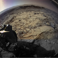
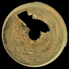
Thanks, Jan! Here it is in a circular view (it's rather distorted by the relief in the local outcrops).
Phil
Click to view attachment
Phil
Click to view attachment
End-of-drive L-MastCam mosaic sol 1144 looking back at Greenhorn and Big Sky. A taster for a full 360 L-MastCam pano
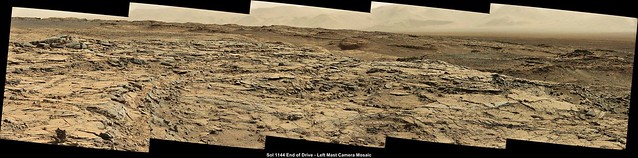
Flickr Original Size 5794 x 1434 pixels LINK
Imgur Mirror LINK
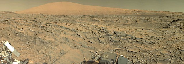
Mission Update from Ryan Anderson: Sol 1146-1147: A View of Meeteetse LINK
Flickr Original Size 5794 x 1434 pixels LINK
Imgur Mirror LINK
Mission Update from Ryan Anderson: Sol 1146-1147: A View of Meeteetse LINK
QUOTE
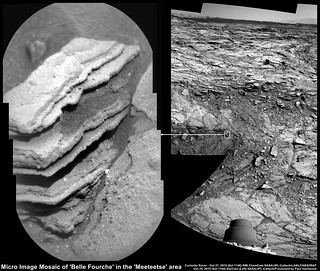
The weekend drive was successful, placing us nicely on an overlook of the Meeteetse area. The focus for Sol 1146 is to get some good color stereo images of the whole area, including Big Sky, Greenhorn, and Meeteetse. Mastcam will take a 16x3 mosaic of the Meeteetse area, plus a 12x1 right-eye mosaic of some nearby resistant ridges. It will also measure the amount of dust in the atmosphere by looking at the sun, and take a documentation image of the target Belle Fourche after ChemCam analyzes it. ChemCam also has a passive sky observation, where we use the ChemCam spectrometers to stare at the sky and measure the abundance of gases in the atmosphere.
On Sol 1147, the main activity is to deliver some of the material sampled at the Greenhorn drill hole to the SAM instrument, and then run a SAM evolved gas analysis and tunable laser spectrometer (EGA/TLS) experiment on the sample. This involves heating the sample gradually and measuring the gases that are produced as it breaks down.
On Sol 1147, the main activity is to deliver some of the material sampled at the Greenhorn drill hole to the SAM instrument, and then run a SAM evolved gas analysis and tunable laser spectrometer (EGA/TLS) experiment on the sample. This involves heating the sample gradually and measuring the gases that are produced as it breaks down.
QUOTE (jvandriel @ Oct 29 2015, 08:28 PM)
The Mastcam L panoramic view on Sol 1144.
Great processing Jan
Here is my rough and ready take using MS ICE, some stitching errors (as usual) but a great view of the mountain and the crater. Looking forward to seeing some other takes here..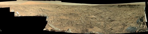
Flickr Original Size 30208 x 6961 pixels LINK
Imgur (down-sized during upload) LINK
NAVCAM travel animation for Sol 1144 is 28 frames.
Here's a small preview of the left NAVCAM's view:
Click to view attachment
And here is the full-size (512x256) stereo pair for Parallel and Cross-Eye viewing. Files sizes are 4.2 MiB each.
Here's a small preview of the left NAVCAM's view:
Click to view attachment
And here is the full-size (512x256) stereo pair for Parallel and Cross-Eye viewing. Files sizes are 4.2 MiB each.
With the drive on sol 1148, I've started a new thread. Onward to the dunes!
Anything up until the drive on sol 1148 (including the nice Mastcam stereo pan they took before the drive) should be here, anything after the sol 1148 drive over there.
Anything up until the drive on sol 1148 (including the nice Mastcam stereo pan they took before the drive) should be here, anything after the sol 1148 drive over there.
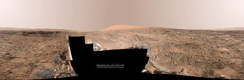
My take on the 360° panorama at Meeteeste area with pics of sols 1144 & 1148:
I'd like to fill the black gap in my last panorama where there are no photo of the rover. Does anyone know a recent sol when Curiosity has fully imaged its deck ?
QUOTE (neo56 @ Nov 1 2015, 03:39 AM)
Does anyone know a recent sol when Curiosity has fully imaged its deck ?
This has never been done with Mastcam.

I suppose in theory the gap could be filled with MAHLI self-portrait data, though that would be geometrically challenging.
I have the impression that occasionally Navcam is used to image the whole deck, but I don't have any tools that can conveniently figure out when this was done. I know it happened shortly after landing (see http://www.nasa.gov/mission_pages/msl/mult...a/pia16063.html ) We have occasionally tried to get a hybrid Mastcam/Navcam pan into the plan, but without science justification this is a tough sell.
Thanks Mike. I'll try to fill the gap with NavCam pictures. Andrew Bodrov already succeeded in using that technic.
I'll use NavCam pics taken on sol 1144 plus NavCam pics taken on sol 2, which cover completely the dock. Work in progress!
I'll use NavCam pics taken on sol 1144 plus NavCam pics taken on sol 2, which cover completely the dock. Work in progress!
QUOTE (neo56 @ Nov 1 2015, 09:49 AM)
Andrew Bodrov already succeeded in using that technic.
We've never been sure how that was made. It didn't appear until after the first MAHLI self-portrait, I don't think, so my presumption was that it used that for deck coverage. But I've never attempted that approach myself. I spent a fair amount of time with Hugin trying to make self-portrait mosaics with some of the gaps filled in with Mastcam images and ran out of patience with the tools. So it may be a matter of better tools and/or more patience
Some last mosaics
sol 1144
sol 1148 anagyph
sol 1144 sol 1148 horizon

sol 1144
sol 1148 anagyph
sol 1144 sol 1148 horizon
QUOTE (neo56 @ Nov 1 2015, 02:39 AM)
I'd like to fill the black gap in my last panorama where there are no photo of the rover. Does anyone know a recent sol when Curiosity has fully imaged its deck ?
QUOTE (mcaplinger @ Nov 1 2015, 07:42 AM)
This has never been done with Mastcam.
I suppose in theory the gap could be filled with MAHLI self-portrait data, though that would be geometrically challenging.
I suppose in theory the gap could be filled with MAHLI self-portrait data, though that would be geometrically challenging.
What Dr. Caplinger is not saying is that the Mastcam PI has forbidden the team from 'wasting' any more Mastcam pixels on the rover deck. Everyone on the mission who I have talked to about this except for the Mastcam PI agrees that it would be nice to have a Mastcam deck pan but that other battles are more important (and more winnable) than this one.
Indeed, it was MAHLI self-portrait data that Andrew Bodrov used for his panorama.
QUOTE (mcaplinger @ Nov 1 2015, 07:42 AM)
I have the impression that occasionally Navcam is used to image the whole deck, but I don't have any tools that can conveniently figure out when this was done. I know it happened shortly after landing (see http://www.nasa.gov/mission_pages/msl/mult...a/pia16063.html ) We have occasionally tried to get a hybrid Mastcam/Navcam pan into the plan, but without science justification this is a tough sell.
I have a very partial list of Navcam deck pans (will eventually have a complete list for the sols covered by my book, in the book). They include sols 134, 168, and 375, but those were in earlier (less dusty) days. The sol 375 one is notable because it was on the same sol as a Mastcam 360. I know there has been one more recently, but haven't systematically worked through sols after 413.
QUOTE (elakdawalla @ Nov 1 2015, 02:07 PM)
Everyone on the mission who I have talked to about this except for the Mastcam PI agrees that it would be nice to have a Mastcam deck pan...
Maybe, but attempts to get simultaneous Navcam/Mastcam coverage for merging and colorization have not been successful because of lack of science justification, so far as I know due to objections from people other than the PI. We can agree it would be nice, but there are lots of times when nice isn't a good enough reason.
You can be sure that we'll continue to push for it. Another option is to shoot a MAHLI pan from a position somewhere over the rover deck, although this hasn't been looked at by the rover planners and there may be constraints I'm not aware of that preclude it.
Going through the rover images, I found a section of the rover was imaged by Mastcam (accidentally? on purpose?) on sol 25 as part of a 360 1-tier panorama. It's not the whole rover by any means, but it's a start, including the Chemcam cal target, RTG, LGA, and most of the HGA. You can find PDS versions of the images here or here (you want the DRCL full frame images, which have an E in the third-to-last character; to convert them with IMG2PNG you also need to download labels).
QUOTE (elakdawalla @ Nov 4 2015, 01:09 PM)
Going through the rover images, I found a section of the rover was imaged by Mastcam Z [sic] (accidentally? on purpose?) on sol 25 as part of a 360 1-tier panorama.
Accidentally. We can command in many reference frames, both rover-relative and surface-relative, and if the rover orientation post-drive is not what we expected during planning, these sorts of things can happen. (Note that these images are focused on the stuff behind the rover, not on the rover itself.) There are some cases where the arm was imaged because it was in an unexpected pose, too.
I've tried to imagine a way in which the entire rover could be imaged by "accident" but I haven't come up with a plausible story. Yet.

QUOTE (mcaplinger @ Nov 4 2015, 02:12 PM)
I've tried to imagine a way in which the entire rover could be imaged by "accident" but I haven't come up with a plausible story. Yet.
Haha, I hope such an accident befalls you someday!
Here is a stitch from Sol 1087 MR...


Sol 1100 ML
Extended sky + minor foreground patches

...to the right of the image we see the climb toward Naukluft Plateau.
Extended sky + minor foreground patches
...to the right of the image we see the climb toward Naukluft Plateau.
This is a "lo-fi" version of our main content. To view the full version with more information, formatting and images, please click here.