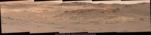
Sol 958 Navcam pan :
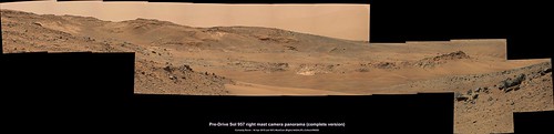
18 frames (complete?) version of the pre-drive right mast camera panorama looking WSW (some colour correction applied)
washed-out Mt. Sharp mini-pano sol960
Click to view attachment
Click to view attachment
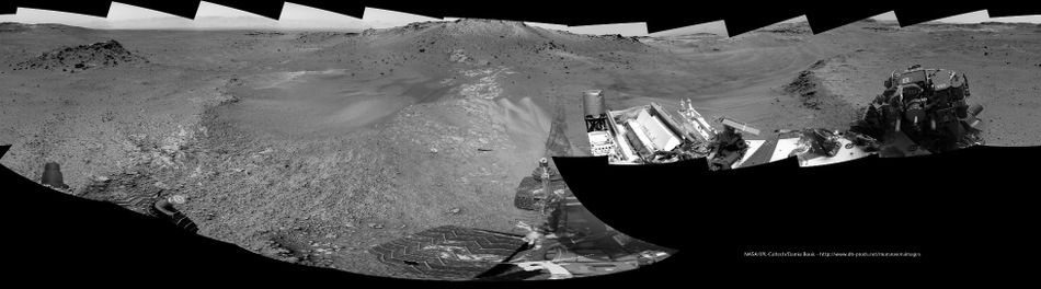
Sol 960 Drive direction left mast camera mosaic. Maybe considering going north of the butte and then dropping south into the pass to avoid driving through the sand on the south side of the butte? See Phil's latest map 

In this very interesting image, taken Sol 958, you can see two different sediments : a light-colored one (the most usual on which we roved for many Sols) and a dark-colored one, which seems to be fine-powdered (center) : maybe a preview of the dark-colored dunes to be seen later on the mission... Enjoy !
Click to view attachment
Click to view attachment

QUOTE (vikingmars @ Apr 21 2015, 01:07 AM) 
In this very interesting image, taken Sol 958, you can see two different sediments : a light-colored one (the most usual on which we roved for many Sols) and a dark-colored one, which seems to be fine-powdered (center) : maybe a preview of the dark-colored dunes to be seen later on the mission... Enjoy !
Ive been noticing a lot of the wide-variations in sand as well...some of the sand appears extremely bright. I wonder if part of this is due to longer-wavelength infrared being allowed to be filtered through?
it looks like this image was relatively overexposed in the Left pancam, is more equalized in the Right frame, nonetheless its bright enough to consider possibly sourced from erosion of (thanks Gerald) MgO=5.8% CaO=56.3% veins. dark sand ive always assumed basaltic but never read up on it.. (the stereo of this wasn't very satisfying so here just posting the R pano).
Click to view attachment
Click to view attachment
Another 4 sets of wheel check MAHLI images during sol 962
Animations of just one wheel (reduced to 1024 x 777) : Reddit Animation or Flickr Animation All Images Midnight Planets sol 962
Animations of just one wheel (reduced to 1024 x 777) : Reddit Animation or Flickr Animation All Images Midnight Planets sol 962
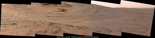
USGS Curiosity Mission Update from Lauren Edgar "Sol 963: Making a run for it" checking out "Logan's Run"
This is a circular view of Dig's sol 960 panorama. I was pretty far off with my last map, as I mistook one or two nearby features for others. I will fix the map after the next drive.
Phil
Click to view attachment
Phil
Click to view attachment
Mars Orbiter Sees Curiosity Rover in 'Artist's Drive' during sol 949 Photojournal page (PIA19392) - Full Res Image (annotated) - Unannotated Image
Simple merge/stack focus and red/cyan anaglyph using just 9 frames of the ChemCam-RMI target dubbed "Apple" acquired during Sol 963

Click image or this LINK
Click image or this LINK
QUOTE (atomoid @ Apr 21 2015, 02:46 PM)
it looks like this image[/url] was relatively overexposed in the Left pancam, is more equalized in the Right frame, nonetheless its bright enough to consider possibly sourced from erosion of (thanks Gerald) MgO=5.8% CaO=56.3% veins. dark sand ive always assumed basaltic but never read up on it.. (the stereo of this wasn't very satisfying so here just posting the R pano).
Do you know where the "Apple" is in relation to this pan? (Nice pano btw!, overexposed or not, it shows a LOT of different composition materials)
ADMIN: About 100 metres away in the opposite direction. Refer to the Drive Map.
USGS Curiosity Mission Update : Sols 964-965: Logans Run? Or just a short dash, from Lauren Edgar
Joe's drivelog has already been updated, but the map appears to contain a small offset to the south.
Very roughly stitched sol 963 post-drive left NavCam pano. The other available frames were giving huge stitching errors, so I omitted them.
Link to Flickr preview page
QUOTE
...Although we had planned a drive of up to 48 m towards Logans Run on Sol 963, the drive ended early after only 17 m due to the detection of a nearby hazard...
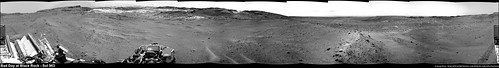
Edit : I guess we can now refer to sol 963 as "A Bad Day at Black Rock" (I guess only the older members will understand the attempted pun)Joe's drivelog has already been updated, but the map appears to contain a small offset to the south.
Very roughly stitched sol 963 post-drive left NavCam pano. The other available frames were giving huge stitching errors, so I omitted them.
Link to Flickr preview page
MAHLI at Sols 960, 963.

One of the post-drive L-MastCam mosaics from sol 963, this one looking south toward the entrance to Logan Pass (contrast stretched)

Lengthening Shadows - One hour before sunset on sol 964. Contrast stretched.


A very nice view! This is a circular version of it. You can see the big crater to the northwest - in HiRISE it shows up with dark drifts on its floor. Here we just see the northern and southern ridges which define it.
Phil
Click to view attachment
Phil
Click to view attachment
My take on MC34 panorama of sol 963. According to Phil's map, West Ridge is on the right and Logan Pass is between West Ridge and the background ridge.
Sol 964 MastCam Right thumbnails, Target "Blackrock", which stopped the Sol 963 drive:
Click to view attachment
Click to view attachment
Quick-and-dirty version of the Sol 964 post-drive Left Mastcam 5-image mosaic:

"According to Phil's map"
Yes... but unfortunately I don't know where that ridge actually is. I am waiting for a map with some names, or or other confrmation, to locate that and several other names.
Phil
Yes... but unfortunately I don't know where that ridge actually is. I am waiting for a map with some names, or or other confrmation, to locate that and several other names.
Phil
The last Mastcam L images of Sol 938 are down, debayered and stitched.
Jan van Driel
Click to view attachment
Jan van Driel
Click to view attachment
My take on MC34 and MC100 mosaic of Logan's Run on sol 964. High difference of luminosity between individual pictures made difficult to obtain homogeneous mosaics.

MC100 mosaic in high resolution here
MC100 mosaic in high resolution here
My take on the lovely view of sol 952:

Stunning!
Phil
Phil
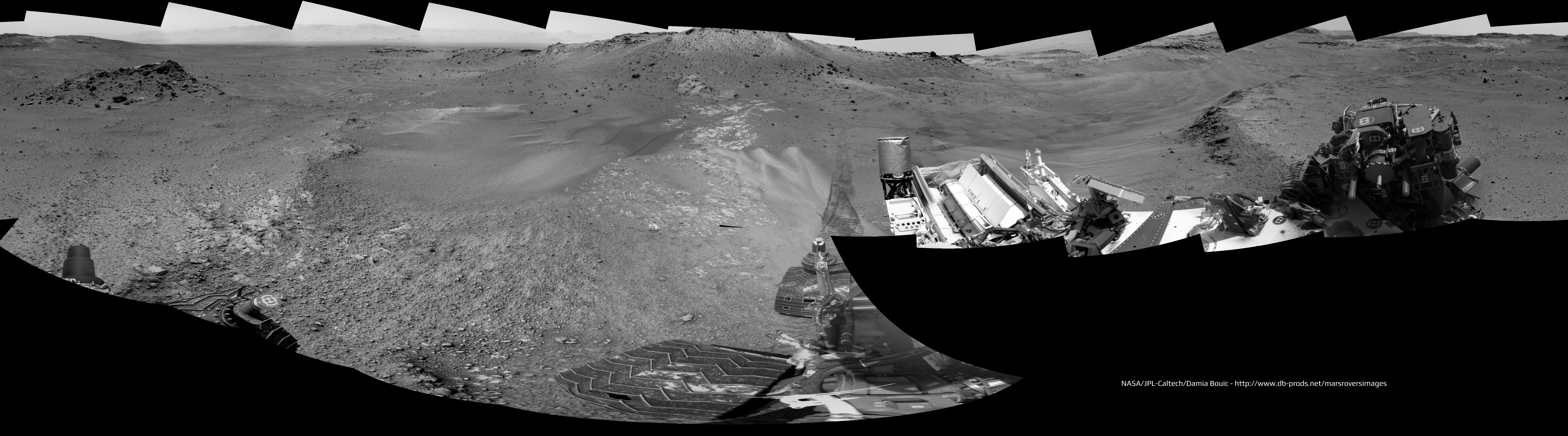
Sol 967 Right NavCam half-pan:

Wow. What an amazingly photogenic area. And Oppy is in one too. A real feast for the Mars-scape aesthetes out there ATM.
P
P
The sand (or dust) "sea" looks a bit "choppy" there.
The view on sol 952 with the right mastcam:
Click to view attachment
Click to view attachment
Sol 966 left mascam view:
Click to view attachment
Click to view attachment
Sol 967 NRB update:

Thanks, Gerald - here is a circular reprojection of it. Presumably these outcrops in front of us are Logan's Run... I confess I can't quite see what is so special about the area, but what do I know?
Phil
Click to view attachment
Phil
Click to view attachment
From the press release:
The unit characterized by a sequence of almost parallel small valleys and hills seems to be called 'Washboard unit'.
Between the lines I'm reading, that besides Logan Pass, also Logan's Run may be considered a candidate either as a contact/transition zone to the Washbord unit, or as an outcrop revealing the structure and composition of the Washboard unit. Investigating two similar sites improves the confidence in possible results (regarding the Washbord unit and its distinction).
QUOTE
At Logan Pass, we hope to investigate the relationship between the Murray formation and the Washboard unit, to help us understand the ancient depositional setting and how environmental conditions were changing. ... The ability to get to different sections of the rock record builds more confidence in your interpretation of each section.
The unit characterized by a sequence of almost parallel small valleys and hills seems to be called 'Washboard unit'.
Between the lines I'm reading, that besides Logan Pass, also Logan's Run may be considered a candidate either as a contact/transition zone to the Washbord unit, or as an outcrop revealing the structure and composition of the Washboard unit. Investigating two similar sites improves the confidence in possible results (regarding the Washbord unit and its distinction).
I get that... but why divert to Logan's Run rather than go straight to Logan Pass? It looks like it exposes less rather than more.
Phil
Phil
Just a wild guess: maybe they judged an outcrop to be more likely to be reachable by in-situ instruments?
Heres a crosseye for a section of those great sol952 pancam views. and a fun section of the recent sol828 downlinks as well
Click to view attachment Click to view attachment
(if too wide, open in SPM StereoPhotoMaker from IE context menu for easy pan/zoom)
Click to view attachment Click to view attachment
(if too wide, open in SPM StereoPhotoMaker from IE context menu for easy pan/zoom)
This is a "lo-fi" version of our main content. To view the full version with more information, formatting and images, please click here.