Help - Search - Members - Calendar
Full Version: Exploring Mt Sharp north of the dunes - Part 1: Beyond Pahrump Hills
Unmanned Spaceflight.com > Mars & Missions > MSL
Pages: 1, 2, 3, 4, 5, 6, 7, 8, 9, 10, 11, 12, 13, 14, 15, 16, 17, 18, 19, 20
fredk
QUOTE (Arizona Dave @ May 12 2015, 12:16 AM) *
Looking closer I can def see the disturbances from the rover, but not sure it looks like wheel tracks

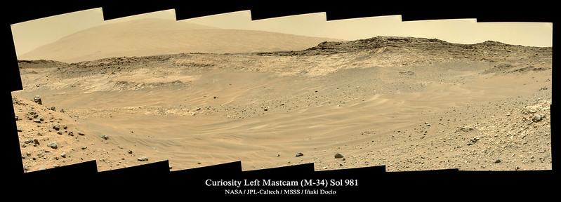
If you're trying to figure out what's going on in some mastcam view of the foreground, remember that there's normally good coverage of the foreground with navcam, normally on the sol they arrived at the site. So in this navcam view you can see the ground covered in the M100 view you linked to, and you can see by the tracks that indeed they did drive over those rocks:
http://mars.jpl.nasa.gov/msl-raw-images/pr...NCAM00354M_.JPG
Gladstoner
QUOTE (jccwrt @ May 11 2015, 06:18 PM) *
The contact kind of reminds me of a channel scour along I-40 in Tennessee (Link goes to Google Maps view). I've developed the unit descriptions based on the images coming down through Midnight Planets, so I think they're accurate but do feel free to correct me if I'm wrong. I'm working on a portion about the specific environment of deposition I've pulled out my old textbook and have been brushing up on lacustrine and alluvial settings. It's been a long time since sed/strat, so any suggestions for more specific stuff to look into would be appreciated. Thanks!

The presence of conglomerate in some spots does indicate fluvial clastics similar to your Tennessee example. Better yet, the strata at Gale are probably cyclical (like the Pennsylvanian beds in TN), so there could be several repeating sequences of fluvial conglomerate/sandstone, lacustrine beds, and possibly eolian sandstone.

A number of sedimentary sequences appear to outcrop in the lower slopes of Mount Sharp (though I'm not sure how close those are on the stratigraphic column with the rocks examined up close by the rover).
Arizona Dave
QUOTE (Zelenyikot @ May 11 2015, 04:22 PM) *
Funny ventifact at sol 978.


Yep, I see same thing right in the middle, those things are strange indeed.
MahFL
The Mars sunset was just on The Weather Channel smile.gif.
charborob
Magnificent view on sol 981:
Click to view attachment
PaulH51
My take on the 7x2 L-MastCam mosaic (processed version)

Full size (8053 x 2643) LINK

Plus the latest USGS MSL Mission Update from Ken Herkenhoff - Sol 983: More sand traps
Dig
Left Mastcam (M-34) Sol 981.


Click image for full resolution.

My Curiosity Pinterest Board . Flickr Gallery
jvandriel
The complete Mastcam L panoramic view on Sol 952.

Jan van Driel

Click to view attachment
jvandriel
The Mastcam L view on Sol 969.

Jan van Driel

Click to view attachment
jvandriel
and part of it taken on Sol 976.

Jan van Driel

Click to view attachment
atomoid
QUOTE (Arizona Dave @ May 11 2015, 06:51 PM) *
Yep, I see same thing right in the middle, those things are strange indeed.

yup, Zelenyikot's funny ventifact from sol978 was snapped on sol976 as well, hence a crude wider-baseline crosseye is derived.. ..couldnt resist the other interesting sol976 scenery coming down
Click to view attachment Click to view attachment Click to view attachment Click to view attachment
PaulH51
My take on the sol 975 R-MastCam mosaic of the outcrop at the base of Mt Shields.

Clicking image will open the 1024x435 pixel version, Full size is 15235 x 6471 pixels!
PaulH51
Quick and Dirty NavCam mosaic using the 11 available R-NavCam images from sol 983 LINK, may help to confirm the post drive location until the rest of the set comes in.
jvandriel
Sol 983 Navcam R view.

Jan van Driel

Click to view attachment
atomoid
experimental MARDI anaglyph sol739 just came down just for the heck of it
Click to view attachment
PaulH51
USGS Mission Update Sol 984: Slippery Sand, by Ken Herkenhoff: LINK
Slippery Sand causing more issues sad.gif
QUOTE
Despite efforts to avoid sandy areas, the Sol 983 drive stopped short when the rover detected that it was slipping too much

PaulH51
Sol 894 Partial End of Drive R-NavCam (6 frames) LINK
We can see where the rover backed out of the sand before going forward again... Looks like the rover is on an incline?
Phil Stooke
Yes - here's a hazcam view to show how we moved. You can see more of the tracks.

Phil

Click to view attachment

PS this traction issue is something that really has to be fixed for 2020!
PaulH51
QUOTE (Phil Stooke @ May 14 2015, 06:11 PM) *
Yes - here's a hazcam view to show how we moved. You can see more of the tracks.
PS this traction issue is something that really has to be fixed for 2020!

Nice detective work again Phil, I wonder what the slope angle of that section of the north wall is smile.gif
Fully agreed re traction issues for 2020. For MSL, maybe they can modify the drive software, so when it detects too much wheel slip, it then backs out and providing it has enough traction, it then tries a pre-loaded alternate route... (just thinking out loud)
elakdawalla
QUOTE (Phil Stooke @ May 14 2015, 03:11 AM) *
PS this traction issue is something that really has to be fixed for 2020!

It's really weird because traction is one thing they tested extensively on sand dunes with Scarecrow (see e.g. this blog and this JPL video). Clearly there is something we don't yet understand about how the physical properties of Martian dunes are different from Earth dunes.
jvandriel
The Navcam L view on Sol 984.

Jan van Driel

Click to view attachment
scalbers
QUOTE (elakdawalla @ May 14 2015, 02:59 PM) *
It's really weird because traction is one thing they tested extensively on sand dunes with Scarecrow (see e.g. this blog and this JPL video). Clearly there is something we don't yet understand about how the physical properties of Martian dunes are different from Earth dunes.

At first I was thinking that fine dust in the atmosphere would imply small grained sand dunes on Mars, then I read that the grain size of Martian dunes is typically about twice that on Earth. So I guess it wouldn't be due to a fine grained sand dune.
Phil Stooke
Alien aeolianologists (if there is such a thing) are always telling us not to call these things dunes - they are drifts or ripples, and I think they are dusty or silty rather than sandy. The real dunes are the big dark things between us and the mountain. So it may be that the wheels don't do well on these very fine sediments but would actually cope quite well on the big dunes.

Phil
ngunn
QUOTE (Phil Stooke @ May 14 2015, 10:01 PM) *
Alien aeolianologists (if there is such a thing) are always telling us not to call these things dunes - they are drifts or ripples,


I really hope that there is such a thing and that one of them will drop in to give us a proper account of the distinction in physical terms. The 'drifts' resemble dunes in shape and in their tendency to form periodic patterns. They are undoubtedly formed in a very similar way by surface modulated wind transport of grains. The grains are smaller, the necessary winds lighter, and they may be more slippery. Does that warrant a terminology barrier worth poilcing?
serpens
QUOTE (elakdawalla @ May 14 2015, 03:59 PM) *
It's really weird because traction is one thing they tested extensively on sand dunes with Scarecrow ..... Clearly there is something we don't yet understand about how the physical properties of Martian dunes are different from Earth dunes.


I would have thought that it would be pretty difficult to emulate the absolute dessication and armouring of Marian dunes/ripples as well as the particle compression due to the reduced gravity? So test results from Scarecrow would be indicative rather than absolute. Personally I think the design and slippage detection methodology is pretty good and sometimes when facing the unknown you just have to suck it and see and then adapt your operational approach. The bottom line seems to be stay away from dunes.

Ngunn, the transition between ripples and dunes is generally accepted as being a height of 0.075 metres. On Mars it is probably best to just think of ripples as small dunes - the distinction doesn't really seem all that important.
scalbers
On this wikipedia page (Deposition Section) there is some distinction made between aeolian ripples and dunes, in the layout of larger vs smaller particles from ridge to trough:

http://en.wikipedia.org/wiki/Aeolian_processes#Deposition

Gerald
QUOTE (Phil Stooke @ May 14 2015, 12:11 PM) *
PS this traction issue is something that really has to be fixed for 2020!

Of what I've seen of the preliminary 2020 rover design, the wheels will move forth and back during driving to overcome this issue, looks funny, a bit like crawling, but seems to work significantly better than the more rigid MSL design.
Gerald
QUOTE (serpens @ May 15 2015, 01:23 AM) *
The bottom line seems to be stay away from dunes.

They will stay away from the migrating dunes, at least, since otherwise the rover would run into the risk to be covered by the dune, in case of immobility for some period of time.
nprev
Considering the incredibly slow pace of geological change & aeolian surface processes on Mars I don't think that being overwhelmed by dunes is at all a risk.

As Spirit's demise showed, the problem with dunes is that there's no reliable way to gauge the depth of them prior to entering them. As Opportunity's struggle in Purgatory Dune showed, the mechanical properties of a given dune are also not readily obvious at a distance.

So, yeah: Avoiding them whenever possible seems eminently prudent.

djellison
QUOTE (Gerald @ May 14 2015, 04:33 PM) *
Of what I've seen of the preliminary 2020 rover design.....


Source for this?
Gerald
That's been a short video during a talk of someone who should know. I didn't try to find a weblink to the video.
Since the talk has been accessible for the public, the information should have been unclassified.

---

The mean migration rate of the dunes is estimated to 66 cm / Earth year in this paper.
The migration shouldn't be uniform, but may be accelerated during storms.
Take the scenario of a halt of a few weeks in the migration direction of the dune, coincident with a dust storm.
nprev
Thanks for the link to the paper. Note that it specifically concerns the dark dune field that was near MSL's landing site, which of course was studiously avoided for the reasons I previously described & is no longer a factor in MSL's traverse. That 66 cm/yr rate estimate is for a very localized area.

Re 2020 mission relevant design features, if you have a publicly accessible link for this data please post it in the appropriate topic. If you're not absolutely sure it's been publicly released, please don't refer to it.
PaulH51
USGS Mission Update Sol 985: High Tilt, by Ken Herkenhoff: LINK
QUOTE
Once again, excessive wheel slippage prevented MSL from driving as far as planned, so the tactical team decided to take a break from driving to allow various options to be studied in more detail. The rover is tilted 21 degrees, the highest tilt of the mission so far, on the flank of a small ridge......

elakdawalla
"Highest tilt of the mission" made me a little nervous but I was reading some Spirit mission history today (PDF), and it's worth remembering the kinds of slip and tilt the MERs have dealt with in the past, e.g.
QUOTE
Spirit flawlessly executed the VisOdom portion of the drive, placing it only 2m from its goal, but in a final cross-slope GO_TO_WAYPOINT it encountered the slope-related bug, executing several erroneous movements and sliding away from the goal. Several sols of high-slip driving--over 100% slip in one case with tilts up to 30 degrees--were required to reach our position atop Clovis. Once on Clovis, we performed extensive instrument placements on the outcrop and acquired the "Cahokia" panorama...
Curiosity should be able to handle much more difficult conditions than she's had to face before.

(I would like to see less slip on these sand drifts, though.)
PaulH51
Sol 984 : ChemCam observations of a nearby rock called "Una" to test the newly-installed ChemCam auto-focus software

Full size (3116 x 1139) LINK
Dig
Left Navcam Sol 984


Click image for full resolution.

My Curiosity Pinterest Board . Flickr Gallery
Gerald
QUOTE (elakdawalla @ May 15 2015, 07:08 AM) *
"Highest tilt of the mission" made me a little nervous ...
Curiosity should be able to handle much more difficult conditions than she's had to face before.
...

The thing making me feel a little uncomfortable is less the slope taken allone, but the very soft-appearing ground, leading to a possible risk to sink in at the downslope side.
It's certainly a good decision to first analyse the current state.
PaulH51
The left mast camera mosaic from sol 984 (adjusted colours)

Full size (5996 x 1710) LINK
blake
QUOTE (Gerald @ May 14 2015, 09:51 PM) *
That's been a short video during a talk of someone who should know. I didn't try to find a weblink to the video.


I spent two hours last night googling around, and fast forwarded through the few Mars 2020 telecons on YouTube but was unable to find anything on this topic. If it is in public domain, could you give a little more of a hint?

On a separate note, I did find an interesting video of Honeybee's development of the drilling, sample acquisition, and caching system:
http://www.unmannedspaceflight.com/index.php?showtopic=8016
hendric
Have we seen duricrust type features here in Gale? Perhaps it is drier here and the particles don't stick together as well as we expect, leading to slippage.
algorithm
A view of the drifts/ripples from Sol984 as an anaglyph


Click to view attachment
algorithm
The FHaz view from Sol985


Click to view attachment
Gerald
QUOTE (blake @ May 15 2015, 03:38 PM) *
I spent two hours last night googling around, and fast forwarded through the few Mars 2020 telecons on YouTube but was unable to find anything on this topic. If it is in public domain, could you give a little more of a hint?

I tried to track back the source, but failed to find the video. The closest similarity is to the wheel walking approach I've linked to in the ExoMars thread.
I can't rule out confusion between the two rovers somewhere in the communication pipe, probably my fault.
nogal
I just came across this MSL update. Interesting to understand a bit more how the route's planning takes place.
Here is a link to the text and a direct one to the video: Curiosity Rover Report: Rover Road Trip

Fernando
PaulH51
USGS Mission Update Sol986: Finding a Path, by Ryan Anderson LINK
QUOTE
We’ve been having trouble with the path we originally wanted to take through the sand toward the interesting geology at “Mt. Stimson”, so in today’s plan we are going to take a careful look around to identify better routes......
PaulH51
986 post drive R-NavCam, used just 4 frames for a quick stitch, some data drop out in this batch, but looks like we are back on leveler ground smile.gif
Click to view attachment
Actionman
If they can make the Logan run more power too them. pia19398-main_mcam04234rs24b_annotated wheel.gif wheel.gif wheel.gif
PaulH51
Further tests with the ChemCam's new software (early images, more to come?) on target called Yellowjacket...
Phil Stooke
This is a reprojection of Dig's panorama from sol 984, to circular form:

Click to view attachment

And here's the path plotted on the panorama PaulH51 just linked to:

Click to view attachment
jvandriel
Here is the complete Navcam NL B panoramic view on Sol 983.

Jan van Driel

Click to view attachment
This is a "lo-fi" version of our main content. To view the full version with more information, formatting and images, please click here.
Invision Power Board © 2001-2024 Invision Power Services, Inc.