Here is Jan's pan in circular form to help visualize the area.
Phil
Click to view attachment
Some white grains? seen in front of the rover on sol 1085 (before the drive) in this R-MastCam mosaic
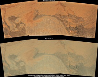
Full size LINK
Edit: Sol 1085 "DriveDirection" L-MastCam mosaic. I concur with Phil, looks like they could be heading towards the SE to find some easier driving conditions, then swing back to the SW.
Ful size LINK
Full size LINK
Edit: Sol 1085 "DriveDirection" L-MastCam mosaic. I concur with Phil, looks like they could be heading towards the SE to find some easier driving conditions, then swing back to the SW.
Ful size LINK
Huh. Shiny.
Short drive on sol 1087... Look ahead L-NavCam mosaic. At first I thought that the drive had terminated early, but could be that they wanted a closer look at the bright outcrop seen in the lower RH side?
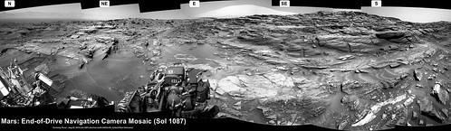
Full size (5008 x 1455) LINK
Full size (5008 x 1455) LINK
I still find these fascinating.
Click to view attachment
Click to view attachment
QUOTE (Herobrine @ Aug 28 2015, 12:07 AM) 
I still find these fascinating.
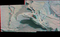
...especially when viewed in stereo, looks like a dump of rusting office supplies here, one 'pencil' is poking up sharply near the middle. The inordinately white veins perhaps sourced from or coevolved with larger light toned deposits along faults?, don't miss the tiny warbly vine complete with shadow at the top of the little crossbedded crosshatched stack remnant in the lower left quadrant of the second crosseye.. (also added an anaglyph of the first img and the warbly vine area)
Click to view attachment Click to view attachment Click to view attachment Click to view attachment
Curiosity Mission Update from Lauren Edgar "Sols 1089-1090: Stimson is Stunning" LINK
QUOTE
...Today were planning 2-sols for the weekend (Sunday is a soliday to allow Earth and Mars schedules to sync back up). One of the main activities on Sol 1089 is dropping off part of the Buckskin drill sample to SAM. Then well dump the Buckskin post-sieve sample, and analyze it with APXS. The plan also includes Mastcam and MAHLI imaging to document the dump pile. Sol 1090 consists of several ChemCam observations of the targets Fox Hills, OBriens Creek, and Bearpaw to investigate the bedrock and local alteration features. Well also acquire a large Mastcam mosaic to document the stratigraphy, and a Navcam deck pan for dust monitoring...
two last processing
sol 1081 panorama (too big 29032 x 1347!)

anaglyph sol 1085
sol 1081 panorama (too big 29032 x 1347!)
anaglyph sol 1085
QUOTE (atomoid @ Aug 29 2015, 12:07 AM)
one 'pencil' is poking up sharply near the middle. The inordinately white veins perhaps sourced from or coevolved with larger light toned deposits along faults?, don't miss the tiny warbly vine complete with shadow at the top of the little crossbedded crosshatched stack remnant in the lower left quadrant of the second crosseye.
Yikes, thanks for posting those, atomoid - definitely some of the craziest erosion remnants we've seen.
Edit: ML view of that "pencil":
No matching MR yet.
JPL have not updated their Curiosity traverse map for several drives, so I have taken the liberty of copying the the path and place names from Phil's latest update onto a cropped version of the last JPL issue (1074). I have also annotated the possible future paths that was shown in JPL's Rover recent video update. Note that they have shown two paths around 'Bridger Basin'...
Whichever path they eventually use, I think we will see some spectacular images.
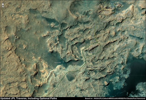
Full size (3650 x 2507) LINK
Whichever path they eventually use, I think we will see some spectacular images.
Full size (3650 x 2507) LINK
Here's the full Sol 1081 L NAVCAM panorama, with all frames downloaded to date.
Image is 29184x6826.
File size is 212 MiB.
Right-Click -> Save to download
For those that don't wish to download 1/5th+ of a gigabyte, here's a 1/8th size preview:
Click to view attachment
Image is 29184x6826.
File size is 212 MiB.
Right-Click -> Save to download
For those that don't wish to download 1/5th+ of a gigabyte, here's a 1/8th size preview:
Click to view attachment
Based on these Sol 1090 CHEMCAM images, I wasn't the only one who "still finds these fascinating".
(Click for GIF)
Click to view attachment
(Click for GIF)
Click to view attachment
Nice GIF of the RMI-ChemCam Herobrine  And no, you are not alone
Sol 1089: Discarded Powdered (Sieved) Rock Sample from 'Buckskin' in this MAHLI close-up. Scale bar added courtesy of Gerald's MAHLI Ruler
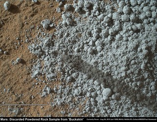
Original size (1584 x 1234) LINK
And no, you are not alone Sol 1089: Discarded Powdered (Sieved) Rock Sample from 'Buckskin' in this MAHLI close-up. Scale bar added courtesy of Gerald's MAHLI Ruler
Original size (1584 x 1234) LINK
Interesting. Are these little berries or just clumps? If berries, they would have to be tough enough to be drilled out of a softer matrix without getting broken up. I don't see any half berries.
QUOTE (Floyd @ Aug 31 2015, 09:44 PM)
Interesting. Are these little berries or just clumps?
I believe we are seeing 'Clumps'... This is the sieved sample, and has passed through the 150 micron sieve. We have seen other examples of highly cohesive sieved samples in the recent past. I don't know what height this sample was ejected from CHIMRA, but I suspect it was rather close to the ground, as this would reduce the odds of the sample being dispursed by a light wind, which could make measurement with the APXS very difficult.
I am unceasingly impressed by Curiosity's strength, precision, and stability.
Click to view attachment
(thumbnails recently downloaded from Sol 1089)
One of the greatest demonstrations of this that I can think of is when it's checking a full rotation of its wheels, like these images from Sol 1046.
(Click for GIF)
Click to view attachment + 3 other angles for MAHLI
and
(Click for GIF)
Click to view attachment + 4 other angles for MASTCAM
If you didn't know any better, you'd probably assume it left the camera there while it rolled forward, pausing 5 times to capture these images, then moved to capture a different wheel and did 5 more frames from that angle, and so on. In reality, it only performed a single revolution. After each increment, it moved the camera into position to snap a single frame, then moved the camera to several other locations to capture a frame from those angles as well, taking between 15-25 seconds for the camera to move to the next position, capture a frame, and move on. For each frame, it was able to return to the exact same position it had been in earlier, enabling an animation to create the illusion that the camera never moved.
This gets even more impressive when you realize that it didn't return to the same position relative to the rover body or chassis, but rather relative to the hub of the wheel it was imaging (you can see the rockers moving while the target wheel stays fixed in the frame).
Enjoyed those animations from Herobrine
Here is the latest Curiosity Mission Update from Ken Herkenhoff - 'Sol 1091: Lots of MAHLI Targets' LINK
Here is the latest Curiosity Mission Update from Ken Herkenhoff - 'Sol 1091: Lots of MAHLI Targets' LINK
QUOTE
...The team is very interested in the outcrop in front of the rover, so I had a very busy day as MAHLI/MARDI uplink lead today, even though we are planning just one sol. We planned in advance for MAHLI nighttime imaging of CheMin's inlet and MAHLI's calibration target (using white and UV LEDs), so those activities were ready to go this morning. But we had to prioritize and plan the details of observations of other contact science targets. Because the Sol 1089 MAHLI images and APXS placement were not perfectly centered on the Buckskin dump pile, our top priority is to repeat those observations with updated positioning. We planned MAHLI images of a target dubbed "Devon," which will also be measured by APXS. Many of the targets of interest are difficult to reach with the arm, so the rover planners requested relatively low-resolution MAHLI images of them to support planning of more contact science on Sol 1092. These targets were named "Pentagon," "Lebo," "Ivanhoe," and "Ledger," with Ledger being imaged in stereo by Mastcam because it is a candidate for brushing with the DRT. Finally, the APXS will be placed on the dump pile for overnight integration...
Well, if you like Curiosity GIFs, those last two, from Sol 1046, are just shrunken versions from a set of larger GIFs I made in July but never posted, one for each of the 9 camera angles, mentioned in my last post, of the Sol 1046 wheel checkout.
They're about 2 MiB each, though they're still only half the dimensions of the original frames (I love the quality MAHLI and MASTCAM provide).
From MAHLI:
http://i.imgur.com/TCNsW1J.gif
http://i.imgur.com/TFnOD4W.gif
http://i.imgur.com/ygKY0cJ.gif
http://i.imgur.com/9XiYPa4.gif
From MASTCAM:
http://i.imgur.com/vZOaJXG.gif
http://i.imgur.com/galBJXa.gif
http://i.imgur.com/EzxVUB6.gif
http://i.imgur.com/7D1RblZ.gif
http://i.imgur.com/Azgcw1X.gif
Edit: As long as I'm posting large GIFs, the full-size frames, corresponding to that Sol 1089 animation I posted, have been downlinked, so here's a larger, cleaner version:
http://i.imgur.com/NbL1q7y.gif
Ridiculously long and delicate "spoon" in suspension from sol 1089:
Click to view attachment
Click to view attachment
Crazy - are you sure you didn't make that up, Fredk? No wonder Mars is getting all this attention in the weirder media these days.
Phil
Phil
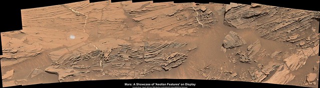
This whole area is full of interestingly eroded stuff.
Click to view attachment
There's a wider "suspended spoon" near the top-middle of that image (original is on the left).
Some of these thin overhangs are quite large; hopefully, Curiosity doesn't have the ground, that appeared solid, collapse beneath it.
Click to view attachment
There's a wider "suspended spoon" near the top-middle of that image (original is on the left).
Some of these thin overhangs are quite large; hopefully, Curiosity doesn't have the ground, that appeared solid, collapse beneath it.
ha! had the same soupspoon impression of those new sol1089 images!
Click to view attachment Click to view attachment
Click to view attachment Click to view attachment
I guess we should start looking for the knife and fork so we have the full set
Here is the latest plan: Curiosity Mission Update: by Lauren Edgar, Sol 1092: Stimson Contact LINK
Really good to see that they provided links to images of three of the science targets
Here is the latest plan: Curiosity Mission Update: by Lauren Edgar, Sol 1092: Stimson Contact LINK
Really good to see that they provided links to images of three of the science targets
QUOTE
...The Sol 1092 plan includes targeted remote sensing followed by more contact science. In the midday science block, well acquire ChemCam and Mastcam on the targets Rabbit Hills and Horseshoe Hills to investigate some of the alteration features seen here. Well also acquire some large Mastcam mosaics of the Williams area to investigate the sedimentary structures. The plan also includes a ChemCam RMI autofocus test, and a Navcam movie to monitor the atmosphere. In the afternoon, well acquire closer MAHLI imaging on Lebo, Ivanhoe, and Ledger, using the information we gained from the Sol 1091 MAHLI finder frames. Since "Ledger is a nice flat ledge, its also a good target for the DRT, so we can brush away the dust to expose a fresh surface. Then well place the APXS on Ledger for an overnight integration. Were in really early slide sols this week (meaning planning starts at 6am), but that hasnt stopped the team from putting together some very full plans!
Here's a circular view from Jan's recent panorama - it gives a good idea of the arrangement of outcrops here.
Phil
Click to view attachment
Phil
Click to view attachment
I put together a few "postcards" from Curiosity's end of drive NavCam images:
Curiosity Postcard sol 1083 by Justin Cowart, on Flickr
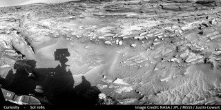
Curiosity Postcard - Sol 1085 by Justin Cowart, on Flickr
Curiosity Postcard - Sol 1087 by Justin Cowart, on Flickr
Curiosity Postcard sol 1083 by Justin Cowart, on Flickr
Curiosity Postcard - Sol 1085 by Justin Cowart, on Flickr
Curiosity Postcard - Sol 1087 by Justin Cowart, on Flickr
QUOTE (jccwrt @ Sep 3 2015, 08:56 AM)
I put together a few "postcards"....
Wonderful, hope you can make more of these in the future?
Here is the latest plan: Curiosity Mission Update: by Lauren Edgar: Sol 1093: Leaving the Williams area LINK
QUOTE
After successful contact science on the Stimson unit in the Williams area, its time to get back on the road. In todays plan well finish up a few activities at the Williams area, and then continue on our drive towards Bridger Basin and eventually the Bagnold Dunes.
Todays plan consists of ChemCam and Mastcam observations on the targets Interlake, Ledger, and Mackay Dome. Then well image the Ledger target using all of the Mastcam camera filters, and take another Mastcam clast survey image to look for any changes in the time that weve been here. Well also use Mastcam to look at the sun to measure the atmospheric opacity. Then well take a short drive and acquire post-drive imaging to help with targeting in tomorrows plan. Its exciting to be driving again, and Im sure well encounter some beautiful views as we continue to drive through this interesting terrain.
Todays plan consists of ChemCam and Mastcam observations on the targets Interlake, Ledger, and Mackay Dome. Then well image the Ledger target using all of the Mastcam camera filters, and take another Mastcam clast survey image to look for any changes in the time that weve been here. Well also use Mastcam to look at the sun to measure the atmospheric opacity. Then well take a short drive and acquire post-drive imaging to help with targeting in tomorrows plan. Its exciting to be driving again, and Im sure well encounter some beautiful views as we continue to drive through this interesting terrain.
Two of the Focus merged MAHLI's from the Stimson Unit, sol 1092. Both show a wide mix of grain sizes, and Ivanhoe bears few marks from the DRT brushes, suggesting it could be harder than some of the recent DRT targets. Thanks to Gerald for the MAHLI Ruler.
Ledger (post DRT) & Ivanhoe
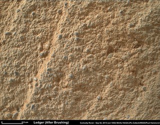
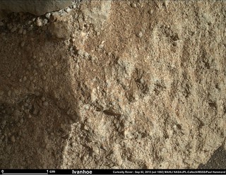
Ledger (post DRT) & Ivanhoe
QUOTE (Gerald @ Sep 3 2015, 04:20 PM)
The attempt has been successful:
Good to hear that was cleared
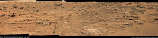
Some images from sol 984 came down today (anyway, I don't remember seeing them before). Fascinating outcrop:
Click to view attachment
Click to view attachment
Curiosity Rover Mission Update, from Lauren Edgar: Sol 1094: Turning in to Bridger Basin LINK
Edit
The sol 1093 Drive Direction L-MastCam mosaic... Rugged is an underestimate...
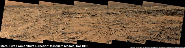
Original size (5875 x 1522) LINK
QUOTE
The drive on Sol 1093 went well, and Curiosity drove ~15 m towards Bridger Basin. In the Sol 1094 plan, well drive for ~30 m to round the turn into the basin, as we continue making our way through the Stimson unit. These rocks exhibit a lot of beautiful cross-bedding, as seen in the Sol 1093 Navcams.
Todays plan consists of ChemCam and Mastcam observations on the targets Whitewater and Whitefish, two targets that are within a bright, bleached area near a fracture. After a short drive, well take standard post-drive imaging to help with targeting in tomorrows plan. The plan also includes a ChemCam RMI autofocus test to assess temperature effects. Looking ahead, tomorrow will be a busy 4-sol plan to prepare for the long weekend!
Todays plan consists of ChemCam and Mastcam observations on the targets Whitewater and Whitefish, two targets that are within a bright, bleached area near a fracture. After a short drive, well take standard post-drive imaging to help with targeting in tomorrows plan. The plan also includes a ChemCam RMI autofocus test to assess temperature effects. Looking ahead, tomorrow will be a busy 4-sol plan to prepare for the long weekend!
Edit
The sol 1093 Drive Direction L-MastCam mosaic... Rugged is an underestimate...
Original size (5875 x 1522) LINK
QUOTE (atomoid @ Sep 1 2015, 05:14 PM)
ha! had the same soupspoon impression...
I love the side-by-side stereo images. For those of us who know how to view these -- cross your eyes and focus on the image in the middle -- it provides SO much more information about the landscape. Unfortunately, 10-15% of people don't have convergent vision and so can't do that.
QUOTE (Charles @ Sep 4 2015, 10:00 PM)
10-15% of people don't have convergent vision and so can't do that.
I fall in that 10-15 %
 But thankfully the red/cyan glasses do the trick with the great anaglyphs posted here:)
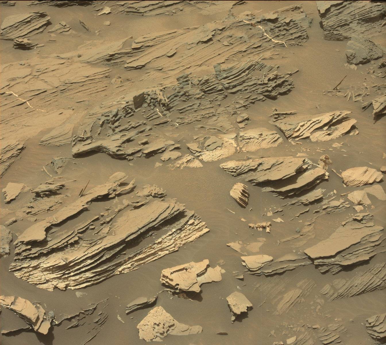
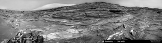
Last frame from the Sol 1087 MastCam pan of Williams came down. Beautiful set of cross-bedding.
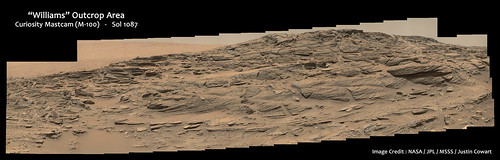
Sol 1087 Mastcam small by Justin Cowart, on Flickr
Sol 1087 Mastcam small by Justin Cowart, on Flickr
Here is Jan's panorama in circular form. The old jalopie will need a new set of shocks after this.
Phil
Click to view attachment
Phil
Click to view attachment
More strange erosion features (sol 1090):
Click to view attachment
Click to view attachment
I saw the "Spoon" and other ridiculously long features as well image by image and thought it might just be a play of light...but its not...those thigs are really "hanging" out there
that stereoscopic view is crazy awesome.
that stereoscopic view is crazy awesome.
Another reminder of what an incredibly benign environment Mars has nowdays.
Drive Direction L-MastCam, sol 1094. Driving conditions appear to be improving for the better...
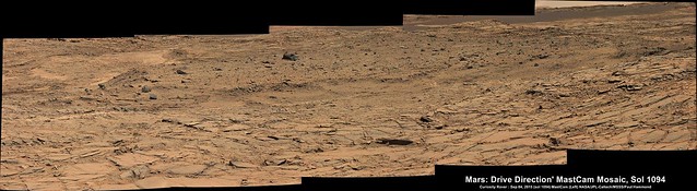
Original (5848 x 1602) LINK
Original (5848 x 1602) LINK
The last images are down and here is the complete Panorama taken on Sol 1081.
Jan van Driel
Click to view attachment
Jan van Driel
Click to view attachment
what are the white veins. im no scientician but im a rock hound and they look like gypsum...and if they are that indicates some profound implications about martian geology
They probably are; gypsum veins have been found by Oppy and Curiosity before. There was water percolation through bedrock in many places. Most of what we see is a lot older than most places on Earth, though; billions instead of millions. Erosion moves exceedingly slowly here.
This is a "lo-fi" version of our main content. To view the full version with more information, formatting and images, please click here.