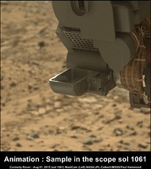
A first MAHLI iron oxides "litmus" test suggests some compositional similarity of "Buckskin" to "Telegraph Peak":
Click to view attachment
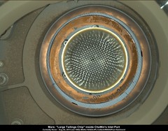
Nighttime MAHLI 1064, reveals what could be a large(ish) tailings chip, that has made its way into CHEMINs inlet post. Could be a stray chip fallen from the rover's turret or mast when the sample was dropped off in the instrument, or maybe there is an issue with the screen/filter inside CHIMRA or possibly what looks like a chip could be clump powdered material?
EDIT Added : Curiosity Mission Update, from Lauren Edgar Sol 1065: Last Call at Lion LINK
EDIT Added : Curiosity Mission Update, from Lauren Edgar Sol 1065: Last Call at Lion LINK
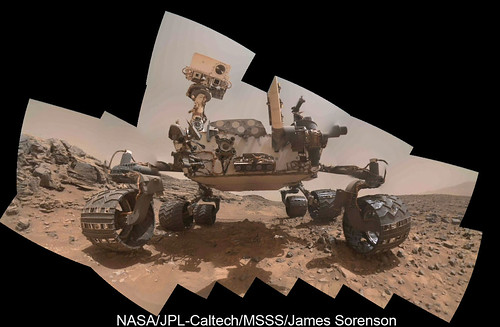
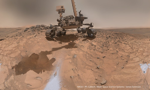
The thumbnails are only down right now, but here is the new selfie, and at an awesome new perspective. 
James,
That is some awesome mosaic-ing ...
Thanks for all your works!
That is some awesome mosaic-ing ...
Thanks for all your works!
Great work as usual James, looking forwards to your full size version, hope they don't keep us waiting too long for the full size frames
In the meantime Curiosity is heading back toward the Missoula outcrop...
Curiosity Mission Update, by Lauren Edgar: Sol 1066: Happy 3rd Anniversary on Mars! LINK
In the meantime Curiosity is heading back toward the Missoula outcrop...
Curiosity Mission Update, by Lauren Edgar: Sol 1066: Happy 3rd Anniversary on Mars! LINK
I took a crack at manually stitching together the latest "selfie" from the thumbnails yesterday. No reprojection or anything; just manually moving, scaling, and rotating layers in GIMP and smoothing layer transitions by soft erasing layer boundaries by hand. In case it weren't obvious, this is an asinine way to do it when there exist many software programs for stitching that take into account lens distortion and differences in camera position, but I guess I was in the mood to waste time (5 hours). Naturally, it's less accurate than James' stitch; the only reason I decided to post it (after deciding not to yesterday) is that I noticed a couple places on the rover where I was able to get a more continuous stitch.
Click to view attachment
Click to view attachment
QUOTE (Herobrine @ Aug 6 2015, 09:13 AM) 
I took a crack at manually stitching together the latest "selfie" from the thumbnails yesterday. No reprojection or anything; just manually moving, scaling, and rotating layers in GIMP and smoothing layer transitions by soft erasing layer boundaries by hand. In case it weren't obvious, this is an asinine way to do it when there exist many software programs for stitching that take into account lens distortion and differences in camera position, but I guess I was in the mood to waste time (5 hours).
On that thumbnail mosaic, that's pretty much what I did. Just manually positioned the thumbs in PTgui. For me it took about 20 minutes. No control points, with post processing in photoshop. When the fulls come down, they will be better aligned than thumbnail mosaic and I will use CP's.
Not all of the images are down but here is my view of the selfie taken on Sol 1065.
Jan van Driel
Click to view attachment
Jan van Driel
Click to view attachment
Still not all the images are down but a good impression for the complete one.
Jan van Driel
Click to view attachment
Jan van Driel
Click to view attachment
Curiosity Mission Update - Sol 1067: Bumping to Missoula
sound familiar? by Lauren Edgar LINK
QUOTE
Todays plan includes ChemCam and Mastcam observations of the targets Dixon and Doney to assess the chemistry in different parts of the Stimson unit. Well also acquire a Mastcam mosaic to characterize the terrain that DAN sampled.....
QUOTE (James Sorenson @ Aug 8 2015, 04:31 AM)
Happy Belated Anniversary Curiosity!
Epic......
Here's my generic rendering of light scattering on Mars in case it might help with filling in the sky?
http://laps.noaa.gov/albers/allsky/mars/al...gb_cyl_mars.gif
http://laps.noaa.gov/albers/allsky/mars/al...gb_cyl_mars.gif
Some wonderful 'Selfies' thanks to all....
As per Phil's new map we are back at Missoula, so here is the plan for the next three sols: Curiosity Mission Update, from Lauren Edgar: Sols 1068-1070: Back at Missoula LINK
Below is a few of the available post drive L-NavCams, (roughly stitched/cropped) indicating the position of Missoula in Marias Pass.

Link to full size version (2544 x 1435 pixels) LINK
Edit: The drive direction L-MastCam's from the same sol. that should take us along Marias Pass to the SW.
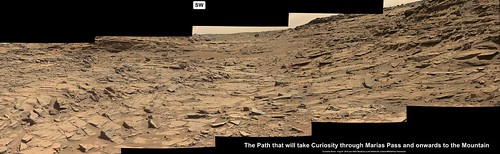
Original size 5793 x 1783 LINK
As per Phil's new map we are back at Missoula, so here is the plan for the next three sols: Curiosity Mission Update, from Lauren Edgar: Sols 1068-1070: Back at Missoula LINK
Below is a few of the available post drive L-NavCams, (roughly stitched/cropped) indicating the position of Missoula in Marias Pass.
Link to full size version (2544 x 1435 pixels) LINK
Edit: The drive direction L-MastCam's from the same sol. that should take us along Marias Pass to the SW.
Original size 5793 x 1783 LINK
In case you don't follow Damia's magnificent work, she has still her own way to see Curiosity selfies: http://www.db-prods.net/blog/2015/08/08/cu...s-ans-sur-mars/
QUOTE (scalbers @ Aug 7 2015, 05:46 PM)
Here's my generic rendering of light scattering on Mars that might help in filling in the sky?
http://laps.noaa.gov/albers/allsky/mars/al...gb_cyl_mars.gif
http://laps.noaa.gov/albers/allsky/mars/al...gb_cyl_mars.gif
I couldn't find text docs at your website, but on this "allsky" mars sunlight scattering map I'll presume that it's 180 deg in azimuth and 0-90 deg in altitude.
--Bill
Doh! That's right, 360. Dunno what I was thinking. ^^^
This map spans 360 degrees of azimuth and is in a cylindrical equidistant projection at 8 pixels per degree. It's kind of arbitrary, but one can suggest 180 azimuth is at the center. The important thing to check is the azimuth and altitude of the sun in each animation frame. One can then match up the frame having the same solar altitude with your case, then offset the longitudes to match. I have the sun at a same azimuth in each frame. The animation link (previous post) starts with the highest solar altitude of around 60 degrees (still frame shown below).
Click to view attachment
Click to view attachment
That looks so much like Earth's skies around the time of the Pinatubo eruption in 1991. In our region after a cold front moves through the skies are a deep crisp blue. A few months after Pinatubo, a bright 35-40 degree diameter halo with a tannish pearlescent luster was seen around the Sun and although the "90 degrees from the Sun" area was very much darker, it still had that dusty look. The skies got hazier closer to the ground. If you occluded the Sun with your thumb and looked at the halo, it was uncomfortably bright within a couple of degrees of the Sun. And this lasted for a couple of years after the eruption.
Anyway, your "allsky" map does indeed look exactly how that high-dusty sky looked.
--Bill
Anyway, your "allsky" map does indeed look exactly how that high-dusty sky looked.
--Bill
I have seen a similar dusty sky in central China with very little evidence of blue Rayleigh scattering. It's interesting that the darkest part appears to be about 45 degrees above the horizon, unlike a typical blue sky which is darkest at the zenith.
The ground in front of the rover and the edge of the Massoula Outcrop, L-MastCam, sol 1067
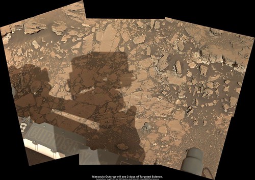
LINK to full size
LINK to full size
QUOTE (ngunn)
It's interesting that the darkest part appears to be about 45 degrees above the horizon, unlike a typical blue sky which is darkest at the zenith.
Yes, and this is just as Steve's modeled "allsky" image shows, also. Which is another measure of the validity (or would that be the veracity???) of his model.--Bill
Yes it's interesting to consider the similarity with analogues on Earth. I will say that even the Rayleigh Scattering can have a minimum brightness offset from the zenith, particularly when the sun is very high up as in this example. There is usually some Mie scattering mixed in to accentuate this - even if just a slight haze is present. A reasonable Earth analogue might be a bit of a hybrid of the volcanic and dust storm examples. Mars is a bit unique perhaps, in having dust in a deeper layer coming down to the surface, and I believe somewhat (though not very) small particle sizes. These sizes are near the wavelength of light. The best Earth analogue would be the rare "Blue Moon" type of event where the Moon (or Sun) really turns blue (rather than the recently popular calendar meaning).
Maybe China is a good example with some of the yellow dust there? Or this one from Sydney.
There's more general discussion in The Martian Sky thread.
Maybe China is a good example with some of the yellow dust there? Or this one from Sydney.
There's more general discussion in The Martian Sky thread.
Little dent in the soil just left of centre of this frame:
Click to view attachment
Might be due to a bit of a cavity underneath the soil. But I can't help but wonder if it's the result of a pebble coming off the slope above and bouncing. No sign of other bounces in the wider navcam frame.
Click to view attachment
Might be due to a bit of a cavity underneath the soil. But I can't help but wonder if it's the result of a pebble coming off the slope above and bouncing. No sign of other bounces in the wider navcam frame.
Interesting puzzle.
First step would be to check, whether there has been a contact with the rover.
If my eyes don't fool me, there seems to be a rim around the dent. This would reduce the likelihood of a tiny sinkhole.
Then there are two kinds of impacts, either kind of a local rockfall, or of a tiny secondary meteorite impact, with the impactor hidden within the dust/silt.
Some old remnants of landslides, mainly to the right seem to be present.
Interesting would be a small gas eruption. This could cause a similar craterlet with ejecta triggering a small landslide.
Edit: LIBS could cause a similar craterlet, but if so, I didn't find an according ChemCam image.
There are no chemcam shots of that patch of soil, and the navcam frame makes it clear no wheels came anywhere close to that patch, so I think we can rule out contact by the rover.
I also noticed the raised rim, which I agree makes a cavity/sinkhole less likely. Given that that is on a pretty steep slope, I think a rockfall is much more likely than craters or gas - we haven't seen any evidence of meteor craters that small before, nor of any gas eruptions.
I also noticed the raised rim, which I agree makes a cavity/sinkhole less likely. Given that that is on a pretty steep slope, I think a rockfall is much more likely than craters or gas - we haven't seen any evidence of meteor craters that small before, nor of any gas eruptions.
There were the tiny craters that Opportunity saw about ten years ago at Meridiani, and the team concluded that those were from impacts, so there is some precedent....
http://mars.nasa.gov/mer/spotlight/opportunity/20050427.html
http://mars.nasa.gov/mer/spotlight/opportunity/20050427.html
Yeah, I wonder what the current thinking on those is.
Anyway, I meant that these are smaller than those. I estimate 3 cm for this one at 4-4.5 m distance, vs 10 cm for the smallest of those.
Anyway, I meant that these are smaller than those. I estimate 3 cm for this one at 4-4.5 m distance, vs 10 cm for the smallest of those.
That new "selfie" panorama is from an unprecedented angle, unless I'm mistaken. It would have involved a different set of movements to the ones we're accustomed to from previous "selfies". Is there an animation of the arm movements for this new configuration? I'd love to see one.
And, by the way, Andrew Bodrov once again excells at making it magical: http://www.360cities.net/image/mars-panora...-solar-day-1065
And, by the way, Andrew Bodrov once again excells at making it magical: http://www.360cities.net/image/mars-panora...-solar-day-1065
QUOTE (wildespace @ Aug 11 2015, 05:23 AM)
That new "selfie" panorama is from an unprecedented angle, unless I'm mistaken.
Not entirely unprecedented -- it's inspired by the sol 34 belly pan. More to come in a blog post hopefully today
QUOTE (wildespace @ Aug 11 2015, 05:23 AM)
That new "selfie" panorama is from an unprecedented angle, unless I'm mistaken.
How could it be from the same angle and show parts of the rover not visible previously?
There's a certain amount of misinformation about this on the web; for example, see http://gizmodo.com/a-fan-stitched-together...y-ye-1723085310 which implies that this is new processing of old data, which it's not, obviously.
As always we are still working on the "official" version and all of the media attention will be captured by amateur versions, which I suppose is inevitable, if a bit irritating.
Sol 1071 - we are still at the Missoula stop. The sol 1070 drive didn't happen.
Phil
Phil
Who did I bump into today but Mike Ravine. I've learned a lot more about rover selfies, but I may not have that blog post out today, in fact I might just have to wait for the official versions, so you get your wish at least on my website, Mike
Sometimes I forget about the fact that I'm stepping on the science team's toes abit when I post these iconic images to fast. We have come across this once before early in the mission with the first selfie and I recall that I said I'd wait for the official version before posting mine.  I apologize to you Mike and the whole MSL team for my part in your frustration. You and the whole team do amazing things with this mission and I'm grateful that the team can share it with the whole world.
I apologize to you Mike and the whole MSL team for my part in your frustration. You and the whole team do amazing things with this mission and I'm grateful that the team can share it with the whole world.
QUOTE (James Sorenson @ Aug 11 2015, 04:12 PM)
I apologize to you Mike and the whole MSL team...
No need, James. Using the images is fair game, that's the whole point of public release. It's been interesting to see everyone's take on how to render this one -- the near-360 field of view, the weird angle and the minimal sky coverage makes it more challenging than the original perspective, with more aesthetic choices.
Challenges are always fun . I look at the series of complex arm movements that has to be done to avoid parallax errors and all the planning that has to happen in these selfie sequences and it's all mind blowing to me. Great work to the team! I was wondering how this particular sequence was done so close to the ground without the threat of ground collision. How high was the turret above the ground when this was taken? It would be interesting to see if an RSVP video will be released on this one.
. I look at the series of complex arm movements that has to be done to avoid parallax errors and all the planning that has to happen in these selfie sequences and it's all mind blowing to me. Great work to the team! I was wondering how this particular sequence was done so close to the ground without the threat of ground collision. How high was the turret above the ground when this was taken? It would be interesting to see if an RSVP video will be released on this one.
QUOTE (James Sorenson @ Aug 11 2015, 04:50 PM)
How high was the turret above the ground when this was taken?
The rover planners drive the arm, we just command the images. If you look at the images near the drill hole, the motor count suggests the distance was at least 35 cm, so not that close.
One important thing that gets lost in the shuffle is that the purpose of these mission is science and not to generate pretty pictures. To be sure, the aesthetic of these images is wonderful, but how many takes of that Husband Hill shot can one stand?
The data and science is the primary task, albeit sometimes boring.
--Bill
The data and science is the primary task, albeit sometimes boring.
--Bill
QUOTE (Bill Harris @ Aug 12 2015, 09:58 AM)
...the purpose of these mission is science and not to generate pretty pictures...
The data and science is the primary task, albeit sometimes boring.
--Bill
The data and science is the primary task, albeit sometimes boring.
--Bill
But you gotta throw meat, more often than not, to the general public: the source of the funds. These self portraits are perfect for that. It might seem patronizing, but the public is indeed the patron of the enterprise.
Edit: I regretted that I posted this afterwards, as it's getting off topic. But I can't figure out how to delete it! Sorry Admins!
This amazing mission is giving us plenty of everything. I wouldn't worry about too few goodies. The crucial thing is to get it out to the public, and we've got that covered too.
Phil
Phil
Part of the purpose of this image was to document the underbelly. No obvious scrapes or punctures...
I'd imagine that information like that is helpful to those designing the 2020 rover.
QUOTE (fredk @ Aug 10 2015, 11:42 AM)
Little dent in the soil just left of centre of this frame:
Click to view attachment
Might be due to a bit of a cavity underneath the soil. But I can't help but wonder if it's the result of a pebble coming off the slope above and bouncing. No sign of other bounces in the wider navcam frame.
Click to view attachment
Might be due to a bit of a cavity underneath the soil. But I can't help but wonder if it's the result of a pebble coming off the slope above and bouncing. No sign of other bounces in the wider navcam frame.
If its a microcrater as the raised rim and splash in all directions seem to suggest, it would be fascinating to see if an impactor could be exhumed by use of the wheel just downslope, though that looks unsafe in the sol1056 view (anaglyph).
Click to view attachmentClick to view attachment And here's a crosseye of the sol1065 view.
i hope someone else with some debayering chops might try, as i fumbled blindly with the ImageJ plugin, throwing out all but the green channel to salvage what i could.
We've moved on past that 1065 location now, so I think we can say that this little fishy got away! 
QUOTE (atomoid @ Aug 13 2015, 04:53 AM)
... i hope someone else with some debayering chops might try...
Cross-eyed stereo, debayered with a 3x3 matrix, and color-corrected to some degree:
Click to view attachment
QUOTE (walfy @ Aug 12 2015, 11:14 AM)
But you gotta throw meat, more often than not, to the general public: the source of the funds. These self portraits are perfect for that. It might seem patronizing, but the public is indeed the patron of the enterprise.
Edit: I regretted that I posted this afterwards, as it's getting off topic. But I can't figure out how to delete it! Sorry Admins!
Edit: I regretted that I posted this afterwards, as it's getting off topic. But I can't figure out how to delete it! Sorry Admins!
There is an old saying "A Picture is worth a thousand words" - while the gen public may not care so much about sedimentary vs (insert whatever here) type of rocks, what they see is a picture of things that may look familiar to formations they see here on Earth...perhaps some of these individuals hike a lot in the Desert, high mountains, etc. That spurs not only interest, but ideas, and inspiration to future space-faring scientists.
Besides - Without the pics, how would the science get done for a mobile science platform? If your driving blind, you dont even know what to "look" for unless its a simple preplanned experience similar to Huygens on Titan...and now they wish they had far more pix of far higher quality.
I was taken back by the Blue-ness of all the sky pics in the new selfie...perhaps is the processing, or just less dust in the atmosphere that day, but its sure to resonate with people for getting interest in manned mission :-)
QUOTE (fredk @ Aug 12 2015, 08:42 PM)
We've moved on past that 1065 location now, so I think we can say that this little fishy got away!
I was really hoping for a close up, or exhumation of potential impactor...went back to latest pics, and indeed moved on...drats!
This is a "lo-fi" version of our main content. To view the full version with more information, formatting and images, please click here.