Help - Search - Members - Calendar
Full Version: Exploring Mt Sharp north of the dunes - Part 1: Beyond Pahrump Hills
Unmanned Spaceflight.com > Mars & Missions > MSL
Pages: 1, 2, 3, 4, 5, 6, 7, 8, 9, 10, 11, 12, 13, 14, 15, 16, 17, 18, 19, 20
PaulH51
A small mosaic using 3 focus stacked MAHLI images of "Big Arm" using white LED lighting on sol 1028 (June 28, 2015)


The target is mentioned in this USGS Mission Update from Lauren Edgar : Sol 1030: Bumping to Missoula
vikingmars
QUOTE (atomoid @ Jun 30 2015, 03:43 AM) *
..and the requisite anaglyph of that beautiful sol1003 foothills view, which from this far still looks like an old spaghetti western painted background, will have to dig up a wide-baseline for that once we reach a hopefully unobstructed view. Also, some frames of the sol1028 MAHLI mosaic happen to be conducive to stereo.

How nice ! Thanks a lot Neo56 and Atomoid ! smile.gif
atomoid
some neat terrain in sol1029 view
Click to view attachment
fredk
Something swept through the sol 1030 DD/cloud navcam sequence. Here's an animation made from the differences of 5 frames of the sequence from the first frame of the sequence:
Click to view attachment
One guess would be a large gust, though that would appear to extend a great distance towards the rim of Gale. Another would be a Phobos transit shadow sweeping across, though I don't know if there was a transit at that time.
PaulH51
QUOTE (fredk @ Jul 1 2015, 12:19 PM) *
Something swept through the sol 1030 DD/cloud navcam sequence

Here is my take on the animation using 6 raw images, using a 1 second frame rate Animation. Not as striking as fredk's as this one just shows the subtle changes in the raw frames.
PaulH51
5x4 right mast camera mosaic, sol 1029. NE of the rovers position, captures both geological units
fredk
Improved version of the navcam DD sequence. Now I've added 128 to the pixel values, so neutral grey means no change from the first frames, darker than neutral means darker than the first frames, and lighter than neutral means lighter:
Click to view attachment
(In fact, the jpeg frames we have are auto-stretched, so we can't be sure that neutral grey really means no change in actual brightness. So in the middle frame of the animation, the foreground may not actually have brightened. But on one difference frame of my animation, relative brightnesses should be accurate.)

To me it looks like it could be Phobos's shadow sweeping across from left to right, ie west to east. That's the direction of motion you'd expect for Phobos's shadow (Phobos rises in the west and sets in the east). But again, no idea if there actually was a transit...
djellison
Yup - it's a transit. Screengrab from eyes.nasa.gov
Phil Stooke
Fredk, that's a brilliant animation.

Phil
charborob
Sol 1030 M34 panorama:
Click to view attachment
atomoid
some interesting crosseyes from sol1031 MAHLI, sol1030 Navcams showing the 'mud pie' slice and poorly-debayered sol1003/1027 closeup
Click to view attachment Click to view attachment Click to view attachment
PaulH51
USGS Curiosity Mission Update - Sol 1032: Lots of Contact Science, by Ryan Anderson LINK
PaulH51
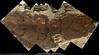
The geological contact zone at Missoula in this cropped MAHLI mosaic.

It appears that the lower unit (mudstone?) is not as resistant to erosion, when compared with the upper unit (coarse sandstone) at this location
centsworth_II
QUOTE (PaulH51 @ Jul 2 2015, 02:44 AM) *
The geological contact zone at Missoula in this cropped MAHLI mosaic...
There seems to be a duplication of features in the area circled.
Click to view attachment
PaulH51
QUOTE (centsworth_II @ Jul 2 2015, 03:20 PM) *
There seems to be a duplication of features in the area circled.

Thanks, I missed that... smile.gif I used MS ICE, will try again and see if I can get it to stitch correctly.
EDIT
I was saved by the focused merged images that have since been down-linked, I hope these have been better stitched. Clicking the image will open the 1024x573 version.

If I am interpreting the thumbnails correctly they used 16 separate images to create each the focus merged products. It's the most I have ever noticed, normally we see 8. Thanks to Gerald for the MAHLI Rule.

Full size (3801 x 2126) LINK
MrNatural
QUOTE (PaulH51 @ Jun 30 2015, 05:29 AM) *
A small mosaic using 3 focus stacked MAHLI images of "Big Arm" using white LED lighting on sol 1028 (June 28, 2015)


The target is mentioned in this USGS Mission Update from Lauren Edgar : Sol 1030: Bumping to Missoula


I don't know about the rest of you, but I found this MAHLI set of images to be rather extraordinary. Would a geologist care to comment on this? To my untrained eye, it appears to be rounded (stream-borne?) gravels deposited in what appears to be in a loosely sorted out-wash area. Obviously these gravels have been seen earlier in the MSL trip to Mt Sharp, but this appears to be another example, or am I wrong?
algorithm
A NavCam anaglyph from sol 1030


Click to view attachment


Worth a zoom or two for the wafer thin overhanging rocks. It's like they're in competition to see who can overhang the furthest before breaking off. laugh.gif

"Just...a.....little.......further!"
acastillo
QUOTE (PaulH51 @ Jul 2 2015, 02:32 AM) *
If I am interpreting the thumbnails correctly they used 16 separate images to create each the focus merged products. It's the most I have ever noticed, normally we see 8. Thanks to Gerald for the MAHLI Rule. Full size (3801 x 2126) LINK


Beautiful contact! It does not look like an unconformity. It is not obvious to me that any erosion took place between the deposition of the different rock units. However, since the lower unit has substantial veining, and the upper unit does not, there would appear to be a significant change in deposition environment and probably a significant age difference.

I love speculating geology from a 100 million kilometers away.
PaulH51
USGS Curiosity Mission Update, Sol 1033-1036 Independence Day Planning, from Ryan Anderson LINK
jvandriel
The Navcam L panoramic view stitched together from images taken on Sol 1030 and Sol 1032.

Jan van Driel

Click to view attachment
PaulH51
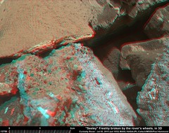
Rough and Ready anaglyph of "Steeley", a rock damaged by the rovers wheels, Sol 1032.

Full size: LINK
serpens
QUOTE (PaulH51 @ Jul 2 2015, 06:44 AM) *
...It appears that the lower unit (mudstone?) is not as resistant to erosion, when compared with the upper unit (coarse sandstone) at this location


That seems possible. If the veins are an indication of hydrofracturing then their termination could be due to a change in the lithology (mechanical properties) of the overlying layer. If so then there may have been no great time between the deposition of the two layers with the veining a product of a later event from a deeper reservoir.
Phil Stooke
Jan's panorama in circular format to show where we are.

Phil

Click to view attachment
PaulH51
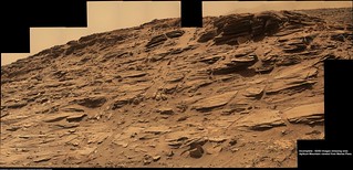
RMI of one of the heavily sculpted laminations, shown in context with its MastCam image, both acquired on sol 1032 (July 2, 2015)

Edit: typo in image text corrected
Zelenyikot
Solar eclipce and solar spots at Sol 1032. (Solar spots from SDO at June 20).
Zelenyikot
Paul's colorised photos.
Phil Stooke
We just moved back, pretty much exactly on the old tracks as far as I can see, to a place between the sol 991 and 992 locations. It will be a few days before I can do any map updates.

Phil

Phil Stooke
Looking at images from the last week, I get the impression that the dusty air is clearing, and for the first time in a long time we are getting a pretty good view of the north wall of Gale.

Phil
PaulH51
Roughly stitched 1035 left NavCam 360 (19 images)

Click image for Flickr (all sizes page) LINK opens full size

Have to agree with Phil, dust levels appear to be reducing smile.gif
jvandriel
The same Navcam NL B view on Sol 1035 but different.

Jan van Driel

Click to view attachment
Floyd
So where are we headed? I would have thought we would proceed southwest over Apikuni Mountain and join up with Logan Pass. When we were at 991, it did not look like we could cross over to Empire, so we went around. Will we go back to 967 and follow the ridge behind Mt. Shields to rejoin the outlet of Logan Pass? Here is Phil's most recent wide scale map LINK
centsworth_II
QUOTE (Floyd @ Jul 6 2015, 09:53 AM) *
So where are we headed? .... Join up with Logan Pass....

Is Logan Pass still an objective? Is the contact now being investigated the same as the one that they were headed to at Logan Pass to study? Maybe they will just head southwest by the most direct route to Murray Buttes.
PaulH51
A nice end-of-drive MAHLI (raw colours) from sol 1035
PaulH51
QUOTE (Floyd @ Jul 6 2015, 09:53 PM) *
So where are we headed?

Looks like they are headed nowhere for a couple of sols (at least) according to the latest USGS Mission Update from Lauren Edgar LINK

After that I would guess that after they have finished the additional DAN measurements and investigated the outcrop etc, then they will continue south-west down Marias Pass (bypassing Logan Pass completely, and then heading in the general direction of Murray Buttes cherry picking the any new layers along the way smile.gif

algorithm
MastCam pan from Sol1035 showing some treachorous looking dunes/drifts in the distance.


Click to view attachment
elakdawalla
I had a chat with Ashwin yesterday that I won't be able to write up until later this week, so a few tidbits: They're headed back to the sol 991 position to follow up on some stuff that piqued their interest in DAN and ChemCam observations. What comes after that depends on whether or not they are allowed to use the drill again yet.
nogal
QUOTE (algorithm @ Jul 7 2015, 04:06 PM) *
MastCam pan from Sol1035 showing some treachorous looking dunes/drifts in the distance.

Click to view attachment


Nice pan! And here is a Google Mars view of the same Logan's Run area to help locate the tracks made on sols 964 through 991, which are still visible on your pan. I'll be posting a route update later today.

Fernando

Click to view attachment
PaulH51
A few R-NavCam images looking NNW after the planned drive on sol 1037
jvandriel
The Navcam L panoramic view on Sol 1037.

Jan van Driel

Click to view attachment
PaulH51
Before & After ChemCam Laser strikes (sol 1037) R-MastCam and 2 RMI's
jvandriel
The Navcam L view on Sol 1039.

Jan van Driel

Click to view attachment
PaulH51
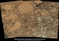
Sol 1039, before the short 'pull back' drive... R-MastCam mosaic of damaged bedrock and some of the ChemCam activity.

Original (3542 x 2504) LINK
dvandorn
Looks like Curiosity blew through a brick wall! Replete with pieces of similar-sized, rectangular-prism-shaped rocks that are red on the outside and the color of concrete on the inside. Plus little pieces of white mortar lying around!

I think our little rover don't know her own strength!

biggrin.gif

Seriously, it is interesting to see so many rock pieces that have such nice, clean, square corners and right angles. It really does give the look of a demolished brick wall.

-the other Doug
PaulH51
The base of Mt Shields, near the entrance to Marias Pass. 18 R-MastCam in a roughly stitched mosaic. Complex geology, or just tumbled blocks? Hard to be sure either way smile.gif

Original (9977 x 2472) LINK
PaulH51
Just missing one frame. Mt Shields, 62 R-MastCam frames from sol 1033 edited... Corrected name....

Original size 13178 x 6359 pixels LINK
algorithm
An attemp at a synthetic anaglyph from a Mahli image of our broken (but still courageous) friend here, on Sol 1041 .

What a difference some fine dust (sand?) can make smile.gif


Click to view attachment
PaulH51
QUOTE (algorithm @ Jul 13 2015, 03:08 AM) *
synthetic anaglyph from a Mahli image of our broken (but still courageous) friend here, on Sol 1041 .

Nice anaglyph smile.gif

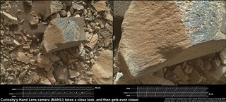
Here is a the same target with some scales based on the focus motor count (scale rule thanks to Gerald

Original (3180 x 1436 pixels) LINK
PaulH51
Another drive completed on sol 1042, just a few post drive full frames so far smile.gif

Full size LINK
jvandriel
The Navcam L view on Sol 1042.

Jan van Driel

Click to view attachment
Phil Stooke
Very nice, Jan - this is a circular version. The pattern of tracks shows up very clearly.

Phil

Click to view attachment
This is a "lo-fi" version of our main content. To view the full version with more information, formatting and images, please click here.
Invision Power Board © 2001-2024 Invision Power Services, Inc.