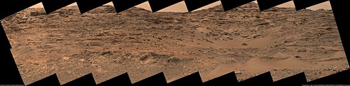
The path on the panorama (thanks for finding this Actionman) helps illustrate what seems a common situation. To avoid the deeper sand one would go on the edge of the valley up against the sloping walls (sol 984).
Also as alluded some precise driving looks to be needed to make it over Logan Pass.

Looks like the rover drove out of Logan Pass on sol 987, went north back through Jocko Chute and came to a stop close to its location on sol 976.
The Navcam NL B view on Sol 986.
Look at the wheeltracks on the right side of the panorama.
Jan van Driel
Click to view attachment
Look at the wheeltracks on the right side of the panorama.
Jan van Driel
Click to view attachment
Sol 987 - thanks, Jan - and here is a semicircular view of it which I used to find the location.
Phil
Click to view attachment
Phil
Click to view attachment
Quick animation of Phobos, sol 987 (raw files)
Click to view attachment
Link to animation on Flickr LINK
Can the mods please move this post to the correct thread? TIA
Click to view attachment
Link to animation on Flickr LINK
Can the mods please move this post to the correct thread? TIA
USGS Mission Update - Sol 987-989: Back at Jocko Butte, by Ryan Anderson
http://astrogeology.usgs.gov/news/astrogeo...-at-jocko-butte
http://astrogeology.usgs.gov/news/astrogeo...-at-jocko-butte
QUOTE
"After sol 989, we will be driving again, though where exactly we will go is still being discussed. We want to get to the stratigraphic contact at the base of Mt. Stimson, but it is proving to be difficult to reach so we are also considering alternatives"
looks as if the rock got a little tatoo (aluminum scraped off?) from one of the grousers on sol989
Click to view attachment
Click to view attachment
Right Mastcam (M-100) Sol 984.
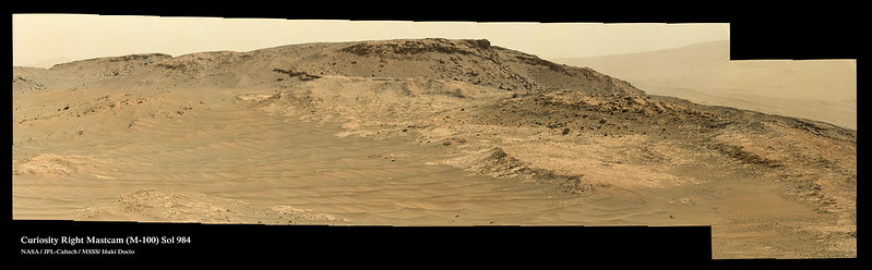
Click image for full resolution. Click for more sizes
My Curiosity Pinterest Board . Flickr Gallery
Click image for full resolution. Click for more sizes
My Curiosity Pinterest Board . Flickr Gallery
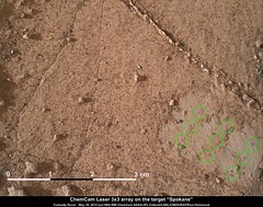
pew pew pew on sol 989 at the target called Spokane
I did the same panorama as Dig today, but they beat me to posting it so I'll skip to the stratigraphy work I did with that pan.
I had a difficult time figuring out what feature Curiosity was imaging, but I settled on Mt. Siyeh and labeled it as such, so it might be misidentified in the title
Anyway, an unannotated version of the region of interest:
Full size here
And with the geological units/features of interest highlighted:

Full size here
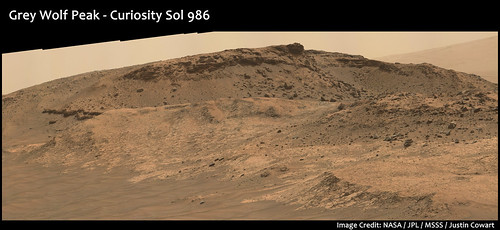
I've labeled the foreground ridge as Murray formation, since the rubble laying on top of it doesn't appear to have the distinctive cross-bedded boulders that we see in the Washboard formation. If that's the case, then the unconformity surface has a topographic relief of at least a few meters. We don't have a clear view to the base of Grey Wolf Peak, so it's hard to tell what's going on there, but there is a small cross-bedded ledge on the left side, at about the same stratigraphic level as Lolo is to Mt. Shields.
The interval between Lolo and Mt. Shields is covered by sand and small debris, so if the cliff here on the side of Grey Wolf Peak is exposing the same interval it would fill in a gap in the strat column there. It's kind of distant, but it looks to me like the rock is pretty finely layered above the lower cross-bedded ledge, with a sudden transition to a popcorn texture right below the base of the upper cross-bedded ledge. Given that transition occurs at a slightly different level across the outcrop, I'm guessing it might represent a short erosional interval before the upper cross-bedded unit was deposited. It's also interesting that the upper cross-bedded unit appears to pinch out on both sides of Grey Wolf Peak. This might represent a true depositional boundary, since if it were continuous the resistant nature of this bed should form a caprock layer around the top of the hill.
In places this middle unit of the Washboard Fm. looks like the Murray formation, but it doesn't appear to have those distinctive veiny pods. For a moment I started thinking the contact at Mt. Stimson might actually be exposing this middle Washboard layer, but a quick check turned up the veins there, so I feel confident that the contact at Mt. Stimson really is a contact between Murray and Washboard. (If it wasn't my brain was going to break trying to figure out stratigraphic relationships, so that's good.)
Finally, the upper cross-bedded unit appears to sag at left. Not entirely sure what's going on there. It could either be a small erosional scour that was filled in by the upper cross-bedded unit (as evidenced by the lack of "popcorn" there), or maybe some differential compaction.
I'm trying to figure out how to explain the erosional pattern we see now, and I might have an explanation but I can't really explain it in words so I'll have to draw a diagram. Astrogeology is hard. Any thoughts/criticisms?
Edit: updated post.
I had a difficult time figuring out what feature Curiosity was imaging, but I settled on Mt. Siyeh and labeled it as such, so it might be misidentified in the title
Anyway, an unannotated version of the region of interest:
Full size here
And with the geological units/features of interest highlighted:
Full size here
I've labeled the foreground ridge as Murray formation, since the rubble laying on top of it doesn't appear to have the distinctive cross-bedded boulders that we see in the Washboard formation. If that's the case, then the unconformity surface has a topographic relief of at least a few meters. We don't have a clear view to the base of Grey Wolf Peak, so it's hard to tell what's going on there, but there is a small cross-bedded ledge on the left side, at about the same stratigraphic level as Lolo is to Mt. Shields.
The interval between Lolo and Mt. Shields is covered by sand and small debris, so if the cliff here on the side of Grey Wolf Peak is exposing the same interval it would fill in a gap in the strat column there. It's kind of distant, but it looks to me like the rock is pretty finely layered above the lower cross-bedded ledge, with a sudden transition to a popcorn texture right below the base of the upper cross-bedded ledge. Given that transition occurs at a slightly different level across the outcrop, I'm guessing it might represent a short erosional interval before the upper cross-bedded unit was deposited. It's also interesting that the upper cross-bedded unit appears to pinch out on both sides of Grey Wolf Peak. This might represent a true depositional boundary, since if it were continuous the resistant nature of this bed should form a caprock layer around the top of the hill.
In places this middle unit of the Washboard Fm. looks like the Murray formation, but it doesn't appear to have those distinctive veiny pods. For a moment I started thinking the contact at Mt. Stimson might actually be exposing this middle Washboard layer, but a quick check turned up the veins there, so I feel confident that the contact at Mt. Stimson really is a contact between Murray and Washboard. (If it wasn't my brain was going to break trying to figure out stratigraphic relationships, so that's good.)
Finally, the upper cross-bedded unit appears to sag at left. Not entirely sure what's going on there. It could either be a small erosional scour that was filled in by the upper cross-bedded unit (as evidenced by the lack of "popcorn" there), or maybe some differential compaction.
I'm trying to figure out how to explain the erosional pattern we see now, and I might have an explanation but I can't really explain it in words so I'll have to draw a diagram. Astrogeology is hard. Any thoughts/criticisms?
Edit: updated post.
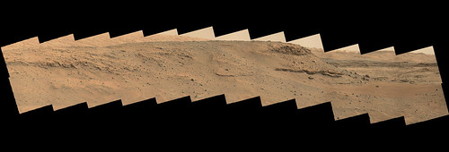
It's tricky to find these places sometimes! Actually that mountain is Gray Wolf Peak. Mt. Siyeh is on the right side, the mound on top of the Murray Formation. The tracks visible at the extreme left in the full pan are from sol 957.
Phil
Phil
QUOTE (Phil Stooke @ May 20 2015, 03:17 AM) 
It's tricky to find these places sometimes! Actually that mountain is Gray Wolf Peak. Mt. Siyeh is on the right side, the mound on top of the Murray Formation. The tracks visible at the extreme left in the full pan are from sol 957.
Phil
Phil
Thanks for the tip! I've updated my post to reflect that.
That's a lot further east than I thought it was, so I'm questioning whether marking that ledge as equivalent to Lolo is accurate. 250 m is a long way when dealing with valley fill. I still feel comfortable that the entire thing is Washboard, since it's along the Mt. Stimson - Mt. Siyeh axis, and a really close examination still didn't turn up the vein pods that are scattered throughout the Murray. Probably need to take a closer look at the Sol 957 panorama to double-check.
All I can say is "OverLoad" on all the flood of new images! Fun and Hooray...it was getting boring for a while. Really interesting features and structures appearing everywhere.
USGS Mission Update - Sol 991: Taking the high road, by Lauren Edgar
LINK
LINK
QUOTE
...The goal of todays plan is to climb uphill towards an interesting geologic contact. Its the same contact that we would have seen in Logan Pass, but the path through Marias Pass looks a little bit shorter...
This is a circular projection of Jan's panorama - the rocky ledge to the west (left) is the one above the contact science site at Logan's Run. Mt. Shields is the hill bove it.
Phil
Click to view attachment
Phil
Click to view attachment
This is a reprojection of the hazcams from sol 991 which I used to locate the rover.
Phil
Click to view attachment
Phil
Click to view attachment
anaglyph of that pleasant vista on sol990, plus a crosseye and parallel of (low-speed) rock 'turtle' from sol991
Click to view attachment Click to view attachment Click to view attachment
Click to view attachment Click to view attachment Click to view attachment
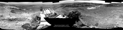
Nice climb by the rover, and a magnificent view into the Pass and its accessible geology.
USGS Mission Update - Sol 992: Marias Pass, from Lauren Edgar
USGS Mission Update - Sol 992: Marias Pass, from Lauren Edgar
QUOTE
In today’s plan, Curiosity will acquire ChemCam and Mastcam observations on the targets “Elk” and “Bull” to characterize the bright bedrock and a nearby boulder. We’ll also take several Mastcam mosaics to document the local stratigraphy. After a short drive we’ll acquire additional Mastcam images to capture the contact between the Stimson and Pahrump units...
Hmm...didn't realize the contact was up this high. I'm now wondering if Logan's Run and Lolo are small interbeds within the Murray formation similar to Whale Rock and Salsberry Peak back in Pahrump Hills. If so, I think that puts most of Grey Wolf Peak in the Murray formation.
I had been entertaining the idea that Washboard outcrop pattern was related to it being a valley-fill deposit, but it looks like the unconformity surface between Murray and Washboard is a lot flatter than I thought. It's really like having one of those frustrating field days when you're out mapping, and you find an outcrop that screws up your working hypothesis!
I had been entertaining the idea that Washboard outcrop pattern was related to it being a valley-fill deposit, but it looks like the unconformity surface between Murray and Washboard is a lot flatter than I thought. It's really like having one of those frustrating field days when you're out mapping, and you find an outcrop that screws up your working hypothesis!
QUOTE (jccwrt @ May 21 2015, 11:34 PM)
Hmm...didn't realize the contact was up this high....
As I read it, they will be imaging the contact with the Mastcam, but that does not mean that it is nearby or at the same level as the rover. Curiosity could just have a good view down and across the pass to the contact.
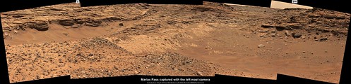
Marias Pass, left mast camera from sol 991
USGS Mission Update - Sols 993-996: A long weekend at Marias Pass from Lauren Edgar.
USGS Mission Update - Sols 993-996: A long weekend at Marias Pass from Lauren Edgar.
QUOTE
The 4 sol plan includes some large Mastcam mosaics to characterize the terrain and the contact between the Stimson and Pahrump units. The plan also includes ChemCam and Mastcam observations on the targets Hoodoo, Pinehaven, Red Sleep, and Red Horn to assess the composition of the bright outcrop and veins. On Sol 995, Curiosity will bump closer to the outcrop, to prepare for possible contact science next week...
Early analysis of the ChemCam target "Yellowjacket" points to the sediments that formed the rock having being transported by wind 
LINK to the report (PIA19661: Auto-Focused on Details in "Yellowjacket" on Mars)
QUOTE
Yellowjacket, located near an area called "Logan Pass" on lower Mount Sharp, is a layered sedimentary rock. The laser analysis yielded a composition very close to that of Mars soil and unlike the lakebed sedimentary compositions observed at lower elevations earlier in the mission. The soil-like composition may indicate that the rock formed from sediment transported by wind, rather than by water.
LINK to the report (PIA19661: Auto-Focused on Details in "Yellowjacket" on Mars)
Sol 992 left mastcam:
Click to view attachment
Click to view attachment
QUOTE (PaulH51 @ May 23 2015, 03:54 AM)
Early analysis of the ChemCam target "Yellowjacket" points to the sediments that formed the rock having being transported by wind
Would this mean there's a more general elevation threshold where sedimentary layers below are from water and above that from wind?
There is on Mount Sharp where the upper part of the mountain seems to be made up of aeolian deposits. But if Mr Steno was correct then the lower, water influenced levels would have overlain Opportunity's current position. The question is whether "Yellowjacket" was the result of cycles of inundation/dessication, a product of a late deposition following erosion of the bulk of the deposits in this area or even float from some distance away.
QUOTE (serpens @ May 23 2015, 07:01 PM)
There is on Mount Sharp where the upper part of the mountain seems to be made up of aeolian deposits. But if Mr Steno was correct then the lower, water influenced levels would have overlain Opportunity's current position. The question is whether "Yellowjacket" was the result of cycles of inundation/dessication, a product of a late deposition following erosion of the bulk of the deposits in this area or even float from some distance away.
I think cyclicity is a good possibility (within a gradual transition from lake to eolian deposits). There appears to be repeating units in the lower slopes of Mount Sharp, and Becquerel Crater shows strong evidence of climatically driven cyclicity in strata in early Mars history.
I've been thinking about the hypothetical stratigraphic expression of a Martian lacustrine cycle, so I worked out the possible stages (facies). The following (numbered) facies should be read from bottom to top:
9. (or 1.) Disconformity? - Erosion of underlying beds? It's possible the contact is conformable.
8. Eolian deposits - Wind-deposited sand and dust; larger-scale cross-bedding.
7. Exposed 'laminates' - Straight or rippled; evaporitic minerals; dessication cracks.
6. Shallow-water 'laminates' - Rippled and/or cross-bedded laminae; some evaporitic minerals?
5. Deeper-water 'laminates' - Even laminae (below influence of waves and currents).
4. Shallow-water 'laminates' - Silt to clay-sized particles; rippled and/or small-scale cross-bedded laminae; evaporitic minerals not likely.
3. Fluvial sandstone - Sand deposited as larger clasts left upstream; possible cross-bedding from fluvial processes.
2. Basal conglomerate - Larger clasts are first to be deposited.
1. Disconformity? - Erosion of underlying beds? It's possible the contact is conformable.
Some further thoughts:
- Generally speaking, eolian deposits should become more and more dominent in successively younger cycles, given that enough time is represented in the strata. I believe this is the current consensus of the Gale Crater strata.
- Not all the above facies listed may be present in the stratigraphic section at a given site.
- Some facies would be thicker than others -- sometimes greatly so.
- The beds along the edge of the lake should be dominated with sand and conglomerate, while the center of the lake may be mostly if not all laminates
- The facies types may be interbedded when transitioning from one to the next.
- Eolian deposits will not be present in places if the lake did not evaporate completely between cycles. In that case, the transition to the next cycle would be conformable.
- Interestingly, any variations between cycles would imply some processes influencing deposition beyond mere Milankovitch effects.
While a classification of "very close to that of Mars soil" is a wee bit rubbery it does seem to imply a lack of meaningful diagenesis post deposition. That would tend to reduce the probability of an overlying lacustrine environment and groundwater. A late depositional event following bulk erosion would seem more likely although "late" is itself hard to define in Martian time-scales.
My take on panorama taken with NavCam Right on sol 992:
Left Mastcam (M-34 Sol 992.
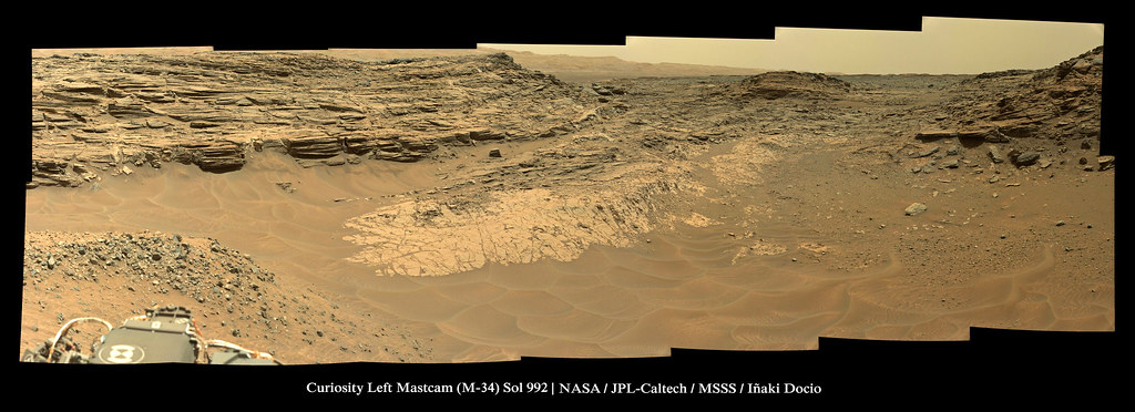
Click image for full resolution. Click for more sizes
My Curiosity Pinterest Board . Flickr Gallery
Click image for full resolution. Click for more sizes
My Curiosity Pinterest Board . Flickr Gallery
Great images, and what a nice site this is. Here are circular views from the last two stops, from the Navcam pans posted above. As ever I am always grateful to people who put these panoramas together.
Phil
Click to view attachment
Phil
Click to view attachment
Quick and dirty partial Sol 995, left NavCam, using just 11 frames, maybe enough to give Phil a fix? Until one of the others works their magic with more images
Thanks, Paul! But I got my fix on Route 66... with a quick hazcam reprojection.
Phil
Click to view attachment
We are at the red dot here (proper map update later):
Click to view attachment
Phil
Click to view attachment
We are at the red dot here (proper map update later):
Click to view attachment
QUOTE (Phil Stooke @ May 26 2015, 01:52 AM)
Thanks, Paul! But I got my fix on Route 66... with a quick hazcam reprojection.
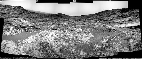
Glad they found their way around that sand
Maybe we will see a little contact science in a couple of days
I think the final route on GE will not deviate much from the following. Because it looks like Curiosity will be here for some sols and I'll be unable to update the route map for the next week or so, I'm posting here this view of the unconfirmed the route, to add to the general picture.
Fernando
Click to view attachment
Fernando
Click to view attachment
What a place to have arrived just before conjunction. Curiosity will be on a 3-week summer vacation beginning June 3. It'll be tough to wait for new science!
QUOTE (elakdawalla @ May 25 2015, 02:03 PM)
What a place to have arrived just before conjunction. Curiosity will be on a 3-week summer vacation beginning June 3. It'll be tough to wait for new science!
That gives me time to catch up with everything!
I went back and looked at the panorama that Curiosity made of the Mt. Shields area on Sol 964, it went a long way towards giving me a better picture of what's going on at the Murray/Washboard contact there.
Original pan:
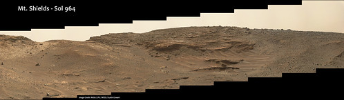
Full image here
Geology annotated:
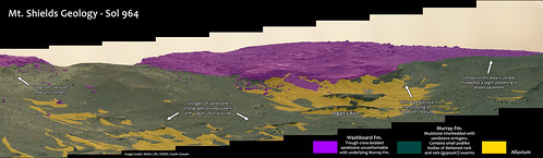
Full image here
For reference, I believe Curiosity climbed up Mt. Shields along the saddle of Murray formation on the left hand of the image, and is currently parked just behind the crest of the hill at the moment.
The problem now goes back to Grey Wolf Peak. That "popcorn" texture seems to be characteristic of the erosional surface between the Murray and Washboard, so the fact that we see it just below the top cliff on Grey Wolf Peak suggests that most of the mountain is Murray. So I went back and assembled a Sol 959 MastCam mosaic of Grey Wolf Peak to look at it from a slightly closer angle (although not as flattering as that Sol 986 mosaic) to figure out where to draw the contact. I'm completely stumped.
Here's my working image:
Full size here
I can sort of follow the contact from the base of the caprock to the left, but it's kind of murky. However, that contact would put that ledge at right in the Murray, but it visually reads as Washboard to me (poor, extremely thin and numerous layers; slightly bluish color). If it is Washboard, I'm utterly lost as to how to draw the contact from there to the summit of Grey Wolf Peak. If only the contact was as easy to follow around Grey Wolf as it is in the background on the right side! Thoughts?
This is a "lo-fi" version of our main content. To view the full version with more information, formatting and images, please click here.