A preview of the Sol 1100 L-Mastcam panorama, just fits inside the 1MB limit. Provided in raw and processed. I'll also included some links to test theories on what will work and what wont from a non registered user in Chrome and other browsers...
Click to view attachment
Link Imgur Image (4065 x 2409 pixels)
Link Imgur Comment Page.
Link Flickr Comment Page.
Link Flickr 1024 (all sizes page)
Link Flickr Original (all sizes page)
Link Flickr 1024 (direct link)
Link Flickr Original (direct link)
Note: IMGUR reduces the resolution of larger images during upload, so would not be suitable for all posts, especially the larger panoramas
So tantalizingly close yet still so far away. I know we're technically at the mountain right now, but it still doesn't feel that way. That dark dune field is always in the foreground.
Not really too keen on stitching together the entire Sol 1100 panorama, so I just focused on the portion with Mt. Sharp in it.
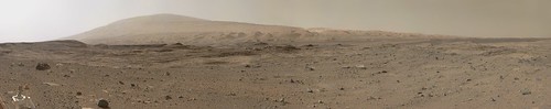
Curiosity MastCam - Sol 1100 by Justin Cowart, on Flickr
(Dropbox link in case you're having trouble with Flickr.)
Compression artifacting seems a bit worse than usual. Image qualify wasn't great in some of the brighter areas at full size, so I went ahead and shrunk the image by half.
Curiosity MastCam - Sol 1100 by Justin Cowart, on Flickr
(Dropbox link in case you're having trouble with Flickr.)
Compression artifacting seems a bit worse than usual. Image qualify wasn't great in some of the brighter areas at full size, so I went ahead and shrunk the image by half.
No Flickr problem today. Thanks for an amazing image!
SFJCody - I know what you mean about the foot of the mountain. From orbital images I guess I always thought of the dune field as the lowest point, so we shouldn't be there yet, but the reality is different. The dunes are found part way up the slope, and we are indeed already climbing. The thing that really proves it for me is the view of the northern wall of Gale crater. Now we get a pretty good view of the plains at the foot of the crater wall, which were often hidden by local topography before.
Phil
The complete Mastcam L panoramic view on Sol 1100.
A lot of artifacts due to resizing from 128MB to 600 kB.
Jan van Driel
Click to view attachment
A lot of artifacts due to resizing from 128MB to 600 kB.
Jan van Driel
Click to view attachment
QUOTE (Phil Stooke @ Sep 12 2015, 11:52 PM) 
No Flickr problem today......
No problems here today in opening Flickr images without signing in.
I expect there was a backlash forcing folk to register to view images...
Let's hope Flickr remains sign-in free...

Sol 1100
Phil, with one of your next location updates for Curiosity, would you mind including a context view that shows where we are with respect to the dune field and the projected path upward? I've been particularly curious about the delta-looking landform that we should be approaching. Has that ledge been visible yet?
Rock on a pedestal on sol 1101 (x-eyed):
Click to view attachment
Click to view attachment
QUOTE (MarsInMyLifetime @ Sep 14 2015, 06:12 AM)
Phil, with one of your next location updates for Curiosity, would you mind including a context view that shows where we are with respect to the dune field and the projected path upward? I've been particularly curious about the delta-looking landform that we should be approaching. Has that ledge been visible yet?
I plan to do a wide context map for my next Curiosity update late this week. Curiosity is about to drive out of the DEM we've been using for mapping for a long time -- it's a good moment to take stock of where we are and where we're going.
Thanks, Emily.
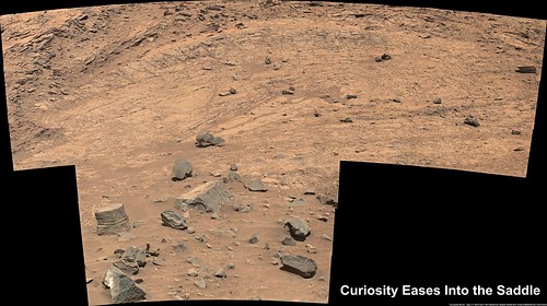
Here's a quick Hazcam reprojection to show the drive just accomplished - bringing us onto the Saddle outcrop.
Phil
Click to view attachment
Here's a quick Hazcam reprojection to show the drive just accomplished - bringing us onto the Saddle outcrop.
Phil
Click to view attachment
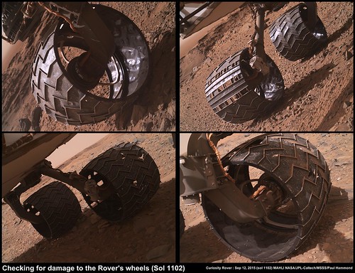
Man, I hope those wheels hold-in there...too bad cant re-tread 'em.
That Pedestal rock is really interesting, nice 3-D view of it - Thx.
That Pedestal rock is really interesting, nice 3-D view of it - Thx.
What a view from the Blackleaf Creek plateau area. I wonder if there was any sort of ledge navigating to get into the Sol 1104 position?
Went a bit nuts on the Sol 1100 mosaic - just the Mt Sharp part.
Marsinmylifetime asked for a context map. This is adapted from an image for a future project, showing where we are and three iterations of the path forward.
Click to view attachment
The alluvial fan or whatever it is does show up in images, especially our recent views of the hills ahead. I will post an extract of one next.
Phil
Click to view attachment
The alluvial fan or whatever it is does show up in images, especially our recent views of the hills ahead. I will post an extract of one next.
Phil
Here are two views that locate the edge-on view of the fan in recent images.
Phil
Click to view attachment
Click to view attachment
Phil
Click to view attachment
Click to view attachment
Travel animation from NAVCAM for Sol 1104 is 32 frames.
Here's a small preview of the right NAVCAM's view: Click to view attachment
And here's the full-size (512x256) stereo pair animation for Parallel and Cross-Eye viewing.
Disclaimer: One of the left NAVCAM frames contained no data, so I very roughly created a replacement for it by skewing and compositing the right NAVCAM frame and the adjacent left NAVCAM frame. That should give your brain enough, in motion, to mostly correct for any error automatically.
Thanks, Phil - that explains what I was just seeing. Here's a long-baseline stereo M100 view that shows that edge-on fan. Anaglyph:
Click to view attachment
And cross-eyed:
Click to view attachment
I used jccwrt's deBayered mosaic from 1099 and deBayered the new 1104 view myself. The lighting is quite different between the frames so this isn't an easy one to view.
Click to view attachment
And cross-eyed:
Click to view attachment
I used jccwrt's deBayered mosaic from 1099 and deBayered the new 1104 view myself. The lighting is quite different between the frames so this isn't an easy one to view.
Lmastcam view on sol 1104:
Click to view attachment
Click to view attachment
A big anaglyph 20000x2850 px sol 1100
im (very very roughly) guessing that the fan correlates something like this in a drive direction map, but without distant targets on the map im off by who knows how far. Also the stereo from sol1099/1100 is low-res but easy viewing.
Click to view attachment
Click to view attachment
These really caught my eye today...Interesting "leaf-like" features...these almost appear to have formed up and after much erosion took place, brine and evaporation leaving behind minerals perhaps? Any ideas?
http://mars.jpl.nasa.gov/msl/multimedia/ra...DXXX&s=1104
http://mars.jpl.nasa.gov/msl/multimedia/ra...DXXX&s=1104
QUOTE (Arizona Dave @ Sep 15 2015, 05:43 PM)
These really caught my eye today...Interesting "leaf-like" features...these almost appear to have formed up and after much erosion took place, brine and evaporation leaving behind minerals perhaps? Any ideas?
I don't have any ideas, but it looks like we're getting a better look at these (or at least similar) features in the latest images down for Sol 1105.
Click to view attachment
(color contrast greatly exaggerated)
Original
QUOTE (Phil Stooke @ Sep 15 2015, 11:11 AM)
Marsinmylifetime asked for a context map. This is adapted from an image for a future project, showing where we are and three iterations of the path forward.
The alluvial fan or whatever it is does show up in images, especially our recent views of the hills ahead. I will post an extract of one next.
The alluvial fan or whatever it is does show up in images, especially our recent views of the hills ahead. I will post an extract of one next.
Most excellent, Phil. I see that there is a lot of road ahead, and perhaps not all the water story has yet been told.
QUOTE (Herobrine @ Sep 15 2015, 05:40 PM)
I don't have any ideas, but it looks like we're getting a better look at these (or at least similar) features in the latest images down for Sol 1105.
Click to view attachment
(color contrast greatly exaggerated)
Click to view attachment
(color contrast greatly exaggerated)
The cimage you did really shows the sand and material under it to appear to be different in color/composition and granular size...and the "under" part goes back further than I first thought as well. Nice contrast and color stretch - thx!
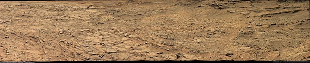
Curiosity Mission Update from Lauren Edgar - Sol 1106: Searching for the Next Drilling Location LINK
QUOTE
After some additional contact science on the Murray formation (of the location shown in the above Mastcam image), were now in search of a good sandstone for our next drill target.
The goal of todays plan is to drive towards a bright patch of blocky outcrop that was first identified in orbital images, and to see if this outcrop is an area that we might want to investigate further. Todays plan includes an hour of targeted science, followed by a short drive towards the bright outcrop, and post-drive imaging for targeting.
In the morning science block, well acquire ChemCam and Mastcam observations of the targets Prichard and Cat Creek to look for changes in composition through the Murray formation. We also planned a Mastcam mosaic of the Vaughn area to document the Murray-Stimson contact. Then well acquire a Mastcam mosaic of the Rice area to investigate the bright patch from our current location. After a short ~12 m drive, well acquire standard post-drive imaging, as well as another large Mastcam mosaic of the Rice area. As the Geology Theme Lead today, I had to balance downlink priorities to make sure that well get all of the necessary imaging down in time to make a decision tomorrow (is this a good place to investigate further? Or should we keep driving?). Cant wait to see what the new images will reveal!
QUOTE (Arizona Dave @ Sep 15 2015, 09:21 PM)
The cimage you did really shows the sand and material under it to appear to be different in color/composition and granular size...and the "under" part goes back further than I first thought as well. Nice contrast and color stretch - thx!
While I do think that the material under it exhibits actual variations in color, I feel I should add a disclaimer to the image I posted; I would suggest being cautious about interpreting anything on too small of a scale with the type of heavy color contrast exaggeration I did. It can bring out otherwise subtle debayering artefacts that are more likely to occur with small grains. It can have a similar effect on JPEG artefacts when color contrast in the original image is very low or in particularly dark areas. I'm always worried, when manipulating lossy-compressed 8-bit-per-sample imagery that I'm going to invent features or qualities of features in the process.

I'm coming back to image processing after some weeks busy with the preparation of classes for students.
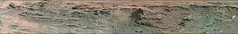
Here is my take on the MC100 postcard of the hills of Mount Sharp on sol 1099.
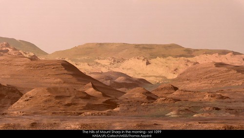
Here is my take on the MC100 postcard of the hills of Mount Sharp on sol 1099.
Mahli pan and attempted synthetic anaglyph of the brushed area sol 1106
Click to view attachment
Click to view attachment
Click to view attachment
Click to view attachment
beautiful image neo56!! so now i have my new desktop image [if annoying flickr/yahoo signup gets in way (Chrome) paste url into IE where doesn't ask to sign up, i suspected that must be browser cookie waiting for Nth download before requiring sign-in, but obliterating Chrome cookies in last hour didn't make it go away] anyway..
here are stereo views of part fo the pan showing a turtle rock at middle left and toppled turtle rock mear upper right sol1105
and a very awkward crosseye between the sol1105 sol1106 feature FWIW..
Click to view attachment Click to view attachment Click to view attachment
here are stereo views of part fo the pan showing a turtle rock at middle left and toppled turtle rock mear upper right sol1105
and a very awkward crosseye between the sol1105 sol1106 feature FWIW..
Click to view attachment Click to view attachment Click to view attachment
Very roughly stitched Sol 1106 'Partial' end-of-drive L-NavCam. Midnight Planets puts it at 8 meters WSW (point-to-point)
Original (6044 x 1300) LINK
Original (6044 x 1300) LINK
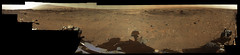
Here are the global + zoom views taken on Sol 1104 by the Curiosity rover on the valley in the background and located at the foothills of Mount Sharp several km away.
An impressive perspective indeed ! (the zoom view was processed from raw red, green and blue filtered pictures through white balancing).
Well, back to the old times of the Viking missions !
Enjoy
Click to view attachment Click to view attachment
An impressive perspective indeed ! (the zoom view was processed from raw red, green and blue filtered pictures through white balancing).
Well, back to the old times of the Viking missions !
Enjoy
Click to view attachment Click to view attachment
QUOTE (vikingmars @ Sep 17 2015, 03:13 AM)
Here are the global + zoom views taken on Sol 1104 by the Curiosity rover on the valley in the background and located at the foothills of Mount Sharp several km away.
An impressive perspective indeed ! (the zoom view was processed from raw red, green and blue filtered pictures through white balancing).
Well, back to the old times of the Viking missions !
Enjoy
An impressive perspective indeed ! (the zoom view was processed from raw red, green and blue filtered pictures through white balancing).
Well, back to the old times of the Viking missions !
Enjoy
SURREAL looking...coming from AZ, it reminds me of some of our more remote areas. Imagine the silence and serenity that could be had there, if one could...
Thank you!!
Anyone want to take a guess at how far up or around those hills we ever get?
How far up we get will depend on too many factors to consider, i give up.. I think that pointy 'sharp' foothill (heh, heh) we can see in this snippet of vikingmars' image correlates per the below, to get to that sharp hill would take a couple years in my guesstimation. this is from google earth and you can see the tiny bit of red line at bottom, according to Fernando's latest kml the actual traverse path is a bit to the left of that (not visible in this snippet)
Click to view attachment
Click to view attachment
I love it when artist's impressions turn out to be right
Click to view attachment
A simulation from very early on (pre-landing?) of the approach to the slopes of Mt Sharp compared to Thomas' recent mosaic.
Click to view attachment
A simulation from very early on (pre-landing?) of the approach to the slopes of Mt Sharp compared to Thomas' recent mosaic.
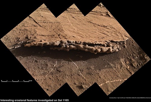
Mosaic of the Stimson-Murray contact inside "The Saddle" on sol 1105:
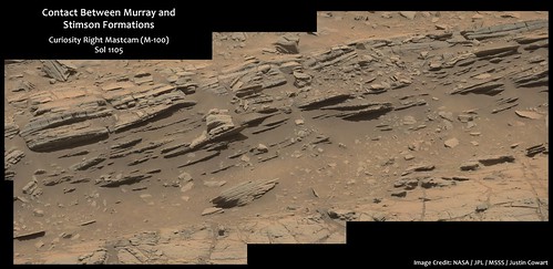
Stimson-Murray Contact by Justin Cowart, on Flickr
Imgur link
Interesting lateral change in texture along the prominent bed at the top of the image. Goes from being coarse- and fine-grained interbeds at left to generally fine-grained laminations at right.
Stimson-Murray Contact by Justin Cowart, on Flickr
Imgur link
Interesting lateral change in texture along the prominent bed at the top of the image. Goes from being coarse- and fine-grained interbeds at left to generally fine-grained laminations at right.
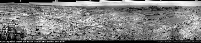
Sol 1106 Post drive left MastCam using 22 frames, roughly stitched in MS ICE
riginal (12297 x 2516) LINK
riginal (12297 x 2516) LINK
Travel animation from NAVCAM for Sol 1106 is 20 frames.
Here's a small preview of the left NAVCAM's view: Click to view attachment
And here's the full-size (512x256) stereo pair animation for Parallel and Cross-Eye viewing. File sizes are each 3 MiB.
Here's a small preview of the left NAVCAM's view: Click to view attachment
And here's the full-size (512x256) stereo pair animation for Parallel and Cross-Eye viewing. File sizes are each 3 MiB.
QUOTE (atomoid @ Sep 17 2015, 04:49 PM)
How far up we get will depend on too many factors to consider, i give up.. I think that pointy 'sharp' foothill (heh, heh) we can see in this snippet of vikingmars' image correlates per the below, to get to that sharp hill would take a couple years in my guesstimation. this is from google earth and you can see the tiny bit of red line at bottom, according to Fernando's latest kml the actual traverse path is a bit to the left of that (not visible in this snippet)
Years it may....getting up to that general area would be awesome, and hopefully into new geology. Great graphic BTW - I think its about spot-on :-)
Perhaps they will want to explore the "channel flow" as well.
This is a "lo-fi" version of our main content. To view the full version with more information, formatting and images, please click here.