QUOTE (atomoid @ Sep 9 2015, 05:10 AM)

Interpretations anyone?
I'll leave that to the experts

But it is impressive
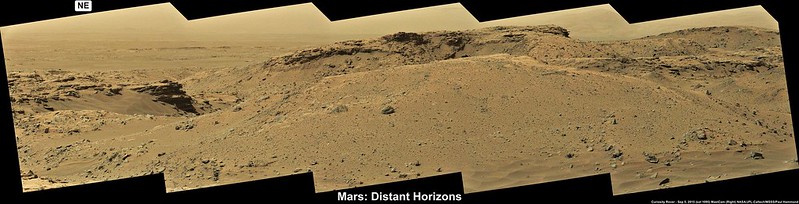
Meanwhile we dont have all the NavCam images yet, but these 5 frames (L-NavCam, sol 1098) give us an idea of the terrain in new location. Roughly assembled in MS ICE.
The drive appears to have been cut short of the planned distance. Maybe the rover spotted the outcrops to the right (inside Bridger Basin) and fancied a closer look at them
If not, there is some better driving terrain to the south and then west around the basin.
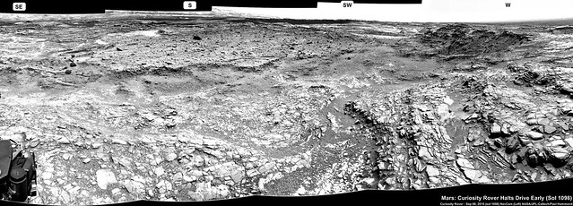
Original (3841 x 1382)
LINKEdit : Curiosity Mission Update from Ken Herkenhoff, Sol 1099: Driving again
LINKQUOTE
MSL did well over the long weekend, except that the Sol 1098 drive was halted after 13 meters of the planned 25 meters because the rover could not confirm that the path ahead was safe. So the plan for the Sol 1099 drive is essentially to complete the rest of the previously planned drive. The only significant problem I've had to grapple with today as SOWG Chair is that the last 5 relays of data through MRO have returned significantly less data than expected; if this problem continues, we will barely receive enough data to plan another drive on Sol 1100. Fortunately, the MRO team understands the problem and knows how to correct it, and there is a good chance that we will receive all the data we need in time for planning tomorrow morning. This situation reminds me of how much we depend on the Mars orbiters and the teams that operate them, and to thank them for their continued support of the MSL mission.
Before the Sol 1099 drive, we have time to acquire ChemCam and Mastcam observations of "Mission Creek" and "Chamberlain," plus MastCam mosaics of "Bridger Basin," "Hackley Point," and "Police Creek." The rover will wake up early on the morning of Sol 1100 to acquire a big stereo mosaic of the far wall of Bridger Basin, because the illumination will be better early in the morning. Mastcam will also take a 360-degree panorama with the left camera.


 ).
).