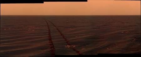
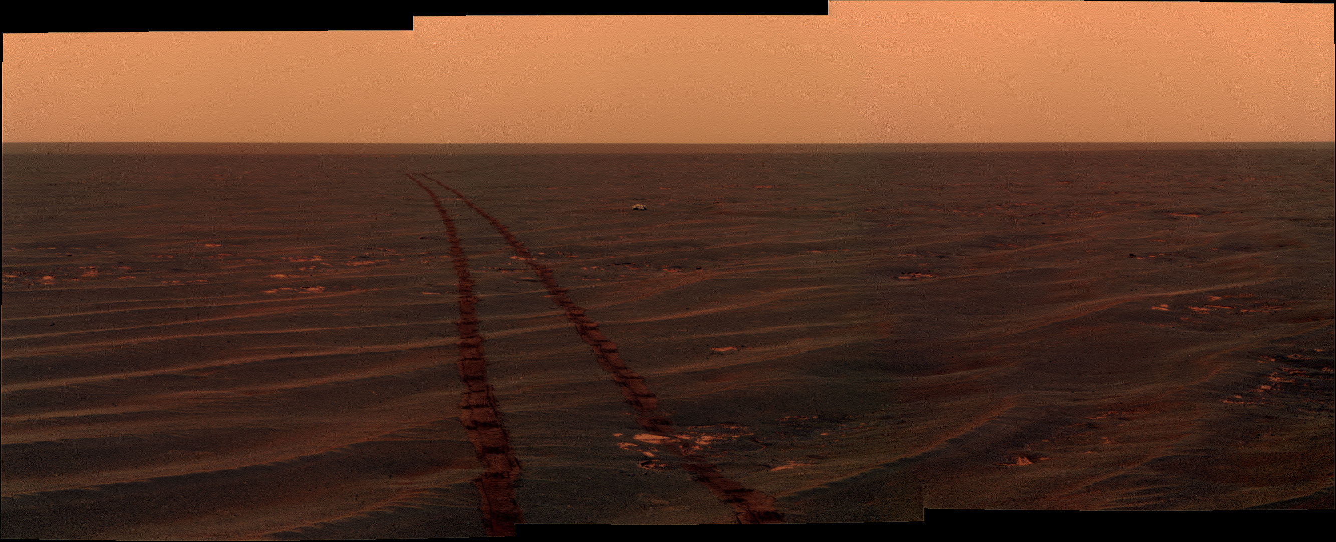
Couple of colourisations of recent views...
Click to view attachment
Click to view attachment
Full Version: Post Conjunction: Santa Maria to Cape York
Pages: 1, 2, 3, 4, 5, 6, 7, 8, 9, 10, 11, 12, 13, 14, 15, 16, 17, 18, 19, 20, 21, 22, 23, 24, 25, 26, 27, 28, 29, 30, 31, 32
I have a question about the first image (the top one) Stu just posted. The rock on the left looks like it is cracked in half, if you follow the crack to the right there almost appears to be a line in the sand and then another rock on the right that is cracked. It is pretty much a straight line (at least it appears to be) There is even a faint line on the rock inbetween the 2 cracked rocks.
My question is what could/would cause that or is it just the angle the image was taken?
My question is what could/would cause that or is it just the angle the image was taken?
It's just random cracks everywhere you look in that picture. Nothing to explain really. That's what cracked rocks look like.
Phil
Phil
Weren't we just discussing sore thumbs? 
http://qt.exploratorium.edu/mars/opportuni...2M1.JPG?sol2654
http://qt.exploratorium.edu/mars/opportuni...2M1.JPG?sol2654
QUOTE (Phil Stooke @ Jul 14 2011, 03:05 PM) 
It's just random cracks everywhere you look in that picture. Nothing to explain really. That's what cracked rocks look like.
Phil
Phil
I know that is what a cracked rock looks like...it looked to me like there was a line in the sand that lined up with the crack, almost like an indentation.
Thats an interesting question, I'd thought the cracks extend down to the base and perhaps beyond whatever the boundary of the top cracked layer is. I dont expect the cracks are completely random and line up by chance, I'm assuming they are caused presumably by dessication shrinkage withing a large segment, so a crack could extend below and across the subsequent sequence of broken sub-blocks and layers hidden below the thin litter of soil that currently lies atop.
Along those lines, the crack line Bunker9603 is curious about would extend across several broken blocks as a large segment cracked into smaller blocks and its vertical layers detached from each other, some block layers perhaps subtley shifting as soil weathers away, allowing soil to attempt to fill the linear gap across the now separate sub-blocks and sand..
Along those lines, the crack line Bunker9603 is curious about would extend across several broken blocks as a large segment cracked into smaller blocks and its vertical layers detached from each other, some block layers perhaps subtley shifting as soil weathers away, allowing soil to attempt to fill the linear gap across the now separate sub-blocks and sand..
Take a tiny topographic feature.
Take prevailing winds.
Apply a couple of billion years.
You'll get patterns, lines, features, streaks and all sorts of things that look like they're interconnected.
Take prevailing winds.
Apply a couple of billion years.
You'll get patterns, lines, features, streaks and all sorts of things that look like they're interconnected.
Take a tiny topographic topic.
Take prevailing views.
Apply a couple of UMSF posts.
You'll get opinions, lines of thought, factions and all sorts of things that look like they're interconnected.
Take prevailing views.
Apply a couple of UMSF posts.
You'll get opinions, lines of thought, factions and all sorts of things that look like they're interconnected.
True, get enough monkeys typing and they recreate the Library of Congress, but isnt the Meridiani terrain basically formed of dessicated deposits? it seems to follow that you might have a lot of intersecting cracks form with certain ones becoming dominant as dessication progresses further, subbsequent wind erosion should reveal rather than create such features, finally leaving stuff like we see today.. i see similar patterns in dried-up river silt. But of course thats my lay interpretation, hopefully one of the Geologists reading here can set it straight.
It's been a long time, but back when Opportunity left Eagle crater there were some major cracks or maybe they should be called crevices. I can't remember the geological term used to describe them, but I believe they all had a similar, or at least a preferred, orientation.
Haven't seen anything like that since however. Can anyone remember if that common orientation was confirmed? Meridiani Planum might be experiencing common stresses, although personally I don't even see the claimed long crack in the surface rocks at our present location. I am only saying that if someone did demonstrate a common orientation of cracks it would not be all that surprising. However, I am not geologist, and I only chimed in on this subject because it reminded me of those major cracks or crevices near Eagle crater. And that we never saw any more.
Haven't seen anything like that since however. Can anyone remember if that common orientation was confirmed? Meridiani Planum might be experiencing common stresses, although personally I don't even see the claimed long crack in the surface rocks at our present location. I am only saying that if someone did demonstrate a common orientation of cracks it would not be all that surprising. However, I am not geologist, and I only chimed in on this subject because it reminded me of those major cracks or crevices near Eagle crater. And that we never saw any more.
No, there's no common orientation. It's just local phenomena everywhere, vaguely polygonal or rectilinear fracture patterns caused by dessication and shrinkage or localized shifting of layers due to impact, erosional unloading or changes in ground water. My point earlier was that you can explain general phenomena but it's a waste of time trying to account for every individual crack, just like it would be a waste of time trying to account for the shape of every individual rock on a beach.
Phil
Phil
Another significant drop in the local horizon tosol - not long now folks!
http://qt.exploratorium.edu/mars/opportuni...GFP2360L2M1.JPG
Compared to this just 80m back
http://qt.exploratorium.edu/mars/opportuni...00P2359R2M1.JPG
http://qt.exploratorium.edu/mars/opportuni...GFP2360L2M1.JPG
Compared to this just 80m back
http://qt.exploratorium.edu/mars/opportuni...00P2359R2M1.JPG
Things are happening fast now
I'm now guessing that we will pass to the south of Approach Crater in a more direct line to Cape York. There's a sharp little crater down there just inside the estimated visibility line, which might be on our route. Just 3 more driving sols to visibility of Cape York, by the standards of recent "long" drives", and perhaps 5-6 drives if they are of the shorter drive variety. Not forgetting that the MER mast height may give us earlier visibility than the line suggests...
Another great view
http://qt.exploratorium.edu/mars/opportuni...GFP2360L2M1.JPG
There is a tiny bump to the right of the "approach crater"
http://qt.exploratorium.edu/mars/opportuni...GFP2360L2M1.JPG
There is a tiny bump to the right of the "approach crater"
I do think however that Opportunity will make one more small dip downward based on how they are positioning her.
QUOTE (Sunspot @ Jul 15 2011, 01:40 PM)
There is a tiny bump to the right of the "approach crater"
Almost certainly a little ripple beside AC. One of the "sore thumbs" we talked about.About the route to come, it does look as though we're heading straight towards Spirit Point, but on the other hand we're now sitting very close to "Stu's Notch" (sorry, Stu!), so I could still see us heading to Approach Crater next. One more drive and we should know which it is.
QUOTE (Sunspot @ Jul 15 2011, 03:40 PM)
Another great view
http://qt.exploratorium.edu/mars/opportuni...GFP2360L2M1.JPG
There is a tiny bump to the right of the "approach crater"
http://qt.exploratorium.edu/mars/opportuni...GFP2360L2M1.JPG
There is a tiny bump to the right of the "approach crater"
I'd say I can see a little bit of the interior of Approach Crater now and the "unnamed crater" on the other side of Endeavour is now again fully visible.
To summarize the discussion of the past several pages in graphic form:
Full view of Cape York, per Stu:

Full view of Cape York, per Doug:

Did I get that right?
Full view of Cape York, per Stu:
Full view of Cape York, per Doug:
Did I get that right?
A picture (or a pair of pictures) is worth a thousand words!
Phil
Phil
LOL. Perfect Jonathan. Stu's going to love it.
I alway thought Mars had beautiful Green cities for its little Green men!
Anyway, as a near-daily lurker enjoying the fine banter.
But I do have to say, whether its Oz or Kansas, I just want to get there after plotting the past 3-4 years. So close! Next few weeks should be exciting.
Anyway, as a near-daily lurker enjoying the fine banter.
But I do have to say, whether its Oz or Kansas, I just want to get there after plotting the past 3-4 years. So close! Next few weeks should be exciting.
QUOTE (ilbasso @ Jul 15 2011, 09:26 PM)
To summarize the discussion of the past several pages in graphic form:
Did I get that right?
Did I get that right?
Brilliant! Easily one of the funniest things I've ever seen on here.
That's going right in my Mars Rovers Outreach talk!

QUOTE (ilbasso @ Jul 15 2011, 08:26 PM)
Full view of Cape York, per Doug:
And here's the 10x Philovision version:Click to view attachment
See? Plenty of relief there!
Ouch! My eyes hurt...
Phil
Phil
I know what you're all thinking...
"As Oppy approaches Endeavour, wouldn't it be brilliant if one of the MER team started writing a blog, something like Scott's "Mars and Me" but focussing on what's happening behind the scenes as Oppy closes in on Cape York and enters a whole new phase of her adventure... somewhere where we could ask questions..."
You'd better take a look at this then:
http://opportunityendeavour.blogspot.com
Say hello to Stu's Notch:
http://qt.exploratorium.edu/mars/opportuni...0M2.JPG?sol2656
http://qt.exploratorium.edu/mars/opportuni...0M2.JPG?sol2656
Not so much a "notch" as a "nitch" (i.e. a rather poor nick of a ditch)... 
Short movie of the last 52 sols of the crater wall crater.
I put on the reverse gear at the last part to see the crater raising again.
I put on the reverse gear at the last part to see the crater raising again.
Approach to Endeavour Crater... Sols 2553 to 2654.
I've tried to line up the far wall of Endeavour so that the image is stable and the horizon/terrain appears to undulate.
Small animated gif below and a 3.46mb animated gif version here.
Click to view attachment
Small movie below and a larger version on YouTube.
Click to view attachment
EDIT: A 'bounce' version of the approach to/drive-by of 'Approach Crater'.
Click to view attachment
Enjoy
QUOTE (MarkG @ Jul 11 2011, 07:18 PM)
I made up a little tune a while back called "Cresting the Rise", and I thought this might be a good thing to share with the UMSF Rover fans...
Something to listen to while we wait...
thanks (makes me inpatient Something to listen to while we wait...
 )
)Mike
I enjoyed it. It's much more stable than mine.
Can't wait to see the dropping of the near horizon so that we can see the bottom of this damn crater wall ...
Can't wait to see the dropping of the near horizon so that we can see the bottom of this damn crater wall ...
We are all "nervous", I guess.
Two more drives and we should be reaching "Approach Crater" and the local high point.
Two more drives and we should be reaching "Approach Crater" and the local high point.
Yep, and we are now more or less 100 Sols before Curiosity launch.
Sol 2643. I know I'm a bit late, but I was missing one L7 frame
much better late than never
Mike
Mike
"Notch" or "nitch", here it is in 3D:
Click to view attachment
PS: Thanks for the Endeavour animations, guys!
Click to view attachment
PS: Thanks for the Endeavour animations, guys!
Great Panorama, Damien... I see the (in)famous "missed meteorite"!
I made some little changes in order to have more familiar colors and smoother sky, I hope you'll like it:
I made some little changes in order to have more familiar colors and smoother sky, I hope you'll like it:
It gives the apparence of a dusty stormy sky.
But it's a good version you made.
But it's a good version you made
.
Latest drive deflects a little north from the previous trend line. If we get 2 more drives like the last one, we are on the "Approximate Line of Cape York Visibility", just short of Approach Crater.
Has exploratorium broken down again?
Working fine for me. I would expect the next batch of pictures, including 2658 "post-drive" nav/pancams, to be available at 13:35UTC.
No, hazcams were posted after the drive yestersol as well as some older navcams.
Post drive navcams or pancams were scheduled for tosol instead (to enable longer drive time) so expect those sometime today.
Post drive navcams or pancams were scheduled for tosol instead (to enable longer drive time) so expect those sometime today.
Gentlemen, prepare to begin dropping your jaws... The 2658 drive gave us a big horizon drop:
http://qt.exploratorium.edu/mars/opportuni...2M1.JPG?sol2659
Another drive and we may exceed our best previous view of the far rim...
http://qt.exploratorium.edu/mars/opportuni...2M1.JPG?sol2659
Another drive and we may exceed our best previous view of the far rim...
Just ... a few ... drives ... more ... and ...
QUOTE (fredk @ Jul 18 2011, 06:54 AM)
...The 2658 drive gave us a big horizon drop:...
http://qt.exploratorium.edu/mars/opportuni...2M1.JPG?sol2659
http://qt.exploratorium.edu/mars/opportuni...2M1.JPG?sol2659
Behold! The return of Cyclops!
I'm starting to get the impression that there maybe a rather large hole up ahead!
The new view is very similar to this one, 3 Earth days back, except that Approach Crater is of course bigger and closer. Rather suggests we have been in a dip and are rising out of it again. It can only get better...
QUOTE (Sunspot @ Jul 15 2011, 02:40 PM)
Another great view
http://qt.exploratorium.edu/mars/opportuni...GFP2360L2M1.JPG
http://qt.exploratorium.edu/mars/opportuni...GFP2360L2M1.JPG
This is a "lo-fi" version of our main content. To view the full version with more information, formatting and images, please click here.