Full Version: Post Conjunction: Santa Maria to Cape York
Pages: 1, 2, 3, 4, 5, 6, 7, 8, 9, 10, 11, 12, 13, 14, 15, 16, 17, 18, 19, 20, 21, 22, 23, 24, 25, 26, 27, 28, 29, 30, 31, 32
Wow, last two anaglyphs were excellent. Thank you!
Neo56: Wow, you are judicious in your posts--6 in 7 years. As member #79 you are one of the founders of UMSF. Once you finish your PhD, you will have no excuse for not posting more. Thanks for the anaglyph.
Heyyy, Thomas ! You didn't tell me that you was one of the first members of UMSF  . Glad to see you there. You're anaglyph is beautiful.
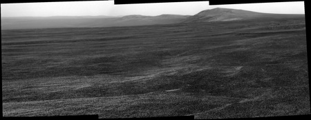
So, I'm just posting the link to my version of the panorama http://www.db-prods.net/marsroversimages/O...2668-pancam.jpg
Almost there
. Glad to see you there. You're anaglyph is beautiful.So, I'm just posting the link to my version of the panorama http://www.db-prods.net/marsroversimages/O...2668-pancam.jpg
Almost there
The dark flat feature in the new navcam image really seems oddly flat and featureless for CY, which makes me think it could alternatively be our first glimpse of the dark material that is filling the north-center bottom of Endeavour, lying higher than the margins and the south part. Compare this stretched navcam (anaglyph) and a screenshot of Google Mars, similarly stretched (3x).
Another move on 2670?
QUOTE
02670 p1154.01 0 0 0 0 0 0 front_hazcam_idd_unstow_doc
02670 p1165.00 0 0 0 0 0 0 flhaz_IDD_check_subframe_2bpp_pri_41
02670 p1211.03 0 0 0 0 0 0 ultimate_front_haz_1_bpp_pri_15
02670 p1254.02 0 0 0 0 0 0 front_haz_fault_pri15_4bpp
02670 p1311.07 0 0 0 0 0 0 rear_haz_ultimate_1_bpp_crit15
02670 p1354.01 0 0 0 0 0 0 rear_haz_fault_pri15_4bpp
02670 p1977.22 0 0 0 0 0 0 navcam_3x1_az_162_3_bpp
02670 p2111.06 0 0 0 0 0 0 pancam_drive_direction_3x1_L2R12
02670 p2111.06 0 0 0 0 0 0 pancam_cal_targ_L234567Rall
02670 p2571.27 0 0 0 0 0 0 pancam_Great_Detached_Reef_L257R2
02670 p2572.27 0 0 0 0 0 0 pancam_Madeira_Island_L257R2
02670 p2573.27 0 0 0 0 0 0 pancam_Gibraltar_L234567Rall
02670 p2601.05 0 0 0 0 0 0 pancam_tau_L78R48
02670 Total 0 0 0 0 0 0
QUOTE (MoreInput @ Jul 28 2011, 07:18 PM) 
Wan't to know how the rover planning day was for this drive? http://opportunityendeavour.blogspot.com/ from Matt Lenda.
I love the over the shoulder view of the great MER engineers. I assume I wasn't the only one, seeing him as RP-1, rooting for Paolo to complete and deliver his sequences on time. As I've learned from Scott's blog and other sources IDD work may not be as glamorous as 120m drives but can be annoyingly finicky to code.
It's amazing how not only do we humanize the rovers whose journeys we have followed all these years, but we feel that we share in the triumphs of the scientists and engineers who built and operated them. MER has done a stupendous job of outreach. Even though I have never met one of them in person, I have been privileged to share in the (continuing) adventure of exploration. Thank you MER!
QUOTE (marswiggle @ Jul 29 2011, 05:01 AM)
The dark flat feature in the new navcam image really seems oddly flat and featureless for CY, which makes me think it could alternatively be our first glimpse of the dark material that is filling the north-center bottom of Endeavour, lying higher than the margins and the south part. ...........
The anaglyph does seem to show a crater on top of a hill.. which makes me think of Spirit Point.
QUOTE (marswiggle @ Jul 29 2011, 04:01 AM)
The dark flat feature in the new navcam image really seems oddly flat and featureless for CY, which makes me think it could alternatively be our first glimpse of the dark material that is filling the north-center bottom of Endeavour, lying higher than the margins and the south part.
Yeah, maybe, however my thoughts are the other way around: it looks exactly as flat and featureless as I was expecting for CY and I wouldn't expect a distant (and hence very large) feature to be so flat and straight.
QUOTE (Nix @ Jul 29 2011, 08:15 AM)
The anaglyph does seem to show a crater on top of a hill.. which makes me think of Spirit Point.
I think we can still only see the northern half of CY. SP is still over the horizon at the moment.
QUOTE (SFJCody @ Jul 29 2011, 04:25 AM)
Another move on 2670?
From that blog, sounds like they are going back to something they drove past.
No, I think the "back up to the second MI stack" reference means they were asked to re-take some microscopic imager pictures, it's not a drive back to a previous target.
QUOTE (jamescanvin @ Jul 29 2011, 09:25 AM)
I think we can still only see the northern half of CY. SP is still over the horizon at the moment.
Ah, so you don't say "under the horizon" in English? - What a wonderful language...
I wouldn't personally have said "under the horizon" but over/below/beyond would all be equally acceptable to me. (Note English was never my strong point!)
Back on topic, Stu is right I didn't see anything to suggest they are going back. Furthermore as new drive direction pancams are planned I think tosols drive is more than a bump to reposition at this outcrop. I'm betting on a longish drive and if we make it past the little crater ahead I think most of CY could come into view. An exciting afternoon/evening ahead!
Back on topic, Stu is right I didn't see anything to suggest they are going back. Furthermore as new drive direction pancams are planned I think tosols drive is more than a bump to reposition at this outcrop. I'm betting on a longish drive
and if we make it past the little crater ahead I think most of CY could come into view. An exciting afternoon/evening ahead!
QUOTE (jamescanvin @ Jul 29 2011, 08:25 AM)
it looks exactly as flat and featureless as I was expecting for CY
Agreed. Also, remember the pancams we had of CY on 2665 - that's clearly a local feature, not far rim. The far rim is so far away (22km!) that even a jet black feature would appear light grey because of all the haze in the air right now.(BTW, "over the horizon" is used in a similar sense as "over the hill", ie "you'd have to go over the hill to get there". But of course the quirks of English could take up a whole thread, or a whole forum...)
QUOTE (Eluchil @ Jul 28 2011, 09:23 PM)
I love the over the shoulder view of the great MER engineers. I assume I wasn't the only one, seeing him as RP-1, rooting for Paolo to complete and deliver his sequences on time. As I've learned from Scott's blog and other sources IDD work may not be as glamorous as 120m drives but can be annoyingly finicky to code.
It's amazing how not only do we humanize the rovers whose journeys we have followed all these years, but we feel that we share in the triumphs of the scientists and engineers who built and operated them. MER has done a stupendous job of outreach. Even though I have never met one of them in person, I have been privileged to share in the (continuing) adventure of exploration. Thank you MER!
It's amazing how not only do we humanize the rovers whose journeys we have followed all these years, but we feel that we share in the triumphs of the scientists and engineers who built and operated them. MER has done a stupendous job of outreach. Even though I have never met one of them in person, I have been privileged to share in the (continuing) adventure of exploration. Thank you MER!
 It's a fun gig!
QUOTE (Stu @ Jul 29 2011, 04:00 AM)
No, I think the "back up to the second MI stack" reference means they were asked to re-take some microscopic imager pictures, it's not a drive back to a previous target.
This is correct. We did a set of four 1x1x5 MI stacks.
For sol 2670, I believe they planned a drive that included a "back up and take a peek at the IDD'd targets" and then a 100-meter or so drive. Though I can't quite remember. I'll check in later today. (on my *off* day!)
EDIT: They planned only about 70 meters. This was intentional -- they wanted to look at a filled-in crater.
Welcome, Matt! About time you joined us! 
And thanks again for the great blog you're now writing. It's giving us some great insights.
And thanks again for the great blog you're now writing. It's giving us some great insights.
QUOTE (Matt Lenda @ Jul 29 2011, 04:54 PM)
they wanted to look at a filled-in crater.
Thanks for the update, Matt! That'd be Stu's "Almost There" crater, with the big dune on one side.Regardless of how we define "arrival" at Endeavour, I say after the next drive it'll be official: We're almost there!
I had dinner with two icy moons scientists last night. They had no idea that Opportunity's finally at her destination. I filled them in
Welcome, Matt!
Welcome, Matt!
To clarify my line of thought re the navcam observation: yes we have indeed seen the top of CY, that's not questionable. But we have since moved considerably to the southeastern direction and the high part is now rather far to the left of the 'Cyclops' crater. Sol 2667 navcam for comparison. So we should now have an unobstructed view to Endeavour over the lower part of CY, which according to relief maps and anaglyphs should not rise too many inches above our current level on the plain, nor be visible separately of the plains.
But I am not going to waste everyone's time by pursuing this any more before the new pancams will solve the problem!
But I am not going to waste everyone's time by pursuing this any more before the new pancams will solve the problem!
Looks like ~65m from the tracking data.
QUOTE (jamescanvin @ Jul 29 2011, 08:31 PM)
Looks like ~65m from the tracking data.
This would mean we're very close to the dune, right? Can't wait to see Cape Tribulation over the dune
Just on the west side of it I think. Wrong side to see Cape Trib over it. The dune could be blocking the view of Cape York.
Waiting...
Waiting...
QUOTE (marswiggle @ Jul 29 2011, 07:04 PM)
we have since moved considerably to the southeastern direction and the high part is now rather far to the left of the 'Cyclops' crater
That's a good point. That means the wide, flat piece of CY visible on the 2668 navcam has got to be the central part of CY. It is more visible than I'd've expected too, but that's good news!
QUOTE (climber @ Jul 29 2011, 06:40 PM)
Can't wait to see Cape Tribulation over the dune
Today probably we will not see anything. I think that again is problem with exploratorium.
There are some new pics on the main web site (http://marsrover.nasa.gov/gallery/all/opportunity.html). But only 4 new Pancams (Stu viewed one above)
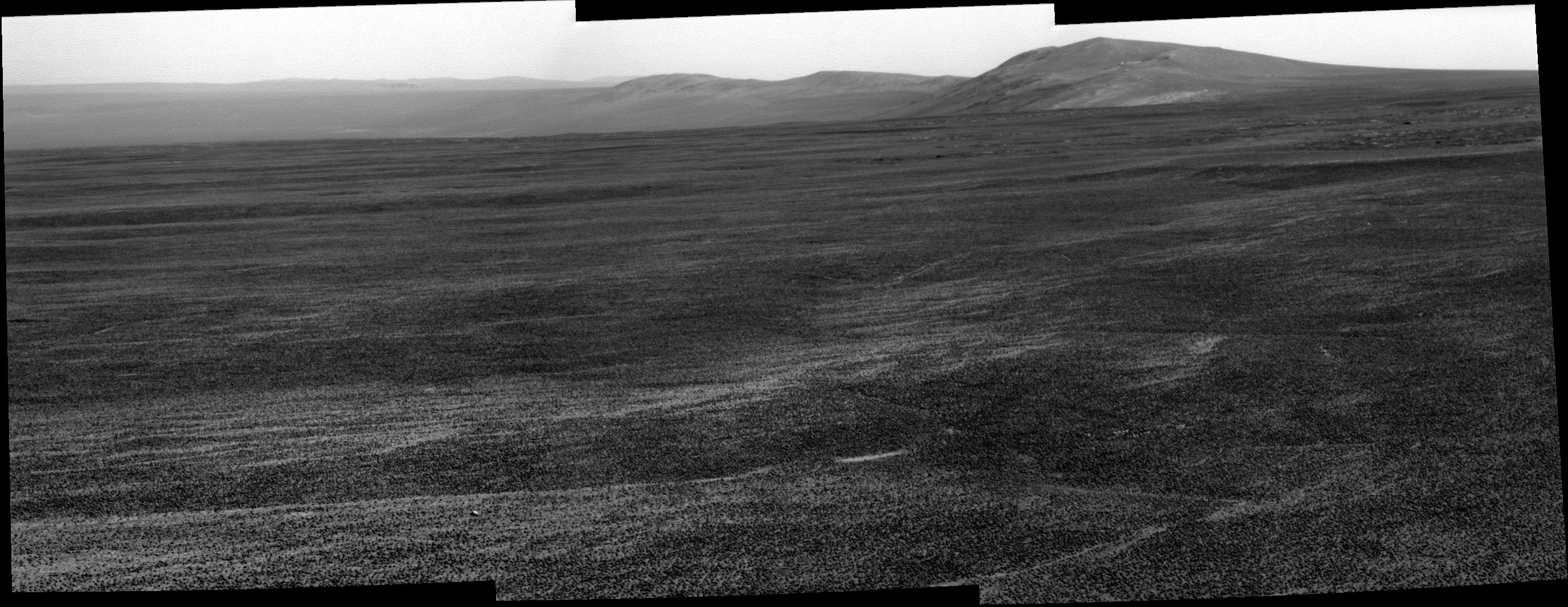
I think compressing Ant's panorama gives much more drama on the view of Endeavour.
(EDIT: Panorama added)
I think compressing Ant's panorama gives much more drama on the view of Endeavour.
(EDIT: Panorama added)
My version of the zoom on the blueberries blanket.
@Ant : I made my last Oppy image processing such a long time ago... It's good to be back here ! And as everyone, I can't wait to see what's below the horizon
@Ant : I made my last Oppy image processing such a long time ago... It's good to be back here ! And as everyone, I can't wait to see what's below the horizon
MoreImput that view looks so amazing. 
Beautiful Ant. Looks like a change in anisotropy here after all these years.
Cape York now easily visible even in the the navcam stamps.
How far are we from Cape York?
QUOTE (neo56 @ Jul 29 2011, 07:17 PM)
My version of the zoom on the blueberries blanket.
@Ant : I made my last Oppy image processing such a long time ago... It's good to be back here ! And as everyone, I can't wait to see what's below the horizon
@Ant : I made my last Oppy image processing such a long time ago... It's good to be back here ! And as everyone, I can't wait to see what's below the horizon
A question: These roundish larger pebbles on top of the blueberries - many with circular pits in them - have we seen these before? I don't recall that we have...
QUOTE (Julius @ Jul 30 2011, 07:18 AM)
How far are we from Cape York?
If I read the map right, a tad over three hundred meters as the Martian bird (bat?) flies, probably more like half a km as the Oppy rolls.
In the sol 2668 blueberry picture, note not just the bimodal size distribution (often seen before), but the high proportion of pits in the big berries. Not sure what to make of that.
At Sol 2668 the nearest point of Cape York was just 311 meters away (direct to the east).
Direct distance to Spirit Point was 522 meters. All according to Google earth.
But we have driven again 65 m more since sol 2668.
Still can't believe we are so close now.
Are we there yet?
Direct distance to Spirit Point was 522 meters. All according to Google earth.
But we have driven again 65 m more since sol 2668.
Still can't believe we are so close now.
Are we there yet?
Another big drop in the horizon on 2670, and it wasn't even a long drive!
http://marsrovers.jpl.nasa.gov/gallery/all...UIP2375R2M8.JPG
http://marsrovers.jpl.nasa.gov/gallery/all...UIP2375R2M8.JPG
We've been talking about this as if we had overestimated the height of Cape York (and we had), but now it looks as if we had underestimated the steepness of the slope down into Endeavour.
Phil
Phil
You really feel like you are looking into the bowl of a crater here:
http://marsrovers.jpl.nasa.gov/gallery/all...IP2375R2M8.HTML
Also, any idea why there are so many data dropouts lately?
http://marsrovers.jpl.nasa.gov/gallery/all...IP2375R2M8.HTML
Also, any idea why there are so many data dropouts lately?
QUOTE (Phil Stooke @ Jul 30 2011, 07:10 PM)
it looks as if we had underestimated the steepness of the slope down into Endeavour.
I estimated slopes of 5 or 6 degrees in Botany Bay based on pgrindrod's contour map, which still looks realistic. If we were looking down a 5.5 degree slope, the slope would appear this far below the distant (true) horizon in pancam:Click to view attachment
So there's still a lot of room for the horizon to drop. My guess is in another few hundred metres, once we get a clear view down the throat of Botany Bay, the view will be really impressive (without Philovision!), and CY will actually turn out to be quite a dramatic "shelf".
I hesitate saying all this since I could be wrong! The view will depend on what the slope does beyond CY. Anyway, we'll soon see...
Here is the colourized version of that image for
better viewing of the slope.
jan van driel
Click to view attachment
better viewing of the slope.
jan van driel
Click to view attachment
For those of you not following me on Twitter two bits of news: Another ~65m drive tosol and that large ripple/dune/mound has been named 'Pathfinder Mound'
Note that the "grain" of the cracks in the sediment now trend parallel to the rim of the crater. The boundaries of the covered-versus-uncovered areas also shows this trend. More extension perpendicular to the rim? Influence of buried topography? We are probably descending thought sediment layers too. The ground slope here is only 1-2 degrees. So far.
QUOTE (Sunspot @ Jul 30 2011, 11:22 AM)
You really feel like you are looking into the bowl of a crater here:
http://marsrovers.jpl.nasa.gov/gallery/all...IP2375R2M8.HTML
Also, any idea why there are so many data dropouts lately?
http://marsrovers.jpl.nasa.gov/gallery/all...IP2375R2M8.HTML
Also, any idea why there are so many data dropouts lately?
"Data dropouts," meaning... what do you mean?

Combination of a few factors...
1) going into Restricted planning mode (as we do every couple weeks)
2) as it seems to me, smaller available relay downlink volumes through ODY and MRO (this is just bad luck, and perhaps there's some selection bias in my estimation)
3) longer latencies in the relayed downlink (again, bad luck)
4) dragons
Mostly the dragons. Mostly.
Though, again, it depends what you mean by "dropouts".
Hi Matt!
I think he meant these black parts like here: http://marsrovers.jpl.nasa.gov/gallery/all...IP2375R2M7.HTML
These parts just haven't been not been received on earth, and will be later send again.
I think he meant these black parts like here: http://marsrovers.jpl.nasa.gov/gallery/all...IP2375R2M7.HTML
These parts just haven't been not been received on earth, and will be later send again.
QUOTE (MoreInput @ Jul 30 2011, 04:08 PM)
Hi Matt!
I think he meant these black parts like here: http://marsrovers.jpl.nasa.gov/gallery/all...IP2375R2M7.HTML
These parts just haven't been not been received on earth, and will be later send again.
I think he meant these black parts like here: http://marsrovers.jpl.nasa.gov/gallery/all...IP2375R2M7.HTML
These parts just haven't been not been received on earth, and will be later send again.
Ohhh, that kind of dropout.
Yup. It's a function of how they choose to prioritize the images and any sub-framing they do.
Exploratorium up and running again...
Okay, this was already amazing. But now, this is going to be epic.
Sol 2671 pancam view
Also navcam, same sol :

Cape York is now obviously visible on the left part of the pan.
I just can't believe what we are living now.
Ps : I will be a little bit out of networks the next week. I will try to continue working on pictures but not sure (internet through 3G network, in the Alps, it can be a little bit random).
Sol 2671 pancam view
Also navcam, same sol :
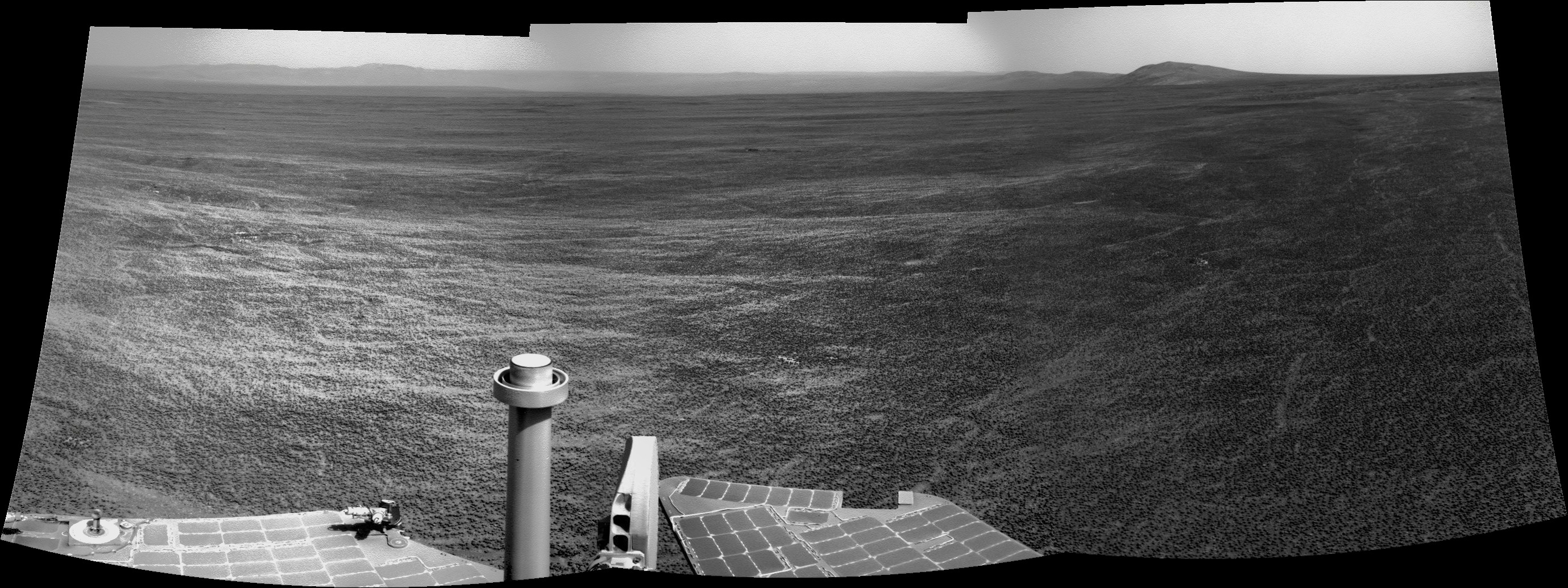
Cape York is now obviously visible on the left part of the pan.
I just can't believe what we are living now
.Ps : I will be a little bit out of networks the next week. I will try to continue working on pictures but not sure (internet through 3G network, in the Alps, it can be a little bit random).
My first panorama, just removed most of the floor to see only the horizon.
This is a "lo-fi" version of our main content. To view the full version with more information, formatting and images, please click here.