It's hard to tell from this distance whether the layering in the central mound is from algorimancer's remnant "beaches" or is from centsworth's layered Meridiani sediments, though my money's on the latter. That could still be analogous to the Gale mound, if you imagine the Meridiani sediments being stripped away from the entire landscape except inside the crater. But maybe the albedo features in the bottom of the trough could be the remnants of a dried-up lake??
There's years of work to do here...
John
Full Version: Post Conjunction: Santa Maria to Cape York
Pages: 1, 2, 3, 4, 5, 6, 7, 8, 9, 10, 11, 12, 13, 14, 15, 16, 17, 18, 19, 20, 21, 22, 23, 24, 25, 26, 27, 28, 29, 30, 31, 32
QUOTE (Bobby @ Aug 9 2011, 02:02 AM) 
. I've all ways wondered if Mars does have any rare metals?
Mars has a fair number of iron meteorites laying around, so there is a fairly decent source of platinum group metals (platinum, palladium, iridium, etc.)
You're not going to spot any gold or silver from orbit, save perhaps the very rare gamma signal from an atom getting zapped, and certainly not enough data from those to build you a distribution map.
QUOTE (centsworth_II @ Aug 9 2011, 08:04 AM)
My opinion (a two cent value!) is that the mound is the same built up sulphate layers that surround Endeavour and cover all of Meridiani that Opportunity has traversed.
I wonder If layering has been noted, from orbital images, in Endeavour's; or any other pre-Meridiani crater with an interior mound? If not:Perhaps confirmation of you opinion, about both the layering and the material of the central mound, would be one more significant achievement of this mission to Endeavour.
QUOTE (john_s @ Aug 9 2011, 03:10 PM)
It's hard to tell from this distance whether the layering in the central mound is from algorimancer's remnant "beaches" or is from centsworth's layered Meridiani sediments, though my money's on the latter. That could still be analogous to the Gale mound, if you imagine the Meridiani sediments being stripped away from the entire landscape except inside the crater. But maybe the albedo features in the bottom of the trough could be the remnants of a dried-up lake??
There's years of work to do here...
John
There's years of work to do here...
John
Just wish that you are right and that Oppy will survive to give us those years for future work and discovery!!
Never bet against a Mars rover, or the amazing people who keep them going back here on Terra.
I mean... just look at how far Oppy has actually driven, compared to how far it was hoped she would drive at the start of her mission...
Click to view attachment

( from: http://roadtoendeavour.wordpress.com/2011/...ng-for-landfall )
I mean... just look at how far Oppy has actually driven, compared to how far it was hoped she would drive at the start of her mission...
Click to view attachment
( from: http://roadtoendeavour.wordpress.com/2011/...ng-for-landfall )
Now that Opportunity is back in full science mode and in a target rich environment, it will take years for her to add the required 5 miles (8km) to complete a 26 mile marathon.
Whats the record for the russian rover on the moon? 35km??
<out of my league warning> is it possible that the mounded center is a result of rebound uplift from the impact? </out of my league warning>
In a word, no. The mound is much too big relative to the crater to be an impact-related "central peak" due to rebound, and in the north it's continuous with the Meridiani plains outside the crater.
John
John
I'm curious to see crism data of the interior of endeavour crater...is there a link?
Thanks for the comments on the colorization of panorama's.
I must admit that the word color is not the right one, it must be colorization.
It's an artistic impression of the colors on Mars. ( DFortes, Walfy )
You like Rembrandt or not, You like van Gogh or not, You like Picasso or not, to name a few.
I have never stated this are the True colors on Mars.
The sole purpose is for better and enjoyable viewing. ( DJEllison )
Others make polar views and others do vertikal stretching, also for better viewing.
For Toma B
It are colorized L2 images from Exploratorium. The L5 and L7 images where not published at that moment.
Let us be happy that so many people follow Spirit and Opportunity on Mars and use the images.
Thanks to Steve Squyres etc. who made this possible.
Jan van Driel
QUOTE (Julius @ Aug 9 2011, 05:03 PM)
Whats the record for the russian rover on the moon? 35km??
Lunokhod 2: 37 km.
Oppy: 33,2 km 3rd August
http://en.wikipedia.org/wiki/Lunokhod_2
Maybe Oppy will get also this record. I think they will do much analysis on different parts of Cape York, and then go south to find more at Cape Trib. It is about 5 km away, so more than 37 km would be possible and also scientifically useful.
From MER Update of 30th June:
http://planetary.org/image/Endeavour_rim_map.jpg
"Cape York is nearly surrounded by exposures of hydrated bedrock. From there, the planned exploration route goes south along the rim fragment Solander Point, to Cape Tribulation, where clay minerals have been detected. "
This map CRISM Map Cape Trib is from cape Trib and Cape Byron in the south, which requires at least 2 km more driving. So the odometer could be here at 40 km.
I think searching the right places, analysing them with the spectroscopes will be very time consuming. Just expect years of exploration ...
QUOTE (jvandriel @ Aug 9 2011, 06:27 PM)
It's an artistic impression of the colors on Mars. ( DFortes, Walfy )
You like Rembrandt or not, You like van Gogh or not, You like Picasso or not, to name a few.
You like Rembrandt or not, You like van Gogh or not, You like Picasso or not, to name a few.
Yes I like some of those artist and dislike some, but I don't see them as ART. Whats the point of ading sepia tone to every image and then calling it colorisation? If you see some artistic value in doing that, thats OK with me...
QUOTE (jvandriel @ Aug 9 2011, 06:27 PM)
For Toma B
It are colorized L2 images from Exploratorium. The L5 and L7 images where not published at that moment.
It are colorized L2 images from Exploratorium. The L5 and L7 images where not published at that moment.
Now I checked again and it is PERFECT FIT. Both of those Ant103 images are from SAME sequence and are L257.
THEY WERE ON THE GROUND much before Ant103's posted his version (Post #1450). Look at this same thread Post #1411 by James Sorenson and Post #1414 by Stu.
Only diference is prefered Color Levels.
Oh, and BTW I actually LIKE those L257 cororisations. Reason why they DO LOOK sometimes unnaturaly yellow or red (or whatever) is because of diferent tipes of monitors and video settings that we use.
QUOTE (jvandriel @ Aug 9 2011, 08:27 AM)
The sole purpose is for better and enjoyable viewing. ( DJEllison )
You're reducing the available detail in tinting it so vividly orange, so quite how it can be 'better' I don't know.
Put a picture of Huygens on one of them. It doesn't look out of place.
QUOTE (djellison @ Aug 9 2011, 01:14 PM)
You're reducing the available detail in tinting it so vividly orange, so quite how it can be 'better' I don't know.
Hi Doug,
If I may offer a thought here.... I suspect your difference of opinion and interpretive value regarding the tinted imagery Jan produces may be more akin to the differences you and Stu have at times, such anthropomorphizing the rovers vs not (does Oppy's heart glow, or is it's WEB just emitting greater in the LWIR than it's surroundings).
I suspect that Jan and others enjoyment of the tinted imagery, their consideration of it as an improvement, lies in the atmosphere, mood, or even sense of place the color evokes. On the other hand I, along with yourself and at least Toma B prefer the the imagery to be as accurate and full a representation of the actual data, the scene as sensed, as possible. Consequently, the heavy tinting is a burdensome obfuscation of the data, a hindrance to the analytical enjoyment of the data in it's fullness (at lease as far as the stretched jpgs allow anyway). Aesthetics vs analytics.
Maybe I'm stating the obvious. Anyway, that is my two cents in hope of easing the discussion a little.
-- Pertinax
I like artistic imagery - hell, I was part of making a rather well reproduced one at the summit of husband hill. I even like colorization (such as the infamous Meridiani dunes + clouds)
This is different. It's bright frickin' orange. It doesn't tick any box of being accurate, pleasant, artistic or an improvement to the data.
ADMIN NOTE:
This is different. It's bright frickin' orange. It doesn't tick any box of being accurate, pleasant, artistic or an improvement to the data.
ADMIN NOTE:
- The discussion of colorization is done.
- Three people have attempted to start new Opportunity threads, without any actual content. They're doing it just to be 'first' with the new thread. Anyone else who does this will get a suspension. A new thread will be made in due course.
On a happier note, I was looking some of the CRISM observations of Endeavour's western rim (http://www.lpi.usra.edu/meetings/lpsc2011/pdf/2272.pdf), and then at Stu's color Hi-RSIE image of Cape York. It will be fascinating to see what the areas with the phyllosilicate signatures look like, both with Pancam and the MI. From the simple visible light view, there seems to be nothing notably different.
Click to view attachment
Further down the road Lord willing, it will an epic adventure if we attempt in-situ obs atop Cape Tribulation. Looking at this image from the above abstract, Cape Trib might be aptly named!
Click to view attachment
Click to view attachment
-- Pertinax
Click to view attachment
Further down the road Lord willing, it will an epic adventure if we attempt in-situ obs atop Cape Tribulation. Looking at this image from the above abstract, Cape Trib might be aptly named!
Click to view attachment
Click to view attachment
-- Pertinax
It seems that the phyllosilicates of Cape Trib are one the wrong side of the hill: Oppy must first climb the hill on the west side and then rope down on the east side. I don't think that a rover can climb onto hills  .
.
.QUOTE (MoreInput @ Aug 9 2011, 12:47 PM)
I don't think that a rover can climb onto hills .
.See Spirit, Husband Hill. Or Opportunity, climbing into and out of Endurance and Victoria craters.
The MER design can, and has, navigated slopes of over 30 degrees.
I am fairly sure at Victoria we saw slopes of 25 degrees or so. Also, if you look at the maps closely, while the main areas of clays look to be on the interior slopes, some also look to be on the exterior slopes near the summit. I half wonder if the summit of CT might not be the richest source in the area.
A tasty snack for a rover next summer? We'll see!
-- Pertinax
A tasty snack for a rover next summer? We'll see!
-- Pertinax
Hopefully there are lots of places where Opportunity can find phyllosilicates, but the saddle between Cape Tribulation and Cape Byron seems particularly rich and easy to get to.
Next summer!
Click to view attachment
Next summer!
Click to view attachment
Is there crism data of the central mound and surrounding interior of endeavour??
ADMIN - You asked the same question less than 6 hours ago : http://www.unmannedspaceflight.com/index.p...st&p=177245 - any real need to ask it again so rapidly?
What s happening behind the scenes? Any news of Oppy driving towards CY yet?
ADMIN - Read this thread. There is plenty of news.
ADMIN - You asked the same question less than 6 hours ago : http://www.unmannedspaceflight.com/index.p...st&p=177245 - any real need to ask it again so rapidly?
What s happening behind the scenes? Any news of Oppy driving towards CY yet?
ADMIN - Read this thread. There is plenty of news.
QUOTE (djellison @ Aug 9 2011, 01:50 PM)
See Spirit, Husband Hill. Or Opportunity, climbing into and out of Endurance and Victoria craters.
The MER design can, and has, navigated slopes of over 30 degrees.
The MER design can, and has, navigated slopes of over 30 degrees.
When talk turns to climbing hills, I have to ask...
How much did the strain of climbing Husband Hill contribute to the failure of Spirit's wheel? If we don't know then, is it worth the risk?
They have already decided to risk climbing, they want to try find evidence of clays. If Oppy breaks a wheel, she breaks a wheel, hopefully right on top of the clays.....
Thanks to all for the images!
I have been looking at a feature on Cape Tribulation. It reminds me of something Spirit saw, half a planet away.
the feature is in the center:
Click to view attachment
Spirit's feature (von Braun)
Click to view attachment
I suspect that aeolian erosion (the dominant time-based erosion mechanism on Mars) creates these features.
The fact that Spirit saw one on a random piece of real estate - and now that Oppy may be looking at a similar example may mean that this type of erosion feature may be all over Mars - of course I may also be wrong.
Your mileage may vary
BTW: I swiped the cape-trib image from ANT's Postcard image (fantastic work, thank you!)
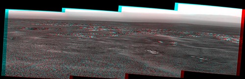
Looks like no new images yet. (Well maybe some thumbnails if somebody is desperate.) As a poor substitute, here's the Pancam mosaic from sol 2677 in anaglyph form, showing what I think is more of Cape York - correct me if I'm wrong, my track record of identifying what we're looking at here is not great.
Taking the stretched version of the pan by Mike Howard and trying to guess where the CRISM data registers, here's a hack overlay:
Red shows pyllosilicates, green hydrated minerals.
Click to view attachment
(We gotta go way up that "hill")
Red shows pyllosilicates, green hydrated minerals.
Click to view attachment
(We gotta go way up that "hill")
I'm wondering if the circumferential "zones" around CY are more chemical in nature... See post in "Geomorphology of Cap York" thread...
Nice composite! I'm hoping that those big rocks at Odyssey are full of phyllosilicate too- I doubt that CRISM would be able to resolve them, so it's possible.
John
John
Magnificent view! What an amazing experience these rovers have given us.
QUOTE (john_s @ Aug 10 2011, 03:10 AM)
I'm hoping that those big rocks at Odyssey are full of phyllosilicate too- I doubt that CRISM would be able to resolve them, so it's possible.
From Pertinax post 1517 the phyllosilicates seem concentrated in the ejecta around the old crater in the centre of CY so there's a pretty good chance.
QUOTE (Julius @ Aug 9 2011, 02:25 PM)
What s happening behind the scenes? Any news of Oppy driving towards CY yet?
Here's your news...
A new drive executed today, only a few hours ago. I do not know exact sequenced distance, but it was an approach drive to the Odyssey crater. It will take at least 1 more "bump" drive to get her within IDD distance. We will presumably be planning another drive tomorrow, to start executing a bit after that. But again, that's only my guess, and it's as good as yours. Tactical ops can change quickly.
That's about all I know.
-m
Moved a couple of posts to the Cape York thread. We're there now folks!
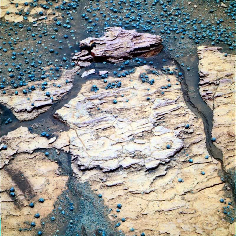
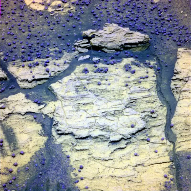
"Gibraltar" in 3D turns out nicely.
Click to view attachment
On the right side, it looks like a mini-rivulet of sorts!
Click to view attachment
On the right side, it looks like a mini-rivulet of sorts!
QUOTE (walfy @ Aug 11 2011, 01:08 PM)
it looks like a mini-rivulet of sorts!
By
 Joke aside, is it possible to imagine a wind mechanism capable of creating such a feature? It really looks sharp, so it must be relatively recent. Also, which way is downslope on that image?
...Or is it a mini-graben from the movement of the two large slabs?
Meanwhile, I'm liking the sticky-out layer on the left side of the rock at the back. Nothing says dry and windy and ancient more than features like that!
Andy, who would be instinctively snapping those off if there: it's a sort of geological involuntary bubble-wrap popping thing that I have.
Meanwhile, I'm liking the sticky-out layer on the left side of the rock at the back. Nothing says dry and windy and ancient more than features like that!
Andy, who would be instinctively snapping those off if there: it's a sort of geological involuntary bubble-wrap popping thing that I have.
QUOTE (walfy @ Aug 11 2011, 08:08 PM)
"Gibraltar" in 3D turns out nicely.
And in colors too
I don't think I have ever said WOW on this forum before, but I am now, over that 3-D view of Gibraltar. I am especially wowed by the rivulet feature on the right. It has undercut sides and overhanging edges, which in places have been so undermined that they have broken off. A flat-topped piece of the "plain" above has tumbled down intact to rest on the bottom. It just looks SO like a small rivulet freshly carving out wet sand on a beach....
To me it looks bone dry and not like a rivulet at all. I see no meander.
Thanks to the MER people for finally bringing us to a Mars worthy of Bonestell!
Thanks to the MER people for finally bringing us to a Mars worthy of Bonestell!
QUOTE (Ant103 @ Aug 11 2011, 08:08 PM)
And in colors too
Beautiful picture Ant ! Particularly when only L6-L7 and R1 to R7 filters are available on the exploratorium

QUOTE (Oersted @ Aug 11 2011, 09:28 PM)
To me it looks bone dry and not like a rivulet at all. I see no meander.
It depends on the orientation of the scene. If it's tilted down towards the left and away from the viewer, then any fluid would presumably follow the edge of the hard rock, as the "rivulet" clearly does. I'm not saying it's a liquid, it might be wind or a heat effect off the rock. But a liquid rivulet could look like that, I think. Others will know better than I.
To me, that feature along the right side of Gibraltar does not look like the result of flow. It looks like a mini-fault resulting from movement of the rock. There is a similar, smaller, feature on the left side and also indications of the result of movement along the top. It looks like the whole rock moved (mostly subsided) disturbing the sand all around its edge.
Most of the blueberries seem to have holes in them.
QUOTE (neo56 @ Aug 11 2011, 10:31 PM)
Beautifu picture Ant ! Particularly when only L6-L7 and R1 to R7 filters are available on the exploratorium
Other filters are available, look at the upload directory for the 10th. My take on "Gibraltar":
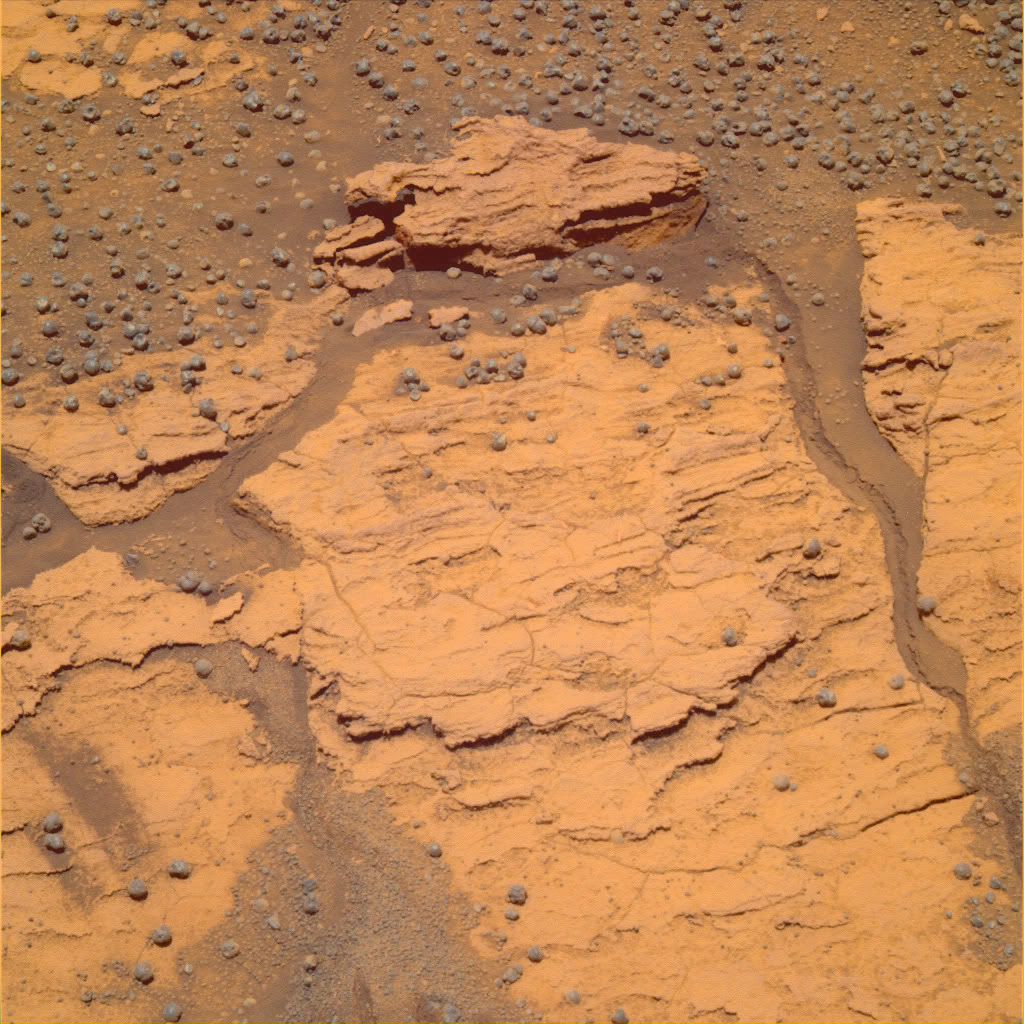
RE: Gibralter
Going just from casual memory, and not speaking as an expert, I think we have seen these 'depression' or "subsistence" outlines many times before - but not with such sharp edges! Maybe a crust covering the soil?
Going just from casual memory, and not speaking as an expert, I think we have seen these 'depression' or "subsistence" outlines many times before - but not with such sharp edges! Maybe a crust covering the soil?
Is it possible this fissure formed when Opportunity ran over the adjacent piece of rock and displaced it? We've seen similar things before.
Also, as Gibraltar was (I think) a pre-Cape York target, shouldn't it be in the "Post Conjunction..." thread? I understand why that thread was closed to encourage people to move to the new thread, but now that goal has been accomplished, shouldn't it be re-opened for posting of continued discussion of data from the long trek?
John
QUOTE (john_s @ Aug 11 2011, 04:03 PM)
Is it possible this fissure formed when Opportunity ran over the adjacent piece of rock and displaced it? We've seen similar things before.
Not out of the question.
There was interest in Wednesday's planning meetings (executing... now, if I am right) in looking back at some because they noticed the wheels had crushed something. Probably a different thing than what you're talking about, but nonetheless it makes the point that it's easily possible.
-m
QUOTE (Sunspot @ Aug 11 2011, 03:25 PM)
Most of the blueberries seem to have holes in them.
More like pitted olives than blueberries, maintaining the edible fruit theme. The concretions may have nucleated around something not as hard, but I'm struggling to come up with a mechanism that would expose the center to weathering from just one side.
QUOTE (john_s)
Is it possible this fissure formed when Opportunity ran over the adjacent piece of rock and displaced it? We've seen similar things before.
Most likely. And this site has other interesting items. Note the rock fragment in upper center, purplish-and brown. As well as the dimpled blueberries.Gibraltar, L257, Sol 2670
Gibraltar, R721, Sol 2670
--Bill
From hazcam the left hand wheel ran over the edge of the left hand rock (which seems an integral part of the right hand rock) providing a lever action and the crack outlines the edge of the rock.
For my part the rock at the top of the image seems much more interesting than a mechanical artifact. The left hand tip has broken off revealing what looks like a fill and the implication is that the fill was not bonded in any way to the matrix since it seemingly broke away along the fill boundary. The color of the fill is different to the berries and the rock has that 'burplish' coloration that we have been seeing with increasing regularity, and which makes me wonder about the cation 'flavour' of some of the sulphates.
Edit: Apologies. Magnification shows this is just an overhang with s shadow and upper lit section in the background giving an illusion of fill.
This is a "lo-fi" version of our main content. To view the full version with more information, formatting and images, please click here.