diane
Jun 22 2011, 06:43 PM
QUOTE (Ant103 @ Jun 22 2011, 09:40 AM)

the biggest crater ever seen
That would be Gusev crater (166 km), not Endeavor (22 km). But we never saw Gusev from its rim.
kenny
Jun 24 2011, 08:35 AM
So we are now just a little over 2km from Spirit Point. I'm slightly mystified that we don't seem to have the great view (HOV or whatever was the acronym) that has been predicted for the past Earth year or so.
I believe there is a rise ahead blocking it in part, then a further dip, but I'm beginning to suspect the elevations of the crater rim are going to appear as gentle undulations rather than stupefying verticality...
Stu
Jun 24 2011, 09:43 AM
I don't think anyone's ever expected, or predicted, "stupefying verticality", because that's impossible. If you look at this pic...
Click to view attachment...you'll see that we are still 3.6km away from the Tribulation Hills, and once we reach Spirit Point the cratered hills on the far side of Endeavour will just be 2km nearer than we are now, they'll
still be 21km away. That will hardly change their appearance at all. So no-one's expecting them to suddenly stretch vertically and rear up like some eagle-circled crags from Middle Earth. What will change, and where I think we'll get that HOAV, is we'll see a) deeper down into the crater, exposing the lower parts ofthose hills, and 2) we'll have a much wider angle view, seeing the lower hills on either side of that main hill. We'll also be able to "look down" the Tribulation range, which I think will be pretty cool.
Phil Stooke
Jun 24 2011, 09:57 AM
Tribulation is going to be fairly stupefying. It's only Cape York that will dazzle us with its horizontality. But I think there will still be lots to see. For one thing, we may end up looking at it from close to its downhill side, or at least end-on. And the far side hills will look totally different when it's not just their tips we are looking at.
Phil
kenny
Jun 24 2011, 01:10 PM
Thank you both for your analyses, which if not quite stupefying, are certianly dazzlingly apposite. Whatever, there will indeed be lots to see once we crest the rise.
(this really ought to cross-refer to Distant Vistas, but I imagine most followers will be scanning both Topics.)
ElkGroveDan
Jun 24 2011, 01:20 PM
QUOTE (Phil Stooke @ Jun 24 2011, 01:57 AM)
It's only Cape York that will dazzle us with its horizontality.

I'd say that we're fairy drunk on horizontality by now -- going back to before oh......
Rub al Khali.
fredk
Jun 24 2011, 01:57 PM
I'm definitely expecting a dramatic change in our view soon. Looking at the latest pancams:
http://qt.exploratorium.edu/mars/opportuni...2M2.JPG?sol2635compared with just a few sols ago:
http://qt.exploratorium.edu/mars/opportuni...2M1.JPG?sol2630you can see that we've dropped a bit. Looking at the orbital view, you can see that we're skirting an ancient, heavily eroded crater basin. Once we get up on to the exposed bedrock ahead, I'm sure the view will start to open up. And that's only about half a km!
In addition to the topography, I'm also looking forward to seeing some interesting albedo features, like the vast dark dune fields in the south of Endeavour. But the deepest part of Endeavour is around 500 m below the rim - that's serious topography for Meridiani!
ElkGroveDan
Jun 24 2011, 03:53 PM
Agree. I've had a pin on my GM for a while now that is essentially the "no question about it" point where we will see Cape York. As far as I can tell it's no more than two or three fair drives from where we are now.
eoincampbell
Jun 24 2011, 04:02 PM
I agree that jaws start dropping around
Stu's flag
Sunspot
Jun 24 2011, 08:12 PM
Tesheiner
Jun 24 2011, 08:33 PM
I presume the "bump" to the left of it is "Cape Approach" crater, the feature we have been following from some time ago. In that case, Cape York must still be located to the left of the crater. Check
here.
NW71
Jun 24 2011, 09:47 PM
QUOTE (Tesheiner @ Jun 24 2011, 09:33 PM)
Cape York must still be located to the left of the crater. Check
here.
Is that the case even though we're driving backwards?

Neil
Stu
Jun 25 2011, 12:37 PM
Purely for fun, not claiming any scientific accuracy or nuttn, here's (red flag) where I think we'll see Cape York properly for the first time...
Click to view attachmentMore coffee- and spicy Nik Nak-fuelled speculation here...
http://roadtoendeavour.wordpress.com/2011/...first-view-soon
Sunspot
Jun 25 2011, 01:20 PM
The blue numbers in that image represent height? If so, I would say Cape York is going to appear quite suddenly and dramatically.
Stu
Jun 25 2011, 01:28 PM
No, the blue numbers are distances between points in metres.
Tesheiner
Jun 25 2011, 02:29 PM
QUOTE (Stu @ Jun 25 2011, 02:37 PM)
... here's (red flag) where I think we'll see Cape York properly for the first time...
It might be at that point or perhaps a few hundred meters further but in any case we are talking about
just a few weeks (three, two, one?) in the future.


PS: Those of you planning to leave on vacations this next month should stay always close to a cybercafe.
pgrindrod
Jun 25 2011, 02:37 PM
Been meaning to do this for a while - time to dust off my HiRISE DEM of this area...
Below is an animation of the calculated visible terrain from Oppy (1.5 m off ground) at different points in the traverse. Starting at the position as of Sol 2635, and moving towards the general direction of Cape York.
In these images, pink = not visible, green = visible. The red dots are the previous positions (from Tesh's awesome KML files, imported into ArcGIS), with an extra dot showing the approximate highest point of Cape York. The green dot is a moving Oppy from which the visibility is calculated. The striping is a result of the DEM-build process and the HiRISE CCD strips. And as this area is so flat the method is fairly sensitive to noise in the DEM on the scale of about a metre or so (this means that there could be small local highs or lows affecting the result).
Anyway, safety warning over, here goes...
Click to view attachmentIf this is right, then it seems like Cape York won't appear until we really are right on top of it. I make it about another 1.5 km until it should pop up, or about 500 m away from Cape York itself.
Well, there's my reputation on the line, let's sit back and watch the horizon!

Pete
marswiggle
Jun 25 2011, 02:53 PM
For those in possession of red-and-blue glasses, a glance at this image (with 'X' over Oppy's last position) reveals immediately why we can't see Cape York yet. However, the rise between us and our destination is so evenly swine-backed (convex) that I find it next to impossible to evaluate when or where our first sighting of the Cape will occur. But anyways, I think this must happen before our arrival at the 'Approach Crater'.
Stu
Jun 25 2011, 11:03 PM
jvandriel
Jun 26 2011, 11:20 AM
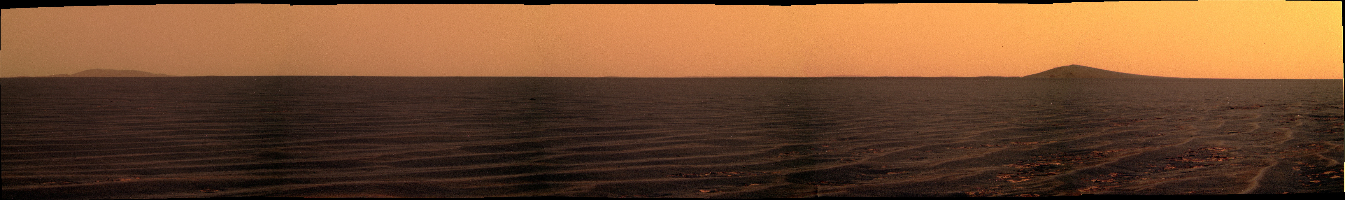
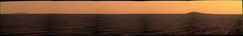
Panoramic view on Sol 2636.
Taken with the L2 Pancam.
Jan van Driel
Click to view attachment
eoincampbell
Jun 26 2011, 06:35 PM
From Google Mars, the terrain between "Approach" crater and Cape York appears suspiciously void of ripples yet the dust/soil coating appears thick enough (for a Spirit style trap) and has a subdued mottled look. I wonder if Oppy needs a toe-dip in this stuff ?
fredk
Jun 26 2011, 07:18 PM
QUOTE (eoincampbell @ Jun 26 2011, 06:35 PM)
suspiciously void of ripples
We've crossed a lot of ground (around Santa Maria) that was basically free of ripples.
The ground in the final approach to CY does look different from the standard Meridiani plains. But I'd think that's because of the topography which starts to drop into Endeavour, and possibly different bedrock geologically speaking. That's another thing I'm looking forward to seeing up close...
Oersted
Jun 27 2011, 12:13 AM
QUOTE (marswiggle @ Jun 25 2011, 04:53 PM)
For those in possession of red-and-blue glasses, a glance at this image (with 'X' over Oppy's last position) reveals immediately why we can't see Cape York yet.
Thanks, that is really great. Get out those glasses for those of you who haven't yet!
serpens
Jun 27 2011, 03:14 AM
Although a x-eye version would do the job for those of us without the glasses.
Stu
Jun 27 2011, 05:15 AM
There's no reason for anyone *not* to have glasses nowadays. Go into your local newsagent/magazine retailer, or discount bookshop and there'll be two or three kids mags or books about 'horrible bugs', 'terrible dinosaurs' or 'creepy crawlies' with 3D pics and glasses, I guarantee you.
djellison
Jun 27 2011, 05:21 AM
Hell - drop an email to a NASA center - they'll send you some for nothing.
marswiggle
Jun 27 2011, 12:44 PM
Ok- as requested, here is an x-eye version of that anaglyph, showing a slightly smaller area, in smaller size. Somehow x-eyed images do not quite work for these vast flat surfaces, for me at least, and they also take up more surface area and thus it takes more file space to post one. For which reasons I am confining myself to anaglyph viewing (and occasionally posting them).
Edited with addition: Anyone who has difficulties with 3D images, and everyone else too, please check pgrindrod's more advanced visibility analysis in post #667 which is based on the same HiRISE data (and which has been undeservedly neglected in the commentary!).
MarkG
Jun 27 2011, 02:38 PM
...A few of us do not have binocular fusion, and thus the glasses are no help...
(cross-eye pics don't work either)
...but don't stop posting....
Ant103
Jun 27 2011, 04:22 PM
<Mr Cobb> We need to go closer !
Sol 2636 color pan.
Tesheiner
Jun 27 2011, 06:10 PM
Sunspot
Jun 27 2011, 06:24 PM
It must be

Stu
Jun 27 2011, 06:28 PM
Ooooooooooh! I SO want to should "Land Ho!!!!" but I guess we should wait to be sure...?
fredk
Jun 27 2011, 06:46 PM
I noticed that too! I guess we're all scrutinizing the horizon these days.
I'm pretty sure it's a bit of the far rim. We're still dropping into a local basin, so the far-rim features are disappearing and they may look unfamiliar. The bit Tesheiner pointed out was more visible on 2633:
Click to view attachmentBefore we have a chance to start seeing CY, the local horizon has to start dropping first. And it will probably be still some time after that before we see CY. I think we'll start getting interesting views of the interior of Endeavour before we see CY.
jamescanvin
Jun 27 2011, 07:06 PM
I was just preparing a post and graphic to say the same thing as Fredk but I needn't bother now.
Sorry folks far rim for that one, we are going to have to wait till after some OMFFSM views of the far rim before we see Cape York IMO. At the moment our view of the far rim is pretty poor.
James
Phil Stooke
Jun 27 2011, 07:10 PM
Nice acronym James - hadn't encountered that one before!
Phil
Pertinax
Jun 27 2011, 07:20 PM
I absolutely agree with you Fred. After looking at the HiRISE CY Anaglyph (and x-eyed which for reasons unbeknownst to me personally produces a more discernabloe or 'vivid' representation of Δz) a bit this morning I became increasingly convinced with that our first solid views of Cape York will come within 100m *after* Close Approach Crater. Going back and looking at Pete's animation further gave me confidence in that regard. I would admit that a couple of pixels worth of CY's highest reaches may be intermittently visible ~150m before CA, but again no solid view until just after driving past CA.
My two cents for what their worth

-- Pertinax
Stu
Jun 27 2011, 07:44 PM
Agree with "First Solid Views after Approach Crater" (v chuffed everyone's using my nickname, BTW!) but I still think we'll see a hint of a glimpse of something poking over the horizon around where I've planted my little red flag...
Tesheiner
Jun 27 2011, 08:52 PM
QUOTE (fredk @ Jun 27 2011, 08:46 PM)
I'm pretty sure it's a bit of the far rim.
That was my second thought, basically because it was so faint in relation to the foreground and to Approach Crater, but had no time to search for older pictures.
Ant103
Jun 27 2011, 09:24 PM
I totally sure that is the far rim we see there. Nothing more. Just a game of the ripples that make rise and set some far hills.
This view -one of those of the last set of pic sended to the exploratorium- freaked me out a little bit :

Had the impression of seeing the mast of cameras from the rear side

Stu
Jun 27 2011, 09:44 PM
You can see just how much of a local dip we're in if you compare the view of the Far Hills from Santa Maria to the view we have now...
Click to view attachment
ngunn
Jun 27 2011, 11:34 PM
Another great comparison Stu. In fact we saw even further down into Endeavour before we descended to Santa Maria. Let's wait for all that again before expecting Cape York. Thanks pgrindrod for post 667! I was hoping you'd reappear with one of those.
djellison
Jun 27 2011, 11:47 PM
QUOTE (pgrindrod @ Jun 25 2011, 07:37 AM)
If this is right, then it seems like Cape York won't appear until we really are right on top of it. I make it about another 1.5 km until it should pop up, or about 500 m away from Cape York itself.
I concur. :0)
nprev
Jun 27 2011, 11:57 PM
Hmm. That may be quite a dramatic moment, then...definitely something to look forward to!
Stu
Jun 28 2011, 09:28 AM
QUOTE (ngunn @ Jun 28 2011, 12:34 AM)
In fact we saw even further down into Endeavour before we descended to Santa Maria.
Yep, we did...
Click to view attachment
Tesheiner
Jun 29 2011, 09:38 AM
Is it just me or the exploratorium is somehow "broken"? I'm getting a "forbidden access (error 403)" warning page.
Now, on the
topic, sol 2640 was supposed to be one of those but, as I can see, only a few tau measurements were taken, no driving; perhaps it's again a case of uplink problems so only "run out" sequences were executed.
SFJCody
Jun 29 2011, 10:11 AM
Same for me. Looks like exploratorium is down.
MahFL
Jun 29 2011, 10:25 AM
Seems to be down.
ngunn
Jun 29 2011, 11:06 AM
QUOTE (Stu @ Jun 28 2011, 10:28 AM)
Yep, we did...
I think it's possible that the near rim 'horizon' we had back then was actually the final crest, beyond Approach Crater, identified by pgrindrod as the point where the view really opens up. Some of the small craters we're visiting along the way may even be detectable in that view.
Phil Stooke
Jun 29 2011, 01:40 PM
Coming up to a holiday weekend in the United States... so presumably, as before, Opportunity will find a nice quiet spot to do a bit of IDD work for a few days. I hope there's something interesting in view.
Phil
pgrindrod
Jun 29 2011, 03:43 PM
Turning this whole horizon spotting thing on its head - what can you see from the top of Cape York?
Taking a whole bunch of points at and around the highest point, I worked out the visibility from there.
Click to view attachmentTurns out there isn't a lot to see on the western side of Cape York (although the view east will I'm sure be spectacular), and that means that it really does seem like we won't see it for a while yet.
Sorry Stu, I can't wait for things to pop up either, but I have been wrong many times before so I reckon we keep watching the horizon (is this the planetary version of "first one to see the sea wins"?)
Pete
This is a "lo-fi" version of our main content. To view the full version with more information, formatting and images, please
click here.