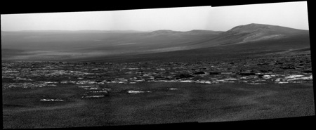
So by my reckoning the tracking data puts us very close to that hump that we were debating yesterday, right on Botany Bay. This should be spectacular!
climber, expect images at 01:35UTC, too late for me dammit!
Full Version: Post Conjunction: Santa Maria to Cape York
Pages: 1, 2, 3, 4, 5, 6, 7, 8, 9, 10, 11, 12, 13, 14, 15, 16, 17, 18, 19, 20, 21, 22, 23, 24, 25, 26, 27, 28, 29, 30, 31, 32
I hope we will really get a bunch of images. 
QUOTE (jamescanvin @ Aug 4 2011, 10:14 PM) 
climber, expect images at 01:35UTC, too late for me dammit!
I'll probably still be up by then, the way this book editing is going...

If anyone wants to bring me over a coffee around 02.00 that would be great, thanks...
Thanks to all time-keepers, data-trackers and image-smiths once again... what drama here ! 
About two hours until we might see some images. The suspense is killing me.

Should really open up after thisol's drive.
There was a big debate yesterday about taking some extra post-drive pancams off to the northeast to get an image and range data for the "path A" entrance on Cape York. If we don't like the terrain on the easterly side of Cape York after approaching from Spirit Point in the south, we have the backup plan of scooting back around to the west side and approaching from that direction (effectively towards the center of the crater). We'll see.
I'll have a nice big new blog post up tonight about the debate. Some great tradeoff discussions went down.
-m
Excellent. Looking forward to it, and really enjoying the blog. And from watching the rovers so long, we've probably learned that patience will be rewarded.
I bet this shows the big rock on the edge of the crater at Spirit Point!
Fantastic pancams and one of Stu's rocks/boulders shows up in the navcams. [edit] John's a quicker poster.
Stu -- Wake up! Wake up! You have to see this tonight!
Stu -- Wake up! Wake up! You have to see this tonight!
Do you think we will end up climbing Cape Tribulation?
http://qt.exploratorium.edu/mars/opportuni...YMP2381R2M1.JPG
http://qt.exploratorium.edu/mars/opportuni...YMP2381R2M1.JPG
QUOTE (fredk @ Aug 4 2011, 05:37 PM)
Awwwwwwwwwww snap.
Viewing the navcams in stereo helps a lot to visualize what's what:
Click to view attachment
Here's my identifications - that "central mound" is the vast dark dunes(?) in the centre of Endeavour, around 10 km away!
Click to view attachment
Agreed about the rocks, John.
What an incredible vista.
Did someone get Stu a coffee?!
Click to view attachment
Here's my identifications - that "central mound" is the vast dark dunes(?) in the centre of Endeavour, around 10 km away!
Click to view attachment
Agreed about the rocks, John.
What an incredible vista.
Did someone get Stu a coffee?!
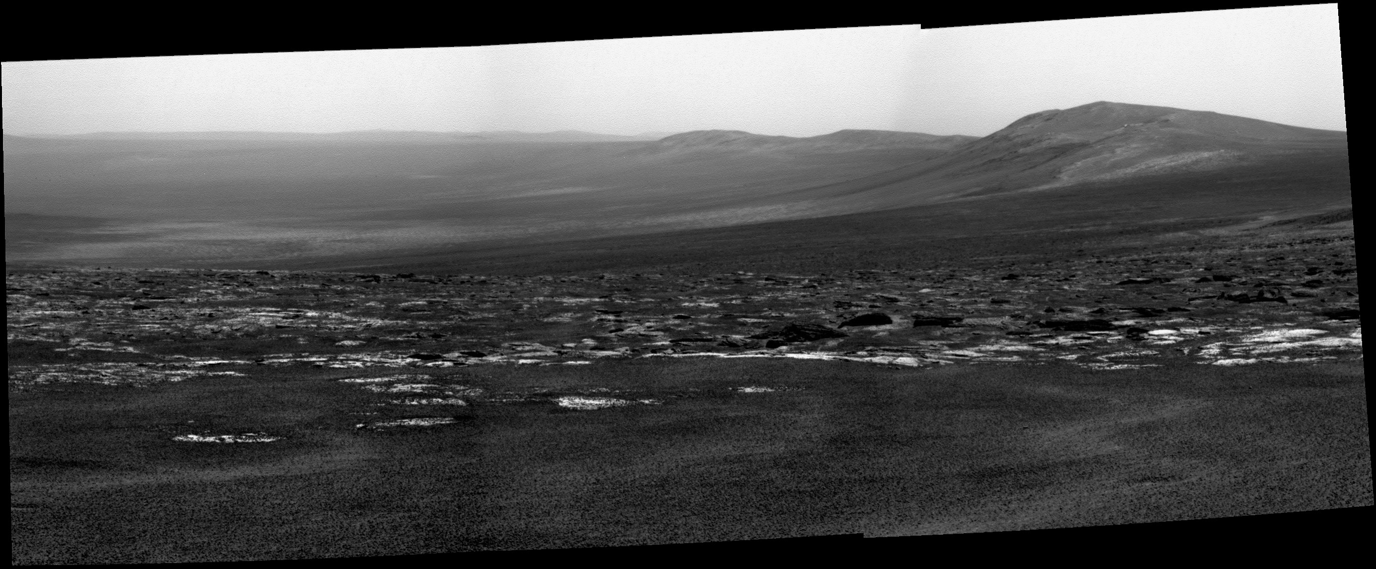
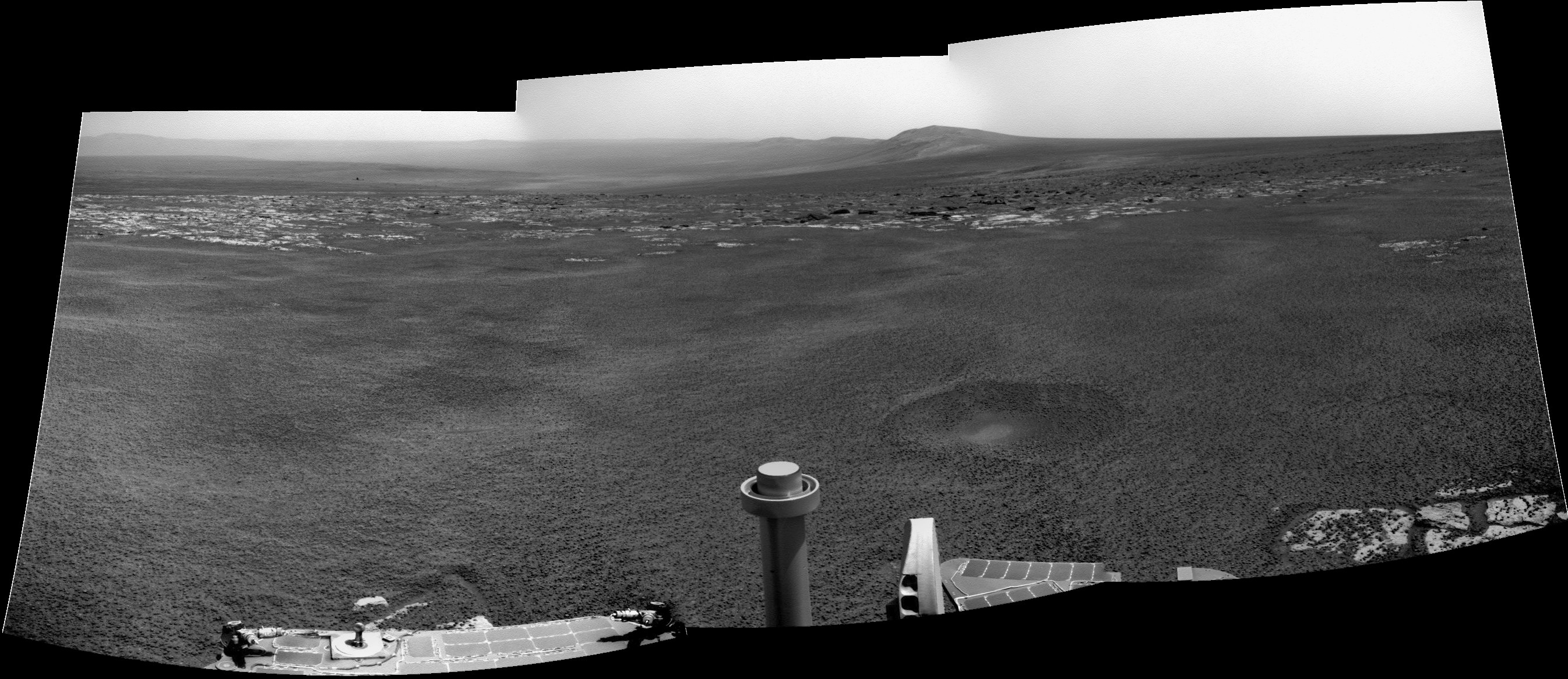
The Pancam mosaic almost perfectly spans the width of Botany Bay, with the end of Spirit Point at the left edge and the end of the promontory bounding the south side of the bay (which needs a name- I don't think it has one yet), at the right edge of the mosaic.
Here's my crude orientation diagram...
Click to view attachment
Here's my crude orientation diagram...
Click to view attachment
Couple quick ones. Navcam:

Pancam:

Edit: redid them in rover frame-of-reference, since the rover seems pretty level but the rover orientation data is way off.
Pancam:
Edit: redid them in rover frame-of-reference, since the rover seems pretty level but the rover orientation data is way off.
OMG!!! at all the Stunning Views everyone has posted here.
The Scientist and Drivers at JPL must be shaking their head's and wondering what decisions to make now.
A part of me would like to see Oppy drive down as far as she can into Endurance Crater
but climbing the hill nearby sounds more exciting. The view from up there would be
Spectacular.
Does anyone know how deep Endurance Crater is and is that bedrock I see at the bottom of the crater???
Amazing! Too bad I have to go on vacation tomorrow. Stupid vacations!
Phil
Phil
QUOTE (Phil Stooke @ Aug 4 2011, 09:12 PM)
Stupid vacations!
That's what they invented laptops for! But don't worry... I'm confident it will still be unfolding when you get back.
(yawn)
Fell asleep at around 1.45, writing about sporadic meteors (well, you would, wouldn't you...)
Did I miss anything?
Fell asleep at around 1.45, writing about sporadic meteors (well, you would, wouldn't you...)
Did I miss anything?
Did you miss anything Stu???
No you didn't. Get ready for The Magical Mystery Tour to Begin.
The Tour has: Blueberry Fields Forever, Endurance Lane, & All you need
is Stu.
No you didn't. Get ready for The Magical Mystery Tour to Begin.
The Tour has: Blueberry Fields Forever, Endurance Lane, & All you need
is Stu.
Lordy, what a stunning vista! We can really look across! I think we're finally "there yet."
Is that rock flagging us to come thither really the big one at the Spirit Point crater? I've given up trying to identify features for now, always proven wrong.
Maybe these new and dangerous rocks are the phyllosilicate-bearing outcrops.
Is that rock flagging us to come thither really the big one at the Spirit Point crater? I've given up trying to identify features for now, always proven wrong.
Maybe these new and dangerous rocks are the phyllosilicate-bearing outcrops.
Here's an animated GIF image composed of 3 Philovisioned panoramas from sols 2671,2674 and 2676. These 3 sols were "driving days" with each drive being approximately 120 meters long. It clearly shows how horizon droped and shows bottom of the Endeavour crater.
Click to view attachment
Just for esthetics of it I added middle image (sol2674) at the end of animation, so that it would cycle back and forth continuously. Hope you will like it.
And sorry for my Tarzan like english. It's not my native language.
Click to view attachment
Just for esthetics of it I added middle image (sol2674) at the end of animation, so that it would cycle back and forth continuously. Hope you will like it.
And sorry for my Tarzan like english. It's not my native language.
If this rock really is the big one at Spirit Point Crater, than it's just the tip of the iceberg, maybe. It rests on the other side of the crater, which is still down slope and somewhat out of view.
That's going to be a fantastic rock to check out up close
That's going to be a fantastic rock to check out up close
 Another 'cheap and fast' colourisation.
Click to view attachment
Looking forward to see the real, full, all-filter colour mosaic that they'll take of this amazing place.
Thanks to everyone on the MER team.
Thanks, Toma. very cool sequence.
I also made this slightly deformed version of that GIF animation.
Click to view attachment
In this one, there is a deformed image from sol 2676. I did this to align Cape Tribulation and hills behind it to same features on previous sols. Effect of droping horizon looks even better this way or at least I think that.
Click to view attachment
In this one, there is a deformed image from sol 2676. I did this to align Cape Tribulation and hills behind it to same features on previous sols. Effect of droping horizon looks even better this way or at least I think that.
QUOTE (Bobby @ Aug 5 2011, 05:08 AM)
Does anyone know how deep Endurance Crater is
About 600m from the bottom to the highest rim IIRC.
QUOTE (mhoward @ Aug 5 2011, 06:09 AM)
QUOTE (Phil Stooke @ Aug 4 2011, 09:12 PM)
Stupid vacations!
That's what they invented laptops for!
Right what I'm doing now.

@TomaB: Fantastic animations!
Dreamed of a view like this since I was a kid, looking at an old Viking issue of National Geographic in an art class at school..
Click to view attachment
Click to view attachment
Just an EPIC sighting !
My own panoramics.

My own panoramics.
Setting the drama level up (Ants panorama):
[quote name='Stu' date='Aug 5 2011, 05:42 AM' post='176871']
Dreamed of a view like this since I was a kid, looking at an old Viking issue of National Geographic in an art class at school..]
I hear ya, Stu.
From Mariner 4 (when some folks declared Mars a boring copy of our Moon) to this! What a road to travel.
I keep pinching myself.... but this IS real!
wow................... thanks MER team and thanks UMSF....
just wow
Craig
One of these folk maybe was Presidente Lindon Johnson...by the expression of his face when he received the picture from the director of NASA at that time!
But they were so wrong!!!These images from valiant Opportunity prove it by far!
Thanks everyone for make this time a so wonderfull time to live!
Humanity made for dreaming, loving and explore!
But they were so wrong!!!These images from valiant Opportunity prove it by far!
Thanks everyone for make this time a so wonderfull time to live!
Humanity made for dreaming, loving and explore!
This is only my second post in many years (I visit every day), and I just have to say a giant Endeavour-sized thanks to everyone at UMSF for the pictures, commentary, insight and enthusiasm--and of course, the MER team for making this possible. What an epic adventure!!

-(Another) Phil
-(Another) Phil
Holy cow. Love those GIFs. I'm spreading them to the MER team today!
This is just plain AMAZING!
Thank you all for those stunning pictures!
By the way, isn't it time for a new topic? Maybe "The Endeavour Adventure" or something else
that sounds good! =)
Thank you all for those stunning pictures!
By the way, isn't it time for a new topic? Maybe "The Endeavour Adventure" or something else
that sounds good! =)
QUOTE (Phil Stooke @ Aug 4 2011, 10:12 PM)
Amazing! Too bad I have to go on vacation tomorrow. Stupid vacations!
Phil
Phil
Same here! I leave for two weeks today. But I got myself a smart phone this week so I can keep up with the amazing images and updates that keep rolling in. Not saying that's the only reason I got it... I think I might find other useful things to do with it. Eventually.
Simply amazing. Something about a mountain range on another planet just resonates, and thrums that sense of wonder I've had for space exploration since I was a kid.
Steve Squyres must be a happy man! Arent we all!
QUOTE (john_s @ Aug 4 2011, 09:49 PM)
the promontory bounding the south side of the bay (which needs a name- I don't think it has one yet), at the right edge of the mosaic.
Are you referring to what looks like a mostly flat shelf like object with a few bumps on it that is pictured on page 2 of HIRISE ANALYSIS OF THE WESTERN RIM OF ENDEAVOUR CRATER
www.lpi.usra.edu/meetings/lpsc2011/pdf/2272.pdf
The reason I ask is that object appears to only be about a 100 meters distant from Spirit point! I call it (Botany Bay) Island. Actually I never called it anything. I just made that up now.
QUOTE (Bobby @ Aug 4 2011, 08:08 PM)
Does anyone know how deep Endurance Crater is and is that bedrock I see at the bottom of the crater???
Good question Bobby. Opportunity is sitting at a Mars elevation of roughly -4800 feet. The lowest point in Endurance is around -6480 feet, so the elevation drop you are looking at is in the neighborhood of 1200 -1500 feet.
The crater floor is definitely tilted to the right from Opportunity's perspective, making it lower in the South.. That would mean the lowest point should be within the field of view of latest Navcam panorama, though it's is obscured by a low lying ridge. I've marked what I believe to be the low-point on Ant103's panorama, as well as in the overhead view from Google Mars. (Thought someone with more patience than I have, like James Canvin, could better place the exact spot in this or a future panorama.)
QUOTE (Julius @ Aug 5 2011, 07:34 AM)
Steve Squyres must be a happy man! Arent we all!
Steve's in Svalbard for a couple weeks!
QUOTE (Matt Lenda @ Aug 5 2011, 04:41 PM)
Steve's in Svalbard for a couple weeks!
I bet he's looking for potential martian microbes up in the arctic ice!
He's probably looking to replace his dead parrot. Beautiful plumage on those Norwegian Blues.
Here is the anaglyph of the panorama acquired on tosol, 2676, by the pancam of Opportunity. Such a marvelous landscape ! The 3D gives pretty well the feeling of being in front of a huge basin.
I'm looking forward to seeing how the sediment layers are tilted (or not!) as we approach the edge of Cape York. So far, I've seen nothing remarkable, although we have been gradually descending through layers.
What is worth noting is the skyline of the raised tableland within Endeavor Crater. It represents the current erosional state of the deposited fill within the crater. This is a reminder of the profound ancient-ness of this crater and the Martian surface. There may have been multiple rounds of crater filling (at least partial) and erosional excavation in the history of this crater, much like the rest of Mars.
What is worth noting is the skyline of the raised tableland within Endeavor Crater. It represents the current erosional state of the deposited fill within the crater. This is a reminder of the profound ancient-ness of this crater and the Martian surface. There may have been multiple rounds of crater filling (at least partial) and erosional excavation in the history of this crater, much like the rest of Mars.
QUOTE (stewjack @ Aug 5 2011, 09:09 AM)
Are you referring to what looks like a mostly flat shelf like object with a few bumps on it that is pictured on page 2 of HIRISE ANALYSIS OF THE WESTERN RIM OF ENDEAVOUR CRATER
www.lpi.usra.edu/meetings/lpsc2011/pdf/2272.pdf
The reason I ask is that object appears to only be about a 100 meters distant from Spirit point! I call it (Botany Bay) Island. Actually I never called it anything. I just made that up now.
www.lpi.usra.edu/meetings/lpsc2011/pdf/2272.pdf
The reason I ask is that object appears to only be about a 100 meters distant from Spirit point! I call it (Botany Bay) Island. Actually I never called it anything. I just made that up now.
Yup, that's the one. Geologically it looks very similar to Cape York.
EDIT: PS, anyone care to make an anaglyph of the Navcam mosaic? I want to see if South Promontory / Botany Bay Island is distinguishable in stereo (though it's probably still too far away).
John
QUOTE (neo56 @ Aug 5 2011, 05:09 PM)
Here is the anaglyph of the panorama acquired on tosol, 2676, by the pancam of Opportunity. Such a marvelous landscape ! The 3D gives pretty well the feeling of being in front of a huge basin.
Wow Botany bay seems rough terrain to me! Hope it wont be a prob for Opportunity to get to Spirit point from here!
QUOTE (john_s @ Aug 5 2011, 09:17 AM)
PS, anyone care to make an anaglyph of the Navcam mosaic?
I would like to, but unfortunately a Lion mauled the anaglyph program I use (AnaBuilder). Looking for alternatives.
This is a "lo-fi" version of our main content. To view the full version with more information, formatting and images, please click here.