
Full Version: Post Conjunction: Santa Maria to Cape York
Pages: 1, 2, 3, 4, 5, 6, 7, 8, 9, 10, 11, 12, 13, 14, 15, 16, 17, 18, 19, 20, 21, 22, 23, 24, 25, 26, 27, 28, 29, 30, 31, 32
There doesn't seem to be any kind of structure visible in those navcams of Cape York, yet the orbital images show it to have small peaks and bumps. Weird.
I think the whole scenery is still dizzy. Maybe waiting for some rain to get a better view later..
Well, if you weren't sure what was Solander, this should clear it all up. Long baseline stereo from sols 2668 and 2671, in x-eyed and anaglyph format:
Click to view attachment
Click to view attachment


Click to view attachment
Click to view attachment
My friends are all shaking their heads at me but dang, I'm so excited about this! thanks for the image work, everybody
Mindblowing Fred ! Thanks for the crossed-eyes 
QUOTE (fredk @ Jul 30 2011, 06:35 PM) 
Is that a cliff or crater rim showing just above the halfway point, on the right third of the image? Looks like a neat place to drive to some day
Using ant's latest excellent panorama, I've circled some jumbled rocks that have come into view. A question for the map-masters: are these rocks a part of Spirit Point? According to Google Mars, Spirit Point is somewhere in this direction.
Click to view attachment
Or maybe they belong to the circled rocks here:
Click to view attachment
In any case, it seems like we should be looking right down on it by now!
thanks again for all the fine images everyone.
Click to view attachment
Or maybe they belong to the circled rocks here:
Click to view attachment
In any case, it seems like we should be looking right down on it by now!
thanks again for all the fine images everyone.
QUOTE
Is that a cliff or crater rim showing just above the halfway point, on the right third of the image? Looks like a neat place to drive to some day
This?

That looks like a yummy exposure. Bit of a climb though, and dont they want to go down the sequence?

P
Pancam anagyph of Sol 2671 :
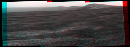
We can see the deepness below the "horizon" toward Cape Tribulation.
We can see the deepness below the "horizon" toward Cape Tribulation.
Here is the Colourized version of the
Pancam L2 view on Sol 2671.
jan van driel
Click to view attachment
Pancam L2 view on Sol 2671.
jan van driel
Click to view attachment
QUOTE (fredk @ Jul 31 2011, 02:35 AM)
Well, if you weren't sure what was Solander, this should clear it all up.
Was Tribulation visible from Victoria? (In case we climb up there, I want to know whether we'll see Victoria again
 )
)
QUOTE (Ant103 @ Jul 31 2011, 02:03 AM)
(internet through 3G network, in the Alps, it can be a little bit random).
We'll wait you'll be back and I hope you'll be able at least to "see" the final approach/arrival. I spent 8 days around La Meije last month with NO network available at all...
I've added a new version of Opportunity's journey to Endeavour Crater on Youtube covering sols 2553-2671
Too big to host here. Interesting to watch the scenery change.
Enjoy
Too big to host here. Interesting to watch the scenery change.
Enjoy
That's Awesome Astro0. Watched it more then a few times. From what I can see. Cape York has surprised us all and is actually below the Craters Edge and is probably harder material that did not get blown out from the impact that took place. I just want to get to the edge of the crater and see what Cape York really is and it now looks like we are going to have to drive down into the crater to investigate it instead of climbing a hill? From what I can see the angle of the drop into Endurance is not much. Thanks to all the image experts here.
It's not a surprise; we've known for ages now that CY is on the inner slope of Endeavour, the only question has been how high it rose above the surface, really. We'll see soon!
QUOTE (algorimancer @ Jul 31 2011, 02:01 AM)
Is that a cliff or crater rim
I think a crater and a sharp ridge. Check out the identification here.QUOTE (climber @ Jul 31 2011, 12:23 PM)
Was Tribulation visible from Victoria?
I think we could only see the north rim "twin peaks" and the far rim (east rim) peak - the one with the "cyclops" crater. So we may have to wait till we complete half our circumnavigation of Endeavour and climb that far rim peak to see Victoria again! 
QUOTE (Astro0 @ Jul 31 2011, 04:31 AM)
I've added a new version of Opportunity's journey to Endeavour Crater on Youtube covering sols 2553-2671
Too big to host here. Interesting to watch the scenery change.
Enjoy
Too big to host here. Interesting to watch the scenery change.
Enjoy
Excellent work. Love it.
As you might know, Paolo Belutta (rover planner) has been creating a "Endeavour Movie" -- we take a low-res navcam after each and every drive in the direction of Endeavour, and he's going to put them all a movie-like form, much like your video. I think there's going to be some extra goodies in there, but I haven't asked him. It'll prove to be a beauty.
-m
QUOTE (Stu @ Jul 31 2011, 09:39 AM)
Portrait of the Tribulation Range...
Those dark areas on the left suggest the spherules might go part way up the hill.
QUOTE (marsophile @ Jul 31 2011, 02:07 PM)
Those dark areas on the left suggest the spherules might go part way up the hill.
It will be interesting to see if the highest point which hematite spherule-containing sediments reached on the rim before they began eroding away can be determined.
wonderful. Just want to drive up Cape Trib and make a 370 degree super hirise panorama ...
Looks like a smoggy day in the Endeavour Basin tosol
Localised dust event 
QUOTE (MoreInput @ Jul 31 2011, 08:20 PM)
drive up Cape Trib and make a 370 degree super hirise panorama
And you know Oppy will give 110% as she does that!
QUOTE (MoreInput @ Jul 31 2011, 04:20 PM)
wonderful. Just want to drive up Cape Trib and make a 370 degree super hirise panorama ...
At 370 degrees, it will be a super-pan!

QUOTE (centsworth_II @ Jul 31 2011, 11:34 AM)
I...the highest point which hematite spherule-containing sediments reached on the rim ...
Curiously, the dark area boundary does not appear to be an equipotential line.
Later landslides would mess up that line anyway.
Phil
Phil
QUOTE (Matt Lenda @ Aug 1 2011, 03:52 AM)
As you might know, Paolo Belutta (rover planner) has been creating a "Endeavour Movie" -- we take a low-res navcam after each and every drive...
Thanks Matt.
Yep, I knew that Paolo had arranged for that sequence (#1994 was it?!) to be taken.
I think that more than a few of us are looking forward to seeing it completed and I bet that there might be one or two of us that will try to beat him to it of course, in our usual friendly UMSF way
Hey, I would like to climb there... fantastic, Ustrax!!!
Reiterating the proverb that hindsight is 20/20: a pronounced hint that Cape York's elevation profile was, shall we say subdued, lay in James' "Ripple Map". Note the the more pronounced topo features (the crater north of CY and Cape Trib to the south) produce an increase in dune coverage / magnitude down mean-wind of themselves, while such a feature is lacking with CY.
Wish I'd though of that sooner!
-- Pertinax
Wish I'd though of that sooner!
-- Pertinax
Music to my ears:
From Scott's twitter account: "Looks like we'll pull up at Spirit Point at Cape York (our chosen landfall point at Endeavour Crater) on Friday's (weekend) drive!"
Maybe we are there yet, soon. Maybe...
From Scott's twitter account: "Looks like we'll pull up at Spirit Point at Cape York (our chosen landfall point at Endeavour Crater) on Friday's (weekend) drive!"
Maybe we are there yet, soon. Maybe...
QUOTE (brellis @ Jul 31 2011, 12:45 PM)
Looks like a smoggy day in the Endeavour Basin tosol
Yeah, Tau is way up...
Are you able to provide numbers, Matt? The latest update says we had tau = 1.01 on 2668, but the latest (2671) pancams do look hazier than 2668.
QUOTE (fredk @ Aug 1 2011, 12:03 PM)
Are you able to provide numbers, Matt? The latest update says we had tau = 1.01 on 2668, but the latest (2671) pancams do look hazier than 2668.
Ehhhhhhhhh.... 1.1? I don't know anything but that it's up from Friday's planning.
It's been pretty noisy.
Yeah, 1.11 the last two sols, compared to bouncing between 0.9 and 1 most of last week. It's been quite variable, mostly between 0.8 and 1.1 lately. Within 3-6 weeks the variability should decline and a slow and steady drop should commence. And eventually, some of the residual opacity of 0.4-0.5 will be high-altitude clouds that don't impact viz.
Also, a little dust confined to the boundary layer (from nearby lifting, say) can be as bad for viz as a lot of dust distributed through the atmosphere.
Also, a little dust confined to the boundary layer (from nearby lifting, say) can be as bad for viz as a lot of dust distributed through the atmosphere.
Had a play about with a couple of the MIs that are available now...
Click to view attachment
...and I couldn't help thinking of the contrast...
Click to view attachment
Click to view attachment
...and I couldn't help thinking of the contrast...
Click to view attachment
QUOTE (Deimos @ Aug 1 2011, 04:25 PM)
Yeah, 1.11 the last two sols, compared to bouncing between 0.9 and 1 most of last week. It's been quite variable, mostly between 0.8 and 1.1 lately. [...] Also, a little dust confined to the boundary layer (from nearby lifting, say) can be as bad for viz as a lot of dust distributed through the atmosphere.
Thank you Deimos. Would an assumption that most of the current variability in tau is mostly related to variation within the BL be fair? I've been thinking about that recently and your post opened the door to ask!
QUOTE
Within 3-6 weeks the variability should decline and a slow and steady drop should commence. And eventually, some of the residual opacity of 0.4-0.5 will be high-altitude clouds that don't impact viz.
Would the time period spent integrating the MB at Cape York be one during which cloud obs would have a decent chance for being fruitful?
Thank you again for your time,
Pertinax
@Stu : Very nice comparison of different scale of size !
Where is Oppy looking at ? Navcam of Sol 2670
http://qt.exploratorium.edu/mars/opportuni...UIP1977L0M1.JPG
http://qt.exploratorium.edu/mars/opportuni...UIP1977L0M1.JPG
South. That's a bit of Tribulation on the left.
Cape Trib the last three sols.
Stitched together a few HiRISE zoom-ins and dropped virtual Oppys onto them to show how big the features and landmarks up ahead are compared to our gal...
http://roadtoendeavour.files.wordpress.com...t-plus-oppy.jpg
Note: the "route" is purely for fun, not suggesting that is the route Oppy will take.
http://roadtoendeavour.files.wordpress.com...t-plus-oppy.jpg
Note: the "route" is purely for fun, not suggesting that is the route Oppy will take.
Will Oppy make so many turns and curves? Or just drive along a "We brake for nobody"-line right to Spirit Point ? We will see, soon
QUOTE (Pertinax @ Aug 2 2011, 02:40 AM)
Would an assumption that most of the current variability in tau is mostly related to variation within the BL be fair?
Could go either way in principle--I'd favor the BL at Gusev. The images suggest that is true. Despite that, the dust still increases with height (the principal source is a storm track thousands of km away). If we had tau=1.15 (the new value) well-mixed, the far rim would be even murkier. For dust perfectly mixed through the whole atmosphere, the opacity across the crater would be about twice the measured (zenith) value on any given sol. I wonder if visibility might get worse before it gets better, even as the dust settles. We'll be testing that, of course.
QUOTE (Pertinax @ Aug 2 2011, 02:40 AM)
Would the time period spent integrating the MB at Cape York be one during which cloud obs would have a decent chance for being fruitful?
Yes. It has been the norm to get more cloud images & movies during the aphelion months.
Opportunity drove some 120 meters today; almost straight down toward Botany Bay. There should be HOAV here.
Maybe MER team shold consider taking some time to snap at least one quick 180 degrees L257 panorama of Endeavour. Just one line of images covering horizon.
Maybe MER team shold consider taking some time to snap at least one quick 180 degrees L257 panorama of Endeavour. Just one line of images covering horizon.

I feel the same way about that Image Fred K.
Oppy has moved from the Flat Midwest Region and is now entering The Rocky Mountains and Grand Canyon area.
This is going to get real scenic, interesting and what's new around the next corner.
I see us spending a lot of time at Cape York area and then driving south to climb a mountain.
Oppy has moved from the Flat Midwest Region and is now entering The Rocky Mountains and Grand Canyon area.
This is going to get real scenic, interesting and what's new around the next corner.
I see us spending a lot of time at Cape York area and then driving south to climb a mountain.
This is a "lo-fi" version of our main content. To view the full version with more information, formatting and images, please click here.