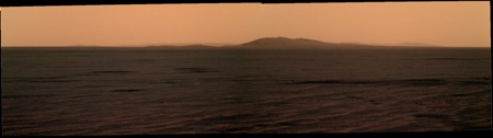
Just to show how high our current local horizon is, here's a trip back in time to the view on Sol 2336... just look how much higher above the horizon that crater on the farside hills was then...
Click to view attachment
Full Version: Post Conjunction: Santa Maria to Cape York
Pages: 1, 2, 3, 4, 5, 6, 7, 8, 9, 10, 11, 12, 13, 14, 15, 16, 17, 18, 19, 20, 21, 22, 23, 24, 25, 26, 27, 28, 29, 30, 31, 32
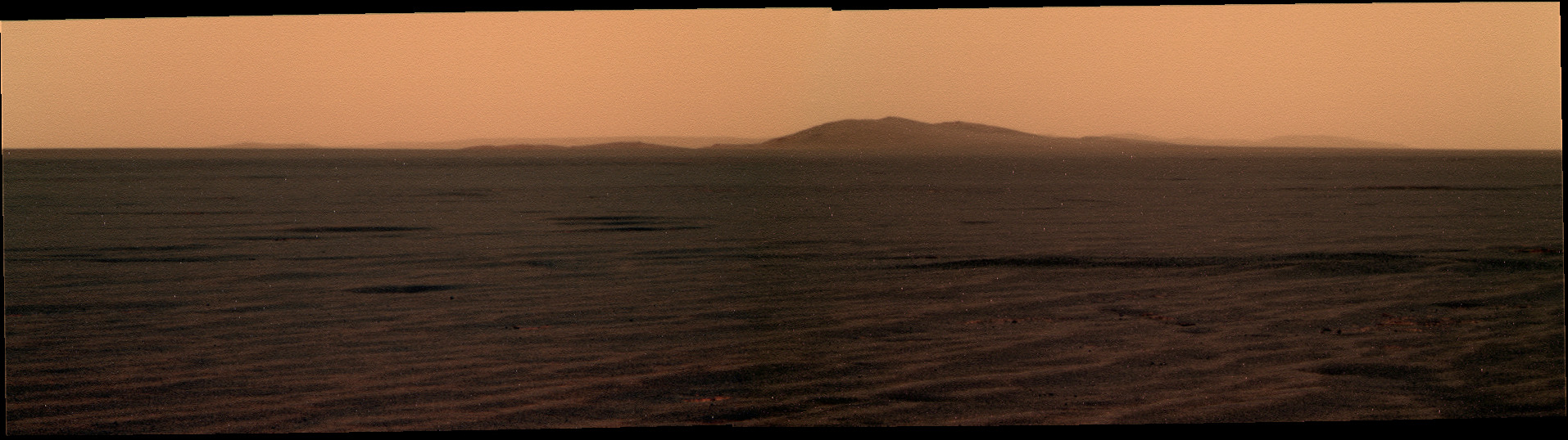
Here's the latest view, from 2627, of the "Cape approach" crater sitting on the horizon in front of us. Average of L2/R2 frames, 2x scaled, and contrast tweaked a bit:
Click to view attachment
Click to view attachment
Thanks for that reminder Stu. No point in looking for Cape York until all that's reappeared, else it would have been visible back then. Cape approach crater looks like a nice place for a picnic.
Yeah, I think you're right Nigel. Still, it might surprise us yet...
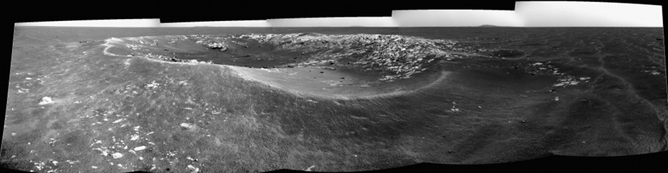
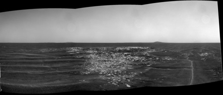
In the meantime, continuing our series of "I know it's wrong in so many ways, scientically, but it looks pretty..." portraits of Endeavour Crater...
Click to view attachment
In the meantime, continuing our series of "I know it's wrong in so many ways, scientically, but it looks pretty..." portraits of Endeavour Crater...
Click to view attachment
You have to wake up early to get that shot, eh Stu? 
Absolutely. It's a three cup of coffee shot, to be sure 
Here is a view from Google Mars with a three times exaggerated profile. If the profile is real, we will ascend just the next 1000 meters and we are at the "top" of the landscape which blocks out our view of Endeavour. I hope that we have here then a heck of a view, even if Cape York will be still invisible.
The profile may be real but you / we should also consider that the HiRISE background is somehow displaced in relation to the background embedded on GE.
According to that profile we would not be seeing the approach crater now. Of course the feature we're seeing in silhouette could be something on the closer bedrock outcrop at the top of your profile, aligned by chance with the crater, but I doubt it. I'm with fredk for now.
According to Google Mars we are now at a heigth of -4756 feet below mars sea (? :-) ) level, and in one kilometer we are at -4733, thats 23 feet or 7 meters.
The measurements of Emilys MOLA data vary between -1462 and -1468 (meters) in this region. But I know it not good to over-interpret the google data here ... it just was intended to give a hint.
The measurements of Emilys MOLA data vary between -1462 and -1468 (meters) in this region. But I know it not good to over-interpret the google data here ... it just was intended to give a hint.
I was wondering how many craters Oppy has been to an imaged??? I should go count them all? LOL
Ones I can name off the top of my head in rough chronological order...
Eagle
Fram
Endurance
Vostok (highly erroded)
James Caird
Viking
Voyager
Erebus
Beagle
Victoria
Concepcion
Santa Maria
And the recent swath of early manned spaceflight ones.
Eagle
Fram
Endurance
Vostok (highly erroded)
James Caird
Viking
Voyager
Erebus
Beagle
Victoria
Concepcion
Santa Maria
And the recent swath of early manned spaceflight ones.
Sputnik
Surely a new history chapter shall be gleaned from Oppy's astonishing crater survey... Ooh! here's another one ...
Now, that was a quick visit to this "crater cluster" because it is already some 70m behind on the rear mirror.
Images from the current site, on sol 2628, here: http://qt.exploratorium.edu/mars/opportuni...cam/2011-06-16/
Images from the current site, on sol 2628, here: http://qt.exploratorium.edu/mars/opportuni...cam/2011-06-16/
Rear mirror? We are driving backwards since a long time ... 
She's a MER with a Mission! Onwards, ever onwards...
The US has had a lot of significant space events on July 4, 16, and 20. At the current rate of progress, I wouldn't be surprised to see another event added to the list for one of those dates this year.
At the risk that this has been discussed already, consider again the map from a previous post by fredk (post is at http://www.unmannedspaceflight.com/index.p...p;#entry173430)
Click to view attachment
... he points out possibilities for the distant feature "B," very likely the "Cape Approach Crater":
Click to view attachment
...with a more recent view of that distant whale-tail feature here: http://qt.exploratorium.edu/mars/opportuni...00P2442L2M1.JPG
If you follow the top line in the above map from A to B, then extend it beyond B, it will nearly take you the "Whale Tail Peaks," the two highest points of Cape York in my estimation:
Click to view attachment
But the southern of those two peaks looks like it should be noticeably higher, judging by the wider parallax spread displayed in the red channel on this image: http://www.marspages.eu/media/archive4/mer...CapeYork_3D.jpg
...and the two "peaks" on feature "B" look pretty level on recent images. Darn! Maybe it's not it. But wait. They look level until you zoom way in on the pixels, as in the next and final image.
Click to view attachment
The hill on the right has a few more darker pixels... Hmmm. Now I think I'm losing it, suffering from seeing what I want to see. This is awful. Come on, Oppy!
Click to view attachment
... he points out possibilities for the distant feature "B," very likely the "Cape Approach Crater":
Click to view attachment
...with a more recent view of that distant whale-tail feature here: http://qt.exploratorium.edu/mars/opportuni...00P2442L2M1.JPG
If you follow the top line in the above map from A to B, then extend it beyond B, it will nearly take you the "Whale Tail Peaks," the two highest points of Cape York in my estimation:
Click to view attachment
But the southern of those two peaks looks like it should be noticeably higher, judging by the wider parallax spread displayed in the red channel on this image: http://www.marspages.eu/media/archive4/mer...CapeYork_3D.jpg
...and the two "peaks" on feature "B" look pretty level on recent images. Darn! Maybe it's not it. But wait. They look level until you zoom way in on the pixels, as in the next and final image.
Click to view attachment
The hill on the right has a few more darker pixels... Hmmm. Now I think I'm losing it, suffering from seeing what I want to see. This is awful. Come on, Oppy!
Mmm, interesting.
But here's another approach on this topic. Taking the absolute headings of 1) the crater on the far side 2) feature "B" and 3) the "Whale Tail Peaks" as measured on the HiRISE and CTX pictures and translating them to the latest pancam mosaic here's what I get.
Click to view attachment
Click to view attachment
I would love to have said "LAND HO", but it's still too early. The bumps are on the heading of feature "B" / "Cape Approach Crater".
Solar panels cleaned! Power production up to 528.
Thanks for those headings, Tesheiner. You've convinced me! 
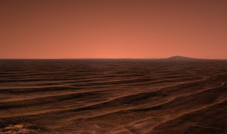
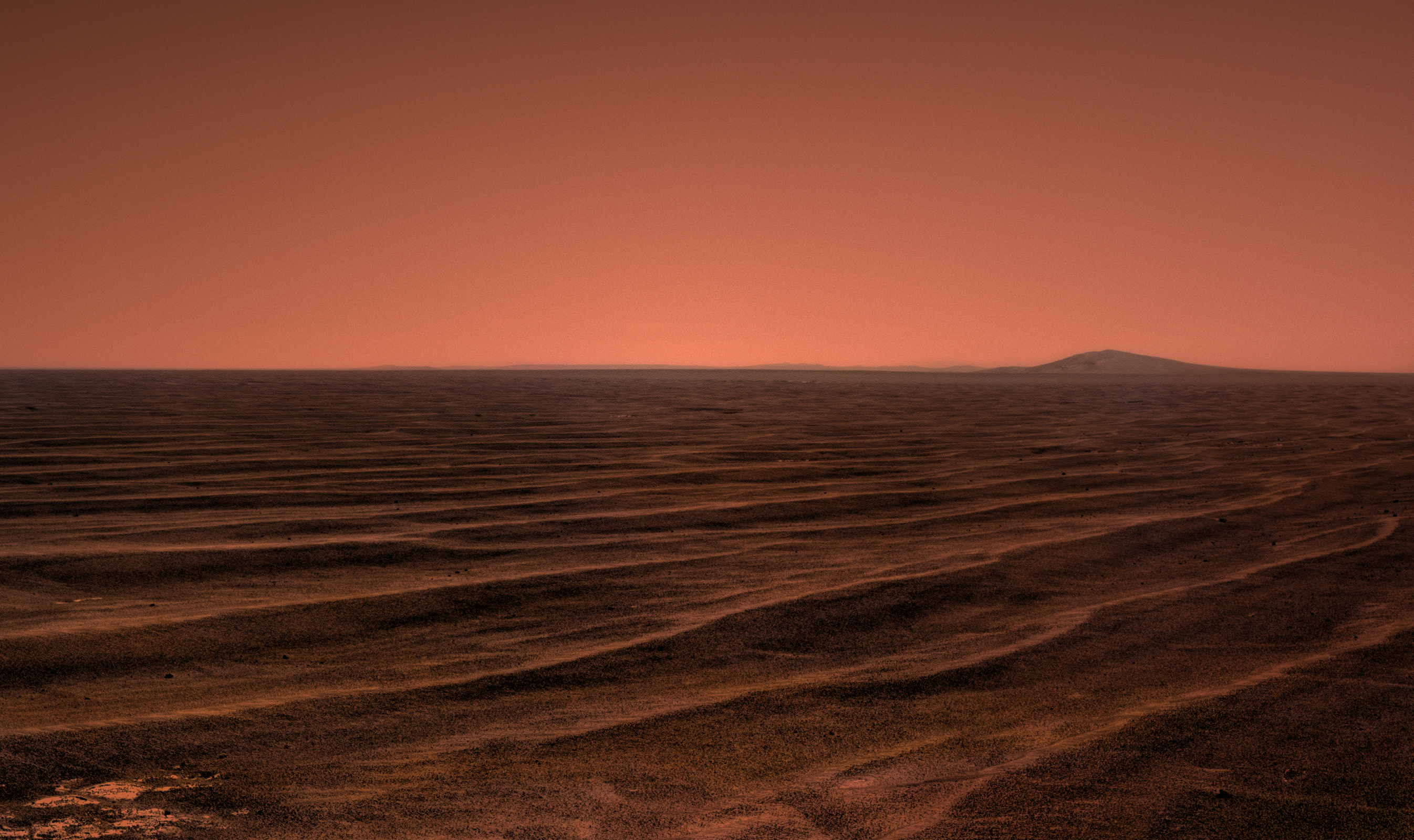
I've been noticing interesting features in the shape of the horizon as we approach Endeavour. Here are a couple of recent examples:
Click to view attachment
Click to view attachment
(Both are 3x vertical stretched.) It would be really cool to see a full (or half) horizon pan showing exactly what the eastern horizon is doing. The problem is that the result would be very sensitive to how you project and splice the images together - you could easily introduce similar but fictitious features. Way beyond my abilities, anyway.
Basically, I interpret these features as evidence that there's something really really big looming just to our east!
I had the impression from some of the earlier stretched horizon shots (going back even before Santa Maria) that there was a bulge on the horizon about where Antares is (that's the very subdued crater NE of Cape York). Maybe that is what is shaping the current horizon. Regarding Fred's comment about splicing images together, yes, that can introduce bad artifacts, but a more distant shot could provide the control necessary to sort it out. I would be stretching the control image and these new ones an equal amount before making the mosaic, not after. (Can't do it now, I'm still away from the office)
Phil
Phil
...and Opportunity has reached the 19 mile mark! So put on some Steely Dan and raise your glass of Cuervo Gold!
Hey Nineteen
No we got nothing in common
No we can't talk at all
Please take me along
When you slide on down
The Cuervo Gold
The fine Colombian
Make tonight a wonderful thing
We can't dance together
No we can't talk at all
Hey Nineteen
No we got nothing in common
No we can't talk at all
Please take me along
When you slide on down
The Cuervo Gold
The fine Colombian
Make tonight a wonderful thing
We can't dance together
No we can't talk at all
Thanks Tesheiner, you've convinced me too that it's just the "Approach Crater."
After the 2630 drive, we're close to another ~15 metre crater. Here it is in the drive direction pancam view (with the "cape approach" crater about 1.5 km away on the horizon):
http://qt.exploratorium.edu/mars/opportuni...2M1.JPG?sol2630
http://qt.exploratorium.edu/mars/opportuni...2M1.JPG?sol2630
It's apparent that 'approach crater' is sometimes silhouetted against the sky (as now) and sometimes against the terrain on the far side of Endeavour, as our vantage point rises and falls by a matter of centimetres over the subtle undulations of Meridiani Planum. It's my impression from the most recent images that its profile is more subdued when our vantage point is lower. I think this means that it is located just beyond the topographic rise (or change of curvature) that forms the near horizon. That would augur well for a HOAV from 'approach crater'.
My thoughts exactly. I've gotten the impression on our long drive across Meridiani that large expanses of exposed bedrock are higher than the darker, dust covered regions in between. There's a large expanse of bedrock roughly half a km before (NW of) Cape Approach crater. So our local horizon probably corresponds to the bedrock, with CA crater just beyond.
We're now getting into one of the large darker regions, so I'd expect we may drop even more before the final climb up to the bedrock region.
We're now getting into one of the large darker regions, so I'd expect we may drop even more before the final climb up to the bedrock region.
I think we're still a good klick away from seeing the highest points of Cape York rise above the horizon, but I'd love to be proved wrong. And hope I am.
Meanwhile, I've spotted something interesting up ahead - well, a little bit off the track, up ahead (and if someone else has found it already, forgive me, I haven't gone back to the start of this thread to check). There's what looks, to my untrained eye, to be a decent-sized outcrop available for study before we get to Approach Crater, shown here with a fake Oppy dropped beside it...
Click to view attachment
Might just be a light-and-dark illusion, but it caught my eye, that's all I'm saying. Lots more pics (and speculation!) in my blog post, if anyone wants a look:
http://roadtoendeavour.wordpress.com/2011/06/19/vroooom
Good eye, Stu. That is quite a striking feature. But I'd point out that, based on the craters and dunes in the area, the light's coming from the west in that view. So the feature is a "valley" region, rather than a ridge, if we're seeing topography rather than albedo. That area is crisscrossed by lots of straightish "valleys"/"anatolia" features/faults. Maybe your feature is just a localized piece of one of those features. It certainly would be cool to see it up close, though.
Oh..... b****r. I was sure I was seeing a ridge in 3D. I was even thinking the shadows of features "on the top" lined up with features "on the ground". Just goes to show how your eyes can be fooled. Oh well, it was a nice idea for the six hours it lasted! Thanks for the correction. I'll amend my blog accordingly.
Thanks for the correction. I'll amend my blog accordingly.
Hello there,
It's been a looooong time, isn't it ?
I decided to stop image processing because of my diploma preparation. A lot of stuff to do, so I took the option to keep all my attention on it. Now, I get my 5th year diploma (actually, a Master of Design). I got it with success and a mention. One the most wonderfull moment in my life.
Anyway, I think I will have a great time to have a hand on the last pics from Oppy, which looks amazing, with Cape York clearly visible now.
See you very soon.
It's been a looooong time, isn't it ?
I decided to stop image processing because of my diploma preparation. A lot of stuff to do, so I took the option to keep all my attention on it. Now, I get my 5th year diploma (actually, a Master of Design). I got it with success and a mention. One the most wonderfull moment in my life.
Anyway, I think I will have a great time to have a hand on the last pics from Oppy, which looks amazing, with Cape York clearly visible now
.See you very soon.
Hi Ant103!
Welcome back and congratulations to your diploma! Can't wait to view your newest Panoramas, soon!
Welcome back and congratulations to your diploma! Can't wait to view your newest Panoramas, soon!
Congratuations, and welcome back, Ant!!!
THERE you are, Ant!! Congratulations on your success, now get cracking on those images, we've all missed your magnificent vistas!!!
Félicitations Ant! - We've always known that you are a Master of Design.
Thank you so much guys . This give me much more envy to do these stuffs !
And here we go, with 3 pans :
Sol 2586, Freedom 7 crater (if I don't make mistake).
Sol 2621, with a good view on the Western Hills :

There are no multi-filters pictures so I decided to do this colorization :
. This give me much more envy to do these stuffs !And here we go, with 3 pans :
Sol 2586, Freedom 7 crater (if I don't make mistake).

Sol 2621, with a good view on the Western Hills :


There are no multi-filters pictures so I decided to do this colorization :
Damn, Ant, talk about making a comeback!!! 

Beautiful, as always, and congratulations again on finishing your degree. That's one of the top 5 best feelings in the world!
Beautiful, as always, and congratulations again on finishing your degree. That's one of the top 5 best feelings in the world!
Alright, no-one else is going to ask, even if you're all wondering...
...and the other four are, Nick..?
...and the other four are, Nick..?
Click me:
muoahahaha!
Congratulastions on your degree Ant103 and also fantastic work.
Ouahaha Nick !!! I love the laugh of Bender too !
An other pan, of Sol 2569 :
These hills are mesmerizing ! What is the altitude of Cape Tribulation ?
An other pan, of Sol 2569 :
These hills are mesmerizing ! What is the altitude of Cape Tribulation ?
QUOTE (Ant103 @ Jun 19 2011, 06:27 PM) 
I got it with success and a mention. One the most wonderfull moment in my life.
Bravo Damien pour votre diplôme !
Hi Ant, welcome back!
On another topic and while preparing the current route map update, the one for sol 2633, I said to myself: "Only 80m?!?"
But then I remembered the time when the surface ops started, the mission successful requirements and expectations during those early days... and wondered which would be the reaction after such a drive right after leaving Eagle.
When is the next drive planned?...oops, just noted the post a couple minutes earlier
QUOTE (NW71 @ Jun 19 2011, 11:41 AM)
...thanks to the work of Pythagoras (and the 100m cubes supplied by Tesh) ...
I used the same method to find that Oppy is 2.25 km from Spirit Point (actually a point east of the crater). I think I did my math right.
Oppy is now closer to 'Spirit Point' than Spirit was to the Columbia Hills when it landed.
Oh, it is so close I can almost taste it.
Are we there yet?

Oh, congratulations Ant, and welcome back.

Thank you guys for all your messages
Yep Tesheiner, that's what amazed me sometimes. I remember the times when we had a look beyond the rim of Eagl Crater and see this "untouchable" Endurance crater. Those rims And now we are largely out of the landing ellipse, prepare to reach the biggest crater ever seen. Just wow !
Yep Tesheiner, that's what amazed me sometimes. I remember the times when we had a look beyond the rim of Eagl Crater and see this "untouchable" Endurance crater. Those rims And now we are largely out of the landing ellipse, prepare to reach the biggest crater ever seen. Just wow !
Short 16m autonav drive thisol (2634). I guess it's due to the lack of nav/pancam "post-drive" images from yesterday so better move a short distance in "safe-mode" than wait for another sol.
This is a "lo-fi" version of our main content. To view the full version with more information, formatting and images, please click here.