Full Version: Post Conjunction: Santa Maria to Cape York
Pages: 1, 2, 3, 4, 5, 6, 7, 8, 9, 10, 11, 12, 13, 14, 15, 16, 17, 18, 19, 20, 21, 22, 23, 24, 25, 26, 27, 28, 29, 30, 31, 32
FWIW, there's another drive planned for today and, actually, Opportunity should be on the move right now. Let's see what the next batch of images show to us; there are no pancams on today's plan but maybe tomorrow.
Do you know how far?
Not yet, but looking to the planned imaging sequences (see below) I think the plan includes a "mid-drive" navcam mosaic, probably of the little crater 90+ meters SE from the sol 2662 position, so I bet for a long 100+ meters drive.
02663::p0025::01::0::0::0::0::0::0::mer_b_sunfind_parms_left_eye_525_exp
02663::p0693::03::6::0::0::6::0::12::navcam_3x1_az_162_3_bpp <--- "post-drive" mosaic
02663::p1201::07::2::0::0::2::0::4::front_haz_penultimate_1bpp_pri17
02663::p1211::03::2::0::0::2::0::4::ultimate_front_haz_1_bpp_pri_15
02663::p1254::02::2::0::0::2::0::4::front_haz_fault_pri15_4bpp
02663::p1301::06::2::0::0::2::0::4::rear_haz_penultimate_1bpp_pri17
02663::p1312::07::2::0::0::2::0::4::rear_haz_ultimate_2_bpp_pri15
02663::p1354::01::2::0::0::2::0::4::rear_haz_fault_pri15_4bpp
02663::p1916::06::4::0::0::4::0::8::navcam_2x1_az_75_3_bpp <--- "mid-drive" mosaic?
02663::p2601::05::4::2::0::0::2::8::pancam_tau_L78R48
02663::p2627::02::36::0::0::0::0::36::pancam_sky_radiance_thumbs_L457R247
Click to view attachment
Why no pancams? I'd have thought they'd want as many as poss in the home run to CY.
Oh well, sure the navcams will be great!
Oh well, sure the navcams will be great!
Emily: "Wow, those triangular peaks to the south are really popping up too. Are they all part of Cape Tribulation? "
James: " They probably are the very nearest peaks of the Cape Trib range that point toward Cape York. "
If you check out Tesheiner's map in post 976 above, you can see that Solander Point (the smaller hills north of Cape Tribulation) must be directly in line with the Cape, in front of it. The hills appearing to the left are the more distant ones, where the rim curves eastwards.
Phil
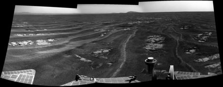
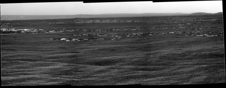
Cape York much more visible now even in the in the Navcams
http://qt.exploratorium.edu/mars/opportuni...00P0693R0M1.JPG
Phil, your right. I've changed my mind back again!
Here are the hills in question at pancam resolution.
http://qt.exploratorium.edu/mars/opportuni...00P2368L2M1.JPG
http://qt.exploratorium.edu/mars/opportuni...00P0693R0M1.JPG
Phil, your right. I've changed my mind back again!
Here are the hills in question at pancam resolution.
http://qt.exploratorium.edu/mars/opportuni...00P2368L2M1.JPG
BTW, looks like the drive faulted out (Fault images taken (P1254 & P1354) and no turn in place) given the time the images were taken, I'm guessing it was at the end just before the turn for comm. Not sure how far the drive was as the site id was reset and no intermediate data is available yet.
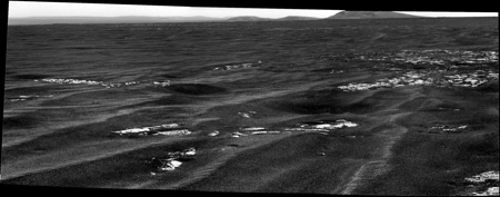
Here is a quick 5x Phil-o of Cape York from tosols navcam view
I wonder if that explains the azimuths of the new nav/pancams? Based on those views I thought at first that they intended to turn S/SE now. If that was it, then we might not get more pancams of the peak of CY we can see now.
Anyway, here's the best we can do now - this is the registered average (to reduce jpeg noise) of the new L/R navcan views of CY:
Click to view attachment
We're starting to resolve the profile of the top of CY...
Anyway, here's the best we can do now - this is the registered average (to reduce jpeg noise) of the new L/R navcan views of CY:
Click to view attachment
We're starting to resolve the profile of the top of CY...
To my mind it makes more sense to keep on this heading, and then drive along Cape York to the south end for morphological imaging along the way and to look for other potential outcrops of interest.
This is quite the new adventure! After three years of plains, a whole new mission.
Phil
This is quite the new adventure! After three years of plains, a whole new mission.
Phil
QUOTE (Stu @ Jul 22 2011, 04:21 AM) 
Why no pancams?
Data volume, power budget, time constraints....all of the above...who knows...we'll probably get them tomorrow.

QUOTE (djellison @ Jul 22 2011, 03:29 PM)
all of the above...who knows...
Yep. Not a complaint, just a with-raised-eyebrow "Hmmm?"
I'll have to view those images on my phone, I guess; going to be at the seaside. That's pretty amazing in itself: sitting on a harbour wall, eating fish n chips, looking at new pictures of Mars on my phone. Unbelievable.
QUOTE (Sunspot @ Jul 22 2011, 07:41 AM)
It looks lighter than the peaks around Cape Tribulation.
In addition to what Tesheiner said, there's also lighting. These images are taken in the afternoon, with the sunlight coming from the west. We're looking from the west at the slope of CY facing west, so it should appear lighter for that reason. Tribulation is to the south, so we aren't seeing it as directly lit as CY.About the rim hills to the south, I agree with James's (final) position. I mentioned before that once we drop enough Solander should pop into view. It may have done that already - here's my tentative ID:
Click to view attachment
Phil: yeah, I hope we do a CY survey too!

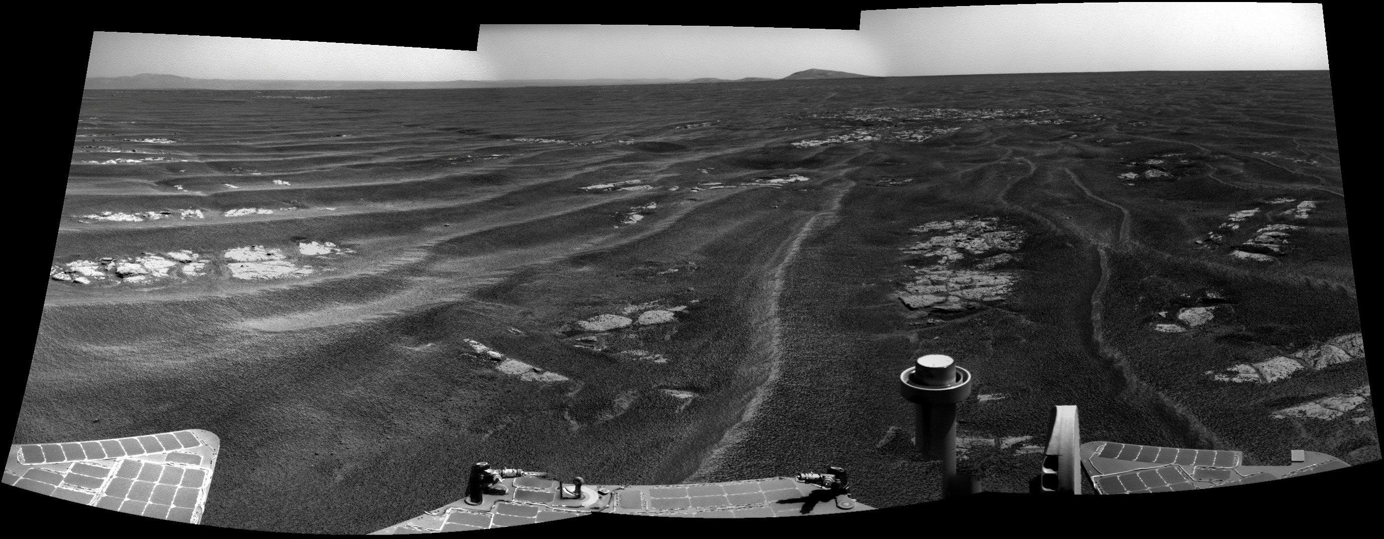
Here's the navcam mosaic.
Click to view attachment
Same for me, starting tomorrow, but with a notebook instead of a phone.
I was thinking on a direct route but, yes, a survey definitely makes a lot of sense.
Click to view attachment
QUOTE (Stu @ Jul 22 2011, 04:45 PM)
I'll have to view those images on my phone, I guess; going to be at the seaside. That's pretty amazing in itself: sitting on a harbour wall, eating fish n chips, looking at new pictures of Mars on my phone. Unbelievable.
Same for me, starting tomorrow, but with a notebook instead of a phone.
QUOTE (fredk @ Jul 22 2011, 04:51 PM)
Phil: yeah, I hope we do a CY survey too!
I was thinking on a direct route but, yes, a survey definitely makes a lot of sense.
Navcam of tosol pan :
What's totally blew me is that I was stitching a panoramic who was taken about 5h before on Mars.
Mars, so close and so distant in the same time.
About the pancams, we can wait. It was a long LONG journey. So, one day or more
What's totally blew me is that I was stitching a panoramic who was taken about 5h before on Mars.
Mars, so close and so distant in the same time.
About the pancams, we can wait. It was a long LONG journey. So, one day or more
RE the pancams. They were actually taken, just not listed in the PDT beforehand. The one pancam image we have is from it (seq P2368) the other two are on the ground so we should get them later today.
More data now in - drive was about 105m
More data now in - drive was about 105m
Yup. First 20m ESE to take some shots of Mariner 9 from the SE corner and also to have a look at that rock pile (incidentally, named Mariner 10), and then the remaining 85 meters or so on a SE heading.
Can't wait for the LAND HO! 360 degree full pancam panorama viewing all inside of Endeavour and Cape York ...
QUOTE (Phil Stooke @ Jul 22 2011, 04:19 PM)
This is quite the new adventure! After three years of plains...
...and 20 kms!
Following Scott's blog, when I realized last week that we're already at Victoria, I thought:"that was fast".
This has been a very large traverse.

Here's a quick partial pan of three pancam images from today
(since I had PTGui open on another project)
(since I had PTGui open on another project)
You were quick ElkGrovDan 
Lots of details on the hills. Quite amazing.
Lots of details on the hills. Quite amazing.
Also, from looking at the Google Mars of the approach to Cape York, the familiar North/South ripples or dunes that we have been driving across for so long look like they are about to dissapear.
Yep, we're coming up to terrain that looks "smudged" from orbit.
Amazing detail in Tribulation now. Here's an L2/R2 average, with (only!) 2x vertical stretch:
Click to view attachment
And the ID of Solander looks pretty solid now:
Click to view attachment
Amazing detail in Tribulation now. Here's an L2/R2 average, with (only!) 2x vertical stretch:
Click to view attachment
And the ID of Solander looks pretty solid now:
Click to view attachment
No more dunes/ripples...for now at least
http://qt.exploratorium.edu/mars/opportuni...PTP0683L0M1.JPG
http://qt.exploratorium.edu/mars/opportuni...PTP0683L0M1.JPG
Very subtle ripples only... fascinating. The Bernoulli principle of faster airflow operating on the rim of Endeavour, perhaps...
It looks to me like a 140 metre or so drive towards Spirit Point on 2664. Here's my location, with a couple of craters identified:
Click to view attachment
Click to view attachment
The lack of N-S ripples really throws you off - but then there are plenty of features on the horizon now to help get your bearings!
Click to view attachment
Click to view attachment
The lack of N-S ripples really throws you off - but then there are plenty of features on the horizon now to help get your bearings!
That's about where I put us too. The rock outcrops confirm it when you look at the full resolution HiRISE.
Phil
Phil
I hope Oppy's solar panels do also know the Bernoulli principle. I hope, that there will be some gust at the crater rim to clean up the solar cells. Oppy deserves it!
I think the small crater at Spirit Point will be their target. There are some large boulders on its rim, that might allow them to sample the rocks that make up Endeavour's Rim
holy smokes!
this is getting very exciting!
I cant wait to look into that big crater!
(way to go JPL!)
this is getting very exciting!
I cant wait to look into that big crater!
(way to go JPL!)
I'm no expert, but I expect the rocks of Endeavour's rim are basaltic. The hydrated sulfates and clays that are the primary objectives of study are not going to be found in those rocks (ejecta from the Spirit Point crater), I expect. Although Spirit got sick and tired of basalt, it would be a real novelty for Opportunity!
No, CRISM data say that's exactly where the clays will be found, and the hydrated sulfates are in the plains at Botany Bay.
Phil
Phil
But are the clays more likely to be found in weathered rim or in "freshly" ejected rocks from craters on the rim? In other words were the clays formed after the creation of Endeavour crater or was Endeavour crater created in a surface which contained clay before the crater's formation?
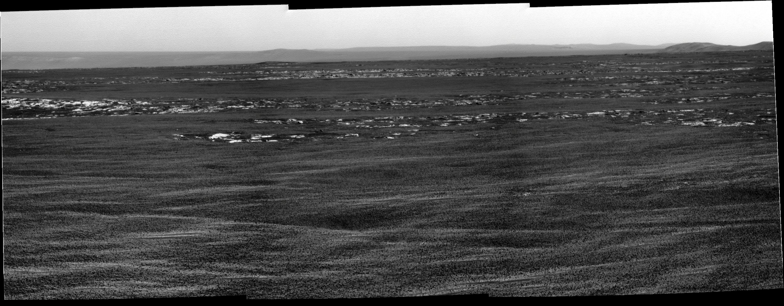
New details with every sol - this is like being a kid in a candy store! The south rim is starting to show some structure now - here's an L2/R2 average from sol 2664 to reduce noise, followed by a stretch:
Click to view attachment
And my attempt at identifying features:
Click to view attachment
The white curve marks a boundary: lighter above, darker below. I'm not sure exactly what that corresponds to on the orbital view, but we may be starting to see the great dark dunefield in the southern part of Endeavour...
Click to view attachment
And my attempt at identifying features:
Click to view attachment
The white curve marks a boundary: lighter above, darker below. I'm not sure exactly what that corresponds to on the orbital view, but we may be starting to see the great dark dunefield in the southern part of Endeavour...
I think that we are still on the mostly flat plains and we cannot look downwards, yet.
But if we are reaching the cobble identified by fredk at the near horizon we are at the real crater border, at which the slope really begins, and we see really much more.
http://www.unmannedspaceflight.com/index.p...st&id=24947
The view will change dramatically the next days.
But if we are reaching the cobble identified by fredk at the near horizon we are at the real crater border, at which the slope really begins, and we see really much more.
http://www.unmannedspaceflight.com/index.p...st&id=24947
The view will change dramatically the next days.
QUOTE (centsworth_II @ Jul 23 2011, 07:26 PM)
...... were the clays formed after the creation of Endeavour crater or was Endeavour crater created in a surface which contained clay before the crater's formation?
For my money the clays were formed pre impact and preserved within the upturned/overturned rim rock, protected from the subsequent acidic waters. Subsequently some deposits have weathered out or, seemingly in the case of CY, displaced as impact ejects.
QUOTE (serpens @ Jul 23 2011, 06:02 PM)
For my money the clays were formed pre impact.... Subsequently some deposits have weathered out or, seemingly in the case of CY, displaced as impact ejects.
That sounds good to me. Of course only a fraction of the pre-impact terrain would have been clays, hopefully a large fraction. It will be interesting to see what that Spirit Point crater's ejecta looks like.
Sol 2664 drive direction :
Oh, wait! I think I left my wallet on the rim at Victoria Crater - we need to turn around and go get it!
You'll have to walk back!
Phil
Phil
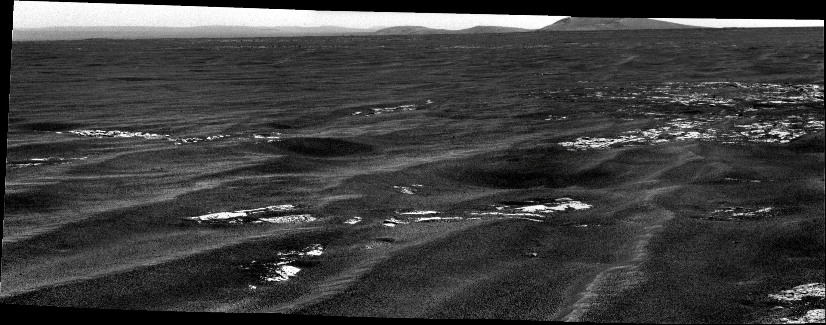
Our best view of CY yet, average of L0/R0 navcams from 2664. 3x vertical and contrast stretch:
Click to view attachment
Also some serious detail emerging on the far rim! Pancams would be fantastic, though for now it looks like the pancams will be pointing SE instead of E...
Click to view attachment
Also some serious detail emerging on the far rim! Pancams would be fantastic, though for now it looks like the pancams will be pointing SE instead of E...
Then you'll want to keep an eye out for P2371 (pancam_Endeavour_rim_2x1_L257). Thumbnails are down. Lossless full frames are a bit buried in the d/l queue, but if they get down before we get too much closer, they'll have a nice view of that spot.
just...unbelievable...u-n-b-e-l-ie-v-a-b-l-e...
3D view of Ant's panorama... zoom in, go to the far right, and see the near horizon line cutting across the hills... just wonderful...
http://twitpic.com/5vcnlw/full
http://twitpic.com/5vcnlw/full
I think the mods may need to reintroduce the swear jar....
*CLINK* *CLINK* *CLINK* This is getting good!
*CLINK* *CLINK* *CLINK* This is getting good!
I was beginning to wonder when the view would become incredible. I think we're there.

QUOTE (Deimos @ Jul 24 2011, 02:02 PM)
... keep an eye out for P2371 ...
I can see that the thumbnails are down, but I can't yet display them with a query.
Similar to Fredk's version but even more stretchy (Phil-o-sized).
Some nice details showing up. Would be interested to see if James or others would be brave enough to start identifying any features on Cape York
Click to view attachment
Some nice details showing up. Would be interested to see if James or others would be brave enough to start identifying any features on Cape York
Click to view attachment
QUOTE (Astro0 @ Jul 25 2011, 08:01 AM)
Would be interested to see if James or others would be brave enough to start identifying any features on Cape York
Maybe. I've actually sat down at my computer a couple of times thinking about doing some feature mapping but decided it would take more time than I had. Maybe tonight...
This is a "lo-fi" version of our main content. To view the full version with more information, formatting and images, please click here.