Inspiring images Ant103, thank you.
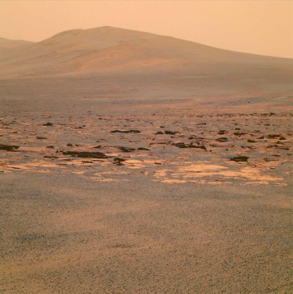
You own my desktop .. I'm on Mars!
Full Version: Post Conjunction: Santa Maria to Cape York
Pages: 1, 2, 3, 4, 5, 6, 7, 8, 9, 10, 11, 12, 13, 14, 15, 16, 17, 18, 19, 20, 21, 22, 23, 24, 25, 26, 27, 28, 29, 30, 31, 32
QUOTE (jvandriel @ Aug 8 2011, 12:32 AM) 
Here is the Pancam L2 Panoramic view on Sol 2679
in colour.
in colour.
But it's not color, is it. You've changed a greyscale image into what can best be described as a series of colors from the Spring Titan range. Without meaning to demean any effort in processing imagery - I'm really not sure what improvement they make.
QUOTE (djellison @ Aug 8 2011, 04:01 PM)
But it's not color, is it.
Those are not L2 images from sol2679. Its actually croped L257 color pan sol 2678.
QUOTE
02678 11:01:01 p2383.28. 1 8 8 8 8 8 8 pancam_Solander_Point_2x1_L257R2
If it were colorisation of drive direction pancams from sol2679 then it would be WOW.......
QUOTE (Astro0 @ Aug 7 2011, 01:29 AM)
Just to put Opportunity's journey across Meridiani Planum from Eagle Crater to Endeavour Crater in some kind of context to the vistas we are seeing now.
Here's an image showing Opportunity's path (in yellow) and that same path (in purple) [in reverse] marked out across Endeavour Crater.
Click to view attachment
Opportunity and all of us have travelled far!
EDIT: Of course, the purple path doesn't take into account the topography, terrain and certainly not the last 7.5+ years of trials and triumphs.
We can do that!

-Tim.
QUOTE (Toma B @ Aug 8 2011, 07:09 AM)
Those are not L2 images from sol2679. Its actually croped L257 color pan sol 2678.
He states himself it's just L2 he's used. It's a greyscale image. But for reasons I just don't understand, it's then very very heavily tinted orange. It's not color.
And it's like looking at a picture of Titan, not Mars. I don't understand the obsession with (or benefit of) colorizing a greyscale pan like that.
QUOTE (djellison @ Aug 8 2011, 04:22 PM)
I don't understand the obsession with (or benefit of) colorizing a greyscale pan like that.
I suspect it's artistic license, an entirely personal choice, which I support wholeheartedly. I find the tint evocative, and personally enjoy seeing these pictures.
Keep it up Toma !!
QUOTE (DFortes @ Aug 8 2011, 09:19 AM)
Keep it up Toma !!
It's not his picture I'm talking about.
I often find the colorized grayscale images more appealing and natural than the "true" color images, which often render strange colors. Please don't stop posting them!
I haven't posted a Mars image in a long time so I thought I'd add my own twist on this view. Only a single frame though, this was just to see how the colors would turn out:

On a side note, are the official flatfields available somewhere, i.e. separate from the RDR products? I always see a lot of static noise patterns in these raws which look like they could be divided out pretty nicely.
On a side note, are the official flatfields available somewhere, i.e. separate from the RDR products? I always see a lot of static noise patterns in these raws which look like they could be divided out pretty nicely.
Do you have an idea, where we are now? On Cape York, yet? Or at spirit point? Odyssey crater seems not to be so far away?
Are we there yet?
Are we there yet?
QUOTE (MoreInput @ Aug 8 2011, 10:59 PM)
Do you have an idea, where we are now?
Still in the same place as after sol2678 drive.

There is no drive, or anything else except for tau mesurement scheduled for today (sol2680).
I guess it's time to clear up some of that flash memory on Oppy.
I'm especially interested in this 360 degree panorama from sol2677.
QUOTE
02677 10:55:27 p2283.10. 1 0 0 0 27 27 27 pancam_albedo_pan_27x1_L1
There's not a single image from that sequence on the Exploratorium or JPL/MER Raw Images site but there are thumbnails on Pancam Data Tracking site for some time now....I have even tried to stitch then together but it's just too noisy and terribly low-resolution.

Patience, everyone. It's taken us - literally - years to get here, so another few sols of creeping up cautiously on Cape York isn't the end of the world.
Ant103, what a fantastic desktop picture! Just amazing!
Merci beaucoup to Le Marseillais!!
Merci beaucoup to Le Marseillais!!
QUOTE (Stu @ Aug 8 2011, 09:31 PM)
Looking at orbital images of CY makes one think that phyllosilicate signature on top of it would be inaccessable to Oppy but looking at it from the ground, it shows up to be a gentle navigable slope for the rover IMHO so its just a matter of days before we get to sniff some new rock so just sit back and enjoy!!
Fresh pictures should be available on the next exploratorium update cycle i.e. 01:35 UTC.
This batch will probably not include any new driving pictures (not planned, already told by TomaB) but "just" images from previous sols, clearing up the flash memory. In any case it should mean plenty of pictures to enjoy and share.
This batch will probably not include any new driving pictures (not planned, already told by TomaB) but "just" images from previous sols, clearing up the flash memory. In any case it should mean plenty of pictures to enjoy and share.
QUOTE (Julius @ Aug 7 2011, 09:31 AM)
Not quite there....almost there...
QUOTE (Julius @ Aug 7 2011, 08:55 AM)
So when is the final drive to Spirit point planned?
QUOTE (Julius @ Aug 9 2011, 12:20 AM)
... so just sit back and enjoy!!
Who's impatient now?

We are all sitting and enjoying but we can talk to each other on the way there.
and BTW:
Are we there yet?
QUOTE (Stu @ Aug 9 2011, 12:32 AM)
Oh... look at that...
It takes Philovision to show Cape York in all its beauty. Thanks Stu that looks real nice!
Fine, I can see really Cape York now for the first time.
@ Stu amazing pic well done!
@ Toma I wish I was there myself right now I would probably have walked around the whole place by now and would be on top of Tribulation already to get a better view of the surroundings and phyllos!
@ Toma I wish I was there myself right now I would probably have walked around the whole place by now and would be on top of Tribulation already to get a better view of the surroundings and phyllos!
Here's the 2678-2679 360x90 Navcam panorama, left eye. Anaglyph in a while.

Stu and mhoward, where do you guys get these raw images from?
There are no new images on JPL/MER site or on exploratorium?
There are no new images on JPL/MER site or on exploratorium?
QUOTE (Toma B @ Aug 8 2011, 03:51 PM)
There are no new images on JPL/MER site or on exploratorium?
I'm getting them from Exploratorium. There are still no post-drive images, maybe that's what you're looking for? These are just filling out the previous Navcams.
Here's the anaglyph version. Gives me a headache in my left eye, but oh well.

QUOTE (Toma B @ Aug 8 2011, 11:51 PM)
Stu and mhoward, where do you guys get these raw images from?
There are no new images on JPL/MER site or on exploratorium?
There are no new images on JPL/MER site or on exploratorium?
One of the golden rules of using Exploratorium is "Always Check Yesterday's Page Again!" because sometimes the pages get updated before a new page is started.
Merci beaucoup MERovingian (your nickname remembers me that charcter in Matrix Reloaded, he was french too).
So, Sol 2768/69 navcam pan. Just gorgeous !
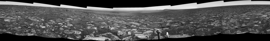
So, Sol 2768/69 navcam pan. Just gorgeous !
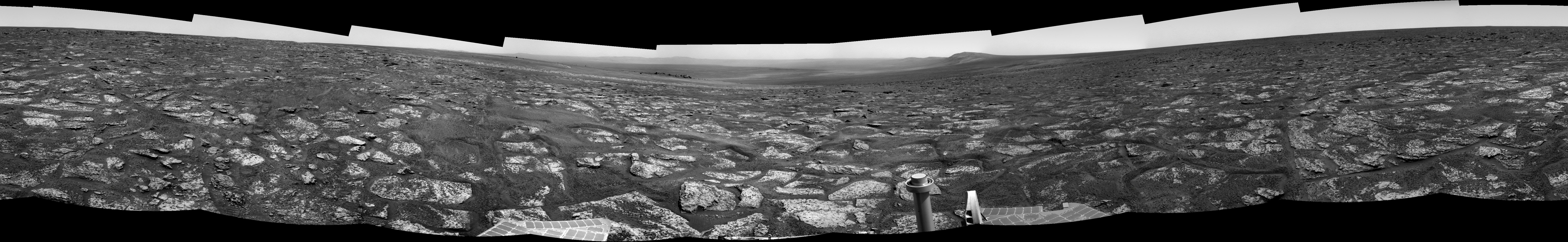
Here's an annotated version of Stu's phil'o'visioned Endeavour panorama. I hope that I set the names correctly. If not then just enjoy the colors...
Yikes, this does really show us CY well. 3x philovision from mhoward's navcam mosaic:
Click to view attachment
It almost looks as though CY is "draped" on the slope, but of course we're no doubt seeing just the "tip of the iceberg"...
Click to view attachment
It almost looks as though CY is "draped" on the slope, but of course we're no doubt seeing just the "tip of the iceberg"...
I find the enormity of Endeavour's central mound a big surprise from the ground images, compared to the orbital shots with no obvious rippling that we've been accustomed to at Meridiani craters... is it a thick dust blanket - or what??
.
Wow... everyone.....those philovisions are awesome.
really bring out the features in this huge crater... i finally understand what i am looking at.
Craig
really bring out the features in this huge crater... i finally understand what i am looking at.
Craig
QUOTE (eoincampbell @ Aug 8 2011, 06:54 PM)
I find the enormity of Endeavour's central mound a big surprise from the ground images ...
Me too!
QUOTE (Gladstoner @ Aug 8 2011, 07:03 PM)
I wonder if that central mound could be an uneroded, more modest 'Gale mound'.
That was my first thought. Maybe the experts around here will point how it is a central peak, but it doesn't look one to me. I think I can see some layering.

Interesting how the ground view makes it clear that some of the vague markings seen from orbit inside Endeavour are indeed horizontal layers exposed in the central mound. So yes, maybe it's a mini- Gale mound. Here's a correlation between the two views, using fredk's version of Mike's Navcam mosaic, and stealing an orbital view from Tesheiner's master map.
Click to view attachment
I'm also struck by how close to Oppy the visible part of the central mound is- there's a fairly narrow trough around the edge of Endeavour separating us from the mound. Fascinating...
John
Click to view attachment
I'm also struck by how close to Oppy the visible part of the central mound is- there's a fairly narrow trough around the edge of Endeavour separating us from the mound. Fascinating...
John
QUOTE (MoreInput @ Aug 8 2011, 02:58 AM)
I made with Google Mars a cross section through the east crater rim from Cape York to Cape Byron. ...
While the Google Earth elevation profile tool is quite useful, you must be careful using it on Mars. The Google Mars elevations are not accurate in areas where elevations change more rapidly than the MOLA shot point coverage does.
Nice job with those identifications, John. Things are definitely getting clearer...
From Maxwell:


From Maxwell:
QUOTE
The drive we uplink today will actually take us physically onto Cape York. So. *Freaking*. Excited.
The complete colourized navcam view of Endeavour Crater on
Sol 2679.
Jan van Driel
Click to view attachment
Sol 2679.
Jan van Driel
Click to view attachment
QUOTE (MoreInput @ Aug 8 2011, 01:21 AM)
Did Oppy or even Spirit found such boulders (> 1,50 meters)? I don't think so we have seen such big thing yet in the last 8 years.
You may be right. I thought Wopmay in Endurance might be that big, but Wopmay was only a meter or so across, though other rocks near it may have been larger. Which makes the boulders near Odyssey all the more interesting, because they appear to be in a location that's more prone to wind-driven erosion than the interior of Endurance.
I have a Question?
I know how important it is for Opportunity to find phyllosilicates at Cape York on Mars but has any rover or any orbiting
Satellite ever found any rare Metals like Gold, Silver etc. I've all ways wondered if Mars does have any rare metals?
I would also like to say Thanks to all the image wizards in UMSF for doing such a Great Job. I love reading all the posts
members put in here. Just a fan watching this amazing time for Opportunity. The flux capacitor on Oppy must be reading
Full right now.
Take Care,
Bobby
As far as I know, the rovers arn't capable of detecting any precious metals like gold or silver. Please correct me if I'm wrong though. APXS can detect elements like aluminium, iron, nickel, sodium, magnesium, titanium, silicon, calcium, chlorine, and some other elements possibly carbon and oxygen I believe.
Single color (L257) image from sol2667 has seen the light of day on Exploratorium.
3 images are from this sequence:
Click to view attachment
Crater on far wall of Endeavour can still be seen, unlike now.
3 images are from this sequence:
QUOTE
02667 p2373.28 6 0 0 5 1 12 pancam_Endeavour_rim_2x1_L257
Click to view attachment
Crater on far wall of Endeavour can still be seen, unlike now.
That's due to the increment on tau on this latest sols, I think.
Where are are going after Cape York ?
I've been confused for a week or two as I was expecting Cape York to be a big hill, it's like a gentle rise really.
I just realised today that that's Endeavour Crater in the distance.
That's exactly what confused me.
I've been confused for a week or two as I was expecting Cape York to be a big hill, it's like a gentle rise really.
I just realised today that that's Endeavour Crater in the distance.
QUOTE (fredk @ Aug 8 2011, 05:58 AM)
First conclusion: the step up to CY is really tiny!
That's exactly what confused me.
The Endeavour central mound looks to me like its a windblown basaltic sand dune like el dorado at spirits site...i'm not seeing any layering there....besides it seems to be too dusty and dangerous for Oppy to drive on it...most likely it will get stuck just as it did at purgatory!
Hmmm, Oppy could be doing good 'steal her thunder' work on that central mound before Curiosity arrives at Gale!

P
P
I expect we'll be watching Oppy working around the rim for quite some time.
That crater down there is her entire 7.5 year journey laid out in front of us.
That central mound is a long way off and with a lot of ground inbetween.
And please don't even think about talking Iazu.
First job, characterise the geology, lock down the phyllosilicates and then sniff out what else we can find out about Mars' past enivronmental conditions.
That's a prime mission right there.
QUOTE (Julius @ Aug 9 2011, 08:13 AM)
The Endeavour central mound looks to me like its a windblown basaltic sand dune....
My opinion (a two cent value!) is that the mound is the same built up sulphate layers that surround Endeavour and cover all of Meridiani that Opportunity has traversed. The reason it is a mound is because wind patterns, influenced by the crater rim, have eroded away more of the material filling the crater near the crater rim, leaving more in the center.
QUOTE (Toma B @ Aug 8 2011, 12:07 AM)
Just for fun.
Final part of that GIF series centered roughly on Cape Tribulation.
It is Philovisioned drive direction panoramas after sols 2671,2674,2676 and 2678.
Click to view attachment
It can clearly be seen that last drive (sol 2678) was shorter. Also, since the Endeavour crater "opened" there is no point in making this GIF. If we start moving towards Cape Trib. once I will try to continue this series.
By the way, this GIF has been placed in the LTP reports at our SOWG meetings both Friday and Monday. I forwarded it on to the team Friday morning, and it got everyone's attention.
It is referred to as the "now infamous UMSF .gif"!
-m
With regard to the layering in the central mound and edges of Endeavour, for years (since I first advocated that Oppy head this way and was laughed at for such a crazily ambitious notion), it has made sense to me that many of these features were neatly interpretable as remnant "beaches" and other associated features from an evaporating ice-covered lake which once filled the crater. This may be a bit of a stretch, but it seems reasonable to me that, if the plains were saturated by groundwater (which appears to be the case), then the lower altitude Endeavour ought to be filled with water. What I don't see is flow features, so if this notion is correct, the source of the water would have been entirely groundwater seeping through permeable geology.
This is a "lo-fi" version of our main content. To view the full version with more information, formatting and images, please click here.