Help - Search - Members - Calendar
Full Version: Post Conjunction: Santa Maria to Cape York
Unmanned Spaceflight.com > Mars & Missions > Past and Future > MER > Opportunity
Pages: 1, 2, 3, 4, 5, 6, 7, 8, 9, 10, 11, 12, 13, 14, 15, 16, 17, 18, 19, 20, 21, 22, 23, 24, 25, 26, 27, 28, 29, 30, 31, 32
Tesheiner
QUOTE (nprev @ Apr 2 2011, 08:56 AM) *
I have little love for kapton. It's very good insulation, but not very durable over time.

Who could ever imagine that this mission would last 7+ years? smile.gif
mhoward
Sol 2554 left Pancam

stevesliva
QUOTE (Tesheiner @ Apr 2 2011, 12:18 PM) *
Who could ever imagine that this mission would last 7+ years? smile.gif

I wonder if nprev's comment has more to do with KC-135s or B-52s lasting 7 decades.
nprev
...yeah, kinda sorta! wink.gif

Kapton's just nasty stuff, is all. When it goes, it goes for good. It's REALLY good at producing hard-to-find high-resistance shorts to ground & all kinds of quirkly little problems. I've had too many long days and nights troubleshooting problems with kapton-clad wiring and it's left me an aged & bitter SOB, so don't mind me at all, please! tongue.gif

[edited for specific reason why I hate kapton]
Phil Stooke
"it's left me an aged & bitter SOB"

Ohhh... that's what did it!

Looking ahead:

Click to view attachment


Phil
nprev
You got me cold, Phil; kapton is the devil! tongue.gif

EDIT: Forgot to add the traditional "Watch it, Map Boy!" Apologies for the oversight... smile.gif
Phil Stooke
And I foolishly edited the last post to insert an image, so now it's in the limbo of the previous page.

Phil
walfy
The RAT could chew off the Kapton if it becomes a problem. Probably not.
djellison
QUOTE (walfy @ Apr 2 2011, 11:49 AM) *
The RAT could chew off the Kapton if it becomes a problem. Probably not.


No it couldn't. Firstly - even a healthy arm wouldn't be commanded to touch that as it's well within the keep-out zone for self-contact. For goodness sake, it's ON A SUSPENSION STRUT and RIGHT NEXT TO TO CABLES THAT DRIVE A WHEEL. You would have to actually want to kill the rover to put the rat to work over there.

Secondly - the arm ISN'T healthy - and can't reach there anymore anyway.
Stu
Oh, I love this rock...

Click to view attachment
jvandriel
Looking back and around on Sol 2552 with
the L0 Navcam.

Jan van Driel

Click to view attachment
Stu
Some very interesting features up ahead - circular, pedastal-like domey...things... which have been catching my eye for quite a while now. There are many more of them closer to Cape York, so it'll be interesting to get a close look at some of them early on in our drive.

To provide scale I've dropped some virtual Oppys onto this image, which shows one possible route (bottom to top = west to east... ish... kind of...) for the next few sols, taking her towards the features.

Click to view attachment

I've made a lot more images relating to this, but, again, rather than bombard UMSF's server with them I've put them in a post over on my blog, which I hope some of you will take a look at:

http://roadtoendeavour.wordpress.com/2011/...the-great-plain
fredk
(Stu, I think that should read bottom to top.)

Those domey things are interesting, and I don't recall seeing features like them before. They're surrounded by the "darkened terrain" that mhoward pointed out long ago. Though I can't see any depth on your 3D pic, Stu, I get the impression the domes are a bit higher than the dark terrain. But hopefully we'll find out soon. Presumably the "domes" are the insides of old craters that were perhaps filled with a harder material than the outsides (unless they're lower than the dark terrain, in which case the outsides were harder).

We can also see how much we've climbed recently looking back at Santa Maria - the rim doesn't even cut the horizon any more:
http://qt.exploratorium.edu/mars/opportuni...0M1.JPG?sol2554
Phil Stooke
Right Fred - plus that pic shows why Santa Maria was so hard to spot coming from the uphill side.

Looking at the little hazard avoidance dance steps, you have to ask - why worry?

Phil
mhoward
Looking back - sol 2552 Navcam


Sol 2554 Navcam


That last one in particular should look great with PDS images instead of compressed JPGs.
nprev
What's with the little wheel slews in the tracks every meter or so in the latter panorama? Is that an anti-dig-in measure, or a traction check?
fredk
Check out this post.
nprev
Yeah, I saw that, Fred, but the puzzle pieces didn't click for me till just now; thanks!
Tesheiner
QUOTE (Stu @ Apr 3 2011, 11:10 AM) *
Oh, I love this rock...

Uh! Really?!? smile.gif

Click to view attachment
eoincampbell
Heavy, man! blink.gif smile.gif
Stu
We've seen something like that before...

Click to view attachment

cool.gif
nprev
laugh.gif

However, in sharp contrast, Big Rock requests that you call it "Daddy"...
Stu
Large 3D view of the road ahead for Oppy... liking the misty hills on the horizon and the countless small stones strewn over the ground...

http://twitpic.com/4gxhzi/full
Stu
Slightly more realistic view of our big ugly crumbling friend...

Click to view attachment

(what is its real name? I'm a bit confused, I'll be honest...)
jamescanvin
QUOTE (Stu @ Apr 5 2011, 11:49 AM) *
what is its real name?


Bagua
Stu
Thanks, James.
fredk
On 2556 we were sitting on one of the slightly darker patches visible in the orbital imagery. Looking south, you can see more dark patches (circled in this navcam view), that basically look like low areas surrounded by light ripples:
Click to view attachment
You can see more to the north, in the upper right of this frame:
http://qt.exploratorium.edu/mars/opportuni...0M1.JPG?sol2556
Tesheiner
I saw that too and made this polar view in an attempt to correlate it to the HiRISE image.
Click to view attachment

No luck. sad.gif
Phil Stooke
So... adding a bit of a stretch factor to Tesheiner's polar pan, and comparing it with Tim Parker's latest route map at JPL, we get this:

Click to view attachment

Phil
fredk
For my millennial post, let me say that I agree with your ID's, Phil. I'll just indicate the darkened areas I circled in my post above by circling the corresponding areas on your map, Phil:
Click to view attachment
Enhancing the orbital view really brings out some fascinating detail in this area. It sure would be cool to know the whole history here...
Tesheiner
Thanks a lot! smile.gif
I logged-in just to post yet another map update (sol 2558) and found your posts above. Now, I'll redo the 2556 plot with Phil's ID and post the map later on (edit: done).

Meanwhile just say that today's drive was "only" 65m ESE to the vicinity of crater "C".
Click to view attachment
Phil Stooke
Scott tweeted that the drive would be longer, stopping mid-way for some crater imaging. Is it possible your map shows the midpoint of the drive, or was the drive terminated early?

Phil
Astro0
Admin: A few posts on the Peugeot advert were moved to the Mars Rovers in Advertising thread started last year when this first appeared.
Tesheiner
QUOTE (Phil Stooke @ Apr 5 2011, 10:03 PM) *
Scott tweeted that the drive would be longer, stopping mid-way for some crater imaging. Is it possible your map shows the midpoint of the drive, or was the drive terminated early?

The latter, I would say.
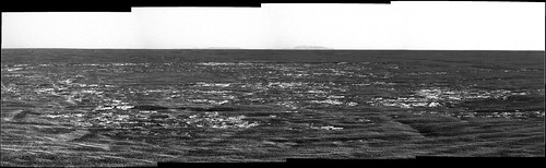
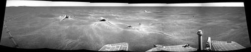
Yestersol pictures are still missing but, based on the info available on the pancam website, the "post-drive" hazcam images correspond to the sequences I'm highlighting here below and no movement actually happened between the two navcam mosaics with SeqIDs 1993 (mid-drive) and 0663 (post-drive).
QUOTE
02558::p0025::01::0::0::0::0::0::0::mer_b_sunfind_parms_left_eye_525_exp
02558::p0663::03::6::0::0::6::0::12::navcam_3x1_az_108_3_bpp
02558::p1201::07::2::0::0::2::0::4::front_haz_penultimate_1bpp_pri17
02558::p1211::03::2::0::0::2::0::4::ultimate_front_haz_1_bpp_pri_15
02558::p1254::02::2::0::0::2::0::4::front_haz_fault_pri15_4bpp
02558::p1301::06::2::0::0::2::0::4::rear_haz_penultimate_1bpp_pri17
02558::p1312::07::2::0::0::2::0::4::rear_haz_ultimate_2_bpp_pri15
02558::p1354::01::2::0::0::2::0::4::rear_haz_fault_pri15_4bpp
02558::p1933::06::6::0::0::6::0::12::navcam_3x1_az_45_2_bpp
02558::p2391::27::8::0::0::8::2::18::pancam_drive_direction_4x1_L2R2
02558::p2600::14::2::2::0::0::2::6::pancam_tau


For some reason, the drive "faulted" after taking the midpoint navcam mosaic.
jvandriel
The Pancam L2 view on Sol 2556.

Jan van Driel

Click to view attachment

Phil Stooke
... and doing a 10x stretch of that image, we get a sense of what those mounds might look like close up. Looking at this, it seems most likely that a layer has been stripped away, leaving those mounds and a larger area at the right - but so thin you can only see it if you do this to the image.
Phil

Click to view attachment
MoreInput
QUOTE (Tesheiner @ Apr 6 2011, 05:53 PM) *
That makes around 500m / week --> only 3 months to reach Cape York.
(I know, I know I shouldn't be doing this kind of math.) laugh.gif


It's about 770 meters since Oppy left Santa Maria, in just 17 sols.
What's the current odometer?
Tesheiner
Around 27500m.
Stu
Loving the depth of field here...

Click to view attachment
vikingmars
QUOTE (Tesheiner @ Apr 6 2011, 06:53 PM) *
(I know, I know I shouldn't be doing this kind of math.) laugh.gif

Why not ? Some friends told me recently that they had to made route and timing projections to fine-tune Oppy's operational budget and staff issues in the near future. But, of course, any incident can occur while travelling, so timings are only guesses... As we used to say in France : "Ne soyons pas plus royalistes que le Roi" ("Let us not be more royalist than the King") !
Tesheiner
QUOTE (vikingmars @ Apr 7 2011, 10:08 AM) *
Why not ?

Route and time projections are absolutely valid calculations, of course! smile.gif
What is not so valid, and that was the reason to my previous comment, is the easy math extrapolating data from a single week of driving.
climber
Mean per sol from October 12th to December 8th (before getting to Santa Maria) was 39.9 m.
What about that viKINGmars laugh.gif
Stu
Beautiful horizon...

Click to view attachment
MahFL
It's just like the approach to the Columbia Hills all over again smile.gif
Phil Stooke
Here's a comparison of the view from Concepcion crater and the view now (from Stu's post above), with a 10x stretch of course.

Phil

Click to view attachment
Phil Stooke
And closing in on Cape Tribulation, there's a crater on its slope that I had not noticed before, though it was probably visible a long way back.

Phil

Click to view attachment
Tesheiner
Could it be a JPEG artifact? I can't see it on the HiRISE pics. huh.gif

WRT today's drive, I have no time to work on the map but I checked the "telemetry" and Opportunity covered around 140m today! Let's keep this pace.
Phil Stooke
This link:

http://www.unmannedspaceflight.com/index.p...st&id=23696

to one of Stu's images also shows it - so not an artifact, I'm pretty sure. I also tried to match it with HiRISE, and still not sure, but I'm still thinking about it. The crater it could be seems a bit off where I would expect it.

Click to view attachment


EDIT - should be about here... subdued, and facing the sun so no shadow in it...? Maybe I'll say it's not a crater but various patches of rock.


Phil
ngunn
I don't know if it helps with that crater, but here's the link back to Nirgal's 3Ds of Tribulation: http://www.unmannedspaceflight.com/index.p...st&p=156417
Phil Stooke
Interesting! I forgot about that. Looks like my feature shows up better on that - the last one of the set.

Phil
This is a "lo-fi" version of our main content. To view the full version with more information, formatting and images, please click here.
Invision Power Board © 2001-2024 Invision Power Services, Inc.