Help - Search - Members - Calendar
Full Version: Post Conjunction: Santa Maria to Cape York
Unmanned Spaceflight.com > Mars & Missions > Past and Future > MER > Opportunity
Pages: 1, 2, 3, 4, 5, 6, 7, 8, 9, 10, 11, 12, 13, 14, 15, 16, 17, 18, 19, 20, 21, 22, 23, 24, 25, 26, 27, 28, 29, 30, 31, 32
monty python
QUOTE (Juramike @ Aug 6 2011, 06:19 PM) *
So what is this and how did it form?

http://qt.exploratorium.edu/mars/opportuni...YMP1944R0M2.JPG

It this a little dust-filled deflation hollow? Have we seen things like this before?


I personally love the deflation hollow theory of the little depressions we have been seeing, and i think this is one of them. The bedrock void creating it could be enhanced by the fact we are so close to the rim of endeavour.
walfy
It's not on the exploratorium servers yet, but Matt's got a fine shot of Odyssey Crater and Spirit Point on his blog already. Lot's of fine boulders there. Thanks, Matt!
Sunspot
Arrrh... shouldn't keep staying up to 2.35am to see the latest images blink.gif blink.gif blink.gif

worth it though

http://qt.exploratorium.edu/mars/opportuni...00P1944L0M1.JPG

http://qt.exploratorium.edu/mars/opportuni...YMP2383L2M1.JPG
fredk
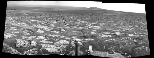
Stunning view looking east to Spirit Point, and beyond to the bottom of Endeavour. This is our first good look at the "step" up to CY, and at first glance it looks pretty navigable to me - better than most of Home Plate:
Click to view attachment
Another incredible view, looking south across Botany Bay, to Solander and Tribulation. Sutherland Point/Nobby's Head are just starting to show on the far right (this view was before drive, so from the 2676 location):
Click to view attachment
Can't wait to see those L257's in full colour... wink.gif
mhoward
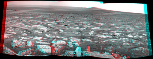
2678 Navcams:


eoincampbell
Absolutely stunning anaglyphs for an absolutely stunning view, thank you gentlemen, I'm stunned !
ElkGroveDan
Is it really that lumpy? Or is it an artifact of the anaglyph? If it is, it makes me wonder if the steering actuator might be an issue crossing that kind of relief, even driving backward.
mhoward
I was kind of wondering the same thing, Dan. I think Pancam anaglyphs like this tend to exaggerate, but it must be at least somewhat bumpy? Obviously she's been over ground like this before but it may have been a while. (Edit: Not Pancam, Navcam. It's late.)
Eutectic
QUOTE (mhoward @ Aug 6 2011, 08:55 PM) *
I was kind of wondering the same thing, Dan. I think Pancam anaglyphs like this tend to exaggerate, but it must be at least somewhat bumpy? Obviously she's been over ground like this before but it may have been a while. (Edit: Not Pancam, Navcam. It's late.)


The bumpiness is reminiscent of the surface of eroded ejecta blocks in the aprons surrounding Santa Maria ( http://marsrovers.jpl.nasa.gov/gallery/pre...cam360_cypA.jpg ) and Endurance ( http://marsrovers.jpl.nasa.gov/gallery/pre...yp_A-B118R1.jpg ) only more so. Can't wait to get a closer look at the "step" up to Cape York -- could be the first new rock type since Eagle and Endurance (excluding meteorites).
tanjent
Is there a geologist's term of art for "knife-edged upjutting shingles"?
Maybe a sign warning of severe tire damage would be in order, even if Oppy's are made of aluminum.
James Sorenson
What a wonderful place! smile.gif

Click to view attachment
PaulM
QUOTE (ElkGroveDan @ Aug 7 2011, 02:43 AM) *
Is it really that lumpy? Or is it an artifact of the anaglyph? If it is, it makes me wonder if the steering actuator might be an issue crossing that kind of relief, even driving backward.

I could imagine one of Oppy's wheels getting stuck in a crevace between two rocks in this sort of landscape. I hope that the drivers go very carefully to Spirit point.

It would be very tempting to me to attempt to drive to those inviting black rocks at Spirit Point in one SOL. Just imagine the first in-situ rocks other than Meridiani sediments that that Oppy has encountered in its entire mission look like they are only 100m away.
Julius
So when is the final drive to Spirit point planned?
Stu
Well, here we are...

Click to view attachment
Julius
Not quite there....almost there...how high is that step onto Spirit point?
jvandriel
Sol 2678
The Navcam L0 view in colour.

Jan van Driel

Click to view attachment
PaulM
QUOTE (Julius @ Aug 7 2011, 07:31 AM) *
Not quite there....almost there...how high is that step onto Spirit point?

The rocks in Botany Bay were deposited next to the crater rim and so may feature interesting sedimentary structures. I guess that they will also need to be looked at in detail sooner or later.
Astro0
Just to put Opportunity's journey across Meridiani Planum from Eagle Crater to Endeavour Crater in some kind of context to the vistas we are seeing now.
Here's an image showing Opportunity's path (in yellow) and that same path (in purple) [in reverse] marked out across Endeavour Crater.
Click to view attachment

Opportunity and all of us have travelled far! blink.gif

EDIT: Of course, the purple path doesn't take into account the topography, terrain and certainly not the last 7.5+ years of trials and triumphs.
MoreInput
Let's drive 7 years long to the other side of the crater just to get a better view of Cape York rolleyes.gif ?
neo56
I have added the names of the places of interest on the Mick Navcam panorama. Please tell me if I'm wrong, and don't hesitate to add the position of the rover on the 3D view of Cape York.
Julius
I'v been tryimg to look for crism data of CY. Could someone post a link? Thanks
neo56
QUOTE (Julius @ Aug 7 2011, 10:07 AM) *
I'v been tryimg to look for crism data of CY. Could someone post a link? Thanks


There is a paper of Wray et al. (2009) published in Geophysical Research Letters where the distribution of phyllosilicates and sulfates on Cape York is shown, retrieved from a CRISM observation. Red is for Fe/Mg-phyllosilicates and cyan is for polyhydrated sulfates.

Stu
A lone, lonely MI image came down overnight... tweaked it a bit...

Click to view attachment
Julius
Thanks neo for that..I was wondering at which point along CY would oppy get to sniff phylosilicates.
Nomadd22
QUOTE (Astro0 @ Aug 7 2011, 03:29 AM) *
Just to put Opportunity's journey across Meridiani Planum from Eagle Crater to Endeavour Crater in some kind of context to the vistas we are seeing now.
Here's an image showing Opportunity's path (in yellow) and that same path (in purple) [in reverse] marked out across Endeavour Crater.

Opportunity and all of us have travelled far! blink.gif

EDIT: Of course, the purple path doesn't take into account the topography, terrain and certainly not the last 7.5+ years of trials and triumphs.


Looking at that image makes me remember comments regarding not worrying too much about getting stuck in Endurance crater, since it was a great place to study, and that was about as long as the mission would last anyhow.
empebe
QUOTE (dilo @ Aug 3 2011, 10:36 AM) *
Nice, Astro0... I used your mosaic for an artistic wallpaper, with false colors, artificial sky and enhanced details/contrast on far plane:
Click to view attachment Click to view attachment
Second version is 2x vertical stretch (which I prepfer...!)
Stunning.
Mike

ElkGroveDan
QUOTE (Astro0 @ Aug 7 2011, 01:29 AM) *
Here's an image showing Opportunity's path (in yellow) and that same path (in purple) [in reverse] marked out across Endeavour Crater.

It looks to me that if you pull that purple string tight it just about gets us to Iazu. (Just sayin' rolleyes.gif )
ElkGroveDan
QUOTE (Stu @ Aug 7 2011, 04:16 AM) *
A lone, lonely MI image came down overnight... tweaked it a bit...

Thanks for catching that Stu. Tweaked a bit more with my secret tool on Opportunity, the MIFF (microscopic imager fill flash) -- shhhhh hardly anyone knows about it.
fredk
QUOTE (ElkGroveDan @ Aug 7 2011, 03:43 AM) *
Is it really that lumpy?
Just what the rocker-boggie system was designed for! I'm sure Oppy's eager to stretch her joints a bit after all that flat terrain...

QUOTE (PaulM @ Aug 7 2011, 09:08 AM) *
The rocks in Botany Bay were deposited next to the crater rim and so may feature interesting sedimentary structures.
Indeed - remember that Botany Bay is in a large region of hydrated bedrock, according to this map.

QUOTE (neo56 @ Aug 7 2011, 11:03 AM) *
I have added the names of the places of interest... Please tell me if I'm wrong
Your Cape Byron is actually Cape Dromedary, and your Dromedary is Point Hicks. You could also add Sutherland Point/Nobby's Head on the far side of Botany Bay. (See map here.)
ElkGroveDan
QUOTE (fredk @ Aug 7 2011, 07:16 AM) *
Just what the rocker-boggie system was designed for!

Exactly. However it has been redesigned by circumstances, which is why I raised the question.
centsworth_II
QUOTE (Julius @ Aug 7 2011, 07:22 AM) *
Thanks neo for that..I was wondering at which point along CY would oppy get to sniff phylosilicates.
Concerning phylosillicates at Cape York, these posts from Stu's blog "The Road to Endeavour" are definitely worth a read (or re-read).

An interview with Ray Arvidson
WHY are we going to Cape York?
ElkGroveDan
And here she is taking the MI on 2678. Kind of cool that you can make out the Odyssey Crater debris in the upper left corner of the image.
Matt Lenda
QUOTE (Julius @ Aug 6 2011, 10:55 PM) *
So when is the final drive to Spirit point planned?

Monday.

I didn't get to hear much of the goings-on on Friday -- I just know they packed that plan full of goodies -- because I was tied up with Juno. They *may* further break the remaining ~75 meters into several drives, though our imagery seems to give us great data of the terrain.

-m
HughFromAlice
Been a while since I've posted in this thread - so much to do in life! Great to see so many interesting posts. smile.gif

Oppy has arrived at such an awesome place that I thought that I would have fun and imagine a sunrise..... so combined some Sol2676 Navs with Sol2674 Pans and came up with this. Anyway the sun's roughly in the right place as per Nav cam pic. Almost like a sunrise in the winter in Central Australia with the blue haze!!! Would have liked to be a bit more accurate but looked at the clock and it's well into the night. huh.gif

Click to view attachment

For the mid res version..... https://picasaweb.google.com/10220631534056...idRes_20110807#
Will probably post the high res version later when I get time (My software hangs when trying to export to a high quality JPEG).
Tesheiner
Just finished my vacations, I'm still unpacking things, but couldn't resist to check in and see the images from these last 24h and they are just wonderful!
marsophile
QUOTE (Astro0 @ Aug 7 2011, 01:29 AM) *
Opportunity and all of us have travelled far!


...sitting on the shoulders of giants!
Bobby
Even Know Endurance Crater is Amazing in Size.

There is something about Santa Marie that I liked the Most.
I think it's the age and it had personality.
Still my favorite with Eagle a close 2nd.
hendric
QUOTE (Matt Lenda @ Aug 6 2011, 04:40 PM) *
Yes and no. That's an extraordinarily complex issue, not least because we have to ask the question, "What clock?" and the question, "Relative to what?"
We have several ways of mitigating the drift, none of which are trivial. There's no real *reset* button to do it. (And for good reason.)
We have seen less drift of this particular clock when the rover is warmer. The theory is well supported by the data, but we have yet to implement the fix in tactical activities. It's low on our radar.
I'll stop talking before I get in over my head.
-m

Interesting stuff Matt! I've had to deal with oscillators in my line of work. Most issues have been around the Real Time Clock. I remember one customer routed their digital 32K output right underneath the 32K crystal, which is a big no-no. Caused so much feedback noise into the crystal that it was running at around 130 kHz. Another funny issue was one customer complaining about our RTC being off 2 minutes after "only" a month. We had to explain to them that the 50ppm for a typical 32kHz crystal meant that over a month, you could be up to 2 minutes off! We did have options for calibrating the crystal, but they didn't do that during their manufacturing run because it took too long. LOL, fun times.

I've also had to do some wireless stuff as well, WiFi and GSM. For the non-engineers, frequency crystals can be pretty accurate (As long as your design isn't noisy), typically 50 to 200ppm. Their biggest variance short-term is due to temperature, as Opportunity is experiencing, or due to aging. For items requiring precision, what is typically done is using a tiny chip to adjust the frequency based on the ambient temperature, reducing the frequency variability significantly, usually to less than 1ppm. These are called Temperature Compensated Crystal Oscillators, or TCXOs. For the ultimate in frequency control, the crystal is stuck inside an oven, guaranteeing there is no temperature change at all, and getting < .001ppm, called Oven-Controlled Crystal Oscillators, or OCXO. I think the "ultra stable oscillators" discussed for radio science uses these types of oscillators to provide the stable frequency for measuring changes due to gravity.

For Oppy it sounds like the oven itself might be aging and not keeping the crystal at the ideal temperature. Another possibility might be a decoupling capacitor aging, or solder itself starting to exhibit increased resistance due to temp. cycles.

For the curious, there is some more information here

http://www2.electronicproducts.com/Underst...b2005-html.aspx
fredk
Spirit Point pancam anaglyph. Definitely a signature view of the mission.
Click to view attachment
fredk
The mystery men have emerged again to help give us a sense of scale at this milestone in our journey. As usual, the men are 2 metres high to top of hat. Distances are from Tesheiner's map, converted to pixels based on a 45 degree FOV for navcam. Closest man is standing just on top of the step up to CY, and farther man is at distance of rock cluster behind Odyssey.
Click to view attachment
First conclusion: the step up to CY is really tiny! Second conclusion: Those rocks boulders are really big!
Eutectic
QUOTE (fredk @ Aug 7 2011, 10:58 PM) *
The mystery men have emerged again to help give us a sense of scale at this milestone in our journey.
...
First conclusion: the step up to CY is really tiny! Second conclusion: Those rocks boulders are really big!


Please thank the mystery men for appearing at just the right times. They'd be pretty hard to spot on the far side of Endeavour!

Odyssey is in the same size range as Beagle crater, but Odyssey's free-standing boulders are much bigger (http://www.unmannedspaceflight.com/index.php?act=attach&type=post&id=6741). Possible explanations include Odyssey being fresher than Beagle, Cape York blunts wind erosion, and/or the boulders are just tougher.
MoreInput
QUOTE (fredk @ Aug 8 2011, 06:58 AM) *
Second conclusion: Those rocks boulders are really big!

Did Oppy or even Spirit found such boulders (> 1,50 meters)? I don't think so we have seen such big thing yet in the last 8 years.
Toma B
Drive direction Pancams taken after sol2678 drive are down.
QUOTE
02679 p2384.28 8 0 0 8 2 18 pancam_drive_direction_4x1_L2R2


Click to view attachment

BTW is there any estimation on hight of those hills?
MoreInput
Pancam panorama of Sol 2769

We see Cape York and Cape Trib in one pancam panorama, now ohmy.gif .
jvandriel
Here is the Pancam L2 Panoramic view on Sol 2679
in colour.

Jan van Driel

Click to view attachment

ElkGroveDan
QUOTE (Toma B @ Aug 7 2011, 11:28 PM) *
BTW is there any estimation on hight of those hills?

The highest points on Endeavour's rim are roughly 500 feet above Opportunity's present position and about 2000 feet above the lowest point of the crater floor.
MoreInput
I made with Google Mars a cross section through the east crater rim from Cape York to Cape Byron.

It is just a rough profile. According to this Cape Trib is about 50, maybe 60 meters higher than our current position.
James Sorenson
The Sol-2679 Pancam drive direction in 3D ohmy.gif
Click to view attachment
Toma B
Just for fun.
Final part of that GIF series centered roughly on Cape Tribulation.
It is Philovisioned drive direction panoramas after sols 2671,2674,2676 and 2678.

Click to view attachment

It can clearly be seen that last drive (sol 2678) was shorter. Also, since the Endeavour crater "opened" there is no point in making this GIF. If we start moving towards Cape Trib. once I will try to continue this series.
Ant103
Back from vacation. Unable to download and upload pictures because the network was slow as hell.

Anyway, I gain some late.

Sol 2678 color pan :


Same sol, navcam :


Sol 2679 pancam :


And amazing pics you've made there smile.gif. And in a really short time. The excitement about this leg of the travel sure is true !

EDIT : this picture/desktop picture wink.gif
This is a "lo-fi" version of our main content. To view the full version with more information, formatting and images, please click here.
Invision Power Board © 2001-2024 Invision Power Services, Inc.