Help - Search - Members - Calendar
Full Version: Jezero Delta Campaign, Sols 414-1000
Unmanned Spaceflight.com > Mars & Missions > Perseverance- Mars 2020 Rover
Pages: 1, 2, 3, 4, 5, 6, 7, 8, 9, 10, 11, 12, 13, 14, 15, 16, 17, 18, 19, 20, 21, 22, 23
neville thompson

Gigapan - PERSEVERANCE 684
© NASA/JPL-Caltech/MSSS/ASU/NeV-T
tau
Sol 686 SuperCam Remote Micro-Imager mosaic.
The glint at pixel 6660 from the left, 800 from the top is real, not an image defect.
It can be seen in two overlapping raw photos at the same location.
It is probably a shiny piece of hardware.

Click to view attachment

tau
Mastcam-Z context with "marsonaut" for scale and Navcam context for the SuperCam RMI mosaic in the preceding post.

Click to view attachmentClick to view attachment
neo56
My take on the self-portrait of sol 684 with the 9th sample tube. How many of them can you spot on the image? I spotted a total of 6.


scalbers
Sol 684 panorama, along with a large version derived from Paul's tiled NavCams and pointing info. A color correction was applied to yield soil x,y chromaticity values in the neighborhood of 0.434, 0.394 assuming a white point at 5800K.

Click to view attachment

Recent drives are turning to the north towards the delta. We can watch the changing landscape in this extended drive animation from Sol 394 to the present.
Phil Stooke
This is the sol 684 location in circular form.

Phil

Click to view attachment

Click to view attachment
Phil Stooke
And because I had an idle hour (one of those blissful times when there were only about 4 other things I should have been doing), and a set of Paul's images I had not used yet... here is sol 681.

Phil

Click to view attachment

Click to view attachment
neo56
Backup depot is complete! 10th and last sample tube was dropped off on sol 690. It contains a sample from "Amalik" sedimentary rock.

neo56
Sunrise imaged on sol 691. Some noctulescent clouds are visible. Navcam Left, 6:14 am LMST.

Phil Stooke
The various circular views I have been posting included the central portion cropped to omit the horizon section. They are roughly in map geometry except that I make no corrections for relief distortions and the composites contain some distortions from the mosaicking process. Despite that they do roughly correspond to maps so here I have fitted them together to cover the cache area.

Phil

Click to view attachment
fredk
QUOTE (neo56 @ Jan 30 2023, 09:53 PM) *
Sunrise imaged on sol 691. Some noctulescent clouds are visible.

Those look pretty subtle for noctiluscent - they look like ordinary cloud to me.
Phil Stooke
Sol 693 drive - this is from Paul's images.

Phil

Click to view attachment

Click to view attachment
tau
Sol 695 SuperCam Remote Micro-Imager mosaic with sol 694 Navcam context

Click to view attachmentClick to view attachment
Phil Stooke
This is the sol 694 location from Paul's images. I didn't have time to add the upper tier images.

Phil

Click to view attachment

Click to view attachment
StargazeInWonder
The perpendicular fractures on the right side of the Micro-Imager image in post 613 are really eye-catching. Is there a 90° structure in underlying crystals or is something else going on?
serpens
Given the 90 degree cleavage my somewhat wet fingered guess would be a fragment of plagioclase feldspar. A reasonably high probability actually given that the Jezero catchment encompasses part of the highest concentration of plagioclase identified by TES.
scalbers
Sol 693 panorama, along with a large version derived from Paul's tiled NavCams and pointing info.

Click to view attachment
scalbers
Sol 694 panorama, along with a large version derived from Paul's tiled NavCams and pointing info.

Click to view attachment

Sol 695 panorama and large version.

Click to view attachment

We can watch the changing landscape in this extended drive animation from Sol 394 to the present.
neville thompson

Gigapan - PERSEVERANCE 676
© NASA/JPL-Caltech/MSSS/ASU/NeV-T

Gigapan Website
My Website
neville thompson

Gigapan - PERSEVERANCE 682
© NASA/JPL-Caltech/MSSS/ASU/NeV-T

Gigapan Website
My Website
neville thompson

Gigapan - PERSEVERANCE 690
© NASA/JPL-Caltech/MSSS/ASU/NeV-T

Gigapan Website
My Website
Phil Stooke
I thought I would experiment with something different for the sol 695 drive. Steve Albers has been making panoramas from Paul's images. The first step in my circular image production is to make a panorama as well, but they are not very aesthetic so I have not been posting them. This time I thought I would experiment with Steve's panorama for sol 695, and this is the result:

Click to view attachment

Click to view attachment


It works well, so if Steve will allow it I will use his panoramas again when they are available. It saves me some time (and time is something I don't have enough of). I did do some work to reduce the visibility of image seams - some brightness and colour changes, and a few small geometry adjustments, but it's still quicker than my usual process. And the image is sharper near the horizon.

Phil
neville thompson

Gigapan - PERSEVERANCE 693
© NASA/JPL-Caltech/MSSS/ASU/NeV-T

Full size Image Download

Gigapan Website
My Website
scalbers
Sol 698 panorama, along with a large version derived from Paul's tiled NavCams and pointing info.

Click to view attachment

We can watch the changing landscape in this extended drive animation from Sol 394 to the present.
Phil Stooke
This is Steve's panorama (based on Paul's images) in circular form. Some seams tweaked a bit and the contrast enhanced. The very steep slope in front of the rover makes for a distorted view.

Phil

Click to view attachment

Click to view attachment
neville thompson

Gigapan - PERSEVERANCE 696
© NASA/JPL-Caltech/MSSS/ASU/NeV-T

Gigapan Website

Gigapan Website
My Website
serpens
Is that tilt on the left of Neville's image gravity driven collapse or erosion followed by a later deposition from right to left?
tau
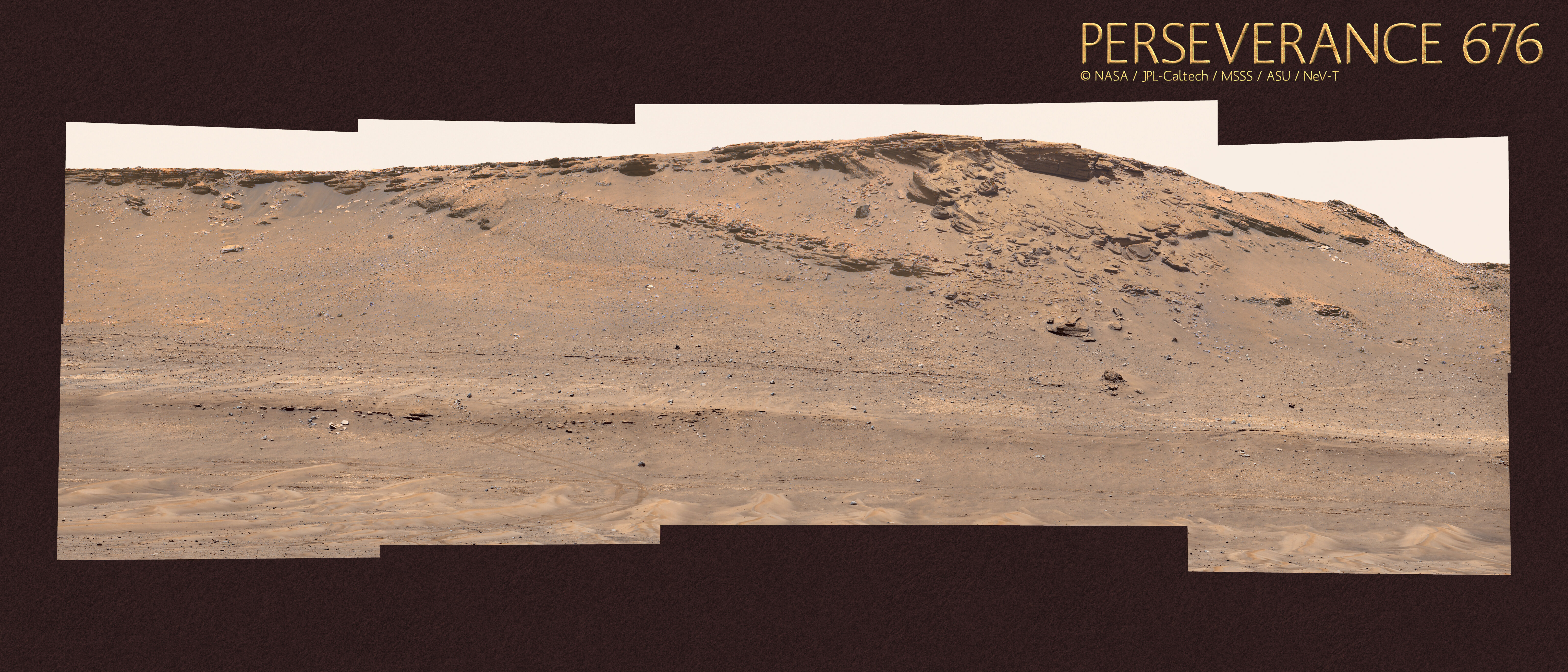
The actual tilt of Mastcam-Z around the optical axis with respect to the horizon on the left side of Neville's panorama was about 4° clockwise,
while this part of the panorama is slightly tilted about 2° counterclockwise. Therefore, this part should be rotated 6° clockwise.
Additionally, there is a perspectivic effect. The top of the cliff is 60 m higher than the rover position. The distance to the rover is about 180 m.
The cliff edge is on its left side farther away from the rover, which reduces the apparent height there due to perspective and results in an
additional apparent tilt of the cliff edge to the left by a few degrees. Therefore, the cliff will look more like the image below,
where the apparent tilt is reduced, and only a slight apparent dip of the layers above the erosional unconformity to the left remains.
The elevation map shows that the top of the cliff is quite flat within a few meters.
Click to view attachmentClick to view attachment
scalbers
Sol 700 panorama, along with a large version derived from Paul's tiled NavCams and pointing info.

Click to view attachment

Sol 702 panorama, along with a large version.

Click to view attachment

We can watch the changing landscape in this extended drive animation from Sol 394 to the present.
serpens
Thanks Tau. I hadn't considered panorama tilt and thought the lower ridge provided a reasonable horizontal reference. But even with that correction I still see a rising gradient in the topset to foreset rollover points, evident in localised segments to preclude perspective errors. For example under the round basaltic boulder in the centre of your image. Probably another correction lurking but there is evidence of faulting with potential for localised tilting due to compression.
scalbers
Tau's topo map really helps to get oriented with this part of the Franklin Cliffs. The overall perspective (changing from a flat to tilted appearance) is evident in the drive animation I linked to when viewing from Sol 646 up to the present (post #629). Another pair that shows this is when stepping between Sols 535 and 536.

Click to view attachment
tau
Trying to catch up with the wealth of incoming raw images, here is a sol 704 SuperCam Remote Micro-Imager mosaic with a Navcam context image

Click to view attachmentClick to view attachment
tau
Sol 702 Mastcam-Z left eye filter 0 raw image (black frame omitted), and left eye filters 1 to 6 (visible to nearest infrared light) multispectral principal components.
The surface of the rock shows color zoning and an arc-shaped remnant of purple coating.

Click to view attachmentClick to view attachment
tau
Sol 701 SuperCam Remote Micro-Imager mosaic with Navcam context

Click to view attachmentClick to view attachment
tau
Sol 697 Mastcam-Z left eye filter 0 raw image (black frame omitted) and left eye filters 1 to 6 (visible to nearest infrared light) multispectral principal components.

Click to view attachmentClick to view attachment
Phil Stooke
This is from Steve's panorama for sol 700. Some parts were patched using parts of Paul's original frames. It's a good combination of skills.

Phil

Click to view attachment

Click to view attachment
neo56
The very large mosaic taken on sol 693 at Three Forks, with the position of the 10 sample tubes.
Also on Gigapan.

Phil Stooke
Steve's panorama for sol 702 in circular form.

Phil

Click to view attachment

Click to view attachment
tau
Sol 704 SuperCam Remote Micro-Imager mosaic, slightly rotated and heavily jpeg-compressed to meet upload limits

Click to view attachment
tau
Sol 704 Mastcam-Z mosaic with enhanced colors, marsonaut for scale, and contour of the SuperCam RMI mosaic in the previous post

Click to view attachment
neville thompson

Gigapan - PERSEVERANCE 704
© NASA/JPL-Caltech/MSSS/ASU/NeV-T

scalbers
Sol 707 panorama, along with a large version derived from Paul's tiled NavCams and pointing info.

Click to view attachment
scalbers
Moving well ahead with this Sol 708 panorama, along with a large version derived from Paul's tiled NavCams and pointing info.

Click to view attachment

Sol 709 panorama and large version.

Click to view attachment

We can watch the changing landscape in this extended drive animation from Sol 394 to the present.
Phil Stooke
Thanks, Steve. This is the sol 707 panorama in circular form. The steep slope introduces unavoidable distortions.

Phil

Click to view attachment

Click to view attachment
Phil Stooke
And the same for sol 708.

Phil

Click to view attachment

Click to view attachment
tau
Sol 706 SuperCam Remote Micro-Imager mosaic with Mastcam-Z context,
a Mastcam-Z image with enhanced colors showing remnants of purple coating, and an anaglyph

Click to view attachmentClick to view attachmentClick to view attachmentClick to view attachment
tau
Sol 707 SuperCam Remote Micro-Imager mosaic with Mastcam-Z context,
and Mastcam-Z left eye filters 1 to 6 (visible to nearest infrared light) multispectral principal components

Click to view attachmentClick to view attachmentClick to view attachment
Phil Stooke
This is Steve's panorama for sol 709 in circular form. The surface is more level so the relief distortion is less severe.

Phil

Click to view attachment

Click to view attachment
scalbers
Looks good Phil - it's interesting to follow the changes in perspective view of the smaller rocky escarpments off to the southwest between Sols 707, 708, and 709.
PDP8E
SOL 709 -- 3:43pm -- Jezero Crater
DeepHisto -- two right nav images
Click to view attachment
This is a "lo-fi" version of our main content. To view the full version with more information, formatting and images, please click here.
Invision Power Board © 2001-2024 Invision Power Services, Inc.