https://mars.nasa.gov/mars2020-raw-images/p..._095J02_800.jpg
A brand new sample on sol 490!
Phil
Full Version: Jezero Delta Campaign, Sols 414-1000


We're just seeing a gap between the rocks, as you can see from stereo views. Anaglyph:
Click to view attachment
Cross-eyed:
Click to view attachment
Click to view attachment
Cross-eyed:
Click to view attachment
1. The sol 482 abrasion patch in a combination of enhanced colors from SHERLOC WATSON camera (sol 485) and higher-resolution details from SHERLOC ACI (sol 489).
2. The context of 1. in the SHERLOC WATSON camera raw image.
3. One of the SHERLOC Autofocus and Context Imager (ACI) raw images used for the focus stack.
Note: The faintly visible regular pattern of small circles is not a property of the Martian rock,
but presumably an effect of SHERLOC's ultraviolet laser used for Raman and fluorescence spectroscopy.
Click to view attachment Click to view attachment Click to view attachment
Yes indeed it is a gap, though I wonder about the bowling pin shaped feature within.
QUOTE (fredk @ Jul 10 2022, 06:46 PM) 
We're just seeing a gap between the rocks, as you can see from stereo views.
QUOTE (scalbers @ Jul 10 2022, 01:45 PM)
Yes indeed it is a gap, though I wonder about the bowling pin shaped feature within.
Isn't it just a rock on top of another rock?
Or two small, adjacent rocks. Nice image though.
Yes would be interesting if it's possible to see the context of the rocks later on. The lighting regime is different from the foreground and one might guess where the more distant horizon is placed.
The 1st sedimentary core has been named 'Swift Run'
https://mars.nasa.gov/mars-rock-samples/
Click to view attachment
https://mars.nasa.gov/mars-rock-samples/
Click to view attachment
QUOTE (tau @ Jul 10 2022, 02:34 PM)
1. The sol 482 abrasion patch in a combination of enhanced colors from SHERLOC WATSON camera (sol 485) and higher-resolution details from SHERLOC ACI (sol 489).
2. The context of 1. in the SHERLOC WATSON camera raw image.
3. One of the SHERLOC Autofocus and Context Imager (ACI) raw images used for the focus stack.
Note: The faintly visible regular pattern of small circles is not a property of the Martian rock,
but presumably an effect of SHERLOC's ultraviolet laser used for Raman and fluorescence spectroscopy.
1 Click to view attachment . . 2 Click to view attachment . . 3 Click to view attachment
And as seen in weathered outcrop, it has an unsorted, poured-in look.
Regarding the quoted post #256:
There seems to be a glitch in UMSF's content management system.
Originally I had the thumbnails and their numbers arranged in a horizontal row, and they were displayed that way after upload.
Now they are suddenly arranged in a vertical column, with a line break before each thumbnail, resulting in irritating numbering (see the quote in post #262 above).
Presumably this effect is triggered when a post is quoted.
This vertical arrangement of the thumbnails can be undone in the edit preview, but not in the uploaded post, so I removed the numbers in post #256.
Can anyone give a hint on how to avoid this effect?
QUOTE (Bill Harris @ Jul 12 2022, 02:17 AM)
And as seen in weathered outcrop, it has an unsorted, poured-in look.
I'm a bit lost as to the depositional environment we are looking at with Oventop Mountain. I assume deltaic and poor sorting is common to foresets and bottom sets with slumps, sediment gravity flow and turbidity currents. But Oventop Mountain seems to lack any sizeable clasts, nothing more than sand and granules under the Wentworth scale. So I would hesitate to term it poorly sorted and posit it being the result of sorting with the delta slope fining downwards to pro delta.
QUOTE (serpens @ Jul 12 2022, 02:18 PM)
I'm a bit lost as to the depositional environment we are looking at with Oventop Mountain. I assume deltaic and poor sorting is common to foresets and bottom sets with slumps, sediment gravity flow and turbidity currents. But Oventop Mountain seems to lack any sizeable clasts, nothing more than sand and granules under the Wentworth scale. So I would hesitate to term it poorly sorted and posit it being the result of sorting with the delta slope fining downwards to pro delta.
Curious- having seen how some 'flashy' streams will dam the creeks they flow into, until the creek overtops the debris, and also seeing this in estuaries on Earth where sand dunes block a large slow estuary or river:
Could Martian dunes moving block and backup braided channels / estuaries with the eventual overtopping sluicing away well sorted sand as turbidity currents?
The second core has been extracted from the 'Skinner Ridge' rock seen in this NavCam tile from sol 495
Also what appears to be some EDL debris? captured in this HazCam tile from just in front of 'Skinner Ridge' on the same sol. Note: It was not in that location on sol 491.
Click to view attachment Click to view attachment
Also what appears to be some EDL debris? captured in this HazCam tile from just in front of 'Skinner Ridge' on the same sol. Note: It was not in that location on sol 491.
Click to view attachment Click to view attachment
From your post #240 and link Paul, I thought this rock exposure was called Oventop Mountain?
The previous name is the rock, the new name is for the sample. The second core will get another name.
Phil
Phil
QUOTE (serpens @ Jul 13 2022, 02:15 PM)
From your post #240 and link Paul, I thought this rock exposure was called Oventop Mountain?
It was referred to as Oventop mountain in one report, but looks like it may have changed, or someone slipped up.
Here is the JPL log of sample names, it does not include the latest sample yet, but you can see they now call the rock 'Skinner Ridge', the first core at Skinner Ridge was called 'Swift Run'
https://mars.nasa.gov/mars-rock-samples/
Click to view attachment
QUOTE (PaulH51 @ Jul 13 2022, 03:08 AM)
Also what appears to be some EDL debris
In stereo - anaglyph:
Click to view attachment
Cross-eyed:
Click to view attachment
Give a hoot - don't pollute? Keep Mars tidy?

The second sedimentary core from 'Skinner Ridge' has been called 'Skyland' has been added to the mission samples page. A little shorter than 'Swift Run' at just 5.85cm 
Click to view attachment
URL for the samples page
Click to view attachment
URL for the samples page
Sol 497 SuperCam Remote Micro-Imager mosaic with Mastcam-Z context and anaglyph
Click to view attachment Click to view attachment Click to view attachment
Click to view attachment Click to view attachment Click to view attachment
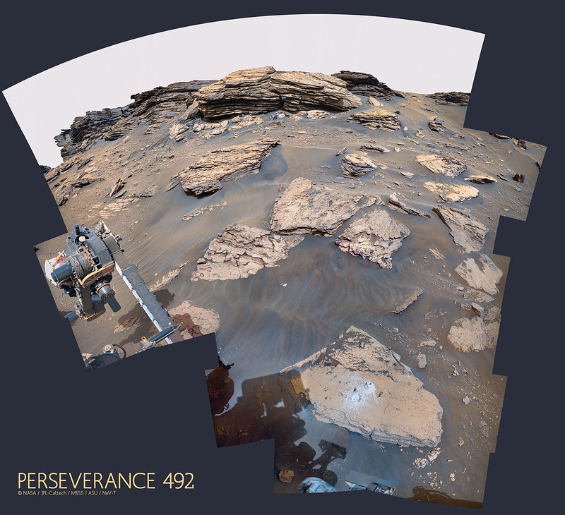
Sol 497 SuperCam Remote Micro-Imager mosaic no. 2 with sol 492 Mastcam-Z context
and sol 489 Mastcam-Z left eye multispectral filters 1 to 6 principal components
Click to view attachment Click to view attachment Click to view attachment
and sol 489 Mastcam-Z left eye multispectral filters 1 to 6 principal components
Click to view attachment Click to view attachment Click to view attachment
Apologies...
Posted to wrong thread.
Admin please remove post
TIA
Posted to wrong thread.
Admin please remove post
TIA
oops! Wrong rover...
Phil
Phil
QUOTE (PaulH51 @ Jul 16 2022, 03:26 AM)
I prefer to call it "The Sorting Hat" in place of the coprolite banter on social media
Click to view attachment
Credit to Fredk for his Bayer reconstructed frames
Click to view attachment
Credit to Fredk for his Bayer reconstructed frames
Meh, better described as Hersey kiss on a brownie.
So much for the S:N ratio.
I recently posted an image showing the abrasion and drill holes at Skinner Ridge, and it seemed like a good idea to do this for other sampling sites as well. This is the previous sample site at Sid:
Click to view attachment
For some reason the second drill hole at Atsah was not documented in images before we drove away.
Phil
Click to view attachment
For some reason the second drill hole at Atsah was not documented in images before we drove away.
Phil
QUOTE (tau @ Jul 15 2022, 04:16 AM)
Sol 497 SuperCam Remote Micro-Imager mosaic no. 2 with sol 492 Mastcam-Z context
and sol 489 Mastcam-Z left eye multispectral filters 1 to 6 principal components
and sol 489 Mastcam-Z left eye multispectral filters 1 to 6 principal components
I love this view because we see lamination-scale sedimentary structures very well. Although this view shows seemingly boring, horizontal centimeter-scale units, the close (zoom in!) view gives some important details:
1) the structure is visible due to differential weathering on a fracture (probably a joint formed during exhumation), probably controlled by varied degrees of cementation
2) the centimeter-scale units seem to be fining- and better-sorted-upward, probably graded, couplets
3) although dominantly horizontal and planar parallel, the finer tops of some of the couplets are capped by an erosion surface about half of a couplet in amplitude (this is how we can say which is the top or bottom of the couplet), and they are distinctly wavey in profile
4) there is an overall fining-upward trend in the view
My interpretation would be that this is the deposit of a single, waning, but pulsing, sediment-gravity flow. The couplets are a record of the passage and aggradation of individual traction carpets, with bypass and erosion between. This facies is not inconsistent with deposition on a the outer mouth bar or front of a delta. The traction carpets could have been part of an expanding sheet-like flow, or associated with larger bedforms like antidunes or cyclic steps.
Not sure if this helps or hurts the S:N, Bill!
Tim, it helps the S:N !
Drive during Sol 501: 19.4m ~Southwest, but still on the Bacon strip.
2x2 tiled NavCam and extracts from the JSON data.
Click to view attachment Click to view attachment
2x2 tiled NavCam and extracts from the JSON data.
Click to view attachment Click to view attachment
Here is a circular view of the sol 501 position from a full set of Paul's images. There is another small move on sol 502.
Phil
Click to view attachment
Phil
Click to view attachment
Another small debris spotted Sol 484, while building a panoramic picture.
It has a more 'bluish' color when compared to other small rocks nearby.
Enjoy
Processed picture:
Click to view attachment
Weblink to the raw image:
https://mars.nasa.gov/mars2020/multimedia/r...AM08513_0340LMJ
It has a more 'bluish' color when compared to other small rocks nearby.
Enjoy
Processed picture:
Click to view attachment
Weblink to the raw image:
https://mars.nasa.gov/mars2020/multimedia/r...AM08513_0340LMJ
Sol 504: The latest 5cm dia. abrasion patch on Mars.
Located on a rock called 'Wildcat Ridge' in the Hogwallow Flats area.
This time the fine-grained rocks of the Bacon Strip have not fragmented during abrasion.
Looks like there maybe be an existing fracture and what looks like a light toned fracture fill (more fun for the science team)
Source for the rock name: https://sketchfab.com/3d-models/m2020-zcam-...8f7103eff79987a
Click to view attachment Click to view attachment
This circular view of the current location was made from Paul's sol 502 images.
The full panorama contains five full Navcam frames, pointing low, and 3 or (in this case) 4 partial frames extending it up to the horizon. Combining them is time-consuming (even with Paul's much appreciated help making the composites from smaller tiles). The whole process would be easier if the five frame pan was aimed high to get the horizon and the bottom was filled in with partial frames (covering mainly the workspace). I suppose there is a reason for doing it the other way - better stereo of the workspace, most likely.
Phil
Click to view attachment
Sol 507 LMastcam-Z:
Click to view attachment
Another view on sol 507 (LMastcam-Z):
Click to view attachment
Click to view attachment
Another view on sol 507 (LMastcam-Z):
Click to view attachment
1. The sol 504 abrasion patch in a combination of enhanced colors from SHERLOC WATSON camera (sol 504) and higher-resolution details from SHERLOC ACI (sol 505).
The largest grain size is about 120 µm (light grains). The diameters of small grains are hardly discernible, but they are definitely smaller than 40 µm. Black dots are presumably pores.
2. The context of 1. in the SHERLOC WATSON camera raw image.
3. A wider context in a sol 504 Navcam image
Click to view attachment Click to view attachment Click to view attachment
Links to raw images:
SHERLOC Autofocus and Context Imager (ACI) (one out of five images)
SHERLOC WATSON camera
Navcam
Sol 505 SuperCam Remote Micro-Imager mosaic with sol 505 Mastcam-Z context and sol 502 Navcam context
Click to view attachment Click to view attachment Click to view attachment
Click to view attachment Click to view attachment Click to view attachment
QUOTE (tau @ Jul 25 2022, 07:55 PM)
Sol 505 SuperCam Remote Micro-Imager mosaic with sol 505 Mastcam-Z context and sol 502 Navcam context

Curious- now that we're seeing such fine layers, what is the rover's accuracy to sample one specific layer?
I know you'd get better arc-minute resolution as you get closer, but I never thought whether the sample line can be selected for spacing and for angle e.g. level versus 10º slope vs 45º slope.

QUOTE (charborob @ Jul 25 2022, 07:29 PM)
Sol 507 LMastcam-Z:
What a wonderful outcrop, the sedimentary log practically writes itself especially in this section here. I think there are two facies here, the tan-coloured erosion-succeptible laminated facies (siltstone?) and the blue-grey tabular erosion-resistant thick beds (sandstone?). In the bottom half of the exposed stratigraphy the tan facies dominates, but this reverses in the top half where thick blue-grey beds dominate. If these tabular sandstone beds were deposited on the delta slope in turbidite events, then perhaps the transition here marks the arrival of a prograding delta ontop of bottomset muds.
Click to view attachment

Another sedimentary rock core acquired, processed and sealed on Sol 509
Click to view attachment Click to view attachment Click to view attachment Click to view attachment
Click to view attachment Click to view attachment Click to view attachment Click to view attachment
That does look like scour fill.
QUOTE (Saturns Moon Titan @ Jul 26 2022, 04:26 PM)
What a wonderful outcrop, the sedimentary log practically writes itself especially in this section here. I think there are two facies here, the tan-coloured erosion-succeptible laminated facies (siltstone?) and the blue-grey tabular erosion-resistant thick beds (sandstone?). In the bottom half of the exposed stratigraphy the tan facies dominates, but this reverses in the top half where thick blue-grey beds dominate. If these tabular sandstone beds were deposited on the delta slope in turbidite events, then perhaps the transition here marks the arrival of a prograding delta ontop of bottomset muds.
I would interpret this outcrop as a succession of coarsening- and thickening-upward sandstone units, characterized by low-angle inclined lamination and truncations. Close-ups of the bedding and lamination show that the units are made up of fining-upward, cm-scale, coarse/fine couplets. Some of the erosional truncations are broad, meter-scale, and remove decimeters of underlying strata, while others are more localized, with steeper margins.
My interpretation would be that this succession was deposited by supercritical sediment gravity flows (turbidity currents and/or hyperpyncnal flows) that formed large-scale, migrating and aggrading bedforms, like antidunes and cyclic steps, on the delta front and outer part of the stream mouthbar. The geometry of the truncations is more indicative of scour in the trough of crescentic or sinuous-crested bedforms or bedform trains rather than channel incision.
I studied deposits like this in the Eocene of the Catalan Coastal Range in Spain:
Reconstruction of bedform dynamics controlled by supercritical flow in the channel-lobe transition zone of a deep-water delta (Sant Llorenç del Munt, NE Spain, Eocene)
I was inspired when working on these deposits by work done on the modern Squamish River delta in British Columbia, nicely detailed in this recent paper:
Daily bathymetric surveys document how stratigraphy is built and its extreme incompleteness in submarine channels
My biggest uncertainty in this interpretation is whether there are backset (indicating up-flow accretion rather than down-flow from foresets) strata, which would only be discernible in outcrops that show the strata in a depostional dip sense...I think these particular outcrops are more of a depositional strike view. Looking forward to getting 'round the corner!
QUOTE (serpens @ Jul 27 2022, 12:44 AM)
That does look like scour fill.
I agree, but the "stuff" in the scour is curious...
I think this "stuff" might be an outsized, reworked clast, transported from somewhere in the drainage basin, in its final resting place in the delta front deposits. Outsized clasts like this can move surprisingly long distances by getting scoured around and then flipping, flopping and rolling in flows that otherwise don't have the competence to move them. I've seen big clasts like this far out on supercritical lobes in fan deltas, and they typically sit, proudly, in the final scoured pit where they stopped. The geometry of the scour (quite localized), and the fill (onlapping and flattening-upward) support this interpretation. There is even a much smaller scour just above this one, that looks like it was generated by a current shadow around the clast before is was completely buried by subsequent flows.
Sol 507 Mastcam-Z anaglyph:
Click to view attachment
Click to view attachment
To get across the delta and be able to start assembling these wonderful outcrop views into a larger picture. There are going to be complex and dynamic ptocesses at work here. I'm waiting to get higher in the section and in altitude to see subaerial landforms of the delta top.
--Bill
--Bill
This is a "lo-fi" version of our main content. To view the full version with more information, formatting and images, please click here.