Malmer, by "depth cues" do you mean that you selectively inserted some kind of haze effects in proportion to how far away the features might be?
Or is that haze information naturally present in the downloaded data?
Either way, it certainly helps the mind to organize what the eyes are seeing.
It's reminiscent of something you might see underwater when the sea is rough enough to kick up some silt.
If I were snorkeling I'd want to get out of there quickly.
Full Version: Philae landing on the nucleus of Comet 67P C-G
Pages: 1, 2, 3, 4, 5, 6, 7, 8, 9, 10, 11, 12, 13, 14, 15, 16, 17, 18, 19, 20, 21, 22, 23, 24, 25, 26, 27, 28, 29
That is a great pic, Malmer, it has a cool effect like Philae is exploring underwater! Is the depth cue the only difference from the original? It seems like it is more colorful but I'm wondering if that is just an illusion from the overlaid blue-gray depth shade.
I've also been playing around with simulating Philae's trajectory after the initial touchdown. Although we have an estimate of the final position from the CONSERT analysis, I wanted to get an idea of the actual bounce trajectory (at least the first one).
Gravity is computed using a set of point masses (similar to Malmer's previous simulation) whose total mass equals that reported for 67P-C/G. Rosetta orbits match very well but I won't know how accurate the gravity model is at close range until testing with greater point density until seeing convergence.
The initial conditions are chosen carefully by inspecting the 3D model and the images showing the initial touchdown location, as well as using Siman's analysis from post #757 to define the apparent ground-track speed. The initial velocity is perturbed with varying azimuth and elevation angle but fixing the ground-track speed (ie. change the apparent direction and add some vertical speed).
After much consideration, I concluded that the comet rotation can be assumed to be the z-axis of the 3D model coordinate system (I still need to check how this compares with what Joe talked about in post #856, but it does look close). Velocity components due to the comet rotation are then added so that the simulation can be performed in the inertial frame.
Simulation then simply runs until Philae collides with the model (ie. only the first bounce). We know the duration of the bounce, so I wanted to get an idea of what range of initial conditions results in that duration for the flight. Therefore, I actually simulate using a genetic algorithm where the fitness function is the flight duration.
Attached are some initial results showing the offspring trajectories after three generations. The red lines are the flight paths and the white lines are the paths projected onto the ground. Overlaid in yellow is roughly where it appears the CONSERT data estimates the landing site, suggesting I should shift the initial search space appropriately.
The depth cues are NOT in the actual data. I manually (and rather crudely) segmented the image boulder for boulder. I looked for sillhouettes and overlaps. That gave an initial depth sorting. Then i just looked at shadows and the size of the surface graininess to try to judge relative distances. I used the old "till it looks right" method. One could possibly do some kind of frequency analysis and get better relative distance estimates.
I then coloured the surface reddish (like that color comet pic) and then just decreased the contrast over distance (mostly in blue) to create a fog effect.
(I hate writing on the iphone. I always slip one letter to the left on the keyboard. Every time i try for an "m" i get an "n")
I then coloured the surface reddish (like that color comet pic) and then just decreased the contrast over distance (mostly in blue) to create a fog effect.
(I hate writing on the iphone. I always slip one letter to the left on the keyboard. Every time i try for an "m" i get an "n")
Brian. My gravity was way off. Byt we have sortof the same direction going for us. I wonder what we are doing wrong...
Malmer, great depth analysis. It's qualitative rather than quantitative but I think it's real. Depending on orientation we can be looking down from up the cliff or more horizontally across the cliff face.
I've taken a step away from the panorama and concentrated on the solar panel data.
Here's the data projected into a 360x180 pan.
The blue boxes are the rough areas "covered" by each solar panel. Assuming that panel 2 points to the west.
Also assuming horizontal orientation.
The gray scale inset is the reported illumination times / strengths. Using the sunset as the "leftmost" limit here, since we know that light can't come from the south.
The gray line is my proposed horizon line. Tried to match illumination and to draw something that would generate shadows, and limit light to just 2 or 3 panels at the same time.
Of course, in reality the panels aren't perfectly horizontal. As i have it, the landscape does seem to be tilted from the bottom left to the top right.
That is consistent with panel 2 being somewhat turned upwards. I'm not trying to correct that, since it will induce even more uncertainties.
Click to view attachment
I think this helps to pin down the CIVA pan. You have two points: free space to the west (with some notion of the size of the "opening") and the sun position.
Brian, your simulation is very interesting, very nice and very promising. I think that you can quietly adjust the direction of the initial vector, because we do not know it well enough. I suppose that impact points then can be very close to the yellow area from the CONSERT measurements.
How high are the jumps? From the picture I estimate less than 500 meters, which would be consistent with my expectations.
How high are the jumps? From the picture I estimate less than 500 meters, which would be consistent with my expectations.
QUOTE (Brian Lynch @ Nov 26 2014, 03:31 AM) 
After much consideration, I concluded that the comet rotation can be assumed to be the z-axis of the 3D model coordinate system
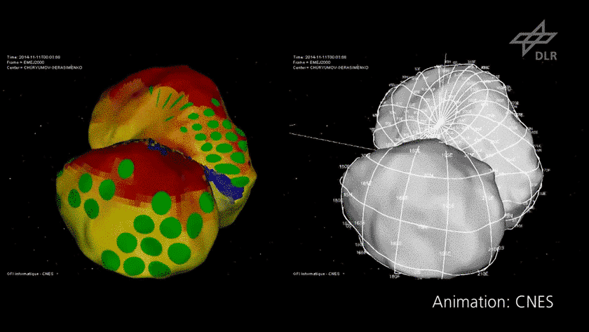
It's a fair bit of work (par for the course around these parts!) but I'm thinking a way to pin down the relation of the comet axes to the shape models (ESA's and Mattias's) is to use SPICE data to reconstruct the viewing geometry from published OSIRIS shots with timestamps, and then fiddle with the alignment until the result matches (by eyeball) the published image. Haven't gotten there yet (I can only take spherical geometry in limited doses), but at least have the SPICE part down. Of academic interest, here's a video of the view from the OSIRIS camera as Philae descended to the nominal touchdown point (no bounce) with the comet shown schematically as an ellipsoid:
https://www.youtube.com/watch?v=xRITrrh_y8o
SPICE shows the camera pointing but doesn't say when images were taken, but the above matches up well with some OSIRIS images that have been published.
QUOTE (scalbers @ Nov 25 2014, 02:06 PM)
I believe things are different when we consider the sun's high declination of +37 degrees. The diurnal track stays in the northern sky the entire day, even if we are on the equator. Max solar altitude is 53 degrees.
That's interesting--if there's a cliff/wall to the north then that might explain a lot of shadowing, but the light situation could change dramatically as the sun moves to more southerly declinations.
Reviewed my lastest solar panel panorama with a more conservative horizon profile (dashed line). Tried to constrain the illumination pattern to just 2 panels at each given time, including the top one.
Yes, assuming an horizontal orientation the surface extends up to the north causing large shadows.
Click to view attachment
Yes, assuming an horizontal orientation the surface extends up to the north causing large shadows.
Click to view attachment
Malmer's 'Depth Cue' image inspired me to make it into a faux anaglyph.
QUOTE (jmknapp @ Nov 26 2014, 11:11 AM)
It's a fair bit of work (par for the course around these parts!) but I'm thinking a way to pin down the relation of the comet axes to the shape models (ESA's and Mattias's) is to use SPICE data to reconstruct the viewing geometry from published OSIRIS shots with timestamps, and then fiddle with the alignment until the result matches (by eyeball) the published image. Haven't gotten there yet (I can only take spherical geometry in limited doses), but at least have the SPICE part down. Of academic interest, here's a video of the view from the OSIRIS camera as Philae descended to the nominal touchdown point (no bounce) with the comet shown schematically as an ellipsoid:
https://www.youtube.com/watch?v=xRITrrh_y8o
SPICE shows the camera pointing but doesn't say when images were taken, but the above matches up well with some OSIRIS images that have been published.
https://www.youtube.com/watch?v=xRITrrh_y8o
SPICE shows the camera pointing but doesn't say when images were taken, but the above matches up well with some OSIRIS images that have been published.
I have pretty much all the navcams/OSIRIS frames viewing geometry reverse engineered. so you should be able to use my cameras to constrain it all...
I got an email today from pending UMSF user: "Deepnet"
He had found this very interesting info:
This might help position the CIVA images in time ?
In a BBC interview , referring to the 1st CIVA surface image release Andrea Accomazzo says :
"We received the image 20 minutes ago and it was taken about an hour ago"
The UTC clock behind him reads 317 07:20:22
The interview is at ~37:00 in the BBC Sky at Night Special, the
interviewer is Chris Lintott.
http://www.bbc.co.uk/iplayer/episode/b04pk...t-night-special
The screen then cuts to the attached screenshot which shows
Lander Elevation 157.06
Lander Rotation 11.01
That is interesting info. Do you think it can be used or is it too vague? when he says "one hour ago" he is probably off by a little bit of time. lets say half an hour or so. That's 15 degrees of comet rotation... Not so bad.
QUOTE (4th rock from the sun @ Nov 26 2014, 06:14 AM)
Reviewed my lastest solar panel panorama with a more conservative horizon profile (dashed line). Tried to constrain the illumination pattern to just 2 panels at each given time, including the top one.
Yes, assuming an horizontal orientation the surface extends up to the north causing large shadows.
Click to view attachment
Yes, assuming an horizontal orientation the surface extends up to the north causing large shadows.
Click to view attachment
Interesting, but it does seem to contradict the implied NWish direction for panel 2 given in the reddit discussion. Could they have meant SWish instead? Of course it really depends on what he meant by "facing", I interpenetrated that as panel 2 but he could have meant panel 3 if they consider that the "front" of the lander which would actually match your modeling.
QUOTE (Malmer @ Nov 26 2014, 08:14 AM)
Lander Elevation 157.06
Lander Rotation 11.01
Lander Rotation 11.01
From the screen grab (attached) it looks like that info has a timestamp of 2014.317.06.12.52.208--Nov. 13 at 06:12UT? But what does elevation of 157.06 (units?) mean?
Click to view attachment
I think that's due to error associated with the shape model (in meters)
QUOTE (jmknapp @ Nov 26 2014, 01:53 PM)
But what does elevation of 157.06 (units?) mean?
Just a guess: elevation and rotation related to the landing legs.
___________
This is the reference I'm using for solar panel numbering. Not sure where I got it, I think it was posted on reddit ...
Click to view attachment
So from the left to right, you have panels 1 to 5. Panel 6 is at top. One side of the lander has no panel at all.
I corrected the panel coverage on my pan to better represent the different panel sizes. Fits well with the fact that they rotated panel 1 (the "large panel" as they referred to it) to face the clear W-NW direction.
Click to view attachment
QUOTE (chemman @ Nov 26 2014, 08:57 AM)
I think that's due to error associated with the shape model (in meters)
What if it means the final location is 157 meters above the expected landing spot?(clueless guess)
edit: Maybe stacking multiple screen grabs will make the units for the 157 more clear?
QUOTE (jmknapp @ Nov 26 2014, 02:53 PM)
From the screen grab (attached) it looks like that info has a timestamp of 2014.317.06.12.52.208--Nov. 13 at 06:12UT? But what does elevation of 157.06 (units?) mean?
I bet it says "mm" as units for elevation. That must be how high the body is lifted from the landing legs. 15 cm sounds about right don't you think...
The 11.1 degrees are consistent with the way the legs are rotated in relation to the body aswell.
When I quickly hand matched the landers legs to the images I got a value of about 10 degrees... So that must be it.
Short reminder: http://www.reddit.com/r/IAmA/comments/2nhh...ers_working_on/ Reddit AmA starts in 10min. The following persons are there to answer the questions:
Michael F. A'Hearn - Astronomy Professor (emeritus) and Principal Investigator of the Deep Impact mission (ma)
Claudia Faber - Rosetta SESAME Team, DLR-PF/Berlin (cf)
Stubbe Hviid - Co-Investigator of the OSIRIS camera on Rosetta at DLR-PF/Berlin (sh)
Horst Uwe Keller - Comet Scientist (emeritus), DLR-PF/Berlin and IGEP TU Braunschweig (uk)
Martin Knapmeyer - Co-Investigator of the SESAME Experiment at DLR-PF Berlin (mk)
Ekkehard Kührt - Science Manager for Rosetta at DLR-PF/Berlin (ek)
Michael Maibaum - Philae System Engineer and Deputy Operations Manager at DLR/Cologne (mm)
Ivanka Pelivan - MUPUS Co-Investigator and ROLIS team member (operations) at DLR-PF/Berlin (ip)
Stephan Ulamec - Manager of the Philae Lander project at DLR/Cologne (su)
QUOTE (Malmer @ Nov 26 2014, 10:35 AM)
I bet it says "mm" as units for elevation. That must be how high the body is lifted from the landing legs. 15 cm sounds about right don't you think...
Better than my guess!Maybe the 15cm is how high the lift manouver raised the body.
From reddit:
"We just triple-landed a robot lab on a comet. Ask us Anything!"
 That's confidence!
"We just triple-landed a robot lab on a comet. Ask us Anything!"
That's confidence! QUOTE (Malmer @ Nov 26 2014, 10:35 AM)
I bet it says "mm" as units for elevation. That must be how high the body is lifted from the landing legs. 15 cm sounds about right don't you think...
The 11.1 degrees are consistent with the way the legs are rotated in relation to the body aswell.
When I quickly hand matched the landers legs to the images I got a value of about 10 degrees... So that must be it.
The 11.1 degrees are consistent with the way the legs are rotated in relation to the body aswell.
When I quickly hand matched the landers legs to the images I got a value of about 10 degrees... So that must be it.
See Emily's blog post here http://www.planetary.org/blogs/emily-lakda...lae-during.html referencing the spice navigational data for the 158m altitude at touchdown. Which refences jmknapps post #711. The screen shot actually shows the units with elevation in "m" and rotation in "grad"s
Joe's descent.txt from SPICE says 0.165 km; one more hint, that the unit "meter" (above ground) appears to be correct.
So does the "lander rotation" value give us the rotation of the lander during descent? It's given in gradians where 1 grad = 0.9deg, so 11.01grad = 9.91deg. If we assume there an implied time component of /mins then that's 9.9 deg/min rotation.
Edit- but the time stamp looks to be on Nov 13th hmmm.
Edit- but the time stamp looks to be on Nov 13th hmmm.
317. day in the year. So, what was apparent Sun position on 13. Nov 2014. 06.20.22 UTC at the suspected final landing location?
Axis of rotation and accepted local coordinate system:
Axis of rotation and accepted local coordinate system:
I'd like to see a "ground truth" for that coordinate system, like the lat/lon of the intended touchdown point. The video above seems pretty clear--clearer on the youtube link: https://www.youtube.com/watch?v=CNGu7KbXzOs but according to that the 0 degree longitude meridian is on the larger lobe. But the touchdown location per SPICE is 12N 24W, so that would place the 0 longitude meridian on the smaller lobe. So either there's a discrepancy between how SPICE and CNES define the meridian (it's arbitrary, right?) or I have a bug.
As for the elevation noted in the screen grab, would it make sense that they would know Philae's elevation above the datum or whatever on Nov. 13? They still don't know exactly where the lander is, so that seems unlikely. So maybe it is something like the elevation in mm above the lander's legs as Mattias suggested, i.e., something the lander wold know locally.
BTW, I saw in the reddit that Mattias asked about the timestamps of the CIVA panorama, but didn't get an answer, other than that they have them (well duh). As No. 2 on The Prisoner would say, "That would be telling."
I feel like I'm out of the loop, can someone post the transformation between the 3D model from ESA and this accepted rotation and orientation? The z-axis in the model coordinate system does look like it aligns with the spin axis but I'd prefer to use the currently established values. Is it possible to get a rotation matrix (or quaternion, or roll-pitch-yaw)? Also, are we all assuming the CG is at the 3D model frame origin?
I think the unit is clearly not "m" by comparison with other "m"s (circled):
Click to view attachment
My best guess is mm.
(Joe: careful, or the big beach balls will get you... )
Click to view attachment
My best guess is mm.
(Joe: careful, or the big beach balls will get you...
)
mm made sense to me, but what about [m], in brackets for whatever reason?
Could elevation, but not location, of final landing be judged from transmission times on communication passes? But in that case, the ".06" could not be significant. If measuring mm, .06 would also be a very fine measure of mechanical position.
Could elevation, but not location, of final landing be judged from transmission times on communication passes? But in that case, the ".06" could not be significant. If measuring mm, .06 would also be a very fine measure of mechanical position.
This AGU abstract:
https://agu.confex.com/agu/fm14/meetingapp.cgi#Paper/12394
includes a small map. It shows that Philae's intended touchdown point was close to 0 latitude, 180 longitude.
Phil
https://agu.confex.com/agu/fm14/meetingapp.cgi#Paper/12394
includes a small map. It shows that Philae's intended touchdown point was close to 0 latitude, 180 longitude.
Phil
QUOTE (sittingduck @ Nov 26 2014, 12:05 PM)
Malmer's 'Depth Cue' image inspired me to make it into a faux anaglyph.
About these cool efforts to add a sense of depth: If you look at the original two-frame (high resolution) mosaic, the regions Malmer identified as farther are darker. I find this intriguing. The darker surfaces could have lower albedo, though it would be perhaps an odd coincidence that albedo was correlated with distance from where the lander happened to set down.
More likely is a phase angle effect, ie we're seeing more tiny shadows in the darker regions. In this case there's no reason to expect darker regions should be farther away (apart from sillhouette and overlap cues). But if this is a phase effect, then it's one more piece of information to help cross-check the sun's general location.
Another idea is extra illumination scattered from the lander (or other comet surfaces) into the brighter areas, though that seems unlikely since we see very little illumination in the shadows.
Theoretically, if they have accelerometers on all three axis, and they must have them, Philae computer could continuously perform very fast sampling and integration of their data over time, and always have some sense where is it and in what orientation. But I am not sure about accumulated error over 2 hours.
I noticed the darkening aswell. Cant really explain that. The phase angle effect could be it. If it was a reflection from the lander you would see light in the shadow regions close by.
An m in brackets doesn't fit in the space allowed by the fixed size font. I rectified the screen image and the text is clearly an m followed by one other letter.
Click to view attachment
Click to view attachment
Good idea to try and combine efforts as 'stevelu' suggested. Somewhat along these lines I further raised the area of Malmer's engaging depth cues to be more above the horizon. Maybe it will look more hazy like that as the coma is activated  ? I also added Malmer's XYZ sun position and it does fit well with the shadowing and such. This is shown now as a yellow dot, near the diurnal arc. This solution suggests a panorama a bit prior to noon, unless the image is rotated more to the left.
Click to view attachment
Full Resolution: http://laps.noaa.gov/albers/allsky/philae/...ite_m160a80.png
The green dot shows where the top #6 solar panel is pointing, just above the northern horizon with the assumed 80 degree Philae tilt. The image is also centered on north. The number 2 panel (not shown) would be aiming high up in the SW. Panel #1 (also not shown) would be facing SE so I'm unsure how that squares with 4th rock's post #917. With the solar panel data showing more light in the mid-afternoon perhaps the ledge left of the sunset point doesn't rise up too high in the NW?. Presumed landing site is on the equator.
By the way, are there any versions of the darker images better filtered for noise around?
? I also added Malmer's XYZ sun position and it does fit well with the shadowing and such. This is shown now as a yellow dot, near the diurnal arc. This solution suggests a panorama a bit prior to noon, unless the image is rotated more to the left.Click to view attachment
Full Resolution: http://laps.noaa.gov/albers/allsky/philae/...ite_m160a80.png
The green dot shows where the top #6 solar panel is pointing, just above the northern horizon with the assumed 80 degree Philae tilt. The image is also centered on north. The number 2 panel (not shown) would be aiming high up in the SW. Panel #1 (also not shown) would be facing SE so I'm unsure how that squares with 4th rock's post #917. With the solar panel data showing more light in the mid-afternoon perhaps the ledge left of the sunset point doesn't rise up too high in the NW?. Presumed landing site is on the equator.
By the way, are there any versions of the darker images better filtered for noise around?
QUOTE (SteveM @ Nov 26 2014, 05:10 PM)
An m in brackets doesn't fit in the space allowed by the fixed size font. I rectified the screen image and the text is clearly an m followed by one other letter.
Yeah, I have to agree with Malmer now in post #919, it does seem to be mm and related to the elevation and rotation of the lander body relative to the legs.
The "m" in the font is crammed in to the same pixel area as all other letters. (old school UI)
So an mm would fit there.
Look at the AME in parAMEter: Click to view attachment it is very tight.
I also think that the 11 degrees matching the orientation of the lander legs in the CIVA pano is too much of a coincidence for it to be anything else.
I built my 3d lander legs from photos. (i kindof like building stuff from photos as you might have noticed...) so my scale is unknown. Can anyone dig up some decent blueprints of philae so that i can set an absolute scale for them?
If I had that I could do a proper match and it would be easy to see if the 15 cm makes sense aswell.
Click to view attachment
Re accelerometers -- the lander was in free fall, so any accelerometer should have read zero until landing?
Thanks, Phil for the lat/lon reference--now to figure out why SPICE reports differently. Brian or anyone else able to double-check the coordinates of the touchdown point per SPICE?
Thanks, Phil for the lat/lon reference--now to figure out why SPICE reports differently. Brian or anyone else able to double-check the coordinates of the touchdown point per SPICE?
BBC news article on Ptolemy team results: Comet landing: UK team's data bonanza from Philae
QUOTE (jmknapp @ Nov 26 2014, 06:57 PM)
Brian or anyone else able to double-check the coordinates of the touchdown point per SPICE?
Up until now I have only been looking at positional SPICE data (the .bsp kernels), then combining it with the 3D model where spin and orientation are aligned by analyzing a bunch of other clues. The spice data ends with Philae stationary on the surface and rotating with the comet. From this, you can find the latitude and radius of the lander, as well as the spin axis in inertial space and the rotation period. However, how this mates with the 3D model is not included in that data -- the attitude of the comet at some known epoch.
I'm starting to look into the .ck kernels to look at the spacecraft and comet attitude, and hopefully this will resolve the issue assuming that ESA has published the 3D model defined using the same coordinate frame as the SPICE data. It is just a bit slow going since the free version of STK does not allow you to use SPICE attitude data, so I'm learning how to use the MATLAB SPICE toolkit instead.
QUOTE (Malmer @ Nov 26 2014, 04:35 PM)
I bet it says "mm" as units for elevation. That must be how high the body is lifted from the landing legs. 15 cm sounds about right don't you think...
I read somewhere that lander bottom is 30 cm from ground.
QUOTE (jmknapp @ Nov 26 2014, 08:44 PM)
the touchdown location per SPICE is 12N 24W, so that would place the 0 longitude meridian on the smaller lobe
In which SPICE kernel did you find this information?
QUOTE (Brian Lynch @ Nov 26 2014, 09:22 PM)
Also, are we all assuming the CG is at the 3D model frame origin?
I imported the ESA model into Trimble Sketchup, and I used a Sketchup plugin to calculate approximate CoG position.
I had to rotate the original model by 90° on its orizontal axis to make its rotation axis coincide with the one shown in the animation; the resulting CoG does not fall exactly on rotation axis. But of course CoG calculation algorithm assumes uniform mass distribution in the whole comet.
As Sketchup also allows showing shadows and adding a motor to an object (using SketchyPhysics 3.5.5 plugin), I'd like to properly rotate/position the model in such a way I can properly simulate shadows movements.
I found this data about axis tilt and prime meridian position, but I am not sure about how to use them:
BODY1000012_POLE_RA = ( 220.0 0.0 0.0 )
BODY1000012_POLE_DEC = ( -70.0 0.0 0.0 )
BODY1000012_PM = ( -86.369364827 679.245283019 0.0 )
http://naif.jpl.nasa.gov/pub/naif/ROSETTA/...GS_RSOC_V03.TPC ( Version 0.3 -- June 14, 2012 , most recent I was able to find).
QUOTE (mcgyver @ Nov 27 2014, 11:06 AM)
I read somewhere that lander bottom is 30 cm from ground.
Found source:
QUOTE
3.9 Provision of adequate focal distance for the Rolis camera
The Rolis camera, which is mounted on the Lander balcony, is looking downwards through an aperture in the base plate. Its nominal working distance is about 300mm. The depth of field is +/-80mm for optimum imaging (highest resolution).
After landing the distance between the lower face of the base plate and the soil should be of 300 +/-80 mm.
"Rosetta Lander Landing Gear Requirement Specification", RO-EST-RS-3030, C. Salvignol (TOS-MCS) and D. de Chambure (SCI-PXS), issue 1.2, 14 December 2000.
Of course actual final clearance depends on ground actual shape and lander orientation.
Also found this Philae blueprint in above-linked document.
be it or not the official coordinates system, it can be anyway useful in the next future to talk about surface features.
QUOTE (mcgyver @ Nov 27 2014, 05:06 AM)
In which SPICE kernel did you find this information?
You can find attitude information in the "ck" folder, send me a PM if you want help playing with the data in MATLAB.
I have now been able to pry into the SPICE attitude data and my results match up with most of what we've seen already.
The spin axis has the following azimuth and elevation angles (J2000 frame):
az = 69.4160 deg
el = 63.9879 deg
...or in the ecliptic J2000 frame:
az = 78.1391602886819 deg
el = 41.3937829308804 deg
(Nothing new here so far)
Stop the clock at Philae's first touchdown and compute the lander position in the comet frame and you get (in spherical coord's):
r = 2.3763 km
az = -23.9866 deg
el = 12.1384 deg
...where the comet attitude is defined as:
roll = 18.7249 deg
pitch = 18.3906 deg
yaw = 116.4702 deg
If we assume that the ESA .obj file is defined in the same reference frame as the SPICE attitude data, then you get the following results (attached).
The dashed arrows define the global frame (J2000), the solid arrows define the comet body frame (defined by the SPICE ck data), the magenta line defines Philae's trajectory (from SPICE spk data), and the X's define the touchdown location (magenta for the SPICE data, yellow for the estimate I've been using so far). Forgive the odd spikes in the comet model, I had to re-interpolate it into a structured mesh since MATLAB can't simply render the .obj file...
For comparison, here is the position of my estimated touchdown location (the yellow X):
r = 2.3763 km (note this is the same since I use the SPICE touchdown radius to define the 3D model scale, which is 2.6621)
az = -20.1359 deg
el = 12.9526 deg
We still have to find the lander and, for that, position of the Sun at moment panorama was taken is absolutely essential. Philae is in some hole or crack with the only opening from 80 to 120 degrees wide. We wouldnt even be able to see it without pictures from very specific angle and, at the same time, very specific position of the Sun which had to fully light up that crack. But at least we could find best places with required orientation, size and most promising shape of surrounding terrain. Given enough data, Internet community is VERY good with simple tasks like that.
However, for that, it is essential to have picture of comet 3D shape model with single line representing Sun position on 13. Nov 2014. 06.20.22 UTC.
However, for that, it is essential to have picture of comet 3D shape model with single line representing Sun position on 13. Nov 2014. 06.20.22 UTC.
QUOTE (mcgyver @ Nov 27 2014, 05:06 AM)
In which SPICE kernel did you find this information?
For the comet, the CATT* ck files:
QUOTE
CATT_Dc_nnn_vv_ww_a_vvvvv.BC
Contains comet attitude, determined as result of the navigation process in the VSTP cycle and propagated into the future. This kernel must be used along with the frames kernel ROS_CHURYUMOV_V01.TF, and provides the comet attitude in the frame 67P/C-G_CK.
Contains comet attitude, determined as result of the navigation process in the VSTP cycle and propagated into the future. This kernel must be used along with the frames kernel ROS_CHURYUMOV_V01.TF, and provides the comet attitude in the frame 67P/C-G_CK.
And for Philae the LORB spk files:
QUOTE
LORB_Dc_nnn_vv_ww_a_vvvvv.BSP
This product defines the descend trajectory of the Rosetta lander as result of the lander delivery planning activities. This product is exchanged with the lander team during the lasts VSTP cycles prior to lander delivery.
This product defines the descend trajectory of the Rosetta lander as result of the lander delivery planning activities. This product is exchanged with the lander team during the lasts VSTP cycles prior to lander delivery.
QUOTE (Brian Lynch @ Nov 27 2014, 07:13 AM)
Stop the clock at Philae's first touchdown and compute the lander position in the comet frame and you get (in spherical coord's):
r = 2.3763 km
az = -23.9866 deg
el = 12.1384 deg
r = 2.3763 km
az = -23.9866 deg
el = 12.1384 deg
Thanks--so that's basically longitude and latitude, right?
This is a "lo-fi" version of our main content. To view the full version with more information, formatting and images, please click here.