OK, here are updated videos showing Philae's trajectory from some time before 1st impact until final impact. They again use Malmer's wonderfull 3D model of 67P and have benefitted from feedback & ideas from many of you on this forum. (Mistakes, of course, I can make all by myself.)
Overflight/overview of trajectory:
http://youtu.be/VaMrt1FBSBoPhilae's first-person viewpoint of the flight:
http://youtu.be/5iT3bLm5v10As I mentioned before, these visualizations have been updated to match the data as shown in the SETI presentation linked upthread, and the trajectory shown here matches quite closely with the trajectory shown in that presentation. I would say it is pretty darn good ™ up to the point Philae crosses the crater rim but gets more vague and speculative after that. Neither we nor ESA know exactly the position of the 3rd & 4th impacts, and also our shape model of the dark area over the rim is pretty vague. So that part of the video is great for giving a general overview visualization for how the flight must have gone, but don't expect it to be super-specifically correct on details.
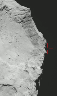
The most remarkable part to me, if the data from the SETI talk is correct, is how low and neatly Philae flew up and over the rim mountains. Altitude is less than 15 meters for an extended period as it hops over the top of that mountain.
Also note that the horizontal component of the trajectory is pretty close to a straight line now. Just slight leftwards nudges at both Impact Points 2 and 3. As mentioned in the SETI talk, those leftward nudges were a godsend, because if Philae had gone straight, or been nudged rightwards, it would have gone right straight into the dark/winter side of the comet. As it is, it's just on the border of the light/dark areas.
One unfortunate thing: The first version of this video (
topview,
Philae view), with Impacts 3/4 in the wrong location, was still a fine visual tour of the head of 67P, taking you past some really amazing cliffs, boulder fields, craters, etc.
Version 2 (
Philae view), with my first guess at Impact Point #3, was still fine visually, with an interesting 'ride the rim' view of the crater.
But now Version 3 (
topview,
Philae's view), clearly the closest to the 'real thing', takes you into the Dark Side of the comet for a good half of the ride. Once you've crossed the rim mountains, it's just dark and dank, with not much to see. So as you're watching the dark screen, just remember: Philae really did go over to the Dark Side, and that's what Philae really saw there--not much of anything! It's really, really dark. Probably darker in real life than what is shown in the simulation.
Compared with that previous versions of the visualization, this version:
-
Moved Impact Point 2 about 25 meters down and left (now it is right on the ridge of Mt. Malmer, which is in accord with ESA data)
-
Reduced the maximum height of the trajectory ellipse from Impact Points 1 to 2 by about 20 meters (in accordance with ESA data; the visualization now matches the 15:43 photograph and data from the SETI talk within a couple of meters)
-
Moved Impact Point 3 a fair distance to match the info from the SETI talk (Impact point 3 was always the point we were guessing at the most). This puts far more of Philae's trajectory 'behind the rim' and in the dark area of the comet
-
Lowered the trajectory Impact point 2-3 quite a bit--now it just scrapes over the top of the rim, by less than 15 meters at some points. This is in accord with data from the SETI talk.
-
Moved Impact Point 4 just a couple of meters to the altitude indicated by data in the SETI talk. This is still not precisely located and could be anywhere within the area ESA indicates in the diagrams linked upthread. (Or elsewhere if ESA is wrong!) Also note that the shape data in this area of the 3D model is vague/incorrect (because it is on the edge of the comet's dark side, there are not enough photos to get good shape data).
- The one piece that doesn't quite harmonize is the
recently released photo of Philae just above the rim at 17:18. There is conflicting information from the SETI talk, previously released impact times for Impacts 3/4, our vague 67P shape model for the region 'beyond the rim' where Philae landed, and this photo (assuming it does show Philae). It's impossible to harmonize all those conflicting sources and make them all work. Just for example, the SETI talk has Impact 3 at 17:16 and Philae at 11 meters above the surface at 17:18. Philae can't be both there AND well above the rim (as shown in the photo from Rosetta's viewpoint; clearly it's more than 11 meters in altitude) at 17:18. So the end of the video is more approximately what happened in approximately the right area of 67P, than exactly what happened in exact places.

 ).
).


 )
)

 One is even holding MUPUS.