I would like to hear what he says on Doug's interview, but maybe he was referring to not seeing the crater, the hole itself.
Imho, VC results very obvious since at least a week ago.
Full Version: Moving south to Victoria
Pages: 1, 2, 3, 4, 5, 6, 7, 8, 9, 10, 11, 12, 13, 14, 15, 16, 17, 18, 19, 20, 21, 22, 23, 24, 25, 26, 27, 28, 29, 30
QUOTE (Tesheiner @ Apr 27 2006, 08:00 AM) 
This is sol 802 pancam mosaic (56ºfov, centered at 160º), at 3/4 size. It looks we have reached a local high point.
Nice. It makes me think it's raining over to the east, though.

That pan seems to show a distant horizon across the entire field of view, which we haven't had before so consistently, so I'd agree with being at or near a high point. Perhaps that's why Oppy keeps perching on top of drifts, although I'm surprised it makes enough difference to be worthwhile.
>but maybe he was referring to not seeing the crater, the hole itself. Imho, VC results very obvious since at least a week ago...
We won't be seeing the crater bowl itself until Oppy is sitting on the edge, but it is clear to me that we are seeing the ejecta blanket and the scalloped areas on the rim of Victoria. The azimuth and the angular size of this feature match the MOC view.
Referring to Aldo's "Anatolia Trough Page", http://www.marsgeo.com/Opportunity/Anatolia.htm , the last image on that page shows several "north-northeast trending elongated pit-like features with dark interiors" and Oppy may pass close to one of these features on the way to Victoria. Hopefully, we'll get a chance to visit this feature.
--Bill
Another move on sol 803 and this is the 360º navcam panorama (L0 filter) taken after driving to the new site (id. 69RR).

Click to view attachment
Edited: Quite a short drive; 7m or so. Perhaps some IDD work during the weekend?
Edited#2: Alan, the bright spot is alive and kicking. See here: http://nasa.exploratorium.edu/mars/opportu...RRP2399L2M1.JPG.
Click to view attachment
Edited: Quite a short drive; 7m or so. Perhaps some IDD work during the weekend?
Edited#2: Alan, the bright spot is alive and kicking. See here: http://nasa.exploratorium.edu/mars/opportu...RRP2399L2M1.JPG.
[quote name='Tesheiner' QUOTE removed - please avoid quoting when replying to the person - unless it's a specific statement - it keeps the forum more readable that way
[/quote]
Is that a festoon I see on the far right of the panorama?
[/quote]
Is that a festoon I see on the far right of the panorama?
No, but I see another sand-filled fissure and dark sand stripe crossing a ripple crest on the right of the panorama.
--Bill
--Bill
Comparing the now fully visible VC with two familiar craters seen from the same distance, ~ 1400 m
(distances and sols from JPL traverse maps)
Bonneville Crater (Spirit Sol 132, a rare good midsol shot halfway between Bonneville and Husband Hill)
http://marsrovers.jpl.nasa.gov/gallery/all...00P1846L0M1.JPG
Endurance & the heatshield, sol 399 (from Vostok)
http://marsrovers.jpl.nasa.gov/gallery/all...00P1785L0M1.JPG
Victoria (partly), sol 803
http://marsrovers.jpl.nasa.gov/gallery/all...RRP0695L0M1.JPG
The profiles of the two familiar ones, along with the 'trackways' leading to them give some idea about the proportions of VC and the distance to go. (Feeling to be within hand's reach already.)
At least VC seems to know how to conceal her inner character, in a proper Victorian manner.
Re the "bright spot", consider this early view of Endurance crater where we can see an illuminated cliff face (Burns Cliff?) on its opposite side -- my very favorite of all panoramas thus far:
http://marsrovers.jpl.nasa.gov/gallery/pre...s-B034R1_br.jpg
http://marsrovers.jpl.nasa.gov/gallery/pre...s-B034R1_br.jpg
One great feature of this pancam shot towards Victoria is that the ground visible in the middle distance, beyond the line of drifts, is already seen to have outcrops. This means that the drifts in that region must be tiny, since for moderate drifts at this low angle, we would see only their crests and no rock. Great driving ahead!
(Oh yes, and there's that fleck of white at a high point on the rim of VC. Let's go crazy and suggest it's a volcanic vent )
)
(Oh yes, and there's that fleck of white at a high point on the rim of VC. Let's go crazy and suggest it's a volcanic vent
)
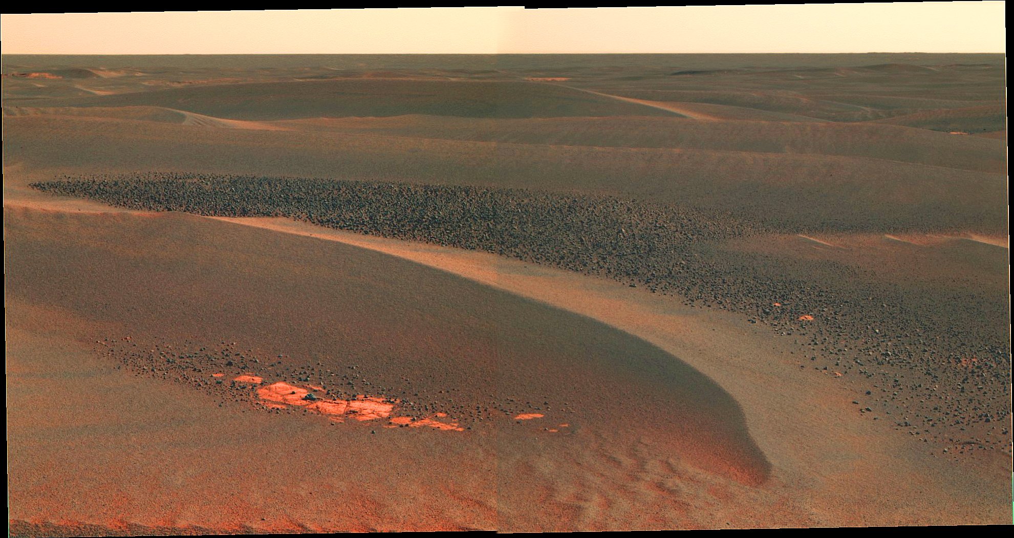
Nobody posted it, so I would like to hear a comment on this stitch of two color PanCam images (L257):
Click to view attachment
This was taken on Sol802 and shows an intriguing deposit of dark material (basalt?).
Click to view attachment
This was taken on Sol802 and shows an intriguing deposit of dark material (basalt?).
My comment is, why didn't we go look at that dark shattered rock (the "blackened stump") near Erebus? That would have been interesting. This irregular dark gravel probably dropped off a similar outcrop that is now buried under one of the drifts.
The dark gravel could be a ray of ejecta from Victoria. Perhaps the impactor penetrated through the normal rock strata we've been seeing so far, and burst open a darker layer. VC will of course have excavated the deepest material we've seen to date.
QUOTE (dilo @ May 1 2006, 11:36 AM)
Nobody posted it, so I would like to hear a comment on this stitch of two color PanCam images (L257):
This was taken on Sol802 and shows an intriguing deposit of dark material (basalt?).
This was taken on Sol802 and shows an intriguing deposit of dark material (basalt?).
It's a beauty, Dilo, and an intriguing enigma. Why these sudden dense fields of the 'crushed rock' that has been so much more sparse further north? The stuff seems to be sitting mostly on top of the sand; I can't see much pale evaporite under it. If it's ejecta, why is it so uniform in size? Will this increasing density continue right up to Victoria? It's probably basalt (isn't everything ultimately?), but how far away (or how far below us) is its source?
Joffan,
I've always wondered the same thing. We must have passed within 2 or 3 meters of it.

We never looked close enough to confirm that is was an outcrop; it could have been just a big, shattered chunk of similar material from somewhere else. We'll never know.

We thought we saw black layers exposed while approaching Erebus, but, when we got there, they were just shadowy layers of pale evaporite like all the rest. Distinguishing real dark minerals from shadows at a distance is not easy.
QUOTE (dilo @ May 1 2006, 04:36 PM)
Nobody posted it, so I would like to hear a comment on this stitch of two color PanCam images (L257):
Click to view attachment
This was taken on Sol802 and shows an intriguing deposit of dark material (basalt?).
Click to view attachment
This was taken on Sol802 and shows an intriguing deposit of dark material (basalt?).
That image shows a change of scenary. That scene includes, finely-layered outcrop rocks, wind ripples and with well distributed black gravel which is called Cobbles. It was seen previously when Oppy approached to the Northern rim of Erebus: Mogollon. Also Cobbles were found close to Payson. However, indeed, the above picture, shows greater density of cobbles that I have ever seen. Cobble might be pieces of ejecta - stuff that has been tossed out of nearby craters by impacts. The other theory is that they are meteorites. These cobbles were eroded down with the presence of water along with the time (decay). These also are called as "rinds". These are, indeed, very basaltic.
Rodolfo
QUOTE (Shaka @ May 1 2006, 04:50 PM)
Joffan,
I've always wondered the same thing. We must have passed within 2 or 3 meters of it.
We never looked close enough to confirm that is was an outcrop; it could have been just a big, shattered chunk of similar material from somewhere else. We'll never know.
Ho hum, we shall indeed never know I guess. I was using "outcrop" loosely just to avoid saying "rock" again, really. I don't expect it was (is) local bedrock. Mind you, I just read Steve Quyres' "Roving Mars" and one thing he was talking about was keeping the Spirit team from stopping at every rock that looked slightly different. That was before the hills, of course, when there was a long period of nothing but basalt. So maybe a similar prioritisation applied here.
I've always wondered the same thing. We must have passed within 2 or 3 meters of it.
We never looked close enough to confirm that is was an outcrop; it could have been just a big, shattered chunk of similar material from somewhere else. We'll never know.
We've been seeing these dark cobbles since before the Erebus Highway: first cobble or two, then these "lag deposits" of increasing concentration. "The Stump" was rather remarkable in that it appeared to be large chunk of ths dark cobble material weathering in-place. This current deposit is remarkable since it is large and concentrated. I want to think that these are lag deposits but sometimes they have the _appearance_ of water-borne gravel. I'l agree with Kenny, we are likely looking at ejecta from Victoria and I'll bet that the ejecta blanket looks just like this deposit.
Oppy did a Moessburg on cobbles at the Erebus Highway and Olympia and found them to be "basaltic", but apparently not interestingly basaltic. I wonder if we have enough views to do a size distribution of the many deposits we've encountered? Are they weathering in place or were they disrupted, tossed and now sit? Can these deposits be spotted on the MOC imagery?
Interesting...
--Bill
QUOTE (Bill Harris @ May 1 2006, 04:17 PM)
Interesting...
--Bill
--Bill
Yes. We have only rarely gotten decent closeup views of this stuff:
http://qt.exploratorium.edu/mars/opportuni...00P1212L0M1.JPG
http://qt.exploratorium.edu/mars/opportuni...23P1201R0M1.JPG
http://marsrovers.jpl.nasa.gov/gallery/all...00P2560R4M1.JPG
http://marsrovers.jpl.nasa.gov/gallery/all...00P2279R1M1.JPG
http://marsrovers.jpl.nasa.gov/gallery/all...I0P1214R0M1.JPG
http://marsrovers.jpl.nasa.gov/gallery/all...J4P1235L0M1.JPG
http://marsrovers.jpl.nasa.gov/gallery/all...MLP1235L0M1.JPG
Personally, the stuff has never looked very worn to me. If moving water affected it, it wasn't for very long. I have considerable difficulties accepting it as ejecta from Victoria. Where are the refrigerator and school bus-sized pieces? I remain to be convinced that Victoria's ejecta didn't wear away over a billion years ago. Maybe when we reach its 'apron', someone will succeed.
I can't believe a significant percentage of it is meteoritic. It may be impact ejecta, but distal ejecta from impacts all over the planet. That would explain the small sizes. It would be nice to use the MI to look for ablation and hypervelocity collision features.
Back on the road tosol...
CODE
807 p0695.03 10 0 0 10 0 20 navcam_5x1_az_162_3_bpp
807 p1151.04 2 0 0 2 0 4 front_hazcam_idd_unstow_doc
807 p1205.06 2 0 0 2 0 4 front_haz_penultimate_0.5_bpp_pri17
807 p1211.03 2 0 0 2 0 4 ultimate_front_haz_1_bpp_pri_15
807 p1275.01 2 0 0 2 0 4 front_hazcam_0.5bpp_pri_41
807 p1305.05 2 0 0 2 0 4 rear_haz_penultimate_0.5bpp_pri17
807 p1311.07 2 0 0 2 0 4 rear_haz_ultimate_1_bpp_crit15
807 p1375.01 2 0 0 2 0 4 rear_hazcam_0.5bpp_pri_41
807 p1585.00 4 0 4 0 0 8 navcam_cloud_4x1_dwnsmp_RVRAz_calstart
807 p2111.05 13 13 0 0 2 28 pancam_cal_targ_L234567Rall
807 p2401.07 8 0 0 8 2 18 pancam_drive_direction_4x1_L2R2
807 p2587.15 2 2 0 0 2 6 pancam_FortBelknap_L2R2
807 p2588.15 13 13 0 0 2 28 pancam_Brookville_L234567Rall
QUOTE (Joffan @ May 1 2006, 05:11 PM)
...why didn't we go look at that dark shattered rock (the "blackened stump") near Erebus?
I was expecting Opportunity to take a look at it. I can only assume that it was concluded that it was the same material as the small cobbles scattered about, a couple of which have been closely examined, and nothing new would be learned from a close examination.
QUOTE (Shaka @ May 1 2006, 10:47 PM)
I have considerable difficulties accepting it as ejecta from Victoria. Where are the refrigerator and school bus-sized pieces?
The dark cobbles' source may be a thin bed of rock. There would be no pieces larger than the thickness of the bed. A size/frequency record of the cobbles as Opportunity approaches Victoria would be interesting. It would be REALLY interesting to see a thin dark layer in Victoria's wall. Of couse if the cobbles are ejecta, there is no reaon why they have to be from Victoria. There are plenty of much larger, deeper craters around.
I'm pretty certain that the cobbles are remnants of basalt inclusions in impact breccias formed by the Erebus, Terra Nova and related ancient cratering events.
The way I see it, there is a cluster of really ancient, highly eroded craters with Erebus and Terra Nova forming the mid-northern portion. There are arcs of rims visible throughout the etched terrain as we go along to the south - southeast, all of which are part of this ancient crater cluster.
So, this ancient cluster originally had complex, inter-related ejecta blankets made up of highly shock-altered breccia and impact melt. Some of that breccia would be derived from the sulfate-rich evaporite, but some of it would be from sandstone that used to be large basaltic sand dunes, and some of it would be from original basaltic crustal formations.
So, imagine a cluster of craters with ejecta that consists mostly of soft, easy-to-erode evaporite with scattered inclusions of harder basaltic clasts. The sulfates are so soft that they've eroded down to the level ground. But where the basaltic rock chunks had been clasts in the soft evaporite matrices of the breccias, they've now "precipitated out" and sit, in scattered fields, buried and unburied, where the softer rock literally eroded out from around them.
If Victoria is anything like on the same time scale of age as Endurance, then I actually doubt we'll see a whole lot in the way of visible ejecta. We'll probably see the "crazy-quilt" rock pattern that we saw at Endurance, where the chaotically emplaced ejecta has been literally eroded down to flat level ground, with little left in the way of raised blocks.
It's amazing to me how completely these craters seem to lose their fine-scale ejecta in this environment. Either that evaporite is *awfully* easy to erode away, or it's just been eroding away for a *long* time.
-the other Doug
QUOTE (centsworth_II @ May 1 2006, 06:49 PM)
There would be no pieces larger than the thickness of the bed.
True, but if any ejecta from the Victoria impact remains, at this distance from the crater, there should be big chunks still in evidence of whatever comprised the bulk of the target rocks (presumably evaporite). By the time those blocks were eroded away, the basalt gravel should have been much more worn than it appears.
I infer that the basalt gravel is a relatively recent arrival, compared to the evaporite and Victoria.
QUOTE (Shaka @ May 2 2006, 01:27 AM)
By the time those blocks were eroded away, the basalt gravel should have been much more worn than it appears.
If the cobbles were originally inclusions as dvandorn suggests, they would have been protected until much of the softer material had been eroded away. The ubiquitous layer of hematite "berries" is indicative of this type of process.
I found it easier to entertain the exploded meteor theory for the cobbles before such concentrated patches of them were found.
Whatever the source of these small cobbles, I think they have been eroded to this size over time.
And I agree with centsworth_II that what we see simply are larger aggregations of the material we've seen smaller collections of earlier, well thats my 2 cents of ideas.
And I agree with centsworth_II that what we see simply are larger aggregations of the material we've seen smaller collections of earlier, well thats my 2 cents of ideas.
I'll predict that we will be seeing significant changes in these cobble deposits as we approach Victoria. My thoughts are that these cobble patches are the VW Beetle sized ejecta blocks weathering into gravel-piles. Clearly, "The Stump" is a boulder that is discombobulating into gravel.
Oppy really needs to stop and smell the roses from time to time...
--Bill
Oppy really needs to stop and smell the roses from time to time...
--Bill
QUOTE (Bill Harris @ May 2 2006, 06:50 AM)
Oppy really needs to stop and smell the roses from time to time...
Do you have a post Sol-900 predicted arrival date?
Wouldnt the ejecta look essentially like the 'stuff' it's ejecting. Consider Fram - yes, I know, very very small - but the small ammount of ejecta there was basically the same stuff that we saw inside Eagle and Endurance - the light coloured sulphate rich rocks.
Are the dynamics of a larger impact really so different that they would render that stuff almost black? Or is there, deep below the light coloured rocks of Eag and End, something alltogether different.
Doug
Are the dynamics of a larger impact really so different that they would render that stuff almost black? Or is there, deep below the light coloured rocks of Eag and End, something alltogether different.
Doug
I chose "eventually" as an arrival date, so I'm covered whenever she arrives.
I think that the ejecta from Victoria is different because it is different. Victoria is deep enough to have disrupted the "basal unit" underlying the Burns Formation. That contact is important in that it will describe the conditions present when this locale of the Burns Fm was laid down. We'll see weathering and paleo-soils and who knows what.
I suppose that the energy from the Victoria impact was large enough to shatter and pulverize the rock, so the physical appearance has changed from the in-situ state.
After a thorough survey of Victoria, if physically possible, Oppy ought to continue the traverse SouthEast, downhill and down-section, back in time.
--Bill
So Oppy not only stopped to smell the blueberries, she whipped out the IDD!
http://qt.exploratorium.edu/mars/opportuni...RRP2956M2M1.JPG
So this implies something demanded attention. Or are they simply just trying to survey the evaporites at the last nice expanse of it before the approach to Victoria, as a way to sample changes over distance in the layers from Endurance -> Voyager -> Erebus -> HellofaView -> Victoria?
Since the cobbles only seem to be associated with dune troughs, here's my lame, unfounded interpretation - they are a subsurface layer formed by cementing basaltic sand at the base of sand dunes. Then the dunes shifted, and exposed the thin crust to crumble and make cobble fields between the dunes. I don't think they are ejecta/crater related, and the only reason we are seeing more of them on approach to Victoria is because the sand is getting deeper.
http://qt.exploratorium.edu/mars/opportuni...RRP2956M2M1.JPG
So this implies something demanded attention.
Or are they simply just trying to survey the evaporites at the last nice expanse of it before the approach to Victoria, as a way to sample changes over distance in the layers from Endurance -> Voyager -> Erebus -> HellofaView -> Victoria?Since the cobbles only seem to be associated with dune troughs, here's my lame, unfounded interpretation - they are a subsurface layer formed by cementing basaltic sand at the base of sand dunes. Then the dunes shifted, and exposed the thin crust to crumble and make cobble fields between the dunes. I don't think they are ejecta/crater related, and the only reason we are seeing more of them on approach to Victoria is because the sand is getting deeper.
A few months back I did an annotated MOC image of this area highlighting paleo-craters. This area has been battered worse than a war zone and there are few areas of the Burns Fm that have been left undisturbed.
Edit: attached is an annotated version of thatEtched Terrain image. I've cropped it to approximately coincide with Tesheiner's Route Map and have drawn on Oppy's route. Erebus is top, left of center. Yellow is the completed path. Cyan is the proposed route. Red is the outline of the paleocraters with Victoria's ejecta blanket outlined in yellow.
I didn't spot that paleocrater before, but I may see one where Oppy is now...
--Bill
Hello,
A 2 image mosaic of the horizon toward Victoria. This is the first color view of crater features I tink....

Click to enlarge...
Also, after the big dune we can see on the foreground, we see on the background a more plane and softly terrain... Is Opportunity will road on the same terrain as the beginnig of the mission?
As this? ==> http://origin.mars5.jpl.nasa.gov/gallery/a...1982R0M1-BR.JPG
A 2 image mosaic of the horizon toward Victoria. This is the first color view of crater features I tink....
Click to enlarge...
Also, after the big dune we can see on the foreground, we see on the background a more plane and softly terrain... Is Opportunity will road on the same terrain as the beginnig of the mission?
As this? ==> http://origin.mars5.jpl.nasa.gov/gallery/a...1982R0M1-BR.JPG
Ant103,
Very nice. Is it just me or did anyone else sit just a bit higher in their chair while looking at that picture in order to try and see a bit further over the big dune?
Chris
Very nice. Is it just me
or did anyone else sit just a bit higher in their chair while looking at that picture in order to try and see a bit further over the big dune?Chris
QUOTE (Ant103 @ May 2 2006, 04:36 PM)
A 2 image mosaic of the horizon toward Victoria. This is the first color view of crater features I tink....
Nice! But that's not toward Victoria; it's to the west.
Apropo crater features, where is the thread "Victoria on the horizon" lost?
Or why?
Or why?
Good point, well made - we don't know where it is or why it's gone...we had a couple of fairly serious hacking attempts a few days ago, and it would coincide with that - still investigating.
Doug
Doug
QUOTE (djellison @ May 2 2006, 08:05 AM)
Are the dynamics of a larger impact really so different that they would render that stuff almost black?
I think the blackness is intrinsic to it's being basaltic as opposed to the white sulphates. If the material of the cobbles was created by impact or explosive volcanism wouldn't it be vesicular like the spongebob rocks at Guseve? The cobbles seem to me to be the broken up results of thin lava flows. Still hoping to see that thin, dark line around the deep interior of Victoria. I have zero expertise in geology, but it's fun to see how far logic and common sense can go to solving a problem.
QUOTE (mhoward @ May 2 2006, 05:14 PM)
Nice! But that's not toward Victoria; it's to the west.
..and was already posted. Anyway, can someone recognize these distant western features, here stretched x10? (Eagle creater should be NNW so shouldn't be there...)
QUOTE (centsworth_II @ May 2 2006, 12:03 PM)
...it's fun to see how far logic and common sense can go to solving a problem.
I'll admit logic but I don't think any of us can claim "common sense" for Mars yet. (Oh yes, and I'll definitely admit fun.
)
QUOTE (Bill Harris @ May 2 2006, 03:17 AM)
We've been seeing these dark cobbles since before the Erebus Highway: first cobble or two, then these "lag deposits" of increasing concentration. "The Stump" was rather remarkable in that it appeared to be large chunk of ths dark cobble material weathering in-place. This current deposit is remarkable since it is large and concentrated. I want to think that these are lag deposits but sometimes they have the _appearance_ of water-borne gravel. I'l agree with Kenny, we are likely looking at ejecta from Victoria and I'll bet that the ejecta blanket looks just like this deposit.
Oppy did a Moessburg on cobbles at the Erebus Highway and Olympia and found them to be "basaltic", but apparently not interestingly basaltic. I wonder if we have enough views to do a size distribution of the many deposits we've encountered? Are they weathering in place or were they disrupted, tossed and now sit? Can these deposits be spotted on the MOC imagery?
Interesting...
--Bill
Oppy did a Moessburg on cobbles at the Erebus Highway and Olympia and found them to be "basaltic", but apparently not interestingly basaltic. I wonder if we have enough views to do a size distribution of the many deposits we've encountered? Are they weathering in place or were they disrupted, tossed and now sit? Can these deposits be spotted on the MOC imagery?
Interesting...
--Bill
Thank you Bill. I tracked the radial from the Sol 802 position to the center of VC and found it goes pretty well through a major embayment (i.e. weakness) in the crater rim. Dykes and sills on earth will rot with water and can end up softer than the general country rock. Sometimes it crumbles down into little cubes. I don't have a probelm with one ray being the little cobbles we saw, then an inter-ray gap, then another ray with bigger blocks- if it reflects different conditons in, say, criss-crossing dykes / sills into which the impactor explosed.
Kenny
Beautiful image of ripples and layers criss-crossing a dune
http://qt.exploratorium.edu/mars/opportuni...RRP2587R2M1.JPG
http://qt.exploratorium.edu/mars/opportuni...RRP2587R2M1.JPG
Just a quick diversion on the road to VC.
For anyone who didn't see Daniel Crotty's calibrated image of Oppy (from sols 569-570) that was posted by marscat on MMB recently - it's certainly worth a look. I love the 'cubist' look to the deck and panels.
Just couldn't resist adding a small SFX touch just for the fun of it.
File:520k
Click to view attachment
Enjoy.
Astro0
QUOTE (alan @ May 2 2006, 10:39 PM)
Beautiful image of ripples and layers criss-crossing a dune
http://qt.exploratorium.edu/mars/opportuni...RRP2587R2M1.JPG
http://qt.exploratorium.edu/mars/opportuni...RRP2587R2M1.JPG
Those bands of sand ripple is very peculiar. That zone has two kind of banding, ones is of horizontal level close to the top of ripples and the ones of above picture, shown with vertical bandings. According to the Marsrovers' WEB: "The banding and other features have inspired a hypothesis that Meridiani ripples are old features that are currently being eroded, and not transported, by wind."
However, the above picture does not relate to the horizontal banding. I seem that these vertical banding are related to eolian erosion.
Rodolfo
QUOTE (RNeuhaus @ May 3 2006, 04:59 PM)
However, the above picture does not relate to the horizontal banding. I seem that these vertical banding are related to eolian erosion.
Rodolfo
Rodolfo
IMHO it does. The reason we are seeing the horizontal bands is becasue the dues are being eroded. The face of the dune showing the banding is the face being eroded, exposing layers within the weakly consolidated interior. Now what exactly caused those layers when the dunes originally formed it still unknown and there are many candidates: dust storms, sesonal changes etc..
A view into the drive direction on Sol 807.
Taken with the L2 pancam.
jvandriel
Taken with the L2 pancam.
jvandriel
The "Beacon" is easily visible without any trick (nearly) in the center of the picture.
Can you see it ?
Can you see it ?
Yes, it's dim, but it's there I couldn't see it at first -mainly to a speck of dust on the screen, right over the spot
Nico
I couldn't see it at first -mainly to a speck of dust on the screen, right over the spot Nico
You're gona need a DD on your screen Nico
A Mi view before and after brushing.
Taken on Sol 804 and 806 with the Mi cam.
jvandriel
Taken on Sol 804 and 806 with the Mi cam.
jvandriel
QUOTE (climber @ May 3 2006, 02:20 PM)
The "Beacon" is easily visible without any trick (nearly) in the center of the picture.
Can you see it ?
Can you see it ?
Actually it's visible despite the reduction in image resolution to about 40% of original in jvandriel's nice panorama. My "no-tricks" crop from the same pancam image is over here
Checking over my big folder of Victoria images, I'm thinking that there is what looks like a small, pyramidal peak capping one of the outcrops on the far side of the crater. It looks particularly clear in some of the 3D images previously posted here... so maybe there's a nice jagged piece of rim rock just sticking its head above the parapet..?
Astro0, nice to see Oppy's PMA. Cool image.
This is a "lo-fi" version of our main content. To view the full version with more information, formatting and images, please click here.