
Full Version: InSight Surface Operations
Pages: 1, 2, 3, 4, 5, 6, 7, 8, 9, 10, 11, 12, 13, 14, 15, 16, 17, 18, 19, 20, 21, 22, 23, 24, 25, 26
Congratulations to the InSight team on a successful landing! We'll discuss the remainder of the mission here.
At nearly 20 feet/6m, InSight should look quite interesting to HiRISE.
Confirmation the solar panels have deployed.
Also the panels are slightly bigger and stronger than Phoenix's were.
Insight Is Catching Rays on Mars.
Also the panels are slightly bigger and stronger than Phoenix's were.
Insight Is Catching Rays on Mars.
It should. Phoenix was unmistakeable even as the dust began to settle on her.
https://mars.nasa.gov/insight-raw-images/su...0000_0106M_.PNG
Are we seeing reflections in the plates of the large structure on the left? It might be handy having some mirrored surfaces to look around corners.
Are we seeing reflections in the plates of the large structure on the left? It might be handy having some mirrored surfaces to look around corners.
Took a stab at cleaning up the MarCO-B cubesat departure image of Mars
Click to view attachment
And with the fisheye effect removed:
Click to view attachment
I think I've managed to ID major landmarks, but am uncertain.
Click to view attachment
Click to view attachment
And with the fisheye effect removed:
Click to view attachment
I think I've managed to ID major landmarks, but am uncertain.
Click to view attachment
Ok Phil, how long before you triangulate Insight based on that large rock in the distance? 
QUOTE (marsophile @ Nov 27 2018, 03:35 AM) 
https://mars.nasa.gov/insight-raw-images/su...0000_0106M_.PNG
Are we seeing reflections in the plates of the large structure on the left? It might be handy having some mirrored surfaces to look around corners.
Are we seeing reflections in the plates of the large structure on the left? It might be handy having some mirrored surfaces to look around corners.
That's the seismometer...
Seismometer.
QUOTE (jccwrt @ Nov 26 2018, 07:36 PM)
I think I've managed to ID major landmarks, but am uncertain.
I got similar results. Good news is - this image was heavily JPG compressed to get on the ground quick. A raw uncompressed version should be down....hopefully....tomorrow. I think Mars should look a LOT better without JPGification. Hopefully
QUOTE (djellison @ Nov 26 2018, 10:13 PM)
I got similar results. Good news is - this image was heavily JPG compressed to get on the ground quick. A raw uncompressed version should be down....hopefully....tomorrow. I think Mars should look a LOT better without JPGification. Hopefully
Awesome. Something I've been curious about - was this the only planned image during the flyby, or will there be others as well?
Great news!
I'm looking forward to the MRO images of the chute & backshell on the surface, and hopefully the heat shield as well. Always interesting to see how those ended up.
I'm looking forward to the MRO images of the chute & backshell on the surface, and hopefully the heat shield as well. Always interesting to see how those ended up.
QUOTE (jccwrt @ Nov 26 2018, 08:20 PM)
Awesome. Something I've been curious about - was this the only planned image during the flyby, or will there be others as well?
Should be a few more - not many - but a couple on the way in and a couple on the way out. A few from MarCO A as well ( this is from B )
Looking forward to seeing them!
So, simple question, how many images are planned to be taken by the ICC and IDC during Sols 0-2?
Emily says in her "What to Expect" article at the Planetary Society ...
Mars Insight Landing Preview
... that the Cruise Stage wreckage will impact up-range (east) of the landing site.
Given the thin atmosphere and high altitude of the area, might we expect some components to survive entry and make it down to the surface?
Mars Insight Landing Preview
... that the Cruise Stage wreckage will impact up-range (east) of the landing site.
Given the thin atmosphere and high altitude of the area, might we expect some components to survive entry and make it down to the surface?
A live view of the engineers reactions (YouTube) - a team sometimes less-mentioned: success, hugs, high-5's, fist-bumps, love, of exploration.
John
John
The MSL cruise stage made it to ground in pieces, and the splats were seen by HiRISE.
https://www.uahirise.org/ESP_029245_1755
Phil
https://www.uahirise.org/ESP_029245_1755
Phil
Thanks Phil. So no tungsten blocks this time, but I'm guessing there will surely be a lighter splatter out there somewhere.
In the early stages of the mission, can InSight's seismometer be used in concert with the hammer that is to drive the thermal mole into the ground, as a sort of sonar device to help locate buried rocks and maybe identify the best path to get the mole all the way to its desired 5 meter depth?
Sorry- this belongs in the surface operations thread, which is where I intended to put it. I guess I can't move it now without some assistance from admin...
Moved. -Admin.
Sorry- this belongs in the surface operations thread, which is where I intended to put it. I guess I can't move it now without some assistance from admin...
Moved. -Admin.
Right! So in this image:
https://static.uahirise.org/images/2012/det...BM-2H-scale.jpg
the two largest splats are thought to be the tungsten blocks, but all the others are fragments of the cruise stage. Something similar should be visible to us this time.
Every previous US lander except the Vikings had cruise stages which would have done this, but we didn't have a great camera to look for them before this (exception, Phoenix, but I never saw a search for cruise stage scars - maybe CTX from just after the Phoenix landing would reveal cruise stage impacts). Presumably the older mission cruise stage scars would be faded by now.
Phil
QUOTE (tanjent @ Nov 27 2018, 04:40 PM)
In the early stages of the mission, can InSight's seismometer be used in concert with the hammer that is to drive the thermal mole into the ground, as a sort of sonar device to help locate buried rocks and maybe identify the best path to get the mole all the way to its desired 5 meter depth?
Moved. -Admin.
Moved. -Admin.
There was no mention of that. The PI did say small rocks would be pushed aside by the Mole, but if it hit a big flat rock then that was as far as they could go, it won't go upwards. It's all about risk.
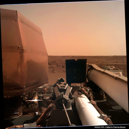
My initial (and highly speculative) impression from the first images from each camera is that Insight has luckily landed inside one of those circular sandy areas that we first saw at the Spirit rover landing site in 2004. I think they were perhaps shallow craters in-filled with wind-blown dust and sand. The flat sandy terrain visible by the landing leg seems to finish abruptly a few tens of meters off, at rougher boulder terrain, from the higher viewpoint looking out alongside the seismometer cover.
But we will find out more fully in due course !
But we will find out more fully in due course !
First of all, a big applause for the team which have landed InSight on Mars. They've done it. Again. I am grateful to live such great moments
Second, I put my hand on the first IDC image downlinked, to remove some artifacts, review a little bit the colors.
And, I got my website updated, so it can receive further processing based on IDC (and maybe ICC).
Second, I put my hand on the first IDC image downlinked, to remove some artifacts, review a little bit the colors.
And, I got my website updated, so it can receive further processing based on IDC (and maybe ICC).
QUOTE (kenny @ Nov 27 2018, 06:12 PM)
... The flat sandy terrain visible by the landing leg seems to finish abruptly a few tens of meters off, at rougher boulder terrain, from the higher viewpoint looking out alongside the seismometer cover...
To my eyes it looks like sandy spots interspersed with rocky spots. A billion years of wind and no rain can do strange things...
And I still don't think it was the parking lot they expected.
QUOTE (MahFL @ Nov 27 2018, 10:12 AM)
And I still don't think it was the parking lot they expected.
In the IDC image there is exactly one rock that could have caused a landing issue. There's nothing else out there that looks like it could have been an impairment to landing, or instrument deployment.
This is exactly what was expected.
From https://sharad.psi.edu/~ibsmith/pubs/Golombek_SSR_2016.pdf
"Rock abundance in the smooth terrain averages ∼2.5 % (well below the 10 % requirement)"
Seems we got what we ordered.
This is what HiRISE looks like in the approximate landing area (image number in file name if you save it). Lots of smooth patches between slightly rougher patches. Really not too many serious hazards. I'm looking! But we don't have much to go on yet.
Phil
Click to view attachment
Phil
Click to view attachment
QUOTE (tanjent @ Nov 27 2018, 11:40 AM)
In the early stages of the mission, can InSight's seismometer be used in concert with the hammer that is to drive the thermal mole into the ground, as a sort of sonar device to help locate buried rocks and maybe identify the best path to get the mole all the way to its desired 5 meter depth?
Yes, and no. Yes, the seismometers will listen as the HP3 mole hammers itself into the ground, and will deduce near-surface seismic properties therefrom. Conceivably one could deduce the presence of reflectors such as buried rocks, although I don't know how unique such analyses would be.
However, the mole is not steered. It just drives itself downwards.
Ralph
Thanks for that link Doug. The tolerance of the lander to rocks in the landing site is impressive. Rocks up to 45 cm high underneath a footpad, rocks up to 45 cm high underneath the lander, and rocks up to 55 cm high underneath the deployed solar arrays. less 10 cm in all cases if excess energy has been absorbed by crushable material inside the lander legs.
There are three new images for Sol 1, the same two angles from Sol 0, just a difference in shadows.
New images are up.
Another from the workstation camera, the cover is still on as of Sol 1.
https://mars.nasa.gov/insight-raw-images/su...0000_0589M_.PNG
There's a couple new images from the robotic arm camera, one shows some movement of .. I think the grappling device at the end of the arm?
https://mars.nasa.gov/insight-raw-images/su...0000_0463M_.PNG
Some of the dust on the camera lens has moved around. Hard to say if this is from wind or because movement from the grapple gently shook some of it off.
Click to view attachment
Click to view attachment
Doing a further max with the new ICC frame doesn't improve my sol 0 2-frame image much, since not much dust has moved and the lighting is different in the sol 1 image which causes artifacts especially near the centre of the frame, but here it is anyway:
Click to view attachment
Click to view attachment
Not quite the same (I wrote this replying to fredk), look how the grapple moves between the two Sol 1 IDC images. And they are at different times of day so shadows move, including in the ICC images between sols 0 and 1.
Phil
Phil
Here is a gif of Insight's deck from the IDC cam...
(the camera is on the 'forearm' section of the folded arm assembly)
Click to view attachment
(the camera is on the 'forearm' section of the folded arm assembly)
Click to view attachment
The new dance craze for all the cool kids this Northern Hemisphere winter will be the Grapple Snapp! Thanks, PDP.
A word on expectation management: The InSight team took great pains, I'd say, to emphasize that this mission will be considerably slower-paced than what we've become accustomed to over the years for Mars. Seems that I heard that surface instrument deployment probably won't begin till well after the holidays, though since it seems that they've begun testing arm mechanical functions we should see some of that at least in the near future.
Also, they'll of course have to survey the putative instrument placement sites before making a commitment; that will doubtless take some time.
All good. I guess geophysics missions require something a tiny bit closer to geological timescales to do right.
Thanks, PDP.A word on expectation management: The InSight team took great pains, I'd say, to emphasize that this mission will be considerably slower-paced than what we've become accustomed to over the years for Mars. Seems that I heard that surface instrument deployment probably won't begin till well after the holidays, though since it seems that they've begun testing arm mechanical functions we should see some of that at least in the near future.
Also, they'll of course have to survey the putative instrument placement sites before making a commitment; that will doubtless take some time.
All good. I guess geophysics missions require something a tiny bit closer to geological timescales to do right.
Yes, there's no wheels on this one. The nearest comparison is with Phoenix, and the team then was working with a much stricter deadline (Martian polar winter!) than InSight has. I'd be happy with a 360 panorama by Christmas!
Just playing here, with the 3 IDC images making 2 pairs. These are difference images showing subtle changes - not so subtle on the deck where shadows and actual movement, but ignore that. The sky shows subtle changes between the two pairs, possibly related to clouds - very diffuse clouds - passing overhead. They have a radiometer to look for differences in illumination because it affects the heat flow, and those differences would include time of day, tau and cloud shadows.
Phil
Click to view attachment
Phil
Click to view attachment
Thanks Phil. I hope we see some Philo-vision [TM] as soon as we get a significant stretch of the horizon in view!
I'm actually really looking forward to the meteorology package and magnetometer data.
Any idea when and where we might see that appear?
Another Phil
I'm actually really looking forward to the meteorology package and magnetometer data.
Any idea when and where we might see that appear?
Another Phil
QUOTE (antipode @ Nov 27 2018, 08:24 PM)
Any idea when and where we might see that appear?
Without providing information that is not to be made public, from the timeline I have seen for the near term, it looks like images with different viewpoints and other hoped for things will occur this week. Sort of like the first ten plays of a football game, the sol days 0-5 are pre-scripted and will occur roughly on the planned timeline (unless of course issues arise). Sol 1 had a planned grapple lock down release (as you see in the photos). Array power is above predicts (as things usually are since the predicts are a worst case analysis) which is a great result.
QUOTE (Phil Stooke @ Nov 28 2018, 03:57 AM)
These are difference images showing subtle changes - not so subtle on the deck where shadows and actual movement, but ignore that. The sky shows subtle changes between the two pairs, possibly related to clouds - very diffuse clouds - passing overhead.
Some of the differences may be due to the onboard jpeg compression.
Since the insight "raw" site is providing png's, that hopefully means that they are lossless relative to the received images - it wouldn't make sense to re-jpeg the received images and then convert those to pngs.
I haven't heard anything about the original true raw images (ie, before onboard jpeg compression) eventually being sent home.
QUOTE (Phil Stooke @ Nov 27 2018, 01:07 PM)
This is what HiRISE looks like in the approximate landing area (image number in file name if you save it). Lots of smooth patches between slightly rougher patches. Really not too many serious hazards. I'm looking! But we don't have much to go on yet.
Phil
Click to view attachment
Phil
Click to view attachment
This land does not look to be a windy place since it has no lines of a bump of sand.
We haven't seen much of it yet! Lots more to see when the arm is raised.
Phil
Phil
One result from the seismometer is expected to be the detection of impacts on Mars. And look at this, one occurred about 5 or 6 km from the landing site only 3 years ago.
Phil
Before impact:
Click to view attachment
After impact:
Click to view attachment
close-up:
Click to view attachment
Phil
Before impact:
Click to view attachment
After impact:
Click to view attachment
close-up:
Click to view attachment
Looks like it broke up in the air before impacting. Probably not great for probing the core right?
Being that close is not good for probing the core. For the core we need a big impact more than 60% of the way around the planet so waves pass through or around the core on the way to the seismometer.
Phil
Phil
I had completely forgotten that I took a few pictures of an InSight mockup and French seismometer at the Le Bourget Airshow in 2015
https://www.flickr.com/photos/9228922@N03/1...57654838335682/
https://www.flickr.com/photos/9228922@N03/1...57654838335682/
https://www.flickr.com/photos/9228922@N03/1...57654838335682/
https://www.flickr.com/photos/9228922@N03/1...57654838335682/
https://www.flickr.com/photos/9228922@N03/1...57654838335682/
https://www.flickr.com/photos/9228922@N03/1...57654838335682/
An article by Paul Voosen on the Science site, based on an interview with Matt Golombek, contains interesting details of JPLs initial assessment of Insights landing area.
https://www.sciencemag.org/news/2018/11/mar...g-study-planets
https://www.sciencemag.org/news/2018/11/mar...g-study-planets
Good news from To's link regarding the sandy interior of a hollow!
Wondering about this bit though:
They can't slew HiRise a little to the side where the IMU says the lander is? (my avatar's existence tells me MRO can do it) Or is the imaging strip just too thin to guarantee catching it on Thursday?
Wondering about this bit though:
QUOTE
The biggest mystery for the lander team right now is figuring out exactly where it is. A Mars orbiter set to image the center of the landing zone on Thursday will miss the lander, because it missed the center slightly. An instrument on InSight called the inertial measurement unit has pinned the location to within a 5-kilometer-wide circle. InSight’s entry, descent, and landing team will refine that estimate down to a kilometer or less.
They can't slew HiRise a little to the side where the IMU says the lander is? (my avatar's existence tells me MRO can do it) Or is the imaging strip just too thin to guarantee catching it on Thursday?
MRO receives command sequences only a few times a month; its command load for the Thursday image is already onboard and can't be changed now.
This is a "lo-fi" version of our main content. To view the full version with more information, formatting and images, please click here.