Full Version: InSight Surface Operations
Pages: 1, 2, 3, 4, 5, 6, 7, 8, 9, 10, 11, 12, 13, 14, 15, 16, 17, 18, 19, 20, 21, 22, 23, 24, 25, 26
Love this one of two of the decent rockets, a landing leg, the ICC camera and the disturbed ground under the lander.
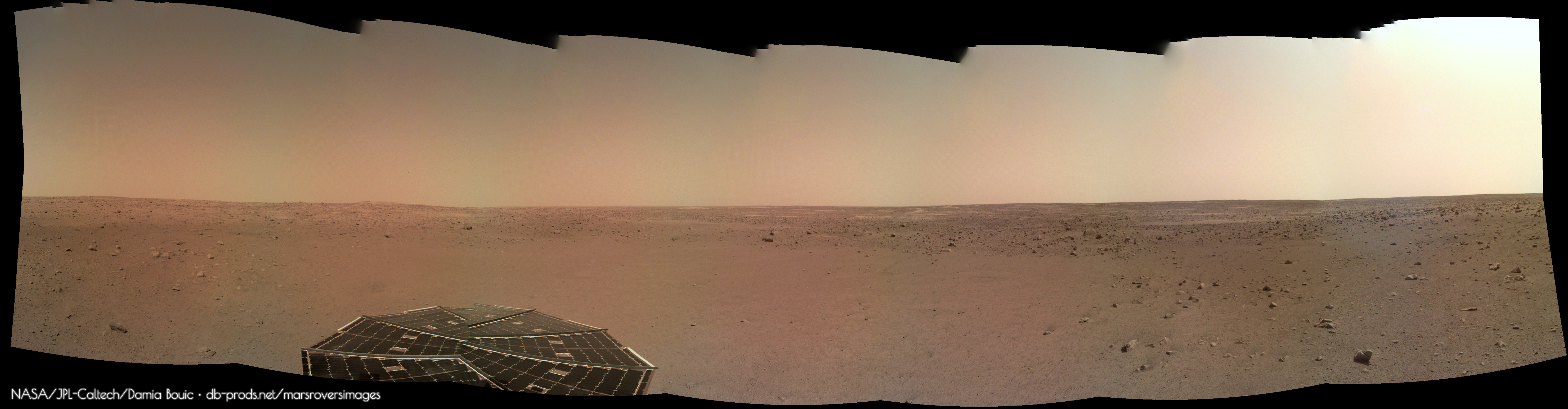
As it is past 1am here in Melbourne here is just a quick go at one of the horizon panoramas taken on sol 14.
 InSight sol 14 Horizon by nivnac, on Flickr
InSight sol 14 Horizon by nivnac, on Flickr
QUOTE (jamescanvin @ Dec 11 2018, 07:00 AM) 
Love this one of two of the decent rockets, a landing leg, the ICC camera and the disturbed ground under the lander.
That is the type of photo I have been hoping for! Looks great. Regarding the earlier quote of mine about thrusters and the 3rd leg, those images are all down. I was referring to the cruise thrusters, not the descent ones. Looks like we excavated quite a hole between the descent thruster clusters (there are more thrusters on the backside to the right you can't see in this image).
This is James's sol 14 panorama in circular form. I don't know exactly how much is missing, and small horizon offsets are exaggerated in my projection.
We landed in the best place in that whole scene.
Phil
Click to view attachment
We landed in the best place in that whole scene.
Phil
Click to view attachment
My version of this panoramic 

very nice panoramas shaping up!
continuing attempts to wring islands of stereo imagery out of the latest sol14 thrusters and blasted soils
Click to view attachmentClick to view attachmentClick to view attachmentClick to view attachment
continuing attempts to wring islands of stereo imagery out of the latest sol14 thrusters and blasted soils
Click to view attachmentClick to view attachmentClick to view attachmentClick to view attachment
Nice panos!
Its clearly not a parking lot. Lots of undulating ground at all scales.
At some azimuths I get the impression I can see for many kilometers.
Lines of small dunes/drifts in the middle distance. Big rocks.
What looks like a couple of crater rims on the horizon, and at least once very distant hill.
Phil, have you managed to refine the location at all based on the sol 14 imagery?
Another Phil
No, not yet, but I'm looking. Meanwhile:
https://twitter.com/ExoMars_CaSSIS/status/1...638302845657094
HiRISE has it! We should see it soon.
Phil
https://twitter.com/ExoMars_CaSSIS/status/1...638302845657094
HiRISE has it! We should see it soon.
Phil
QUOTE (Phil Stooke @ Dec 11 2018, 07:34 PM)
No, not yet, but I'm looking. Meanwhile:
https://twitter.com/ExoMars_CaSSIS/status/1...638302845657094
HiRISE has it! We should see it soon.
Phil
https://twitter.com/ExoMars_CaSSIS/status/1...638302845657094
HiRISE has it! We should see it soon.
Phil
Yes, HIRISE is supposed to release an image later this week. I have seen an image that shows the lander, heatshield, and backshell/parachute location. Have not seen the actual HIRISE image but instead a pre-landing one with dots on the spots where those are located. Can't wait to see the actual image. Sorry not allowed to distribute the photo I was shown.
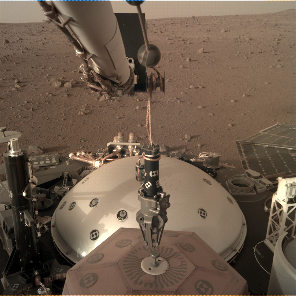
Just a new thought here. Most of us have heard the "sound" of winds moving around insights solar panels audio recorded by the seismometer I think.
Could these vibrations transfer to the ground and hinder the supper sensitive seismometers work?
Could these vibrations transfer to the ground and hinder the supper sensitive seismometers work?
QUOTE (monty python @ Dec 12 2018, 08:22 AM)
Just a new thought here. Most of us have heard the "sound" of winds moving around insights solar panels audio recorded by the seismometer I think.
Could these vibrations transfer to the ground and hinder the supper sensitive seismometers work?
Could these vibrations transfer to the ground and hinder the supper sensitive seismometers work?
They said it was unlikely, that's why they want it on the ground, also they would be able to characterise the noise of the vehicle and be able to ignore or recognise it during the long silent listening phase, if it did indeed transfer.
Is the InSight image file naming convention publicly available? If so, does anyone here have a link to it
TIA
TIA
QUOTE (Ant103 @ Nov 29 2018, 11:04 AM)
What happened to the "raw" images page ?
https://mars.nasa.gov/insight/multimedia/raw-images/
There is none.
https://mars.nasa.gov/insight/multimedia/raw-images/
There is none.
I have a different issue: the raw images page does not work in my browser (Basilisk). I have to use Chrome to get the images.
I wrote NASA to inform them of this issue, but no response yet.
By the way: the feedback link on the InSight webpage did not work either (in Chrome); so I used the general NASA Mars page for my feedback.
It seems the InSight page was developed in a hurry: I never had this mess before (except perhaps with the revamped Cassini webpage a few years ago, but I got a speedy reply, and the issue was solved quickly).
to me, the site seems to be very slow at times. I think it does not load thumbnails, but it needs to load the full resolution images when you open it
Agreed, thumbnails would be better. And a way to view a list of sols without having to manually enter the sol values would be nice. It would be great if someone could create their own site, akin to those people here have for MER and MSL. But unfortunately that would mean having to code up a harvester from scratch.
QUOTE (fredk @ Dec 12 2018, 04:07 PM)
Agreed, thumbnails would be better. And a way to view a list of sols without having to manually enter the sol values would be nice. It would be great if someone could create their own site, akin to those people here have for MER and MSL. But unfortunately that would mean having to code up a harvester from scratch.
I'm trying to write a "harvester", but I'm afraid I won't be able to finish after New Year

QUOTE (MahFL @ Dec 12 2018, 12:42 AM)
They said it was unlikely, that's why they want it on the ground, also they would be able to characterise the noise of the vehicle and be able to ignore or recognise it during the long silent listening phase, if it did indeed transfer.
Also remember that the seismometer will have a 'hat' installed over it, and minimizing wind vibration is one of the reasons for that.
Here's an anaglyph from the sol 14 frames. I inverted the view for visual comfort.
I only intended to post the top image. The bottom image has some bad shadow artifacts.
Click to view attachment
I only intended to post the top image. The bottom image has some bad shadow artifacts.
Click to view attachment
QUOTE (nprev @ Dec 12 2018, 09:49 AM)
Also remember that the seismometer will have a 'hat' installed over it, and minimizing wind vibration is one of the reasons for that.
Yes, wind induced noise is a very big concern for SEIS and has been accounted for in the design. As mentioned there is the 'hat' (known as the WTS or Wind and Temperature Shield) plus the instrument cable tether box (that round thing that shows in the upper left of the ICC images) is very complicated in an effort to ensure the lander does not load the instrument as the vehicle moves in the wind. The cable attachment to the instrument even has a flex plate that will drop off to again limit motion to the instrument even if the cable were to move. There is a very good description of the instruments at: Link to Spaceflight101.
Thanks, Propguy.
Quick question re the WTS: How much is it expected to reduce the amount of temperature variation? I can't imagine that the instrument itself will produce much in the way of stray heat, though maybe it doesn't take much to make a significant (and calibrate-able) difference in terms of performance.
Quick question re the WTS: How much is it expected to reduce the amount of temperature variation? I can't imagine that the instrument itself will produce much in the way of stray heat, though maybe it doesn't take much to make a significant (and calibrate-able) difference in terms of performance.
QUOTE (nprev @ Dec 13 2018, 10:56 AM)
Thanks, Propguy.
Quick question re the WTS: How much is it expected to reduce the amount of temperature variation?
Quick question re the WTS: How much is it expected to reduce the amount of temperature variation?
I imagine that the soil covered by the WTS will provide some extra heat capacity that will stabilize the temp variation somewhat more than the air temperature
Right, and the anchors on the seismometer will also stab down into the soil a bit to provide better surface bonding for signal detection, which will also help with temperature stabilization.
I suspect that the W is the primary purpose of WTS, not the T.
I suspect that the W is the primary purpose of WTS, not the T.
This pdf -https://ttu-ir.tdl.org/ttu-ir/bitstream/handle/2346/59518/ICES-2014-64.pdf
Charts - especially on pages 14 and 15 - show the WTS, combined with a small heater on SEIS itself - makes quite a dramatic different to the temperature swings experiences by SEIS.
Charts - especially on pages 14 and 15 - show the WTS, combined with a small heater on SEIS itself - makes quite a dramatic different to the temperature swings experiences by SEIS.
I've done a V2 of my workspace model, complete with WebVR scaling - https://sketchfab.com/models/038d4924308f4c...00fe492b1450997 - I think it's to approx the right scale - I used the width of the blue margin in this image - https://photojournal.jpl.nasa.gov/catalog/PIA22874 - as a guide ( as the blue margin represents the radius of the SEIS WTS I believe )
As a result - take these with a pinch of salt - but an orthoimage and a dem with a 50cm grid overlay, attached.
As a result - take these with a pinch of salt - but an orthoimage and a dem with a 50cm grid overlay, attached.
Thanks for that thermal paper, Doug. Dramatic improvement indeed, and I was unaware of the heater. Count me as a WTS fan, emphasis on the T!
Re your DEM: The scale is cm for the elevation contours, right? Regardless, hard to ask for a flatter place than that.
Re your DEM: The scale is cm for the elevation contours, right? Regardless, hard to ask for a flatter place than that.
The DEM scale is M, so about 15cm across the entire thing. Incredibly flat.
Here is my take on the sol 14 panorama of the landing site. I prepare a version with a filled sky.

Sol 16 IDC & ICC images have been downlinked to the server, so far 50 are posted
link
link
It's official, HiRISE image of the InSight hardware: https://www.uahirise.org/releases/insight/hardware/
The orbital view shows blast effects out to roughly 20 metres or so from Insight. So Phil's circular post showing us at a "bull's eye" location is probably just due to the engines - there's nothing too unusual about the location.
raw images for Sol 18 are up. they seem to indicate that seismometer deployment is imminent
If I oriented myself correctly, I think I identified a few major boulders and craters visible in the sol14 panorama with what I see in the HiRISE images. 
(using Phil Stooke's image for inlay)
Click to view attachment
The low "ridge" is also visible behind the "A" boulder.
(using Phil Stooke's image for inlay)
Click to view attachment
The low "ridge" is also visible behind the "A" boulder.
Sol 18 stereo views. Cross-eyed:
Click to view attachment
Click to view attachment
And anaglyphs:
Click to view attachment
Click to view attachment
There are uncorrected distortions here, so these may cause eyestrain...
Click to view attachment
Click to view attachment
And anaglyphs:
Click to view attachment
Click to view attachment
There are uncorrected distortions here, so these may cause eyestrain...
This tweeter feed from &MoonNext show how theyve reproduced InSights work place a-t-il JPL
Edit : be uploaded 4 Times and cant see it on my post to delete, sorry
Fixed, and thanks! - Admin
Edit : be uploaded 4 Times and cant see it on my post to delete, sorry
Fixed, and thanks!
- Admin
New pics down, lowering grapple to the seismometer, my question is are they ready to deploy it ?
QUOTE (MahFL @ Dec 16 2018, 12:47 PM)
New pics down, lowering grapple to the seismometer, my question is are they ready to deploy it ?
Looks like they are ready... Judging by this Tweet from SEIS: Link
Translation: "The grapple that will lead me to the surface of Mars has just positioned itself above me! The week ahead is going to be historic, I would say, SEIShistorique!"
Awesome.
If I'm not mistaken this is well ahead of the planned schedule, is it not? Wonder if they expected the site survey to take much longer than it apparently did.
Before landing there was a possibility that the site would need a bit of grooming, moving a few pebbles aside or something like that. So some time gets saved there. Even so this current operation might only be checking the positioning of the arm above the instrument rather than the actual pick-up. But maybe this is it! I had wondered if there might be a few bearing tests etc. - pressing the arm down on the surface to estimate its properties. But maybe that's not needed.
Phil
Phil
We also had a Tweet from Jean-Yves Le Gall @JY_LeGall (CNES / ESA) link
"Mars. The SEIS's deployment operations will begin. InSight's arm positioned its pliers over SEIS..." (roughly translated from French)
"Mars. The SEIS's deployment operations will begin. InSight's arm positioned its pliers over SEIS..." (roughly translated from French)
I recall seeing a tweet some days ago implying that the seismometer would be deployed during next week, but I don't seem to be able to find it
Yep, me too.
Good traduction from french actually
Good traduction from french actually
Any idea how the raw images are being named?
eg:
D000M0018_598143893EDR_F0000_0532M_
So, the little I know is,
D is Deployment Camera C is Context Camera
000 ? Not sure - range is D000 to D058
M0018_ ? Not sure - This can also be L0018 or R0018 I assume Left/Right but what is M?
598143893 is seconds after Jan 1/2000 - December 14, 2018 at 11:04 p.m.
EDR? (All images have EDR)
F0000_ ? Filter?
0532M_ ?
Thanks!
Mark
I assume M is for Mono, like the picture is not coming from stereopair. So it's single.
About the filename, do you have a way to convert seconds from Jan 1st 2000 and get a GMT formated time ?
About the filename, do you have a way to convert seconds from Jan 1st 2000 and get a GMT formated time ?
QUOTE (Ant103 @ Dec 16 2018, 03:47 PM)
I assume M is for Mono, like the picture is not coming from stereopair. So it's single.
About the filename, do you have a way to convert seconds from Jan 1st 2000 and get a GMT formated time ?
About the filename, do you have a way to convert seconds from Jan 1st 2000 and get a GMT formated time ?
I just added that many seconds to Jan 1/2000 in Excel and it worked. I think it must be GMT already.
QUOTE (MarkL @ Dec 16 2018, 06:36 AM)
...
EDR? (All images have EDR)
F0000_ ? Filter?
0532M_ ?
...
EDR? (All images have EDR)
F0000_ ? Filter?
0532M_ ?
...
EDR stands for Engineering Data Record, the image as it was captured, without rectification (that would be named RDR, Reduced Data Record).
F000_0532 looks like a sequence name? Doug would definitely know.
Paolo
QUOTE (MarkL @ Dec 16 2018, 06:36 AM)
598143893 is seconds after Jan 1/2000 - December 14, 2018 at 11:04 p.m.
Based on the most recent clock drift file, that time maps to 2018 DEC 15 11:05:20 assuming it's really a raw SCLK value. 0 SCLK is nominally 2000-001T12:00.
CODE
from spice import *
furnsh("naif0012.tls")
furnsh("NSY_SCLKSCET.00010.tsc")
t0=scs2e(-189,"598143893")
print "t0", t0, et2utc(t0, "c", 0)
furnsh("naif0012.tls")
furnsh("NSY_SCLKSCET.00010.tsc")
t0=scs2e(-189,"598143893")
print "t0", t0, et2utc(t0, "c", 0)
Thank you guys. Very helpful.
This is a "lo-fi" version of our main content. To view the full version with more information, formatting and images, please click here.