Help - Search - Members - Calendar
Full Version: InSight Surface Operations
Unmanned Spaceflight.com > Mars & Missions > Past and Future > InSight
Pages: 1, 2, 3, 4, 5, 6, 7, 8, 9, 10, 11, 12, 13, 14, 15, 16, 17, 18, 19, 20, 21, 22, 23, 24, 25, 26
Liss
QUOTE (PaulH51 @ Nov 30 2018, 03:47 AM) *
Does anyone know if they have an official mission clock for InSight? Similar to the one we have for Curiosity link that shows the sol and current solar time.

There's another question: is it correct that the nine-digit number in the image filenames is the time in seconds from 2000-Jan-01 12:00 UTC?
Phil Stooke
A new bit of the horizon in one of the new images:

Click to view attachment

It's to the left of the first IDC image we saw. Boulders are visible on the horizon, so it is not far away, in contrast to the more distant horizons in the ICC and first IDC images.

There is supposed to be a new HiRISE attempt on the site today.

Phil
mcaplinger
QUOTE (Liss @ Dec 6 2018, 04:24 AM) *
is it correct that the nine-digit number in the image filenames is the time in seconds from 2000-Jan-01 12:00 UTC?

Nominally, but the clock isn't perfect and drifts a small amount. See https://naif.jpl.nasa.gov/pub/naif/INSIGHT/...KSCET.00009.tsc

And I don't know what the relationship between the time and the actual exposure time is for InSight. It takes tens of seconds to read the image out, though, so it might be off by that much at least.
Explorer1
12 new images on the raws page, showing lots of arm and scoop movements (as well as some pretty clear streaks in the soil from the thrusters!)
atomoid
Stereo attempt from images 38 and 39 showing the deck, challenging parallax between near/far, so the lander deck is optimized for crosseye/anaglyph.
Click to view attachment Click to view attachment
neo56
Nice one atomoid!
Here is a rough stitching of 3 IDC pictures received today:

atomoid
very nice stitch, you get a sense how deep the thrusters scoured away of what seem to be at least a cm or more of dust. Here's another stereo, this of img 31 and 32 try to get a feel of the local topography (flat!), IDC was apparently rotated 180 degrees into upside down position when it snapped these! optimized for the ground 2/3 up frame.
Click to view attachmentClick to view attachment
Phil Stooke
Very nice work with the images! I really like that mosaic.

Taking a different approach, here I am building a mosaic of the surface with minimal blocking by spacecraft components, by overlaying images and replacing sections of one image with another which is not hidden by part of the lander. The goal is a full mosaic of the workspace. It will be distorted at first, but later it can be morphed to fit proper control.

Phil

Click to view attachment
Phil Stooke
From the new press release:

"These images will help mission team members determine where to set InSight's seismometer and heat flow probe — the only instruments ever to be robotically placed on the surface of another planet."


Ok, planet... yes, OK. But on the Moon, Surveyor 7 used its arm to pick up its Alpha [Particle] Spectrometer Instrument and place it in several different positions. Surveyors 5, 6 and 7 had ASI instruments, forerunners of the modern APXS used on our Mars rovers and on Chang'e 3. They were just dropped from a bracket on the lander to the surface. But S7 used its arm to reposition it 3 times.

Phil

Click to view attachment
RoverDriver
QUOTE (mcaplinger @ Dec 6 2018, 12:04 PM) *
Nominally, but the clock isn't perfect and drifts a small amount. See https://naif.jpl.nasa.gov/pub/naif/INSIGHT/...KSCET.00009.tsc

And I don't know what the relationship between the time and the actual exposure time is for InSight. It takes tens of seconds to read the image out, though, so it might be off by that much at least.


Aside from clock drift, I think the filename reflects the timestamp when the data product is created, not necessarily the time of capture or readout.

Paolo
Phil Stooke
My previous mosaic can be fitted with the foreground of the ICC image (using the latest low-sun version). As much as possible of that area will be replaced with IDC images as they become available. Again - distorions abound but will be corrected later.

Phil

Click to view attachment
MahFL
"The mission's primary mission is scheduled for two Earth years, or one Mars year — plenty of time to gather data from the Red Planet's surface."


er, subsurface... cool.gif


https://mars.nasa.gov/news/8396/nasas-mars-...m/?site=insight

MahFL
A bunch more pics came down.

https://mars.nasa.gov/insight/multimedia/ra...mission=insight
Phil Stooke
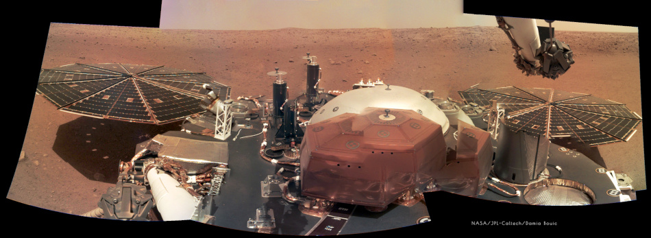
Using these images is going to be tricky - but not beyond our panorama experts, I'm sure. This is a preliminary attempt to work with what we have, and using bits of one image to mask out parts of the arm in another image. Very rough but I'm sure we will see better soon.

Phil

Click to view attachment
PaulH51
QUOTE (Phil Stooke @ Dec 7 2018, 03:59 PM) *
Very rough but I'm sure we will see better soon.

Looking good, better than my effort Phil smile.gif
Adam Hurcewicz
Here is my version of InSight panorama smile.gif

Click to view attachment
kenny
A lovely panorama, Phil, and gives us the first wider view of the location.
If we are indeed in one of the sand-filled crater hollows, as has been speculated, it looks like we are on the edge of it.
jamescanvin
My version of the sol 10 panorama.

sol10_pan by nivnac, on Flickr
Phil Stooke
Excellent work from everyone! I added the last image and made a circular version. North roughly at the top, as for all my circular projections.

Phil

Click to view attachment
atomoid
great image looking down at the lander pad plus another set of images 84 & 89 suitable for stereo. There seem to be some noticeable differences on a specific region of the solar array (rigth next to the glint, which seems larger in one image due to gain), it looks perhaps due to a patch of dust getting blown around, though i see nothing comparable on the deck, maybe just specular differences due to perspective, or perhaps even re-reflections of light reflected off the arm itself?
Click to view attachmentClick to view attachment
Hungry4info
The position of the arm (and consequently the camera) has moved between the two images. Whatever the solar panels are reflecting (the sky I guess), we're seeing it at a different angle. If we assume the solar panels aren't a perfectly flat reflective surface, that seems to me a sufficient explanation. Sort of like looking at the reflection of a kitchen light in a crumpled plastic bag.
climber
Mars’ « wind »: https://spacegate.cnes.fr/fr/insight-histor...u-vent-sur-mars
elakdawalla
I started a new thread for discussion of landing site localization and various views people here will likely be generating of the landing site.

Phil, I moved your post there. Once we get a good view of the workspace and you start mapping out activities, you might create a workspace thread that's akin to a route map thread.
HSchirmer
QUOTE (Phil Stooke @ Dec 7 2018, 06:59 PM) *
Excellent work from everyone! I added the last image and made a circular version. North roughly at the top, as for all my circular projections.

Phil
Click to view attachment


Is there a particular spherical viewer and settings you use with this format?

Or is this an "eyes are used to this" thing, like reflexively seeing 3d from cross-eyed stereo?
propguy
QUOTE (jamescanvin @ Dec 7 2018, 05:12 AM) *
My version of the sol 10 panorama.

sol10_pan by nivnac, on Flickr

Wonderful panorama from just a few photos. Saw a few images today (not sure why there seems to be a periodic delay on the raw image website, so days it is right in time with the download, some days it is delayed) that show the 3rd footpad and my cruise thrusters. The thruster closeout bracket (that was exposed to the entry flow and heating) is very discolored. Being a Titanium plate this took some high heating rates and the partial blue color must mean there was some free O in the upper atmosphere. If this does in fact present startling science (i doubt it since there should be free O in the upper atmosphere) then I respectfully rescind this conclusion I made since I am not at all a planetary scientist (just a humble engineer).

P.S. back before entry I had asked folks if they had any good idea for an EDL song. I received lots of great responses, but luckily that morning driving into work KBCO in Boulder played Under Pressure by David Bowie and Queen. Being one of may favorite songs I quickly decided that is the EDL song for InSight. Most of the team at work agreed (we were under pressure that day and once it hit the atmosphere InSight itself was under atmospheric pressure). Heard the song again today and it brought me right back to that day.
Phil Stooke
"Is there a particular spherical viewer and settings you use with this format?

Or is this an "eyes are used to this" thing, like reflexively seeing 3d from cross-eyed stereo? "

Sorry, HSchirmer, I am not sure what you mean. These circular projections I make are basically the same as standard polar projections except that I vary the radial scale a bit (making them more like a stereographic projection, rather than an orthographic). It's an ad hoc process but it gives an effect I find useful.

Phil

HSchirmer
QUOTE (HSchirmer)
Is there a particular spherical viewer and settings you use with this format?
Or is this an "eyes are used to this" thing, like reflexively seeing 3d from cross-eyed stereo?


QUOTE (Phil Stooke @ Dec 8 2018, 08:25 AM) *
I am not sure what you mean. These circular projections


Are you viewing your circular projection .jpgs as a "flat" image like we see below,
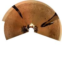
or are you using a panorama viewer that maps them onto a sphere, like Google Streetview, GoPro360, PhotoSphere?

I am curious because your polar images seem to be similar to many panaramas
but they are distorted when viewed with the panorama viewers I've tried.
Ant103
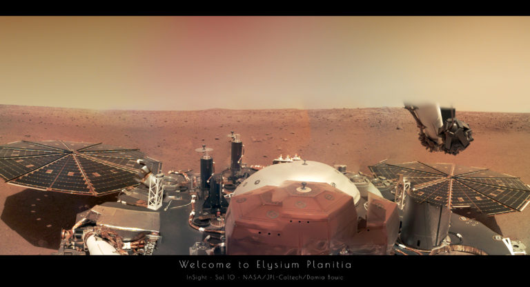
Very good work everyone on the last batch of IDC images smile.gif Really !

Here's my try :

Marcin600
Is this a very delicate impression of the high cirrus clouds in this picture?
https://mars.nasa.gov/insight-raw-images/su...0000_0550M_.PNG

Phil Stooke
HSchirmer - I only view them flat. The intention is to go from a panorama view to something approaching a flat map centred on the lander.

Phil

Phil Stooke
This is the same panorama data projected to show distant features better, and with a few annotations.

Phil

Click to view attachment
Ant103
I managed to make a postcard from the last panorama. It's always a bonus with some sky smile.gif

serpens
Phil's annotated [projection certainly provides a good indication of the extent of dust removal by the thrusters.
Paolo
raw images for Sol 12 are up!
jamescanvin
Some images down from sol 12.

Here is a 29 frame mosaic of the ground right next to the lander.

insight_sol12_work_vloume by nivnac, on Flickr
nprev
To my untrained eye that area looks as close to perfect for instrument placement as anyone could ever possibly hope for. smile.gif

Terrific mosaic, James!
neo56
A small rock (center of image) seems to have been moved by retrorockets during landing and it left a track behind it.
But another rock on top right corner has not moved... Too heavy? Too far from rockets?
I enhanced the contrast of the photo.
Click to view attachment
HSchirmer
QUOTE (neo56 @ Dec 10 2018, 12:14 PM) *
A small rock (center of image) seems to have been moved by retrorockets during landing and it left a track behind it.
But another rock on top right corner has not moved... Too heavy? Too far from rockets?
I enhanced the contrast of the photo.
Click to view attachment


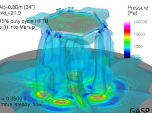
Probably a bit of both. I'd noticed that little "Beckham rock" with the bend in the path previously,
figured the path was a result of pressure falling off very quickly with distance from the plumes.
The simulations predict some "pressure ripples" outside the blue low-pressure tough, so we might see some rough-grain fine-grain patterns in the soil.


Does the insight team have a naming "theme" yet?
RoverDriver
QUOTE (neo56 @ Dec 10 2018, 04:14 AM) *
A small rock (center of image) seems to have been moved by retrorockets during landing and it left a track behind it.
But another rock on top right corner has not moved... Too heavy? Too far from rockets?
...


The (cosine of the) angle between the thrust vector and surface normal also plays a big role. That can make quite a difference.

Paolo
djellison
I had a quick go at generating a workspace model. It's incredibly flat. Pretty much the dream scenario for instrument deployment.

https://sketchfab.com/models/be1b893b28814b...9c35368b9508943

Fran Ontanaya
Just a regular speed turtle.
Phil Stooke
Propguy:

"Saw a few images today ... that show the 3rd footpad and my cruise thrusters."

Do we know which sol these were taken? I'm eager to see them.

Phil
Hungry4info
Is this not it from Sol 12?

https://mars.nasa.gov/insight-raw-images/su...0101_0060M_.PNG

Phil Stooke
I took that to be the second footpad. And no thrusters, or am I missing them?

Phil
mcaplinger
QUOTE (Phil Stooke @ Dec 10 2018, 04:54 PM) *
And no thrusters, or am I missing them?

I think the cruise thrusters are there on the left side.
PDP8E
I am intrigued by this land feature.
It looks like a rock(s) was pushed down an incline (by a dust devil maybe?) ??
Any ideas? This 'smooth slide' is something I've never seen...
(BTW...That distant hill is on the horizon right above it)

Click to view attachment

charborob
I am not convinced that it is a "slide". Could be just the way the rocks are placed that makes it look like it. Not enough resolution to be sure.
Phil Stooke
"I think the cruise thrusters are there on the left side."

Makes total sense now. I had been interpreting Propguy's comment as meaning there was an image looking under the lander, back to the other footpad and revealing the landing thrusters. Just call me too impatient!

Phil
John Moore
Is it possible to determine terrain detail from reflections in the instrument images posed (might add to the location controversy)?
PaulH51
some lovely sol 14 images down link

including this which shows a rather pointy rock close to one of the pads
Click to view attachment
This is a "lo-fi" version of our main content. To view the full version with more information, formatting and images, please click here.
Invision Power Board © 2001-2024 Invision Power Services, Inc.