Full Version: InSight Surface Operations
Pages: 1, 2, 3, 4, 5, 6, 7, 8, 9, 10, 11, 12, 13, 14, 15, 16, 17, 18, 19, 20, 21, 22, 23, 24, 25, 26
10 new images from Sol 20 are on the raw images page. SEIS has been grappled:
QUOTE (Zeehond @ Dec 18 2018, 04:25 AM) 
.....SEIS has been grappled
Looks like the operations schedule provided on the SEIS web page is being maintained:-
The critical deployment phase is split into six parts and could take up to two months after landing (with a margin of 20 sols). During this time, the teams will be constantly on hand, unlike during the scientific measurement phase, when the probe will be operating practically on its own. The operations schedule is given below:
Sols 0 - 5: initialization of the lander and preparation for instrument deployment.
Sols 6 - 18 : characterization by the cameras of the room available for positioning the instruments and selection of the most advantageous potential sites for deployment.
Sol 7 (science) : initiation of RISE data acquisition (geodesy).
Sols 19 - 31 : deployment of the SEIS seismometer (see details below). Start of measurements in engineering mode.
Sols 32 - 43 : deployment of the seismometers Wind and Thermal Shield (WTS). Start of SEIS scientific measurements (monitoring) from sol 40.
Sols 44 - 58 : deployment of the HP3 suite. Its mission accomplished, the robotic IDA returns to a stowed position on the lander.
Sols 59 - 69 : start of drilling operations with the HP3 mole.
Source links English French
Long time lurker here - have my contribution to the image processing with a fully room-scale walkabout VR version of InSight's landing site:
https://steamcommunity.com/sharedfiles/file.../?id=1593406277
Basically, I threw all the images into Agisoft PhotoScan and was surprised to get a pretty complete reconstruction of the landscape on one side of the lander. That, combined with some impostor geometry for the sky and terrain going out to the horizon meant a pretty immersive environment to wander around in. Add the lander model from NASA's 3D resources pages, and behold - Mars! (Elysium Planitia is so very flat, isn't it?)
I've posted notes for a more complicated version of my process in this older Curiosity scene here:
https://steamcommunity.com/sharedfiles/file...s/?id=928142301
(Full disclosure: I work at Valve on SteamVR, but I built this stuff because I'm a complete space nut. Hello!)
Some news from « sister » ForeSight, they seams to know where to land SEIS: https://www.seis-insight.eu/fr/actualites/4...-mars-sur-terre
QUOTE (climber @ Dec 18 2018, 12:58 PM)
Some news from « sister » ForeSight, they seams to know where to land SEIS: https://www.seis-insight.eu/fr/actualites/4...-mars-sur-terre
 That is amazing. Merci, vieil ami.
 Technology has come a long way since the MER test-bed.
its in French of course, but maybe this link will work for others too?
https://translate.google.com/translate?sl=f...-mars-sur-terre
being automated there are some real gems in there to start: "...extremely accurate digital terrain model, reproducing each terrain accident."
https://translate.google.com/translate?sl=f...-mars-sur-terre
being automated there are some real gems in there
to start: "...extremely accurate digital terrain model, reproducing each terrain accident."
The grapple is designed to grab, so it's impossible to lose grip.
To open they use a wax actuator.
https://www.nextgov.com/emerging-tech/2018/...-lander/152070/
To open they use a wax actuator.
https://www.nextgov.com/emerging-tech/2018/...-lander/152070/
QUOTE (atomoid @ Dec 19 2018, 04:24 AM)
its in French of course,
Hum, on the upper rigth side you can clic to get the english version
QUOTE (climber @ Dec 19 2018, 05:09 PM)
Hum, on the upper rigth side you can clic to get the english version
Selecting the English version takes me to the SEIS home page. (using my browser)
The link converts to English: link
I also resorted to google translate (which seemed excellent) after being unable to find the article after clicking through the Union Jack.
QUOTE (Cargo Cult @ Dec 18 2018, 02:55 AM)
Long time lurker here - have my contribution to the image processing with a fully room-scale walkabout VR version of InSight's landing site:
 This is amazing. Thank you so much!
QUOTE (Cargo Cult @ Dec 18 2018, 03:55 AM)
Long time lurker here - have my contribution to the image processing with a fully room-scale walkabout VR version of InSight's landing site:
https://steamcommunity.com/sharedfiles/file.../?id=1593406277
Basically, I threw all the images into Agisoft PhotoScan and was surprised to get a pretty complete reconstruction of the landscape on one side of the lander. That, combined with some impostor geometry for the sky and terrain going out to the horizon meant a pretty immersive environment to wander around in. Add the lander model from NASA's 3D resources pages, and behold - Mars! (Elysium Planitia is so very flat, isn't it?)
I've posted notes for a more complicated version of my process in this older Curiosity scene here:
https://steamcommunity.com/sharedfiles/file...s/?id=928142301
(Full disclosure: I work at Valve on SteamVR, but I built this stuff because I'm a complete space nut. Hello!)
Superbe! Great job, would love to see more panoramas portrayed in VR.
QUOTE (MarkL @ Dec 16 2018, 06:36 AM)
Any idea how the raw images are being named?
The naming convention is described in this document beginning on page 22.
Edit: I decided to make myself an explainer since I figured I'd continually forget the details about mesh and mosaic IDs.
Huge thanks for the image decoder cheat-sheet, Emily it is so helpful!! ..now i'm curious what the 'EDR' as well as the 'M' at the end represent.
I never was able to get Cargo Cult's walkabout VR version of InSight's landing site working, just brings up a simple image, perhaps i need SteamVR equipment or something like that?
Climber's 360 pano is an amazingly well curated mosaic, i finally feel what its like at the landing site now, thanks!
Im assuming the Seis site may only release news in French, as the english version simply lacks a 'News' (Actualités) link.
Regarding that wax-actuated grapple, I hadn't considered or read anywhere if it is capable as a sort of off-label use to pick up rocks, which was discussed somewhat earlier in this thread, but so far unsubstantiated, as a means for inducing vibrations (drop rocks by grapple or soil by bucket) at intervals which in conjunction with the Seis could perhaps stereo image the local subsurface environs to detect large subsurface rocks to avoid in order to better position deployment of the HP3..
QUOTE (atomoid @ Dec 20 2018, 02:37 AM)
i'm curious what the 'EDR' as well as the 'M' at the end represent.
Fairly sure EDR is "Experiment Data Record"
QUOTE (atomoid @ Dec 20 2018, 03:37 AM)
I never was able to get Cargo Cult's walkabout VR version of InSight's landing site working, just brings up a simple image, perhaps i need SteamVR equipment or something like that?
Yes you need VR equipment.
EDR, the Experiment Data Record, is the actual data from the spacecraft as received. It has not been calibrated, cleaned of noise or processed in any other way, and in the case of an image not map-projected (for instance, LRO Camera EDRs are often a mirror-image of the map-projected version, which causes new users no end of confusion). The original file for these InSight images is the EDR, and strictly speaking we are not getting that in the public release but it's what the science team have.
Phil
Phil
Congratulations to the team!!!!! Most significant mission milestone since touchdown!
animation of the deployment. the tether looks blurred in the frame after it releases from the deck
Click to view attachment
Click to view attachment
My take on the SEIS deployment GIF, I added the timestamps and brightened each of the sol 22 frames a little.
Click to view attachment
Click to view attachment
I thought the deployment would have been so much slower with stops at many locations to check things, looks like it was one smooth deployment movement.
I will just mention that I am working on a site map and will post it when I can.
Phil
Phil
Probably they figure that it is less risky to do the deployment in one (well practised) move, than leaving the instrument dangling on the tether for longer periods of time.
Congratulations to the team!
Congratulations to the team!
Seven Sol 23 images are down. The Grapple is still engaged on SEIS. Link to all Sol 23 images link
Click to view attachment
Click to view attachment
With instruments in the FOV, the dust on the camera really isn't as bad as it appeared with only dirt and gravel of the same hue in the FOV.
Also, it's funny to think back on this being called slow-ish. Seems like lightning speed!
Also, it's funny to think back on this being called slow-ish. Seems like lightning speed!
Wonderful news! And if it seems fast, it did take a whole Martian day to do this.
Judging from the press release, the heat flow probe will go on the far right of the work space to have as much distance from SEIS as possible? Seems a bit more rocky on that side though...
EDIT: nevermind looks like it will be on the left, actually, judging by this (https://twitter.com/NASAInSight/status/1075559676069048320) C was the final spot for SEIS, so HP3 might go around the H area.
I think the A or E areas are what is intended, based on the rendered images of deployed instruments.
Phil
Phil
Looking at the deployed Seismometer on the ground, one thing occurred to me. Wouldn't the flex-cable moving around in the wind impart some minor vibrations into the instrument? Are there any isolation mechanisms on the cable interface into the instrument that will help mitigate that?
good point, from the SEIS page:
"To avoid any vibrations transmitted through the tether from the lander (perhaps due to movement of the solar arrays when blown by the wind), damping devices have been installed.
One of the most important of these is a relaxation or service loop. A mechanical part attached to the seismometer forces the cable into a loop, which greatly reduces the potential propagation of waves from the spacecraft. This clever idea is commonly used on Earth when geophysicists deploy seismometers. Once the instrument is on the ground, it is generally recommended that the cable carrying power and data should be wound once around the seismometers protective cover.
Other subtle enhancements have gradually been added according to the project engineers inspiration. The tether, for instance, has been fitted with a small rod terminated by a small sphere allowing it to be grasped by the gripper at the end of the robotic arm. If the situation warrants it, it will therefore be possible to grab the cable on the ground and change its position.
A metal plate of roughly 300 g and fitted with prongs is also attached to the lower part of the cable; this tether prong mass will help to improve contact with the ground and prevent possible micro-movements."
QUOTE (James Sorenson @ Dec 20 2018, 02:19 PM)
Looking at the deployed Seismometer on the ground, one thing occurred to me. Wouldn't the flex-cable moving around in the wind impart some minor vibrations into the instrument? Are there any isolation mechanisms on the cable interface into the instrument that will help mitigate that?
Altitude 32 km. Think about wind.
QUOTE (atomoid @ Dec 20 2018, 11:47 AM)
...
One of the most important of these is a relaxation or service loop. A mechanical part attached to the seismometer forces the cable into a loop, which greatly reduces the potential propagation of waves from the spacecraft. This clever idea is commonly used on Earth when geophysicists deploy seismometers. Once the instrument is on the ground,...
One of the most important of these is a relaxation or service loop. A mechanical part attached to the seismometer forces the cable into a loop, which greatly reduces the potential propagation of waves from the spacecraft. This clever idea is commonly used on Earth when geophysicists deploy seismometers. Once the instrument is on the ground,...
This is also used by recording engineers when placing microphones on stands. Not only they put the mike on elastic suspension mounts but also add a service loop to avoid any (mechanical and electrical) noise that can be transmitted through the cable.
Paolo
QUOTE (ronatu @ Dec 20 2018, 11:52 AM)
Altitude 32 km. Think about wind.
Yes, and still vibrations were made of the solar panels flapping that were detected by the instrument on the lander. Parachutes have been seen in the past blowing over in the wind. A thin and light flex cable almost surely can still move and resonate in the wind.
Looking at this image:
https://mars.nasa.gov/resources/22231/fores...e/?site=insight
the cable is much lower than at the present with the weighted section on the ground. Presumably we will see some changes in the cable as they optimize things.
Phil
https://mars.nasa.gov/resources/22231/fores...e/?site=insight
the cable is much lower than at the present with the weighted section on the ground. Presumably we will see some changes in the cable as they optimize things.
Phil
In this image I am pretty sure that the TSB is open.
QUOTE (Phil Stooke @ Dec 21 2018, 01:20 AM)
Looking at this image:
https://mars.nasa.gov/resources/22231/fores...e/?site=insight
the cable is much lower than at the present with the weighted section on the ground. Presumably we will see some changes in the cable as they optimize things.
Phil
https://mars.nasa.gov/resources/22231/fores...e/?site=insight
the cable is much lower than at the present with the weighted section on the ground. Presumably we will see some changes in the cable as they optimize things.
Phil
QUOTE (atomoid @ Dec 20 2018, 03:37 AM)
Im assuming the Seis site may only release news in French, as the english version simply lacks a 'News' (Actualités) link.
Unfortunately we dont have the capability to release the SEIS news in French and English, and the news section is indeed lacking in the english version of the site. I assumed that English speakers would go to the NASA/JPL websites for news.
Welcome to UMSF, Pikaia!  We look forward to your insights about SEIS as the experiment proceeds.
Admin hat on: Fellow members, let's please remember that the InSight program, like all others, has hard constraints in time, money, and personnel; there's never enough of any of those things, so they will of course focus on accomplishing the mission above all else. They do not owe us anything whatsoever in terms of websites translated for our convenience or cookies before bedtime, for that matter. Please review the Rules and Guidelines, esp. rule 2.6.
Two posts hidden.
We look forward to your insights about SEIS as the experiment proceeds.Admin hat on: Fellow members, let's please remember that the InSight program, like all others, has hard constraints in time, money, and personnel; there's never enough of any of those things, so they will of course focus on accomplishing the mission above all else. They do not owe us anything whatsoever in terms of websites translated for our convenience or cookies before bedtime, for that matter. Please review the Rules and Guidelines, esp. rule 2.6.
Two posts hidden.
Currently, I don't have the time to translate the whole article. But maybe of primary interest for the the next weeks, the article says, that the SEIS instrument is far from its final state, yet. The instrument will be aligned horizontally. Then, they'll do some tests of the noise level transmitted through the tether, before they'll decide how to reduce it. They have several options for doing so, and they finally intend to unroll the tether completely from the tether storage box (TSB).
Handling the tether has been discussed already, above.
Handling the tether has been discussed already, above.
QUOTE (nprev @ Dec 21 2018, 01:33 PM)
... the InSight program, like all others, has hard constraints in time, money, and personnel; there's never enough of any of those things, so they will of course focus on accomplishing the mission above all else. They do not owe us anything whatsoever in terms of websites translated for our convenience ...
Two posts hidden.[/color]
Two posts hidden.[/color]
Translation is available online anyway, and members of this site might also have a crack at translations and post them here. It seems this is one of the many good things that can come from citizen scientists having a way to get involved such as is provided by unmannedspaceflight.com. Panoramas, traverse maps, animations and translations.
That said, proper outreach is vital for several reasons, not the least of which is to encourage strong public support of future missions. It's nice to play with fancy toys in a publicly funded sandbox but the quid pro quo for that is the understanding that common people have to work and earn money to pay the millions in taxes that fund these beautiful missions. So the public has a strong interest in knowing how their money is spent and will be more inclined to vote for future missions if they understand better why it is worth the money.
So I would say they do "owe" us this. But not at the expense of the mission itself, and right now everyone is pretty busy I think.
Mark
http://spaceref.com/mars/insight-places-a-...er-on-mars.html
There is a spaceref article about the seismometer deployment.
There is a spaceref article about the seismometer deployment.
I just noticed that this sol 18 image:
sol_0018_idc_D001R0018_598131636EDR_F0606_0010M_.PNG
looks so far under the lander that you can see the back footpad. It seems to be sitting on the surface, not buried or partly buried as the other two are. Several of the thruster-excavated pits under the lander are visible as well.
This is a cropped and rotated view of the area:
Click to view attachment
And this enlargement shows the footpad, identified by arrows:
Click to view attachment
Phil
Nice view of the thrusters and how firing change the color of their throats.
I suspect that rather than sinking the landing pads were covered by regolith excavated by the thrusters. The colour change in the pyramidal rock gives an indication of the depth/volume excavated.
QUOTE (Gerald @ Dec 21 2018, 08:20 PM)
Currently, I don't have the time to translate the whole article.
When translating the news, please make sure that you are always using the original page (don't use a previous copy). I sometimes update the text, to make the facts straight. Waiting a few days after the release could help. For this one, I updated the paragraph related to the arm motion, and then the paragraph about the tether operations (TSB will be open first then LSA - with cable displacement if needed -, and finally deployment of WTS).
i had made a stereo of that SOL18 set, but due to the crazy parallax wasn't compelled to post it, so i revisited it increasing the gamma, cropping and optimizing for the area beneath the deck so it comes out a little better to get a feel for the gouge mark depths, so seems worth posting in response, really get the sense a lot of regolith must have been blasted up against the lander body, so it seems no wonder that some managed to work its way behind the lens cap. unfortunately the footpad is itself obscured by the nozzle in one of the pair.
Click to view attachmentClick to view attachment
Regarding translation, its easiest to simply insert the below string in front of any URL you want to translate (in this case FR to EN):
Click to view attachmentClick to view attachment
Regarding translation, its easiest to simply insert the below string in front of any URL you want to translate (in this case FR to EN):
CODE
https://translate.google.com/translate?sl=fr&tl=en&u=
Here is a translation. Though I used Google for speed it then needs review and adjustments. It is a good and useful tool but still not good enough. I also attach a file with the translated text. The original page is here
Congratulations to the SEIS team!
Fernando
Click to view attachment
The second landing of SEIS seismometer
Posted on December 19, 2018.
The seismometer SEIS has just been successfully deposited on the surface of Mars by the probe InSight
NASA has successfully deposited the seismometer of the probe InSight on Mars. This is the first time in the history of space conquest that an instrument is deployed by a robotic arm on the surface of another planet. The success of this critical step for the rest of the mission is the result of years of unceasing technical efforts by the American, French and European teams.
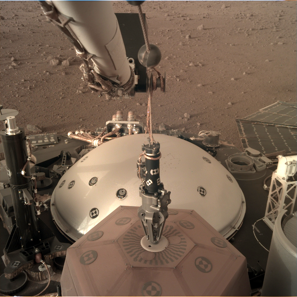
Photo 1 Legend: SEIS seismometer capture by the robotic arm grapple during sol 20 (© NASA / JPL)
The complex sequence of instructions commanding the deployment was sent yesterday (December 18, 2018 at 5:11 pm in California) to the red planet. At that moment, the probe InSight began its 22nd day of operations on the surface of Mars (it was then 5 o'clock in the morning on Elysium Planitia). For thermal considerations, the deployment was planned for the same day, but in the evening. On December 19, 2018, when the Sun had just disappeared behind the Martian horizon at 6:40 pm local time (while simultaneously rising in California on Los Angeles), InSight's arm went into action to place the 9,5 kg of the SEIS seismometer on the ground. For this high-risk operation, the instrument was completely powered off. Many tests have been previously done on Earth to validate the orders, the landing site having been faithfully reproduced for the occasion.
The automatic sequence actually started on Mars at 17:00 with the subsequent firing of the three frangibolts that kept SEIS securely attached to the probe deck. To carry out the deployment of the seismometer itself, the engineers had decided to wait a little, so that the IDA robot arm was cold enough: the latter is actually more efficient at low temperatures. Activation of the deployment sequence was therefore scheduled for 18:30, or ten minutes before the sunset on Mars.
To place SEIS on the ground, the robotic arm has performed a fairly complex series of movements. After lifting the 25 centimeter instrument vertically, the arm moved back to pull the cable off the deck, the latter being held by several velcro fasteners. He then made a 180° rotation on itself, before going forward again to continue tearing the velcro. The arm then stretched as far as possible to the south to remove the part of the cord attached to the outside of the TSB (the cylindrical case where the SEIS cable is wound), again with a velcro patch. This step inevitably induces a somewhat intimidating swing of SEIS at the end of the grapple. For the last part of the sequence, the arm goes back slightly towards the lander, then, thanks to arc movements, it gently places SEIS on the ground. The sequence did not provide for the opening of the grapple. This stage, which will mark the definitive release of the instrument, is planned in the coming days.
Photo 2 Legend: Image from the ICC camera showing SEIS seismometer on the ground just before sunset (© NASA / JPL)
The duration of the deployment sequence itself is quite short: only 10 minutes. The need to acquire images via the ICC camera (located under the deck) and the IDC camera (mounted on the arm), however, took the duration of the operation to about 20 minutes, spread over 45 minutes. The time at which the SEIS seismometer planted its three feet in the sand is estimated at 7:05 (in California), which is 18:54 Martian time.
In view of the night planning chosen for the deployment, the first Martian orbiter capable of relaying to Earth the data confirming the emplacement of SEIS on the ground could be in position only on 19 December in the evening (ie the beginning of the morning of sol 23 on Mars). A first X-band transmission around 6:00 pm had already given the deployment team a number of subtle indications that operations were running smoothly. But it was not until the overflight by Mars Odyssey at 9:00 pm (California time) that the images, absolutely beautiful, finally appeared on the screens of the control room at JPL. Between sending orders to the red planet and receiving the first telemetry data, the engineers had, thus, to wait 24 hours. A long wait punctuated with doubt and worry, given the complexity of the maneuver involved and the interests a stake.
The area where SEIS now rests is directly in front of the robotic arm (to ensure that the umbilical cord connecting the instrument to the undercarriage rests flat on the ground), and as far away as possible (1,65 meters) from the probe, so as to minimize disturbances. The speed with which the engineers and geologists chose this placement site is related to the appropriateness of the area where the probe landed on November 26th. With a very small slope (only 2 to 3 degrees of inclination) and a striking absence of pebbles, almost all of the terrain located south of the lander and within reach of the robotic arm was suitable for the deployment of the seismometer.
Photo 3 Legend: The SEIS seismometer of the InSight probe, as seen by the robotic arm's IDC camera, after its deployment during sol 22 (© NASA / JPL).
Operations are however far from being completed for SEIS. Many critical steps must now take place in the coming weeks before scientists can start tracking down Martian quakes. Engineers will actually first have to align the seismometer with the horizontal, thanks to the motorized leveling cradle. Once this step is completed, sensors for the very wide band (VBB), inactive for the moment, contrary to the short period sensors SP, will be refocused and calibrated. The totality of the data transmitted by the six seismic sensors will then be used to characterize the noise level of the emplacement site (which should be as low as possible), as well as the level of disturbances induced by the cable connecting the instrument to the lander.
When performance is deemed acceptable, the cable in the TSB unwinder will be fully unwound. If the engineers notice that the cable is injecting too much noise into the instrument the pyrotechnic opening of the service loop (LSA) will be performed. Depending on the result of this step, the cable may possibly be re-positioned using a hook located on a pinning mass. The final placement, over the instrument, of the imposing WTS wind and thermal protection shield can then take place.
As we can see, on Earth and on the Red Planet, engineers and scientists still have a lot of work to do before the first Mars geophysical station is fully operational. But the emplacement of the first seismometer on Mars is already a great success, that the members of the team will celebrate with according dignity, probably by allowing themselves a few days of rest for the Christmas holidays!
Pasadena, 19 December 2018 (update of the paragraphs concerning arm movements and subsequent operations on 20 and 21 December)
Congratulations to the SEIS team!
Fernando
Click to view attachment
The second landing of SEIS seismometer
Posted on December 19, 2018.
The seismometer SEIS has just been successfully deposited on the surface of Mars by the probe InSight
NASA has successfully deposited the seismometer of the probe InSight on Mars. This is the first time in the history of space conquest that an instrument is deployed by a robotic arm on the surface of another planet. The success of this critical step for the rest of the mission is the result of years of unceasing technical efforts by the American, French and European teams.
Photo 1 Legend: SEIS seismometer capture by the robotic arm grapple during sol 20 (© NASA / JPL)
The complex sequence of instructions commanding the deployment was sent yesterday (December 18, 2018 at 5:11 pm in California) to the red planet. At that moment, the probe InSight began its 22nd day of operations on the surface of Mars (it was then 5 o'clock in the morning on Elysium Planitia). For thermal considerations, the deployment was planned for the same day, but in the evening. On December 19, 2018, when the Sun had just disappeared behind the Martian horizon at 6:40 pm local time (while simultaneously rising in California on Los Angeles), InSight's arm went into action to place the 9,5 kg of the SEIS seismometer on the ground. For this high-risk operation, the instrument was completely powered off. Many tests have been previously done on Earth to validate the orders, the landing site having been faithfully reproduced for the occasion.
The automatic sequence actually started on Mars at 17:00 with the subsequent firing of the three frangibolts that kept SEIS securely attached to the probe deck. To carry out the deployment of the seismometer itself, the engineers had decided to wait a little, so that the IDA robot arm was cold enough: the latter is actually more efficient at low temperatures. Activation of the deployment sequence was therefore scheduled for 18:30, or ten minutes before the sunset on Mars.
To place SEIS on the ground, the robotic arm has performed a fairly complex series of movements. After lifting the 25 centimeter instrument vertically, the arm moved back to pull the cable off the deck, the latter being held by several velcro fasteners. He then made a 180° rotation on itself, before going forward again to continue tearing the velcro. The arm then stretched as far as possible to the south to remove the part of the cord attached to the outside of the TSB (the cylindrical case where the SEIS cable is wound), again with a velcro patch. This step inevitably induces a somewhat intimidating swing of SEIS at the end of the grapple. For the last part of the sequence, the arm goes back slightly towards the lander, then, thanks to arc movements, it gently places SEIS on the ground. The sequence did not provide for the opening of the grapple. This stage, which will mark the definitive release of the instrument, is planned in the coming days.
Photo 2 Legend: Image from the ICC camera showing SEIS seismometer on the ground just before sunset (© NASA / JPL)
The duration of the deployment sequence itself is quite short: only 10 minutes. The need to acquire images via the ICC camera (located under the deck) and the IDC camera (mounted on the arm), however, took the duration of the operation to about 20 minutes, spread over 45 minutes. The time at which the SEIS seismometer planted its three feet in the sand is estimated at 7:05 (in California), which is 18:54 Martian time.
In view of the night planning chosen for the deployment, the first Martian orbiter capable of relaying to Earth the data confirming the emplacement of SEIS on the ground could be in position only on 19 December in the evening (ie the beginning of the morning of sol 23 on Mars). A first X-band transmission around 6:00 pm had already given the deployment team a number of subtle indications that operations were running smoothly. But it was not until the overflight by Mars Odyssey at 9:00 pm (California time) that the images, absolutely beautiful, finally appeared on the screens of the control room at JPL. Between sending orders to the red planet and receiving the first telemetry data, the engineers had, thus, to wait 24 hours. A long wait punctuated with doubt and worry, given the complexity of the maneuver involved and the interests a stake.
The area where SEIS now rests is directly in front of the robotic arm (to ensure that the umbilical cord connecting the instrument to the undercarriage rests flat on the ground), and as far away as possible (1,65 meters) from the probe, so as to minimize disturbances. The speed with which the engineers and geologists chose this placement site is related to the appropriateness of the area where the probe landed on November 26th. With a very small slope (only 2 to 3 degrees of inclination) and a striking absence of pebbles, almost all of the terrain located south of the lander and within reach of the robotic arm was suitable for the deployment of the seismometer.
Photo 3 Legend: The SEIS seismometer of the InSight probe, as seen by the robotic arm's IDC camera, after its deployment during sol 22 (© NASA / JPL).
Operations are however far from being completed for SEIS. Many critical steps must now take place in the coming weeks before scientists can start tracking down Martian quakes. Engineers will actually first have to align the seismometer with the horizontal, thanks to the motorized leveling cradle. Once this step is completed, sensors for the very wide band (VBB), inactive for the moment, contrary to the short period sensors SP, will be refocused and calibrated. The totality of the data transmitted by the six seismic sensors will then be used to characterize the noise level of the emplacement site (which should be as low as possible), as well as the level of disturbances induced by the cable connecting the instrument to the lander.
When performance is deemed acceptable, the cable in the TSB unwinder will be fully unwound. If the engineers notice that the cable is injecting too much noise into the instrument the pyrotechnic opening of the service loop (LSA) will be performed. Depending on the result of this step, the cable may possibly be re-positioned using a hook located on a pinning mass. The final placement, over the instrument, of the imposing WTS wind and thermal protection shield can then take place.
As we can see, on Earth and on the Red Planet, engineers and scientists still have a lot of work to do before the first Mars geophysical station is fully operational. But the emplacement of the first seismometer on Mars is already a great success, that the members of the team will celebrate with according dignity, probably by allowing themselves a few days of rest for the Christmas holidays!
Pasadena, 19 December 2018 (update of the paragraphs concerning arm movements and subsequent operations on 20 and 21 December)
Serpens: "I suspect that rather than sinking the landing pads were covered by regolith excavated by the thrusters."
I think that's a very good point!
Phil
I think that's a very good point!
Phil
I cannot find it again but I red, may be somewhere in french, that 2 feet sank and not the 3rd so the vehicule is tilted 4 degres in the arm side direction. Could be consistent with Phils thoughts then.
I will try to run some traduction but not sure my english is good enough
Will be during 3 months or so, then Ill have 2 years to recover anyway
Will be during 3 months or so, then Ill have 2 years to recover anyway
This is a "lo-fi" version of our main content. To view the full version with more information, formatting and images, please click here.