May be I'm too excited but, I think I can see an entrance into Victoria.
If you look around, all entrances don't look too steep but look very sandy...so we may be cannot get out.
Except this one, were it's may be paved the way Endurance was paved :
Click to view attachment
"By-product" : lot of boulders may be reachable from there.
OK, a lot of "may be" but I just can't sit and watch without thinking with all these new views.
Full Version: Final Approach
QUOTE (climber @ Sep 26 2006, 08:20 PM) 
Am I alone there? Help please don't let me down! Pancams are there...eho eho eho !!!!
...
The horizontal (now white) line seams much smaller than I first thought but I think the bigger part is around Sofi and we don't see it yet on the pancam.
...
The horizontal (now white) line seams much smaller than I first thought but I think the bigger part is around Sofi and we don't see it yet on the pancam.
No climber, you are not alone. Probably we have now too many informations to elaborate...

These PanCam images are so different from previous ones because we are looking through L7 filter, in the blue/violet. At this wavelenght, we do not see the outcrops but details are stunning, especially the boulders and the horizon features (look at the twin peaks now!).
I was making the same considerations about the horizontal line, now so bright. This clear discontinuity is clearly made of a completely different stuff and I start to understand why capes abruptly ends when intersecating it.
I think terrain is much less cohesive below this layer, so terrain tends to slide under action of gravity in absence of other material around it. Probably, immediately after VC formation, rim was pretty circular but then started to be eroded in correspondance of bays. First colapsed leaving the big chunk, then aeolian erosion did the work producing boulders and, at the end, sand.
What do you think?
I think James labels around Victoria are the best the JPL ones seem a bit bitty.
The view is brilliant massive boulders.
Roy F
ps I've just seen climbers post and that entrance point looks good, quite a bit to see and the slope looks good taking into account that at this distance the slope looks steeper than it actually is. does any one have the angle on this slope?
The view is brilliant massive boulders.
Roy F
ps I've just seen climbers post and that entrance point looks good, quite a bit to see and the slope looks good taking into account that at this distance the slope looks steeper than it actually is. does any one have the angle on this slope?
QUOTE (volcanopele @ Sep 26 2006, 08:28 PM)
Maybe this has been discussed earlier, but in these latest pancams, there appears to be a thin bright layer a few meters below the crater rim. Any thoughts on this?
I believe there is something similar to the line feature at Endurance. (I got pretty excited about it a few days ago, until that was pointed out to me. Still, no doubt it's illuminating in some way that it's there.)
Here's a crude Pancam anaglyph:

QUOTE (dilo @ Sep 26 2006, 10:41 PM)
I think terrain is much less cohesive below this layer, so terrain tends to slide under action of gravity in absence of other material around it. Probably, immediately after VC formation, rim was pretty circular but then started to be eroded in correspondance of bays. First colapsed leaving the big chunk, then aeolian erosion did the work producing boulders and, at the end, sand.
What do you think?
What do you think?
Make sense. I also notice that what I once called "caves", some are visible in today's pancam, are located right on the white layer and seams to go a little bit down the layer as well as above the layer. No explanation.
First R1/L7 image set, Titan lakes, second R1/L7 image set. Happy hours.
Absolutely stunning L7/R1 anaglyph view of Cabo Verde:
Click to view attachment
That's the slope up to the beacon on the far left.
Click to view attachment
That's the slope up to the beacon on the far left.
QUOTE (mhoward @ Sep 26 2006, 10:42 AM)
I believe there is something similar to the line feature at Endurance. (I got pretty excited about it a few days ago, until that was pointed out to me. Still, no doubt it's illuminating in some way that it's there.)
Preliminary guess: I think this may correspond to the light-toned upper unit ("Interdune/Playa - Festoon Cross lamination Wavy Bedding Translatent Strata") that Grotzinger et al. described at Endurance Crater.
QUOTE (climber @ Sep 26 2006, 10:41 AM)
May be I'm too excited but, I think I can see an entrance into Victoria.
 I'm sure you could rappel down it on a rope, Climb, but Oppy forgot his mountaineering gear!
QUOTE (Shaka @ Sep 26 2006, 10:58 PM)
I'm sure you could rappel down it on a rope, Climb, but Oppy forgot his mountaineering gear! FredK made some slope measurments on another bay.
Can you do this one for us, FredK?
Here's a pancam version of my navcam anaglyph of Cabo Frio:
Click to view attachment
Frio is the ridge jutting in from the right and in 3D you can see it's between the foreground and the far rim.
Click to view attachment
Frio is the ridge jutting in from the right and in 3D you can see it's between the foreground and the far rim.
QUOTE (Shaka @ Sep 26 2006, 08:58 PM)
I'm sure you could rappel down it on a rope, Climb, but Oppy forgot his mountaineering gear! They are already geared up, IMHO. These things are robot mountain goats

What they don't like, of course, is sand...
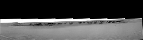
110x30 cylindrical projection of Pancam L7:
QUOTE (mhoward @ Sep 26 2006, 11:13 PM)
110x30 cylindrical projection of Pancam L7:
This one at maximum size is just, just, THE best.
Thanks so much Mike.
QUOTE (mhoward @ Sep 26 2006, 11:06 PM)
These things are robot mountain goats
What they don't like, of course, is sand...
What they don't like, of course, is sand...
Just like me
QUOTE (climber @ Sep 26 2006, 09:24 PM)
This one at maximum size is just, just, THE best.
Thanks so much Mike.
Thanks so much Mike.
I'm not entirely sure why I'm bothering, since JPL will probably post a better version tonight. Still, you saw it here first

Anaglyph version:

QUOTE (climber @ Sep 26 2006, 09:24 PM)
This one at maximum size is just, just, THE best.
Seconded, outstanding work Mike, one of my fave images from the whole mission so far.
Just got back from work and found I missed the grand unveiling of all the pancams... but don't feel too bad because scrolling through the previous 4 or so pages has revealed some stunning work from you guys - anaglyphs, mosaics, just so many wonderful images. So, thanks everyone for taking the time, and having the patience, to make such images and share them with all us non-experts - and we really should say thanks again to Doug for giving us this incredible meeting place for sharing this experience.
Going to go drool over the raw pancams now...
"What a mess...this town's in tatters...I've been shattered...my brain's been battered...splattered all over...Manhattan"...Jagger/Richards, "Shattered"
Quite unsuprisingly, the bedrock walls of Victoria show evidence of intense brittle deformation. Other than the intriguing double white line near the rim, there are only a few features that show anything vaguely like stratal geometry...at least at this range.
Hopefully when we get to the rim, we will we see if we can pick out relict strata through the tatters of the battering, splattering and shattering...
(sha-dooby...)
Am I the only one getting a bit of a touch of vertigo. I had thought that we were going to be underwhelmed by Victoria but its abundantly clear that I was mistaken. At this stage though I'm not sure if that's a good thing as the potential entry ramps really do seem to be treacherously steep.
I had thought that we were going to be underwhelmed by Victoria but its abundantly clear that I was mistaken. At this stage though I'm not sure if that's a good thing as the potential entry ramps really do seem to be treacherously steep.
I know that it appears at the present that the entrance ramps on the far rim appear to be sandy. How much of that appearance is due to the fact that we're 1 km away from those ramps? Would we be able to resolve firmer ground from this distance?
Stu says:
"That's a joke, right? I mean, you're not really suggesting I can't tell Mars from Venus...
That was colourised v quickly from yesterday's pancams. Hope there's better today... "
Stu, it was indeed a joke. Maybe too deadpan without a wee smiley
Sorry Stu, our exchange is interspersed with pages of the exciting stuff .. which is phenomenal, by the way. Are people noticing the fissures on the rim in the Cabo Frio direction? Sort of like the arcuate rim cracks that appear near volcanic craters, or the slump separation of a snow cornice (although obviously in vastly different material from both those).
Kenny
I know I'm getting some vertigo. I can't wait 'till Oppy drives out on one of these capes, and if we are able to drive down one of these bays eventually, it surely will be the most amazing imagery from the mission so far.
Also can't wait to see some synthetic images with Opportunity put in for scale...
Also can't wait to see some synthetic images with Opportunity put in for scale...
Here is the distorted MOC image alongside mhowards pancam mosaic.
Click to view attachment
Amazing views!
James
Click to view attachment
Amazing views!
James
It must be the zoom on the camera. But, VC appears to be about the size of Endurance. It looks like you could throw a rock across. I'm sure they'll use some different magnifications and give a more accuarte view tomorrow or the next sol.
The apparant size is very deceptive, IMO, as I've noted before, perhaps because the air (what there is of it) is unnaturally clear by terrestrial standards. I think it's getting more obvious already how big this thing is, though. Go back and look at the version with fredk's mystery men for a sense of scale... or maybe fredk will do a new one
QUOTE (mhoward @ Sep 26 2006, 04:38 PM)
Anaglyph version:
Mike
Very professional picture. It looks great.
I see the slumps even clearer of every bays are very tough or impossible to climb back but they are only drivable only for down.
Rodolfo
QUOTE (helvick @ Sep 26 2006, 04:45 PM)
At this stage though I'm not sure if that's a good thing as the potential entry ramps really do seem to be treacherously steep.
Going down, these ramp aren't a problem! Driving a sandy ramp down is very easy and very safe. I have done this with my truck on slopes of between 25-30 degree, driving very slow, without using brake but using the engine brack by the gear 4x4Low. But, but, it is only one way ticket for Oppy....
Rodolfo
P.S. When I am back home, I will put a picture.
Click to view attachment
This slope has about 80 meters height. The surface is very sandy. Never break wheels but just keep running the wheels as slow as possible. Similarly Oppy can go down like it but she will never be able to get back.
QUOTE (jamescanvin @ Sep 26 2006, 05:02 PM)
Here is the distorted MOC image alongside mhowards pancam mosaic.
Click to view attachment
Amazing views!
James
Click to view attachment
Amazing views!
James
Perfect matching! No doubt to select which ones you like most!

Rodolfo
QUOTE (gregp1962 @ Sep 26 2006, 11:03 PM)
I'm sure they'll use some different magnifications and give a more accuarte view tomorrow or the next sol.
There is no option to use a "different magnification" the cameras all have a fixed FOV and "magnification". The problem here is that we are looking out across terrain where we have _no_ visual clues for scale and the optical clarity of the atmosphere at the moment (Tau at around 0.3 ) is as good if not better than the clearest of days on earth.
QUOTE (helvick @ Sep 26 2006, 10:22 PM)
There is no option to use a "different magnification" the cameras all have a fixed FOV and "magnification". The problem here is that we are looking out across terrain where we have _no_ visual clues for scale and the optical clarity of the atmosphere at the moment (Tau at around 0.3 ) is as good if not better than the clearest of days on earth.
Well, maybe when we can see more inside of the crater, we'll have a much better scale reference.
Does it look like we'll move closer tomorrow?
You can tell its bigger, a similar view of Endurance took only 3 pancam frames, Victoria from proberbly a little further away, takes 8 frames.
wow I've missed a few pages while I was sleeping  can't seem to get rid of a cold I got and I fell asleep..
The L7's are amazing, nice pans Michael!!
The view is indeed 'somewhat' more overwhelming than back at Endurance...I'm going to sit back now and enjoy the view some more
Nico
can't seem to get rid of a cold I got and I fell asleep..The L7's are amazing, nice pans Michael!!
The view is indeed 'somewhat' more overwhelming than back at Endurance...I'm going to sit back now and enjoy the view some more
Nico
sol 950 L7 + sol 948 L2:

Just a teaser.
Just a teaser.
QUOTE (Nix @ Sep 26 2006, 10:46 PM)
wow I've missed a few pages while I was sleeping can't seem to get rid of a cold I got and I fell asleep..
can't seem to get rid of a cold I got and I fell asleep..Funny, I have a cold as well... it's the only reason I've home home gawking at Pancams and generating pans all day
Edit: plus I'm slightly incoherent, apparantly.
Is there any word on whether or not we'll get closer tomorrow?
Thanks for that colour view, Horton! I was just thinking we could combine the L7's and L1's into 2 channel colour. Did you have to rescale one of the channels to account for the move towards Vicky?
QUOTE (gregp1962 @ Sep 26 2006, 10:57 PM)
Is there any word on whether or not we'll get closer tomorrow?
Looks like
QUOTE
4. What EDRs did we request?
Expected EDRs by sequence number and image type:
Sol Seq.Ver ETH ESF EDN EFF ERP Tot Description
--- -------- --- --- --- --- --- ---- -----------
951 p0673.03 6 0 0 6 0 12 navcam_3x1_az_126_3_bpp
951 p1151.04 2 0 0 2 0 4 front_hazcam_idd_unstow_doc
951 p1154.01 2 0 0 2 0 4 front_hazcam_idd_unstow_doc
951 p1201.06 2 0 0 2 0 4 front_haz_penultimate_1bpp_pri34
951 p1212.09 2 0 0 2 0 4 front_haz_ultimate_2_bpp_pri15
951 p1275.01 2 0 0 2 0 4 front_hazcam_0.5bpp_pri_41
951 p1301.05 2 0 0 2 0 4 rear_haz_penultimate_1bpp_pri34
951 p1311.07 2 0 0 2 0 4 rear_haz_ultimate_1_bpp_crit15
951 p1375.01 2 0 0 2 0 4 rear_hazcam_0.5bpp_pri_41
951 p2619.08 57 2 0 0 3 62 pancam_skysurvhi_L2345678R345678
951 Total 79 2 0 22 3 106
Its now sol early morning on sol 951 - we might see new images tomorrow about the same time as today, I imagine, if we're lucky.
QUOTE (hortonheardawho @ Sep 26 2006, 10:49 PM)
sol 950 L7 + sol 948 L2:
Just a teaser.
Just a teaser.
Beautiful!
What is incredible is that we are seeing approximately half of true crater extention, based on this official scheme!
"Cape0" seems the best place where to snap a full panorama, because is the most elevated point...
QUOTE (kenny @ Sep 26 2006, 09:56 PM)
Are people noticing the fissures on the rim in the Cabo Frio direction? Sort of like the arcuate rim cracks that appear near volcanic craters, or the slump separation of a snow cornice (although obviously in vastly different material from both those).
No! Could you point these fissures out on an image?
Indian3000: thanks for passing on the leaked images!

We're going to have fun here
Yes Marco -the complete extension of the crater below the local horizon is remarkable
Nico
I bet that each one of those visible outcroppings is about the size of Burn's Cliff.
QUOTE (Jeff7 @ Sep 27 2006, 12:36 AM)
I bet that each one of those visible outcroppings is about the size of Burn's Cliff.
They will be bigger than Burns Cliff, remember they are 800 meters away, at least 75 feet high.
Man...just gotta say that since reaching adulthood in the 80s I've always been a little bummed by the fact that I'll never get to personally walk on Mars. This terrific mission as well as the incredible imagery that our most learned UMSFers produce have removed this feeling...I have seen the unknown, and it's every bit as wonderous and awe-inspiring as I imagined it. My deepest thanks to you all.
QUOTE (Jeff7 @ Sep 27 2006, 12:36 AM)
I bet that each one of those visible outcroppings is about the size of Burn's Cliff.
I'd take that bet! They're bigger; even the smallest Vicky cape is way bigger than Burns. Here's Nico's pancam pan with Endurance stuck in so it appears at the same scale as the far rim:
Click to view attachment
QUOTE (dilo @ Sep 26 2006, 06:25 PM)
Beautiful!
"Cape0" seems the best place where to snap a full panorama, because is the most elevated point...
"Cape0" seems the best place where to snap a full panorama, because is the most elevated point...
Yes sure, hope that the Cap0 has a solid surface ramp so Oppy can go to tip on that like a surfing on Mars.
Rodolfo
Great comparison Fred. Burns cliff is totally insignificant beside any Victoria cliff.
Maybe Burns should be demoted to a "dwarf cliff"?
James
Maybe Burns should be demoted to a "dwarf cliff"?
James
Yeah, maybe James. I suppose that would depend on whether Burns cleared its neighbourhood of debris? 
Great pans and analglyphs. Thanks for the hard work. It may be a perspective thing, but it looks like the cape on the left which rises up slightly (is this the beacon people have been mentioning?) is way way above the plain to the south. Kind of like Pride Rock. That would be a most righteous spot for a giant pan. It is remarkably unflat. But the terrain is just gorgeous to look at, especially in these near UV wavelengths.
Given there'll be a drop of approximately 70m over a horizontal distance of 125-175m going in to Vic, the average slope of any bay will be from ~22 to ~30 degrees. Because of the concavity of the path to the bottom, the slopes will be significantly greater near the rim. Many of these look like 45 degree slopes over the first/uppermost few metres. It'll be a challenge to find a route out. Lots of switchbacks could perhaps get her out, but the lip (where slope should be steepest) will be a tricky obstacle.
Should be some big excitement tomorrow. Perhaps we'll see the south edge of the dunefield and fuller expanse of the far rim.
Some quick and dirty trig helps to figure out how much of the outcrop we see across the way (old news to the veterans here no doubt). You can calculate the height of the outcrop if you know the distance to it and the angle it subtends (ie. covers) in the pancam image. Each pixel of a pancam image subtends 0.0164 degrees. Count the pixel height of any feature you know the distance to, multiply by 0.0164, take the sin of that, then multiply by distance and you have the height of the feature. I make the current outcrop we see to be about 45 pixels high and (based on the consensus) 800m distant so:
45 pixels x 0.0164 degree/pixel = 0.738 deg.
sin(0.738) = 0.01289
800m x 0.01289 = 10.3m high
Here is the Excel spreadsheet that does the math for you: Click to view attachment
<Had to edit this due to fup in wording. doh.>
This is a "lo-fi" version of our main content. To view the full version with more information, formatting and images, please click here.