Help - Search - Members - Calendar
Full Version: Final Approach
Unmanned Spaceflight.com > Mars & Missions > Past and Future > MER > Opportunity
Pages: 1, 2, 3, 4, 5, 6, 7, 8, 9, 10, 11, 12, 13, 14, 15
Aberdeenastro
QUOTE (jamescanvin @ Sep 20 2006, 03:33 AM) *
Here is the far rim in JPL's navcam image compared with a 'straightened' far rim from orbit.

Click to view attachment

James

EDIT: Replaced with a slightly modified version


James,

That's a great piece of image work. Much neater than my earlier very quick attempt:

http://www.unmannedspaceflight.com/index.p...ost&p=68491

Castor
Tesheiner
QUOTE (climber @ Sep 19 2006, 10:22 PM) *
To put things in perspective, this remind me of Ordessa (Spain) :
View 100 m from the "rim" :
Click to view attachment
View from "Cape Verde" :
Click to view attachment
Imagine we'll have the same contrast in a few days smile.gif


I'm expecting a *BIG* scene when we get to the exact rim, but not like Ordessa.
That would be too much for the heart. cool.gif

OT: I was flying back from Frankfurt to Madrid two weeks ago, there was an absolutely clear sky and we crossed the Pirenees right by Gavarnie and Ordessa. Huge!
fredk
Here's a contrast-boosted, 2x vertical stretched crop from the jpl navcam pan:
Click to view attachment
It shows the beacon outcrop quite clearly, and another feature that I've been curious about - the "sluffing slab". To me it looks like it may be a piece of the plains outside the rim that has detached and started sluffing into the crater. The orbital imagery doesn't have the resolution to show the slab clearly.
ljk4-1
-quote in reply removed-

If you use your imagination, it looks like the debris in front of the Beacon
is actually an arrow on the ground pointing to the slab, as if it were put there
as a ramp so Opportunity could enter Victoria safely.
JRehling
QUOTE (stevesliva @ Sep 19 2006, 11:04 AM) *
You have me imagining an amazing view from the far side.


Yes, it looks like the far side would present an easier entrance (if any) and a more expansive view.

It's interesting how clear the view across is. Not, obviously, as clear as long-range views on the Moon, but much less obscured than a summer post-dust storm sol. Spring was a good season to arrive. When it comes time to look north and perform TES of the north interior rim, I hope things are still as clear.
JRehling
QUOTE (jamescanvin @ Sep 19 2006, 09:34 PM) *
Justin Maki of NASA's Jet Propulsion Laboratory, Pasadena, Calif., an imaging scientist on the rover team. "However, we still have another two or three short drives before Opportunity is really right at the rim, looking down into the crater."


Time to put away the driver and take out the putter.
MahFL
Yes but I have seen pro's with a putter hit the ball wayyyyyy past the hole...........
Phil Stooke
http://qt.exploratorium.edu/mars/opportuni...cam/2006-09-20/

Pancams are on the ground...

Phil
Nix
ALL RIGHT!! Let's get to it, they look ohmy.gif jaw dropping that is..

Nico biggrin.gif
mhoward
Yowzers. I've updated the MMB metadata. I'll have time to generate some pans in an hour or so (unless somebody wants to use the 1.5 'Export Pan Images and PTGui Project File..' feature...)
jvandriel
The view in the drive direction.

Taken with the L2 pancam on Sol 944.

jvandriel
gregp1962
WOW!!! It's sureal sitting here among a bunch of people in the office that barely care about this stuff, and, wouldn't know a thing about it if I hadn't been telling them. (They feign interest for my sake) My wife pokes fun at me, claiming that the only reason for my interest is her claim that Mars is MY home planet and Venus is HERS. My counterclaim is that Earth is my home planet and Venus (or Mercury)is hers.

Yet, there a bunch of people that I've never met, (You all) who share my fascination with Mars.

I'm dying to see a stitch of these images.

http://qt.exploratorium.edu/mars/opportuni...cam/2006-09-20/
Pando
Wow...! A nice view of Sofi as well!

http://qt.exploratorium.edu/mars/opportuni...00P2382L2M1.JPG
algorimancer
Here's a full-sized pancam panorama, just a quickie with no pretty anti-vignetting like in jvandriel's version:

http://www.clarkandersen.com/pano.jpg

I love that nice line of horizontal stratum.
algorimancer
QUOTE (Pando @ Sep 20 2006, 01:09 PM) *
Wow...! A nice view of Sofi as well!


Wow indeed. I hadn't expect it to look like a crater from this far away. Cool.
Gray
How much forshortening are we seeing here? Those rock exposures are looking pretty inaccessible to me. sad.gif
RNeuhaus
Today new pictures have given me new toughts.

The only part that we can see the stratas are the upper side but nothing on the lower which are covered by sand. mad.gif The lower part is the part most desired to know. sad.gif

The other good comment is that the promontory is impressive and it belongs to near rim. That picture has confirmed about its position. smile.gif

Lately, at the back of VC, on the west side, there are at least three hills: twin peaks, and one of a similar size of Columbia ones (I think so since I have no made parallex calculations on that). Anyone can tell us about its height.

Rodolfo
imipak
Oppy: "Hey, this rock..."
JPL: "Er, evaporite."
Oppy: "Evaporite... yeah."
JPL: "Er, dust-covered evaporite."
Oppy: "Yeah,.. it's slippery as, as, as - what's the slipperiest thing you can think of?"
JPL: "At this moment? This evaporite."
Oppy : "Right. This evaporite is as slippery as this evaporite."


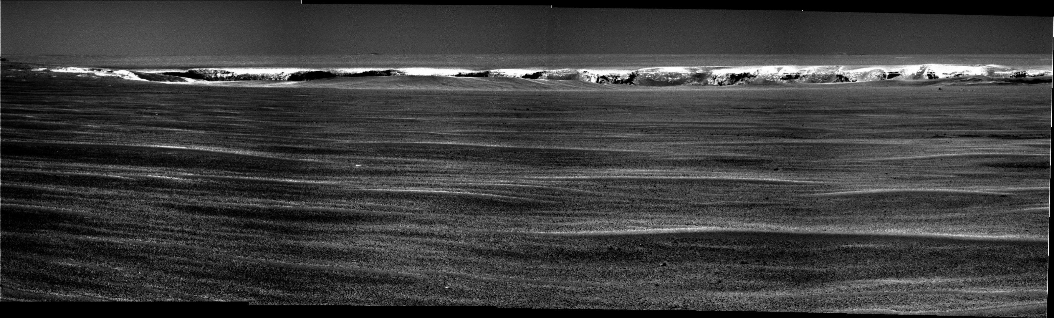
A lot of nice detail visible in the pancams, in particular there's a nice thick white (well, brighter at that particular wavelength) stripe visible, eg:here

It seems to significantly inclined relative to the surface, too, by perhaps 25 degrees -- would any of the rockhounds care to speculate about whether that's an artifact of the impact 'peeling back' the upper layers of the surface, or a pre-existing feature before the impact? ie., could it reflect the incline of the rest of the layers we've passed out on the plains?

The "sluffing slab" looks to me like the edge of the ramp^w alcove. I picture a wedge-shaped chunk of the surface sliding down into the crater; at the edges of the wedge, softer material on the non-moving side of the fracture would erode more quickly, and the 'cap' of evaporite has eventually snapped off and slid laterally as well as down slope somewhat.

However the alcoves visible on the far side appear to be composed of much smaller fragments than anything you could call a slab, sheet or a plate - a field of boulders, eg 
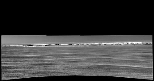
here

I'm quite glad we've got a few days whilst the VxWorks spods kick the metaphorical tyres of the new software load. Once we get up on whichever promontory and start the big pan, I suspect there's going to be a firehose of amazing features...
Marz
QUOTE (RNeuhaus @ Sep 20 2006, 01:21 PM) *
Today new pictures have given me new toughts. ....


Whoa! ohmy.gif [theme song to "2001" plays in background]

Considering the far rim is ~800m away, that's some awesome rim! The amount of slumping on the rim and debris below has, as RNuehaus expressed, disconcerting. I hope there are some lower strata that are visible, and dare I dream, approachable. I wonder how recent some of the slumping events were? [gulp!]

I saw those hills far out on that horizon... and already had the explorer's curse too: how far away are they? what lurks over there!? Let's go!! Should we start placing bets when Oppy will reach them? tongue.gif
gregp1962
I haven't been able to find a satellite view that includes those far away hills. Does anyone know where one is?
Myran
QUOTE
RNeuhaus wrote: The only part that we can see the stratas are the upper side but nothing on the lower which are covered by sand. The lower part is the part most desired to know.


You might be correct in thinking so, and if things turn out to be so that would be so sad with all this work and no result when we've finally reached the goal.
But lets hope that our rover can study at least one or two more pieces of geological strata here that show some intermediate age not revealed in Endurance - at least I hope for something of that kind.
Floyd
QUOTE (RNeuhaus @ Sep 20 2006, 02:21 PM) *
The only part that we can see the stratas are the upper side but nothing on the lower which are covered by sand. mad.gif The lower part is the part most desired to know. sad.gif


In orbital images, the eastern side of VC is very sandy up through the ramps. The 'boat ramp' and the large SW ramp seem to have rock quite a ways down.

Time to get a labeled map of VC so we can be a bit more precise. tongue.gif
Nix


A first look in stereo..'cleaned'-up version coming up biggrin.gif

What a view what a view, congratulations to the team for making this happen..awesome!

Nico
NoVi
Wow, new 20 september pancam and navcam pictures online on exploratorium!!
Nirgal
QUOTE (Nix @ Sep 20 2006, 09:05 PM) *
A first look in stereo..'cleaned'-up version coming up biggrin.gif

What a view what a view, congratulations to the team for making this happen..awesome!

Nico


ohmy.gif ohmy.gif
Nico, a big thank-you for your phantastic and ULTRA-fast smile.gif image work accompany our
final-approach-party !
Nix
previous one was co-registered, this one 'normal';


Nico
Nix
Exciting times ahead Nirgal -I hope we get some color soon smile.gif
RNeuhaus
I wish that the next time that Oppy take a PANCAM on Promontory. It is a impressive rock. That rock seems to be the product of the Victoria Crater impact and it does not belong to the Meridiani Planum as it is almost completely flat around that zone. It seems that Oppy is still about 70-80 meters away from the tip!

Rodolfo
Nirgal
Quick question: when is Oppy expected to be out of restricted sols again ?
mhoward
The anaglyphs are fantastic, Nico ... the second one in particular really gives me a better sense of the scale of what we're looking at. Which is, in a word: BIG.

58x32 degree perspective projection:
Bill Harris
I imagine that the restricted sols would be linked to the current solar conjunction: 7Oct-8Nov 06. They might go off for the last few days to secure Oppy but I'd expect them to go on full days after the conjunction.

Fairly nice stratigraphy in the first view of the bluffs of Victoria. These exposures will be an opportunity to examine lateral changes in the evaporite.

--Bill
Nirgal
QUOTE (Bill Harris @ Sep 20 2006, 09:59 PM) *
I imagine that the restricted sols would be linked to the current solar conjunction: 7Oct-8Nov 06. They might go off for the last few days to secure Oppy but I'd expect them to go on full days after the conjunction.

--Bill


now I'm a bit confused ... I thought that each restricted sol period lasts about two weeks (?)
so I thought (hoped) that Oppy would be out of the current restricted period very soon ...
climber
Thanks Nico, I'm one anaglyph lover,so, I'm what, happy? Well, may be more.
Have you notice the "leveled" line that goes all the way from the left to the right, not visible in the Bays but clearly visible on the cliffs. It tells us something but I wonder what. At least, if we can see it so clearly from this distance, it has to be quite a big feature, in the order of 1-2 meters. Could it be the original rock before the impact that formed VC ?
fredk
Yikes, incredible stuff. The navcam crop showing beacon and "sluffing slab" I posted above has been superceeded by this pancam frame (incase anyone looked at the L2 frames alone).

Beacon at far left, towering above Victoria and drawing in all travellers for kms around (well, one traveller at least!), and "sluffing slab" looking like, well, like a sluffing slab! laugh.gif
mhoward
Here is the complete Sol 943 Navcam pan in both cylindrical and equirectangular formats

Cylindrical:


Equirectangular:
climber
Well, did I spot the first caves on Mars?
Sofi cater can be seen here and the caves are on the left into the Cliffs. Probably more caves are visible on the same level on other Cliffs.
Corrected with arrows
Click to view attachment
Much more evident that these are big holes in Nico's anaglyph. Some one see the same?
Tesheiner
Wow! This new pancams are what I was waiting for a loooong time. cool.gif

Nirgal: I thought (hoped) that Oppy would be out of the current restricted period very soon ...

It would be the case if the pics were downlinked at the proper time, but given the current DSN issues and the late arrival of images, what happens is that the restricted sols period is somehow extended.

Fredk: The navcam crop showing beacon and "sluffing slab" I posted above has been superceeded by this pancam frame (incase anyone looked at the L2 frames alone).

I'm one of those! I downloaded all L2 pics and said to myself: "Damn, the beacon is just off to the left. If we had another additional frame...". Just forgot that right-lens pancams points 2º leftwards.
BTW, nice work with that previous contrast-enhanced image; the outcrops and the near-rim contour are very well defined.
RNeuhaus
QUOTE (climber @ Sep 20 2006, 03:37 PM) *
Well, did I spot the first caves on Mars?
Sofi cater can be seen here and the caves are on the left into the Cliffs. Probably more caves are visible on the same level on other Cliffs.
Corrected with arrows
Click to view attachment
Much more evident that these are big holes in Nico's anaglyph. Some one see the same?

I don't think the spoted alcoves have caves. These might most probably be the result of light shade. Next wait for the next hops! wheel.gif

Rodolfo
mhoward
Sol 943 combined Navcam/Pancam equirectangular:


Big version
Nirgal
here are a few first color attempts (not easy with those first noisy over-stretched pancam JPGs ...

unfortunately there seem to be problems with my web space provider right now so I'm trying to
provide the images as forum attachment:

Click to view attachment
Marz
QUOTE (RNeuhaus @ Sep 20 2006, 03:53 PM) *
I don't think the spoted alcoves have caves. These might most probably be the result of light shade. Next wait for the next hops! wheel.gif

Rodolfo


Climber!!! Now I'm gonna be silly dreaming of martian caverns until we get proper lighting on those shadows. Did ustrax put you up to this? laugh.gif

Seriously, it doesn't seem implausable given the readily soluable evaporite layers and percolating groundwater that there might be solution cavities somewhere in the strata. But didn't Victoria's impact happen after ALL evaporite layers had formed, and so the groundwater was already gone? If so, then you'd think the impact shock would've destoyed any pre-existing features as delicate as a cave?
MaxSt
Boring plains for months, then BAM! Amazing...

Oppy spent 220 sols investigating half of Endurance, looks like not even 880 sols will be enough for Victoria.
dilo
In this PanCa festival, this post can appear obsolete...
Anyway, I used the official released NavCam stitch to create this stretched, colored version:
Click to view attachment
some work was done in order to uniform the pictures uniformity, local/overal contrast and sharpening (sky is artificial).
Nirgal
and those are based on a fine de-vignetted b/w version done by Marco (dilo) on the released JPL navcam-pano:

Click to view attachment

note, that the usual false-color-warning disclaimer applies of course wink.gif

EDIT:
oops: Marco, you beat me on the second to it wink.gif wink.gif
Nix
QUOTE (RNeuhaus @ Sep 20 2006, 10:53 PM) *
I don't think the spoted alcoves have caves. These might most probably be the result of light shade. Next wait for the next hops! wheel.gif

Rodolfo


The data is clipped so don't get any hopes up for caves, although perhaps there will be small cavities between large boulders on the rim.

Nice colors Nirgal! smile.gif

edit; woaw -more color, great work.

Nico
Shaka
QUOTE (climber @ Sep 20 2006, 10:07 AM) *
snip...
Have you notice the "leveled" line that goes all the way from the left to the right, not visible in the Bays but clearly visible on the cliffs. It tells us something but I wonder what. ....snip... Could it be the original rock before the impact that formed VC ?

How wonderfully intuitive you are, Climb! I salute you, mon ami, for you have focused on the first great discovery to be made at Victoria. (Let's hope there will be many more!) That "levelled line" proves beyond doubt that the present surface layers of evaporite in this area of Meridiani were laid down AFTER the VC impact formed the crater, its ejecta blanket and raised rim were eroded away, and the crater was filled with material.

Since the 'blueberry' concretions in these layers must have formed AFTER the surface sandstones were laid down and saturated with acidic water during Mars' "Wet Period", the Victoria impact must have happened BEFORE the Wet Period. If we accept the many arguments the professionals have produced to show that the Wet Period was a very long time ago (i.e. over 3 billion years ago), then we can conclude that Victoria Crater is older than that. ohmy.gif (Wow. Not bad for a "levelled line", eh?)

I hear a few skeptics in the "Young Victoria" Club clearing their throats to ask why the level surface stratum could not have formed before the VC impact? I answer that, if that were so, the stratum would no longer be level. The huge energy of the impact would have shattered and tumbled the evaporite far beyond its original rim. Remember little Beagle Crater? No two chunks of adjacent evaporite had the same orientation; they were more-or-less randomly jumbled. So Beagle formed after the evaporite was deposited. Victoria formed before.

I think it must be the mountaineer in you, Climber, who instantly realised that a level depositional stratum and a violently disruptive event like mountain building (or impact cratering) are not consistent. Beau geste!
Ant103
I have a bit late but it was time to show my processings biggrin.gif

There is two images, an anaglyph and a simple view :


And my page for those who understand french wink.gif.
...

I have the impression to have forgeted some thing...

Ow!

WHAT A GREAT VIEW!!! ohmy.gif ohmy.gif ohmy.gif And it's a very small part of the future and incredible view we will see in a short time.

Hail Victoria!
mhoward
A cylindrical projection:
marswiggle
QUOTE (gregp1962 @ Sep 20 2006, 06:49 PM) *
I haven't been able to find a satellite view that includes those far away hills. Does anyone know where one is?

Link(s) to MEX image here
http://www.unmannedspaceflight.com/index.p...c=2653&st=0
and here cropped images with directions.
http://www.unmannedspaceflight.com/index.p...3056&st=570

I just realized that this already mentioned single pancam frame includes three craters totally dissimilar to each other - Viccy, Sofi and the Far Big One - or four, if the little hole just at the fore edge of Vic on the right is one - or five, if the vast depression beyond Vic is an eons old paleocrater (speculative). One of the best shots by Oppy so far, in any case.
jamescanvin
QUOTE (gregp1962 @ Sep 21 2006, 04:49 AM) *
I haven't been able to find a satellite view that includes those far away hills. Does anyone know where one is?


We talked about this when it first appeared -

http://www.unmannedspaceflight.com/index.p...ost&p=66819

http://www.unmannedspaceflight.com/index.p...ost&p=66855

Some people doubt we can see that far, but it's nowhere near as far as the Gusev rim is from Spirit and it's midwinter when the atmosphere should be at it's clearest.

James

EDIT: Oops, Cross Post.
This is a "lo-fi" version of our main content. To view the full version with more information, formatting and images, please click here.
Invision Power Board © 2001-2024 Invision Power Services, Inc.