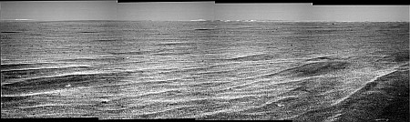
Sol 917 drive direction pan
Click to view attachment
James
Full Version: Victoria here we come...
That is some flat surface ahead of the rover. No wonder they're making excellent progress towards Victoria. And imagine that some here thought the apron would be very difficult to negotiate. 

The Epsilon crater has some bowl surrounded by the outcrop. Its size is about the half of Beagle crater. It would be very interesting to visit here and see if there are some differences between them. Then next, comes another crater, the buried ones with some dark sand: Zeta which would be rather bigger than Beagle crater. I am curious to find out why the buried Zeta crater has a dark sand?
The Oppy is sprinting that way and I am afraid the arrival time on Epsilon crater would be between 2-3 days!!
Rodolfo
The Oppy is sprinting that way and I am afraid the arrival time on Epsilon crater would be between 2-3 days!!
Rodolfo
Actually, there is a small chance we could arrive at Epsilon tomorrosol.
Sol 917 equirectangular:

Also, finished the Sol 916 Navcam pan.
QUOTE (jamescanvin @ Aug 23 2006, 06:34 PM) 
Good anaglyph, James! Gives me a very good sense of perspective. And I notice that a lot of the little pits I thought I could see in the MOC image are really there. The ones I can see don't look deep enough to trap a rover, though...

-the other Doug
I am YOL (yet another lurker) who checks up on the excellent work done here everyday. Hats off to you guys.
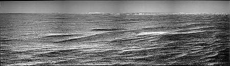
I was enjoying peering at the new 'glyphs posted today and I think I can see the raised rim of Zeta emerging behing Epsilon - kind of a soft rise most obvious to the left and behind the nearer crater. Does anyone else agree?
I have a question about what could be causing the really rough looking terrain to the far left of the pans. It looks like far away montains or rising broken evoporite with no dunes or white dunes. I can't see anything on the maps from above that explains it.
QUOTE (BEHSTeacher @ Aug 24 2006, 12:27 PM)
I was enjoying peering at the new 'glyphs posted today and I think I can see the raised rim of Zeta emerging behing Epsilon - kind of a soft rise most obvious to the left and behind the nearer crater. Does anyone else agree?
I think I see what you mean - could be Zeta, but if I stare off into the distance for long enough my eyes start to play tricks on me.

QUOTE (BEHSTeacher @ Aug 24 2006, 12:27 PM)
I have a question about what could be causing the really rough looking terrain to the far left of the pans. It looks like far away montains or rising broken evoporite with no dunes or white dunes. I can't see anything on the maps from above that explains it.
You mean the far right? The left looks smooth enough for a game a billiards!
I think the bright rough looking bit on the right horizon is caused by the changes in the way the ground reflects the sunlight at differing angles across distant ripples. Look at how bright the far sides of the nearby ripples look, imagine how these would look if they were further away. (and remember that these images probably have the contrast turned *way* up as a consequence of the raw image stretching)
A couple of versions of the 917 half pan posted by mhoward.
The more extreme stretch shows the pattern of reatures around the crater ahead quite well.
Phil
Click to view attachment
Click to view attachment
The more extreme stretch shows the pattern of reatures around the crater ahead quite well.
Phil
Click to view attachment
Click to view attachment
BEHSTeacher: I think that feature to the left and behind Epsilon can only be Zeta. It appears that we've been climbing slightly, and it is now emerging into view. As for the other feature, if you really meant "right" as James observed, I wanted to think it was the the SW rim of Victoria. It's dificult to discern in the flat images, but there is definitely something rough and above the local horizon from about 160 degrees south and all the way to the edge of the pancams. I can believe 160 degrees, but 170 seems like it should be off of the crater. 
QUOTE (Nirgal @ Aug 23 2006, 05:04 PM)
does anyone know the reason for the comparatively poor quality of the navcam and pancam images
lately ?
Those infrared filters have suddenly become very hard on the eyes since we left the ripples mostly behind. I know the drivers liked those filters for navigating the layered drifts, but I was kind of hoping they'd go back to L7R1 now that the ripples are no threat.
lately ?
QUOTE (jamescanvin @ Aug 23 2006, 05:47 PM)
Do any of these bright features at the rim correspond direction-wise to the feature we identified so long ago it seems as The Beacon? That is, do they sit at the spot on the near rim where the beacon is currently indicated on the MOC image?
Brian
QUOTE (BrianL @ Aug 24 2006, 02:08 PM)
Do any of these bright features at the rim correspond direction-wise to the feature we identified so long ago it seems as The Beacon? That is, do they sit at the spot on the near rim where the beacon is currently indicated on the MOC image?
No I don't think so.
A rough calculation puts the beacon at about 111 degrees and the left most edge of the drive direction pan at 115 degrees. - *Just* off the edge.
James
I think this is the beacon
Click to view attachment
A contrast/brightness enhanced version of this navcam image
James
Click to view attachment
A contrast/brightness enhanced version of this navcam image
James
QUOTE (BrianL @ Aug 24 2006, 06:08 AM)
Do any of these bright features at the rim correspond direction-wise to the feature we identified so long ago it seems as The Beacon? That is, do they sit at the spot on the near rim where the beacon is currently indicated on the MOC image?
I agree with James; the beacon is outside the fov.
What I see on 917 pancams is a new (near) rim feature just peaking up.
Compare this sol 917 pancam frame with the one taken on the previous sol and looking on the same direction.
Interesting phenomenon. As we approach The Beacon we are seeing rim features that weren't evident during the initial sighting. It seems that we should have seen them from a distance, too. We'll eventually figure out the geometry of this effect.
In the meantime, I'd like to hint at The Suits in Ithaca that we adopt an "Alice in Wonderland" naming convention once we reach The Beacon locale.
--Bill
In the meantime, I'd like to hint at The Suits in Ithaca that we adopt an "Alice in Wonderland" naming convention once we reach The Beacon locale.
--Bill
Here is the complete 360 degree panoramic view from Sol 916.
Taken with the L0 navcam.
jvandriel
Taken with the L0 navcam.
jvandriel
Now that we're approaching VC I've been wondering where would be the best place to hit the rim. I'm assuming that we will be paying a fleeting visit to the Epsilon crater on the way. Tesheiner's route map shows his suggested arrival at one of the entry gullies. However, i don't think this would give a good vantage point from which to survey the crater (especially the northern rim) and plan Opportunity's next steps.
I've attached a map (thanks to Tesheiner for the base) showing where I would go for. The green X marks the spot. This location would allow us to survey several of the entry options.
Click to view attachment
Any thoughts?
Castor
I've attached a map (thanks to Tesheiner for the base) showing where I would go for. The green X marks the spot. This location would allow us to survey several of the entry options.
Click to view attachment
Any thoughts?
Castor
Planned sequences on the PCDT web for sol 918 include a 360º albedo panorama, a 180º back-looking navcam mosaic, mini-TES activity, but NO driving.
I hope to be wrong but given the late time in which yestersol "drive-direction" pancams were downlinked it seems it was too late to include driving activity on tosol's plan. We'll see...
I hope to be wrong but given the late time in which yestersol "drive-direction" pancams were downlinked it seems it was too late to include driving activity on tosol's plan. We'll see...
QUOTE (Castor @ Aug 24 2006, 05:18 PM)
Any thoughts?
Yup.
I thought the same in a first glance (actually I preferred the promontory where the beacon is [still hypotetically] located in my map). But then I thought they won't risk to drive the rover over such a promontory without knowing what, if anything, is below it specially at the exact rim.
So I still bet for that entry ramp at the end of the hypotetical path.
918's not a driver, but I imagine 919 will be.
Two big drive sols...I think a rest sol is justified, recharge...downlink - always a good idea.
I'd really really like to see a single L456 of the tracks heading NNW from here....I guess one albedo frame may get them in - but they're downsampled anyway
Doug
Two big drive sols...I think a rest sol is justified, recharge...downlink - always a good idea.
I'd really really like to see a single L456 of the tracks heading NNW from here....I guess one albedo frame may get them in - but they're downsampled anyway
Doug
I would expect two full pans of the crater interior before any entry - one probably just beyond Epsilon, maybe the second from the nice ramp north of it. Also, a bit of arm work on the rim top outcrops at each place. Two pans will be necessary for long baseline stereoscopic viewing of the interior. Then it's a matter of searching for a good place to get into the stratigraphy in one of the wall alcoves.
Phil
Phil
Just to clarify my last words.
I think they'll head to the entry ramp ... to take the first 360º big panorama (L257, L7 in LOCO).
My take for the second panorama, before attempting any move into the crater, is at the promontory to the left (north). These two positions are separated by more then 100m, more then enough for long baseline stereo.
Oh - I wouldn't be suprisied to see an Endurance like treatment of the place...get VERY long baseline...600m or so. A pan from where we first arrive, and another one from 120 degrees around the crater to be sure of getting good imagery of all sides of the interior. Who knows - perhaps take a couple of months to do 240 degrees around the place, get three pans done, and then think about coming in from the western edge - or drive the full 360 and come back in from the North.
We know the surrounding terrain to be very navigable after all
Doug
We know the surrounding terrain to be very navigable after all
Doug
QUOTE (Tesheiner @ Aug 24 2006, 04:39 PM)
Just to clarify my last words.
I think they'll head to the entry ramp ... to take the first 360º big panorama (L257, L7 in LOCO).
My take for the second panorama, before attempting any move into the crater, is at the promontory to the left (north). These two positions are separated by more then 100m, more then enough for long baseline stereo.
I think they'll head to the entry ramp ... to take the first 360º big panorama (L257, L7 in LOCO).
My take for the second panorama, before attempting any move into the crater, is at the promontory to the left (north). These two positions are separated by more then 100m, more then enough for long baseline stereo.
The problem with a 360 panorama from that entry ramp may be that you can't see any of the northern rim. I could be wrong, but looking at the orbital image it appears that the northern rim around to about the 2 o'clock position will be hidden (sorry - I clipped the eastern edge of your image by mistake).
I'd go for a drive up my green X promontory, taking some baseline stereo along the edge between your entry ramp and the promontory itself.
Castor
Yes, sure - as the JPL philosophy, when MER arrives to an unknown interesting place such as the Eagle Crater, Columbia Memorial Station, Endurance, and Top of Hill Columbia, they make a full map of photographies as a recognition of new place before to decide where to explore. Now, for Victoria Crater will be also applied. So we are going to wait for long time for the next Oppy move around Victoria Crater.
The idea to climb to a Promontory. It would be good as the last step, in order to have a much better Meridiani panorama picture, before leaving Victoria Crater if the way access is feasible.
Rodolfo
The idea to climb to a Promontory. It would be good as the last step, in order to have a much better Meridiani panorama picture, before leaving Victoria Crater if the way access is feasible.
Rodolfo
I expect they will head for the closest point on the rim. The easiest place to enter appears to be at 11 o'clock. I wouldn't expect them to enter there this close to the solstice since it would leave Oppy tilted to the south. They will probably do a couple of panoramas first and survey part of the rim, drive to the 8 o'clock position perhaps, to determine the best way in.
Some new data about sol 918 already hit the PCDT web.
Confirmed; tosol is/was a rest day, for the wheels at least.
Confirmed; tosol is/was a rest day, for the wheels at least.
QUOTE (jamescanvin @ Aug 23 2006, 10:49 PM)
I think I see what you mean - could be Zeta, but if I stare off into the distance for long enough my eyes start to play tricks on me.
You mean the far right? The left looks smooth enough for a game a billiards!
I think the bright rough looking bit on the right horizon is caused by the changes in the way the ground reflects the sunlight at differing angles across distant ripples. Look at how bright the far sides of the nearby ripples look, imagine how these would look if they were further away. (and remember that these images probably have the contrast turned *way* up as a consequence of the raw image stretching)
Yes, I got left and right reversed -
So it could just be a mirage effect then? It did have a look of the optical illusion of pillars near the horizon on earth.
hint at The Suits in Ithaca that we adopt an "Alice in Wonderland" naming convention once we reach The Beacon locale
Hear hear!!
BTW, am I right in thinking that Victoria is the first feature we've (er, the Rovers have) encountered that had a preexisting name?
Unfortunately not- Victoria was named by the MER team, according to their scheme of naming craters after vessels of exploration (Victoria was Magellan's circumnavigating ship).
John.
John.
Nice picture mhoward 
I've a question : what are those strange lines at the top of the pano?
My own pictures of the last 2 sols :
Sol 916 pancam pano :
Sol 917 (always pancam) :
And a very short animated gif of the approach (sol 916 to 917) :
Click to view attachment
I want to say : go victoria!!

I've a question : what are those strange lines at the top of the pano?
My own pictures of the last 2 sols :
Sol 916 pancam pano :

Sol 917 (always pancam
) :
And a very short animated gif of the approach (sol 916 to 917) :
Click to view attachment
I want to say : go victoria!!
QUOTE (Ant103 @ Aug 24 2006, 11:17 PM)
I've a question : what are those strange lines at the top of the pano?
Compass points and a caption. If you view it in a spherical viewer like FSPViewer and pan all the way up, you can read the text.
Okay mhoward
And a polar projection made with Mars Rover Center Polar Transform (or MRCPT) :
QUOTE (jvandriel @ Aug 24 2006, 03:27 PM)
Here is the complete 360 degree panoramic view from Sol 916.
Taken with the L0 navcam.
jvandriel
Taken with the L0 navcam.
jvandriel
And a polar projection made with Mars Rover Center Polar Transform (or MRCPT) :
Here are two versions of the full 917 pan by mhoward in polar form. Look at the polygonal pattern of markings in the less exaggerated one (left). Strange!
Phil
Click to view attachment Click to view attachment
Phil
Click to view attachment Click to view attachment
I'm loving the excitement building up to the Victoria Crater encounter -- this is going to be spectacular.
QUOTE (john_s @ Aug 25 2006, 07:59 AM)
Victoria was named by the MER team, according to their scheme of naming craters after vessels of exploration (Victoria was Magellan's circumnavigating ship).
Indeed.
While were on the subject, I wonder if some of the small craters on the apron will be named after the other ships that set out with Victoria on the circumnavigation: the Trinidad (Magellan's flagship), the San Antonio, the Concepción and the Santiago.
QUOTE (Phil Stooke @ Aug 25 2006, 03:45 AM)
Look at the polygonal pattern of markings in the less exaggerated one (left). Strange!
Yes, Phil... this pattern is very strange and somehow familiar.
I tried to better highlight it and...WOW!
Click to view attachmentI see a winged ant heating rover tracks! Perhaps a martian insect which is menacing us telling is forbidden go to Victoria? Do "ant103" knows something that do not want to tell us?
(sorry for the bmp format, I know some of you cannot read but I'm not using my PC and cannot attach TIFFs/JPEGs)
Yes, It's forbiden to go to Victoria because it's my city 
But, where do you see any insect on the polar pan (without the lines you draw)?
So, it's a little strange this sort of polygonal on the horizon...
But, where do you see any insect on the polar pan (without the lines you draw)?
So, it's a little strange this sort of polygonal on the horizon...
QUOTE (Ant103 @ Aug 25 2006, 10:23 AM)
But, where do you see any insect on the polar pan (without the lines you draw)?
At the beginning I saw an elephant, but looking more carefully the insect shape above the rover is pretty evident to me...
OK, I know is totally subjective (like see a face in a a cloud) but was so funny, especially thinking to possible relation to your nickname and your last Terragen work!!!
Seriously, I think this pattern reflects the underlyng outcrop structure... very good catch, Phil! (I must to recall it when I will be able to make again vertical projections!)
Try this animated gif.
Oh! It's right, I see clearly a head and thehalf body of a sort of ant.
I'm on Mars, hurray!

It's right, I see clearly a head and thehalf body of a sort of ant. I'm on Mars, hurray!
Someone had better call Erich von Däniken. This could be big.
Tosol (919) images are available.
Here is a gamma-corrected image showing the trench made by the forward-right wheel.
Click to view attachment
Original: http://nasa.exploratorium.edu/mars/opportu...8ZP1214L0M1.JPG
Edited: And what's that on the rhaz images? A bug on the navigation sw?
http://nasa.exploratorium.edu/mars/opportu...8ZP1311R0M1.JPG
That wasn't a long drive... 
Well, next week is gonna be exciting!
Well, next week is gonna be exciting!
What has happened with so many crossing tracks? Looks like that Oppy is somewhat lost or looking for any special? At the end, seems that Oppy has changed its southeast direction to East...
http://qt.exploratorium.edu/mars/opportuni...8ZP1311R0M1.JPG
P.D.
Oops, I have just seen the Thesheiner picture to be the same case.
Maybe Oppy is doing for 3 things:
http://qt.exploratorium.edu/mars/opportuni...8ZP1311R0M1.JPG
P.D.
Oops, I have just seen the Thesheiner picture to be the same case.
Maybe Oppy is doing for 3 things:
- Trying to dig the surface with one of the wheels.
- Position of the best azimuth for communications purposes
- Changing the direction to Victoria
This is a "lo-fi" version of our main content. To view the full version with more information, formatting and images, please click here.