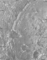
We had a drive up to the outcrop on sol 238. This site is on the other side of the ridge called Martre from the last abrasion at Bastide.
Phil
Click to view attachment
Full Version: Perseverance Route Map
A small adjustment to the position on sol 239. Perseverance is now sitting at the base of the outcrop imaged on sol 238 (before the sol 238 drive, so at the sol 237 location) and shown here by Tau. But the rover is facing away from the outcrop at the moment.
Phil
Click to view attachment
Phil
Click to view attachment
I have added Ingenuity's flight 15. It landed a little north of the targeted site. I am assuming it will be called Airfield F again.
Phil
Click to view attachment
Phil
Click to view attachment
I have added Supercam names from PDS to one of the earlier maps. I will update others as I can get to them.
Phil
Click to view attachment
Phil
Click to view attachment
Perseverance has started its return journey to the landing site (presumably), and to reduce clutter and confusion in the maps I will make a separate map for the return journey, both for the rover and for Ingenuity. This map is updated to sol 279 for the rover and omits the last two return flights of Ingenuity. The next map will follow both of them.
I modified the straight line flight of Ingenuity on sol 163 based on my own mapping of Ingenuity images, but I may have exaggerated the kinks in the path. That might be partially straightened after I have thought about it a bit more.
Phil
Click to view attachment
I modified the straight line flight of Ingenuity on sol 163 based on my own mapping of Ingenuity images, but I may have exaggerated the kinks in the path. That might be partially straightened after I have thought about it a bit more.
Phil
Click to view attachment
A small move on sol 283, presumably setting us up for a study of some interesting target, maybe the sand ripple.
Phil
Click to view attachment
Phil
Click to view attachment
Phil, I'm sorry for presenting the table in this manner: this forum has no BBcodes for displaying tables copyable as text.
The forum engine also didn't allow me to attach the *.geojson file which was used as the data source. Its download link at NASA site (mission map nicknamed 'Where is the rover') is uncopiable - but to explain in words, it is available in the hidden 'Export to JSON' under the 'hamburger' button at top left.
I built this table in Excel to verify the flight lengths displayed in the official Flight Log (column "f.log") with the calculations based upon areocoordinates and the so-called "northings" / "eastings" (column "calc") which I treat as offset from equator / zero meridian in metres.
Flights marked with the asterisk (*) are hops, roundtrips and other multileg 'brackets' where data is not comparable by default: the object of my investigation are straight routes where "f.log" must be equal to "calc".
Flight f.log calc northing easting N E
1* 0 0,05 1093314 4354502 18.44486 77.45102
2* 4 0 1093314 4354502 18.44486 77.45102
3* 100 0,76 1093314 4354502 18.44486 77.45102
4* 266 6,1 1093313 4354501 18.44486 77.45101
5 129 130,81 1093313 4354507 18.44486 77.45112
6* 215 100,75 1093183 4354522 18.44267 77.45139
7 106 106,3 1093124 4354441 18.44166 77.44994
8 160 160,48 1093018 4354453 18.43988 77.45015
9 625 620,33 1092862 4354489 18.43724 77.45079
10* 233 97,51 1092319 4354188 18.42808 77.44545
11 383 388,24 1092319 4354091 18.42808 77.44545
12* 450 26,19 1092590 4353813 18.43266 77.43878
13* 210 12,14 1092592 4353840 18.43269 77.43924
14 2 1,53 1092603 4353834 18.43287 77.43915
15 407 410,51 1092602 4353836 18.43286 77.43917
The ratio "reported / calculated" for the straight flights shows the tendency of undervaluation (5 cases from 6); the average is 0.9943 or minus 0.57%
5 0.9861631374
7 0.9971777987
8 0.9970089731
9 1.0075282511
11 0.9865031939
15 0.9914496602
One data entry in NASA's json is corrupt: the same coordinates are shown for fligts 10 and 11. Actually while the N value seems to be close to equal, the E values must differ (see airfields F and G).
Question 1: what figures for these airfields you use in your maps?
Question 2: is there any hope for the total recalculation of these waypoints after helicopter shall return (approximately) to its starting point at Wright Brothers a/f when figures shall explicitly show all errors in previously calculated coordinates / flight lengths accumulated in this 'dead reckoning'?
p.s. I shall be grateful if anybody posts here the direct link to the full set of four json files of waypoints/paths for Perceverance / Ingenuity. Thank you.
I don't use any figures for my airfield locations. I plot them on the HiRISE base image by matching the features seen in the Navigation Camera descent images - the last few images of every flight, usually the first to be transmitted. My locations are relative to the base image, not to any coordinates. In an ideal case they would be the same.
Phil
Phil
QUOTE (Phil Stooke @ Dec 7 2021, 07:52 AM) 
I don't use any figures for my airfield locations. I plot them on the HiRISE base image by matching the features seen in the Navigation Camera descent images - the last few images of every flight, usually the first to be transmitted. My locations are relative to the base image, not to any coordinates. In an ideal case they would be the same.
Phil
Phil
Thank you, Phil. And here is the pilot version of my new chart: absolute elevations of helidromes from JZRO (Wright Brothers Field) through H with maximum flight levels' versus the start airfields.
Link to the full-size 1,000×688 image is here. The file is really small (37.017 bytes). Source data credits to NASA/JPL are already written. File is uploaded to Wikipedia Commons under Creative Commons Attribution-Share Alike 4.0 International license.
Adding new flights and further improvement of the chart is supposed

Map update to sol 285, with the name I misread is Gras corrected to Bras (the original source was too small to read clearly), and two names at the sol 285 location found By Paul. Thanks to all who contribute to this effort.
Phil
Click to view attachment
Phil
Click to view attachment
Click to view attachment
Sol 286 map update. As I haven't updated my maps in a while, the whole traverse from sol 1 is shown.
Sol 286 map update. As I haven't updated my maps in a while, the whole traverse from sol 1 is shown.
Click to view attachment
Sol 292 update, showing all sample sites to date.
Sol 292 update, showing all sample sites to date.
Thanks for the updates!
--Bill
--Bill
Click to view attachment
Sol 322 update. Still no movement, but plenty of activity, which gives me opportunity to post detailed map of the last two sampling areas (Brac and Issole).
And thank you Phil for your input and interest.
Sol 322 update. Still no movement, but plenty of activity, which gives me opportunity to post detailed map of the last two sampling areas (Brac and Issole).
And thank you Phil for your input and interest.
Click to view attachment
Short 4.3m drive marks Perserverance's first movement in a while.
Short 4.3m drive marks Perserverance's first movement in a while.
Click to view attachment
Sol 335 map update. Moving to the other side of the ridge.
Sol 335 map update. Moving to the other side of the ridge.
Click to view attachment
Sol 340 map update. Perseverance drove away from Issole outcrop after taking the 8th sample (?).
Now moving towards Artuby ridge and a target named Rimplas (location estimated).
Sol 340 map update. Perseverance drove away from Issole outcrop after taking the 8th sample (?).
Now moving towards Artuby ridge and a target named Rimplas (location estimated).
Click to view attachment
Sol 342, moving fast.
Sol 342, moving fast.
Click to view attachment
Sol 343 update. Just a short drive to the east, crossing to the south side of Artuby ridge.
Sol 343 update. Just a short drive to the east, crossing to the south side of Artuby ridge.
Click to view attachment
Ingenuity flight 19 map. A short 62m hop designed to escape sand pool and land at Airfield E.
Ingenuity flight 19 map. A short 62m hop designed to escape sand pool and land at Airfield E.
Hi, everybody! Please excuse me for the question that seems strange even to myself  but anyway I must ask it.
Is this screenshot a fake, or I don't know some entries in the "Where is the rover" map/JSON service at https://mars.nasa.gov/maps/location/?mission=M20 ?

The fact is, that up to this time (06:45 GMT) the map still returns the position for Perseverance's sol 343, and the last entry in Ingenuity's JSON is for sol 292 / flight 18:
{"sol":292,"name":"HELI pos18","easting":4354450.039,"northing":1092802.59,"elev_geoid":-2572.994,"lon":77.45010229,"lat":18.43624068},"geometry":{"type":"Point","coordinates":[77.450102,18.436241,-2572.994]}}
The scecial point of my concern is the label "Flight: 19". I tried all the settings in the left sidebar called with a 'hamburger' icon, but all the attempts to invoke this type of label (like labels "sol" and "length") failed.
Another screenshot from the same source:

Note zero values for 'Distance driven' in the header line. However the location of the blue helicopter sign seems close to the actual landing spot of flight 19.
Thank you,
- Cherurbino.
but anyway I must ask it.Is this screenshot a fake, or I don't know some entries in the "Where is the rover" map/JSON service at https://mars.nasa.gov/maps/location/?mission=M20 ?
The fact is, that up to this time (06:45 GMT) the map still returns the position for Perseverance's sol 343, and the last entry in Ingenuity's JSON is for sol 292 / flight 18:
{"sol":292,"name":"HELI pos18","easting":4354450.039,"northing":1092802.59,"elev_geoid":-2572.994,"lon":77.45010229,"lat":18.43624068},"geometry":{"type":"Point","coordinates":[77.450102,18.436241,-2572.994]}}
The scecial point of my concern is the label "Flight: 19". I tried all the settings in the left sidebar called with a 'hamburger' icon, but all the attempts to invoke this type of label (like labels "sol" and "length") failed.
Another screenshot from the same source:
Note zero values for 'Distance driven' in the header line. However the location of the blue helicopter sign seems close to the actual landing spot of flight 19.
Thank you,
- Cherurbino.
Not fake. I just reproduced it myself. Display the map and then move the cursor to the location of one of the dots representing waypoints along the route. The dark box with white text will appear to tell you which point you are pointing at (e.g. sol 130 for the point just south of your label). Move to a point between dots and you get the drive length. They have added Flight 19 as a pop-up label if you move the cursor close to that location even if the helicopter path is not displayed.
Phil
Phil
QUOTE (Phil Stooke @ Feb 12 2022, 11:59 AM)
Not fake. I just reproduced it myself. Display the map and then move the cursor to the location of one of the dots representing waypoints along the route. The dark box with white text will appear to tell you which point you are pointing at (e.g. sol 130 for the point just south of your label). Move to a point between dots and you get the drive length. They have added Flight 19 as a pop-up label if you move the cursor close to that location even if the helicopter path is not displayed.
Phil
Phil
I could not repeat your experiment.
1. Re: 'dots representing waypoints along the route' - there's still no (yellow) dot representing 'flight 19' on Ingenuity's route. Available are: sol 120 to the north and sol 292 at the bottom of the blue 'raindrop' icon of the helicopter which represents the landing after flight 18.
2. Re: 'e.g. sol 130' in your sample is the sol of Perseverance - I caught this position at my screenshot which includes the coordinates of the cursor location. I searched everything within the triangle 'sol 120 (I) - sol 130 (P) - sol 292 (I)', but no 'Flight' labels popped up.
Could you screenshot your experiment to make the 'Flight' label visible along with the 'coordinates' string in the footer? (I shall try to find it by these figures). To make your resulting screenshot smaller it's a good idea to shrink the frame by cursor-resizing its borders and then click Alt+Printscreen to capture only the current window instead of the entire screen.
It's a little hard to tell what you're asking, but if you export the heli location to GeoJSON you get
which seems like the post-flight-19 location?
CODE
{
"type": "FeatureCollection",
"features": [
{"type":"Feature","properties":{"flight":19,"SF3_X":-447.7,"SF3_Y":-7.25,"SF3_Z":-0.51,"easting":4354486.836,"northing":1092851.995,"elev_geoid":-2569.4,"lon":77.45075678,"lat":18.43707418},"geometry":{"type":"Point","coordinates":[77.450757,18.437074,-2569.4]}}
]
}
which seems like the post-flight-19 location?
I replied to Cherurbino privately but the solution to the problem may be of interest so I will mention it here. The online map behaves differently depending on the browser being used (I didn't think to check operating systems but I suppose that might also be an issue). If it doesn't do what you expect, try another browser. Cherurbino thought this whole exchange should be removed, but it might be useful to keep it as a record of the issue.
Phil
Phil
QUOTE (mcaplinger @ Feb 13 2022, 12:55 AM)
It's a little hard to tell what you're asking, but if you export the heli location to GeoJSON you get
which seems like the post-flight-19 location?
CODE
{
"type": "FeatureCollection",
"features": [
{"type":"Feature","properties":{"flight":19,"SF3_X":-447.7,"SF3_Y":-7.25,"SF3_Z":-0.51,"easting":4354486.836,"northing":1092851.995,"elev_geoid":-2569.4,"lon":77.45075678,"lat":18.43707418},"geometry":{"type":"Point","coordinates":[77.450757,18.437074,-2569.4]}}
]
}
"type": "FeatureCollection",
"features": [
{"type":"Feature","properties":{"flight":19,"SF3_X":-447.7,"SF3_Y":-7.25,"SF3_Z":-0.51,"easting":4354486.836,"northing":1092851.995,"elev_geoid":-2569.4,"lon":77.45075678,"lat":18.43707418},"geometry":{"type":"Point","coordinates":[77.450757,18.437074,-2569.4]}}
]
}
which seems like the post-flight-19 location?
The issue was that the last line in JSON obtained by me on on February 12 (the 'Export to JSON' button) related to the Flight 18, not 19th.
Also note the difference in syntax between our snippets:
QUOTE (Cherurbino @ Feb 12 2022, 10:02 AM)
The fact is, that up to this time (06:45 GMT) the map still returns the position for Perseverance's sol 343, and the last entry in Ingenuity's JSON is for sol 292 / flight 18:
{"sol":292,"name":"HELI pos18","easting":4354450.039,"northing":1092802.59,"elev_geoid":-2572.994,"lon":77.45010229,"lat":18.43624068},"geometry":{"type":"Point","coordinates":[77.450102,18.436241,-2572.994]}}
{"sol":292,"name":"HELI pos18","easting":4354450.039,"northing":1092802.59,"elev_geoid":-2572.994,"lon":77.45010229,"lat":18.43624068},"geometry":{"type":"Point","coordinates":[77.450102,18.436241,-2572.994]}}
Today (February 13) all browsers return data for Flight 19 in m20_heli_waypoints.json. Thus it remains to wait for Flight 20 to repeat with browsers' experiments.
-------
Phil Stooke:
QUOTE (Phil Stooke @ Feb 13 2022, 06:11 AM)
depending on the browser being used (I didn't think to check operating systems but I suppose that might also be an issue).
Right you are, Phil. The OS may be involved indirectly, setting the minimal build version allowed for updrading the browser's engine version. Say, if one runs the old computer where max OS is Windows XP, then his browser shall not allow to upgrade its Mozilla engine with the build higher than XX.YY.ZZZZ". His browser shall continue to process the Web pages however some 'innovative' functions on them shall be ignored.
Thus, the only solution for that poor user is to upgrade the whole chain: buy the modern computer, install the last OS, which opens the way to upgrade the browser and the build of its version.
Click to view attachment
Sol 352 update, a long drive around corner of Seitah, no re-sampling at Roubion.
EDIT: I replaced the map with new version, with scale bar fixed.
Sol 352 update, a long drive around corner of Seitah, no re-sampling at Roubion.
EDIT: I replaced the map with new version, with scale bar fixed.
I think the scale bar in the upper left of your map is incorrect, if I compare your map to the Perseverance Location Map (map). What is the size of the grid on your map?
QUOTE (charborob @ Feb 16 2022, 03:10 PM)
What is the size of the grid on your map?
I temporarily put the map in geographical projection instead of equirectangular to to some work and forgot to switch back, that's why the scale bar was off.
I reposted the fixed version above.
The grid is 100x100 meters, the same applies to Curiosity and Zhurong traverse maps.
Thank you for spotting it.
Click to view attachment
Sol 353, drive about 212.4 meters long. They added so called mid-drive locations to the rover's geojson data, which are marked as half-circles on the map.
Sol 353, drive about 212.4 meters long. They added so called mid-drive locations to the rover's geojson data, which are marked as half-circles on the map.
Click to view attachment
Sol 354 update.
Sol 354 update.
Click to view attachment
Sol 355, we are almost back to the landing site.
Sol 355, we are almost back to the landing site.
Click to view attachment
Map update for the last couple of sols.
Map update for the last couple of sols.
Hi everybody, hi Phil!
A year ago Phil started this thread with a blank map.
The new campaign stage shall start as soon as Perseverance shall take its last sample(s) from the Chał rock type. Another expected event shall come when at mid March the pressure shall grow as much as it allows Ingenuity to return to the normal rpm's (and 190 sec flight duration) which in its turn shall allow it to perform a non-stop flight over Seitah - now in NW direction (see news and status reports).
To estimate the possibility of such a long flight an elevation map is necessary. The lower the arrival field is, longer the distance may be covered, as it already happened in Flight #9. My question / request is:
--Cherurbino
A year ago Phil started this thread with a blank map.
QUOTE (Phil Stooke @ Feb 23 2021, 01:16 AM)
The new campaign stage shall start as soon as Perseverance shall take its last sample(s) from the Chał rock type. Another expected event shall come when at mid March the pressure shall grow as much as it allows Ingenuity to return to the normal rpm's (and 190 sec flight duration) which in its turn shall allow it to perform a non-stop flight over Seitah - now in NW direction (see news and status reports).
To estimate the possibility of such a long flight an elevation map is necessary. The lower the arrival field is, longer the distance may be covered, as it already happened in Flight #9. My question / request is:
- where the elevation map of this region (see attachment) may be obtained, or
- can anybody publish such a map here?
--Cherurbino
Click to view attachment
Sol 362 update.
Sol 362 update.
Click to view attachment
Very quick solution for the elevation map query with two versions of future traverse path. I hope it helps.
Very quick solution for the elevation map query with two versions of future traverse path. I hope it helps.
QUOTE (kymani76 @ Mar 1 2022, 08:27 AM)
Very quick solution for the elevation map query with two versions of future traverse path. I hope it helps.
That's a beautiful product!
BTW, I find it hard to believe that this amount of topographic variation is going to make a big difference to the helicopter. Much more significant is the seasonal global variation in pressure.
QUOTE (mcaplinger @ Mar 1 2022, 06:23 PM)
That's a beautiful product!
Thank you very much. Yes it's pretty much flat all the way to the delta.
Click to view attachment
Flight 20 map. Ingenuity landed in a sand pool again.
Click to view attachment
Perspective view of the new landing site.
Flight 20 map. Ingenuity landed in a sand pool again.
Click to view attachment
Perspective view of the new landing site.

QUOTE (kymani76 @ Mar 1 2022, 07:27 PM)

Very quick solution for the elevation map query with two versions of future traverse path. I hope it helps.
kymani76, your map displays only one version: helicopter accompanies rover in its «Long, Long Way to Tipperary»
, i.e. NE to the western rim of 'La Orotava' crater, then CCW around the easternmost 'gulf' of Séítah and then straight W up to the 'Three Forks'.Meanwhile on February 23, 2022 Jaakko Karras in his Status Report #366
QUOTE ("Jaakko Karras")
Ingenuity and Perseverance will take different routes to get to the river delta: Perseverance will drive around Séítah, and Ingenuity will take a shortcut, flying northwest across Séítah. Flight 20 will take Ingenuity to a shallow depression just southwest of its original airfield, Wright Brothers Field. This location will serve as the starting point for Ingenuity’s journey across Séítah.
Can anybody clarify which of these alternatives for helicopter is actual now?
-- Cherurbino
QUOTE (Cherurbino @ Mar 2 2022, 06:12 PM)
kymani76, your map displays only one version: helicopter accompanies rover...
I think that product shows two different possible rover routes and no helicopter route at all.
I see no reason to doubt Karras' summary of how they plan to fly.
QUOTE (mcaplinger @ Mar 3 2022, 06:58 AM)
I think that product shows two different possible rover routes and no helicopter route at all.
I see no reason to doubt Karras' summary of how they plan to fly.
I see no reason to doubt Karras' summary of how they plan to fly.
Thank you for clarification.
Regarding the planned helicopter and rover routes, it was written here:
If the helicopter cannot fly nonstop across Séítah, a sandy area without large rocks might be suitable for a stopover.
On a live public talk in february 2022, the planned rover route was shown here. It is the yellow line in the map below.
Numbers are elevation in meters. Thin contour lines every 1 meter.
Click to view attachment
QUOTE
[...] Ingenuity and Perseverance will take different routes to get to the river delta: Perseverance will drive around Séítah, and Ingenuity will take a shortcut, flying northwest across Séítah.
The longest flight until now was 632 m, that is from the current position (sol 362) to the light blue circle on the map. If the helicopter cannot fly nonstop across Séítah, a sandy area without large rocks might be suitable for a stopover.
On a live public talk in february 2022, the planned rover route was shown here. It is the yellow line in the map below.
Numbers are elevation in meters. Thin contour lines every 1 meter.
Click to view attachment
Click to view attachment
I found some time to further elaborate on this map, so here is the new result (with more compression than original to fit here)
I added probable flight azimuths for next flights of Ingenuity, but this is pure speculation on my part.
My estimate is that at least 3 flights will be needed to cross Seitáh.
This is a "lo-fi" version of our main content. To view the full version with more information, formatting and images, please click here.