I wonder if some of the smaller and more isolated dark spots on Sputnik Planum might be debris from distant impacts, some of which may have been ejected at low enough velocities to land mostly intact. Sort of an analogue of meteorites found in Antarctica.
A question: what would happen if an object impacted N2 ice at 1 km/s?
Would a normal crater form? Would enough melting occur to fill in the impact scar? Would the N2 ice be flexible enough to flow back into the crater and erase the scar on a time scale short enough that there would be none visible even if the surface was 100's of millions years old?
Full Version: New Horizons: Near Encounter Phase
Pages: 1, 2, 3, 4, 5, 6, 7, 8, 9, 10, 11, 12, 13, 14, 15, 16, 17, 18, 19, 20, 21, 22, 23, 24, 25, 26
Continuing to iterate on my maps, here is an updated 16K version. This has the latest info from my 4K map with Herobrine's well done mosaic added.
http://laps.noaa.gov/albers/sos/pluto/pluto_rgb_cyl_16k.png
EDIT: Clipping issue fixed as of 1655UTC
http://laps.noaa.gov/albers/sos/pluto/pluto_rgb_cyl_16k.png
EDIT: Clipping issue fixed as of 1655UTC
QUOTE (Habukaz @ Jul 25 2015, 05:51 AM) 
Yes, as was brought up earlier, this part of Pluto was known to have a unique carbon monoxide signature (2005) and was therefore specifically selected for closer investigation.
That's one of the reasons; also the Cthulhu-Tombaugh boundary was one of the places specifically identified in Marc Buie's work as being an area of rapid change on the surface of Pluto over time (Tombaugh was shrinking). So they figured that they would find evidence of recent climate activity here -- I don't think anybody dreamed (or, if they did, nobody dared speak aloud) that it'd be recent geology.
QUOTE (Saturns Moon Titan @ Jul 24 2015, 04:30 PM)
The last two pluto frames have been uploaded. Yay! IIRC, we're still missing one from Charon?
We got the missing one, and it contains blank sky. I think the 3 frames that were returned from Charon were not contiguous. So we'll have to wait a while for a contiguous mosaic. The ones we have on the ground tell us what frames they need to retrieve. Hopefully they'll be able to do it with less or different compression the next time around...
QUOTE (alan @ Jul 25 2015, 05:23 PM)
I wonder if some of the smaller and more isolated dark spots on Sputnik Planum might be debris from distant impacts, some of which may have been ejected at low enough velocities to land mostly intact. Sort of an analogue of meteorites found in Antarctica.
To me, they look like exposed hill tops that didn't get covered by the ices.
~~~
Regarding the opposite side of Pluto, the one with the "mysterious dark spots", I think that someone with good experience in artistic depiction of planets could use the LORRI images available to create a high-rez impression of that side of Pluto, using all the visual information we ganed from "close approach" side. Very much looking forward to when somebody creates such an art

QUOTE (elakdawalla @ Jul 25 2015, 04:42 PM)
Hopefully they'll be able to do it with less or different compression the next time around...
I am surprised that definitely darker Charon was photographed with such a short exposure. Only 60 msec versus 150 msec in case of bright Pluto. I do not believe in planning error. Could it be a problem with the performance of this imaging sequence?
QUOTE (peter59 @ Jul 25 2015, 07:29 PM)
Could it be a problem with the performance of this imaging sequence?
A short exposure will cause lower DNs to be populated. If they are not scaled up (i.e. normalized) before onboard JPEG is applied, a fixed compression setting will make it look blockier because JPEG likes contrasty things.
QUOTE (peter59 @ Jul 25 2015, 05:29 PM)
I do not believe in planning error.
Could this planning have anything to do with transverse velocity and potential image smearing?
Yes, I read somewhere that LEISA was primary with LORRI riding along and the lower exposure was to limit motion blur. That would probably also explain the two badly framed Charon images.
QUOTE (scalbers @ Jul 25 2015, 06:44 PM)
Could this planning have anything to do with transverse velocity and potential image smearing?
That was my thought as well - the spacecraft's speed and the need to use a short exposure in order to avoid smearing.
Indeed, in many cases the velocity vector of NH is more radially directed with Pluto and more tangentially oriented with respect to Charon.
Like the map Scalbers, excellent in HD.
I have used the 2x2 LORRI False colour mosaic for these images. The detail and resolution is better on Scalber's map. The changes in resolution come in an awkward spot though. My attempt to explain the Hilary mountains owes much to others' ideas, so thank you to all.
https://www.flickr.com/photos/124013840@N06...eposted-public/
A slightly wider image without graphics, for context.
https://www.flickr.com/photos/124013840@N06...eposted-public/
ZLD's "lonely mountain on Ceres" trick might be good, if its possible without all the positioning data etc., that is.
"Stern Mountain" maybe?
The technique I used for the Ceres RC3 animations requires the surface to rotate a great deal. I have tentative plans to try this but its going to take a lot of work. Otherwise, that leaves morphing interpolation between two frames which is also time consuming and much less accurate and much more prone to bizarre artifacts.
If someone is already working on an aligned rotation animation with the actual frames, I'd be happy to do it this weekend though.
If someone is already working on an aligned rotation animation with the actual frames, I'd be happy to do it this weekend though.
I guessed it wouldn't be easy. It seems a future possibility at least. Thanks.
QUOTE (Sherbert @ Jul 25 2015, 06:20 PM)
ZLD's "lonely mountain on Ceres" trick might be good, if its possible without all the positioning data etc., that is.
One of the older posted versions of my map had more use of the earlier mosaic from another angle. It may be possible to blink and/or animate between crops of the two to help get some stereo of some mountains.
On another note I really like this "lines of circles" pattern:
Click to view attachment
QUOTE (elakdawalla @ Jul 25 2015, 06:42 PM)
I think the 3 frames that were returned from Charon were not contiguous. So we'll have to wait a while for a contiguous mosaic. The ones we have on the ground tell us what frames they need to retrieve. Hopefully they'll be able to do it with less or different compression the next time around...
Plan was 12 ride-along images in the sequence C_LEISA_HIRES. 4th, 7th and 10th were returned.
Here is map of probable location of all frames from this sequence. Images 2 - 7 contain useful data for Charon.
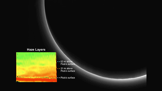
QUOTE (machi @ Jul 24 2015, 08:30 PM)
Haze layers from the LORRI camera.
I wonder if the gaseous component would have been visible to the camera if haze wasn't present.
A comment was made this would be invisible to the human eye. That might be true looking straight up during daylight, though I think maybe right near the sun if it is obscured by a terrain feature on the horizon you could see something. It would thus be interesting to model the appearance of the Plutonian sky, as I've done similarly for Earth and Mars.
I've poked around NH website and NASA TV and can find the images and movies that were part of yesterday's new conference, but can't find the an archive of the new conference itself. Does it exist somewhere i'm missing?
Thanks
Thanks
QUOTE (Floyd @ Jul 26 2015, 01:12 AM)
I've poked around NH website and NASA TV and can find the images and movies that were part of yesterday's new conference, but can't find the an archive of the new conference itself. Does it exist somewhere i'm missing?
They show up on NASA's youtube channel. It's here.
QUOTE (Bill Harris @ Jul 25 2015, 02:13 PM)
I'm starting work on a Poster Session on the Geomorphology of Pluto.
It's a work-in-progress, but here is the initial Index image:
https://univ.smugmug.com/New-Horizons-Missi...ron/i-wQNMfhT/A
--Bill
It's a work-in-progress, but here is the initial Index image:
https://univ.smugmug.com/New-Horizons-Missi...ron/i-wQNMfhT/A
--Bill
Thanks for sharing. If I'm not mistaken, the dunes and ropey terrain are one and the same thing. There are also a couple of major features worth including. In blue I've circled a region of swirls where there is likely to be a second frozen lake. In red is Pluto's version of Valles Marineris.
Click to view attachment
EDIT: I've added a green rectangle covering another possible frozen lake. This one appears to have drainage channels leading from the north and west into a series of interconnecting(?) basins, bounded on the south and east sides by flow fronts from widespread resurfacing events dating from soon after Pluto's formation. Interestingly, the channels on the north side all seem to emerge from holes in the ground!
The jumbled blocks in the upper left corner:
Click to view attachment
appear to be a portion of the 'cellular' terrain outlined in yellow:
Click to view attachment
Perhaps these 'cells' are actually mountains similar to those of Norgay and Hillary Montes.
Click to view attachment
appear to be a portion of the 'cellular' terrain outlined in yellow:
Click to view attachment
Perhaps these 'cells' are actually mountains similar to those of Norgay and Hillary Montes.
QUOTE (John Broughton @ Jul 25 2015, 06:55 PM)
If I'm not mistaken, the dunes and ropey terrain are one and the same thing.
The dunes and ropey terrain are different in sized and texture, IMO. BUT we'll see how they look as we get better imagery. The "dunes", or "dune-oid" features were named that because that was my first impression from the approach imagery, so for lack of any other term, I coined a word. They are more rocky and wind-sculpted and not at all dune-like. But remember, that geomorph map was put together a week ago and we've learned so much in just a few days! I'm working on a newer and sharper geo map based on the recent imagery.
QUOTE
There are also a couple of major features worth including. In blue I've circled a region of swirls where there is likely to be a second frozen lake. In red is Pluto's version of Valles Marineris.
Yes! So much more is visible, and the later images have rotated the topography eastward, so what was barely visible in the west (left limb) is now clearly visible. And the MVIC color info is so much better. And we've barely scratched the surface.
These are indeed wonderfully strange little worlds.
--Bill
Better suited for Pluto System Speculation...
Wonderful collage and outlines the variations beautifully. Glad you included the fourth image from left, top row... yet another curious feature!
Mark
Mark
QUOTE (Gladstoner @ Jul 26 2015, 02:34 AM)
The jumbled blocks in the upper left corner:
appear to be a portion of the 'cellular' terrain outlined in yellow:
Perhaps these 'cells' are actually mountains similar to those of Norgay and Hillary Montes.
appear to be a portion of the 'cellular' terrain outlined in yellow:
Perhaps these 'cells' are actually mountains similar to those of Norgay and Hillary Montes.
I noticed that too, only that I referred to it as chaos terrain (#956) - which seems all the more fitting now due to its persistent jumbled appearance.
Interestingly, the area does not appear old; so it supports the idea that some really violent stuff could have gone on recently. Luckily, the entire area is of course covered by the stereo mosaic.
QUOTE (scalbers @ Jul 22 2015, 11:22 AM)
Here is my map update with the portions of both hi-res mosaics included that are available. The attachment is now 6717 pixels wide. Thanks wildespace for posting the two frame stitched mosaic, and to the NH team for the amazing and cool mission!
Click to view attachment
Full 8K version is here. We may be able to compare this with my previous map to see stereo in the region of Norgay Montes.
Click to view attachment
Full 8K version is here. We may be able to compare this with my previous map to see stereo in the region of Norgay Montes.
That's amazing work! Is it possible you could add coverage to part of the southern area with the Hubble Faint Object Camera map?
QUOTE (Antdoghalo @ Jul 26 2015, 05:57 AM)
That's amazing work! Is it possible you could add coverage to part of the southern area with the Hubble Faint Object Camera map?
You should see the updated 16K he posted later. http://laps.noaa.gov/albers/sos/pluto/pluto_rgb_cyl_16k.png
(might need to save that first; my browser couldn't handle it)
QUOTE (Antdoghalo @ Jul 26 2015, 09:57 AM)
That's amazing work! Is it possible you could add coverage to part of the southern area with the Hubble Faint Object Camera map?
Thanks Antdoghalo. Incidentally I'm still getting better displays of the 16K version (thanks Herobrine for posting your included mosaic) using Firefox compared with another browser. Good idea with the FOC map. I've seen another effort to do this type of combination, and I can try using the FOC map as a background instead of the July 7 NH map.
With Science On A Sphere we're also working on an animation that shows the history of the maps over the decades.
Here's my attempt at Hydra from 4 LORRI images.
Click to view attachment
I don't think it turned out any better than the published version, just a little higher contrast.
Click for GIF
Click to view attachment
Click to view attachment
I don't think it turned out any better than the published version, just a little higher contrast.
Click for GIF
Click to view attachment
QUOTE (Herobrine @ Jul 26 2015, 04:13 PM)
Here's my attempt at Hydra from 4 LORRI images.
Nice work! I did the "official" one. The data we have on the ground now is highly compressed, so I don't think there is any more information that can be pulled out of it until we have the lossless versions.
QUOTE (tedstryk @ Jul 26 2015, 11:41 AM)
Nice work! I did the "official" one. The data we have on the ground now is highly compressed, so I don't think there is any more information that can be pulled out of it until we have the lossless versions.
Great work.
When the lossless comes down, will that be 16 bits/sample or 12 bits/sample stored in 16?
QUOTE (scalbers @ Jul 25 2015, 03:46 PM)
I wonder if the gaseous component would have been visible to the camera if haze wasn't present.
I once did the calculation of how much more air an observer standing on Earth looks through when looking at the Sun at sunrise/sunset versus looking at the zenith, and the answer was about 16x. Therefore, someone in space looking at the sunset would be looking through 32x as much air as the ground-bound observer looking up at the zenith.
For Pluto, however, this ratio will be lower because the scale height is much higher about 60 km for Pluto versus 8 km for Earth.
All of that said, the question is what is visible in the first place 32 times zero is still zero. It seems to me that Pluto's atmosphere when backlit would not be visible to an observer because it is so much thinner than Earth's. But this gets into issues of camera (or eye) sensitivity.
QUOTE (Herobrine @ Jul 26 2015, 04:13 PM)
Here's my attempt at Hydra from 4 LORRI images.
Click to view attachment
I don't think it turned out any better than the published version, just a little higher contrast.
Click for GIF
Click to view attachment
Click to view attachment
I don't think it turned out any better than the published version, just a little higher contrast.
Click for GIF
Click to view attachment
It looks like 67P
MOD NOTE: Moved 13 posts to a new topic about HST albedo map processing.
QUOTE (JRehling @ Jul 26 2015, 07:00 PM)
I once did the calculation of how much more air an observer standing on Earth looks through when looking at the Sun at sunrise/sunset versus looking at the zenith, and the answer was about 16x. Therefore, someone in space looking at the sunset would be looking through 32x as much air as the ground-bound observer looking up at the zenith.
For Pluto, however, this ratio will be lower because the scale height is much higher – about 60 km for Pluto versus 8 km for Earth.
All of that said, the question is what is visible in the first place – 32 times zero is still zero. It seems to me that Pluto's atmosphere when backlit would not be visible to an observer because it is so much thinner than Earth's. But this gets into issues of camera (or eye) sensitivity.
I'll have to work through some numbers on this when I get the time. I think the gaseous component would be brighter (for example) than the Milky Way (in other words > 250 nanolamberts) if we had sunlight present at the Earth's level. However since it is actually at Pluto's level then the brightness would probably go below naked eye visibility. This would be at the zenith.
I agree about the scale height being important. Looking at the limb it might be a close call and deserving of a more careful calculation. One would also have to consider the relationships between pressure, gravity, temperature, and density, on Pluto compared with Earth. The surface gravity on Pluto is .07 that of Earth, though I believe this difference is partly compensated by Pluto's cold temperature when considering the ratio of scale heights. For reference the number of airmasses we look through on the horizon on Earth is closer to 40 with a scale height of 8km (at least in the troposphere). I'm contemplating developing a general equation for how this varies depending on planetary radius and scale height.
Whether or not backlighting is involved is mostly immaterial for the gaseous component assuming Rayleigh scattering is involved. Backlighting is much more important for the haze component.
Global map of Pluto, without grid
with grid
ETA: A couple of extra strips at higher resolution I haven't seen before in these crops.
Click to view attachment
Click to view attachment
I wonder if they are partial downloads of other frames of the 15 image mosaic or pieces of the higher resolution passes from near close approach.
with grid
ETA: A couple of extra strips at higher resolution I haven't seen before in these crops.
Click to view attachment
Click to view attachment
I wonder if they are partial downloads of other frames of the 15 image mosaic or pieces of the higher resolution passes from near close approach.
QUOTE
I'll have to work through some numbers on this when I get the time. I think...
My thoughts-- and I'm not an atmosphere guy, so this is arm-waving for the FWIW folder-- is that the visibility is due to aerosols. Remember, you've got a reactive atmosphere with solar UV.
It'd be interesting to orient the "sunset" image with north up and see if there is a difference between the "dawn" haze and the "twilight" haze, ie, that which is coming up from night/cold and that which is going from sunlight/cool. With the wacky axial tilt, there may not even be a defined sunrise/sunset now-- what latitude is the "arctic circle" at?
--Bill
Indeed most of the light we are seeing is aerosols as the team stated. I'm simply wondering what the gas alone (and combined with the aerosols) would have looked like, both to the camera and to a human observer at various times of day and vantage points. The solar declination is now at about 51.5 degrees, so anywhere north of 38.5N has a midnight sun.
QUOTE (alan @ Jul 27 2015, 05:38 PM)
ETA: A couple of extra strips at higher resolution I haven't seen before in these crops.
[...]
I wonder if they are partial downloads of other frames of the 15 image mosaic or pieces of the higher resolution passes from near close approach.
[...]
I wonder if they are partial downloads of other frames of the 15 image mosaic or pieces of the higher resolution passes from near close approach.
If there weren't two different strips, I'd assume they were from the highest resolution imaging pass. I haven't heard of that covering two separate bands though, so I have no idea what those are from, but I want them.

I'd also like to know where the full-disk "farewell" image comes from; there are three similar images in SOC that only cover a little more than 1/4 of the disk but nothing in there for the rest of the disk. Also, Nix.
QUOTE (alan @ Jul 27 2015, 03:38 PM)
I wonder if they are partial downloads of other frames of the 15 image mosaic or pieces of the higher resolution passes from near close approach.
FWIW, compared to the image tiles released last week, the resolution of the strips seems to be comparable, and the length of both is similar to the widths of the tiles, more or less.
I'm just happy that we can (potentially) expect more images before September.
I did some careful combining of the 3 backlit images in SOC. I haven't done anything with it yet (was thinking about writing something to "unwrap" and combine the atmosphere to get a better sense of the gradient), but here it is, along with some extra information.
In this, the light from all 3 images has been added together. The top and right edges show artifacts from the borders of the other two images.
Click to view attachment
In this, the light from all 3 images has been averaged.
Click to view attachment
The base image for these is lor_0299206716
lor_0299206715 offset (px): 3.875, 4.25
lor_0299206714 offset (px): 7.75, 8.5
Pluto center (px): 795.75, 32.5 (Note: 0,0 means the exact top-left corner of the image; 0.5,0.5 is the middle of the top-left pixel)
Pluto radius (px): 662.25
You can throw whatever +/- you want on those numbers; I feel pretty good about them being within a pixel, though.
lor_0299206714 was taken (only) two seconds before lor_0299206716, and one second before lor_0299206715. There's a 0.0076% difference in scale between the 1st and 3rd images because of the slight difference in distance between the two images, which amounts to a little less than 1/10th (0.078) of a pixel over the width of the image. Consequently, the apparent diameter of Pluto in lor_0299206714 should only be about 0.1 pixels wider than in lor_0299206716. I didn't account for this slight difference.
QUOTE (alan @ Jul 27 2015, 04:38 PM)
I wonder if they are partial downloads of other frames of the 15 image mosaic or pieces of the higher resolution passes from near close approach.
Remind me of the GALILEO image noodles. Hints of more to come.
Craig
This is an improved version of a CGI rendering I posted in another thread utilizing the new map and Bjorn's map of Charon with the high resolution frames added. Colorization is false, bump mapping cloned, and global orientations altered to make a prettier picture, but it does give an idea of what's going to be possible as the extant imagery continues to expand and improve.
 Pluto and Charon by Orion Moon, on Flickr
Also, a perspective view of the high-resolution images.
 Pluto Perspective Rendering by Orion Moon, on Flickr
Pluto and Charon by Orion Moon, on FlickrAlso, a perspective view of the high-resolution images.
Pluto Perspective Rendering by Orion Moon, on Flickr
That's beautiful, Exploit!
So, I took a first stab at writing a program to unwrap the atmosphere from Pluto, from the 3 LORRI images, and here's the first thing it spit out.
Click to view attachment
That's the atmosphere/haze unwrapped radially from due left to due down (90-degree arc) in the LORRI images. The bottom pixel row is the surface of Pluto, as defined in my post a few posts back. The top row is 127 pixels out from the surface, or about 227 kilometers.
It dawned on me, after generating this, that this must be essentially the same thing that haze graphic was showing at the last press conference.
In fact, looking at the two, I see all of the same shapes; mine just goes about twice as high.
If I knew how to apply a LUT in GIMP, I'd color it the same and compare them. I guess I could write a LUT into my program, but that sounds suspiciously similar to work.
I'll probably play with the code for a while and edit this post to update it if I come up with anything new or interesting.
Edit: Here's a wider range of angles (100 degrees instead of 90) and half the height (about 114 km or 71 miles) done at a higher sampling for better results.
Click to view attachment and with exaggerated detail contrast Click to view attachment
And finally, I got around to applying a LUT of some sort, though I don't have the same kind used in that graphic.
Click to view attachment
That's a blink between the graphic used in the press conference and my own, made from the LORRI images with the little program I wrote.
Mine covers more to the right and less to the left, compared to the presentation graphic, so it's offset.
Note: I just roughly eyeballed the vertical scaling and alignment of the two for that GIF.
QUOTE (scalbers @ Jul 27 2015, 03:20 PM)
The solar declination is now at about 51.5 degrees, so anywhere north of 38.5N has a midnight sun.
And that's at the surface. The atmosphere one or two scale heights up would be in "permanent" sunlight even farther south.
Part of the northmost higher-resolution limb really looks like Venus' surface close up. 
The surface there looks relatively young, with few well-preserved craters, but then again, it's also not far from the supposed polar cap.
Here's the Venus-looking bit:
Click to view attachment
Really strange-looking terrain.
I was wondering why they did not download thumbnails of their observations; maybe they did download some.
Heavily eroded crater?
Click to view attachment
The full-ring images are opnavs, taken much later. http://www.planetary.org/blogs/emily-lakda...k-at-pluto.html
The surface there looks relatively young, with few well-preserved craters, but then again, it's also not far from the supposed polar cap.
Here's the Venus-looking bit:
Click to view attachment
Really strange-looking terrain.
I was wondering why they did not download thumbnails of their observations; maybe they did download some.
Heavily eroded crater?
Click to view attachment
QUOTE (Herobrine @ Jul 28 2015, 12:45 AM)
I'd also like to know where the full-disk "farewell" image comes from; there are three similar images in SOC that only cover a little more than 1/4 of the disk but nothing in there for the rest of the disk. Also, Nix.
The full-ring images are opnavs, taken much later. http://www.planetary.org/blogs/emily-lakda...k-at-pluto.html
QUOTE
The atmosphere one or two scale heights up would be in "permanent" sunlight
And, IIRC, the scale height of the atmosphere is/was given as ~60km, pre-NH. I've not seen the current buzz on that value.
One interesting paper I came across the other day:
Thermal tides on Pluto - LESIA - Observatoire de Paris in PDF format:
http://www.lesia.obspm.fr/perso/bruno-sica..._waves_Ic10.pdf
Although Pluto has a thin and cold atmosphere, it is proving to be hardly boring.
--Bill
This is a "lo-fi" version of our main content. To view the full version with more information, formatting and images, please click here.