Help - Search - Members - Calendar
Full Version: New Horizons: Near Encounter Phase
Unmanned Spaceflight.com > Outer Solar System > Pluto / KBO > New Horizons
Pages: 1, 2, 3, 4, 5, 6, 7, 8, 9, 10, 11, 12, 13, 14, 15, 16, 17, 18, 19, 20, 21, 22, 23, 24, 25, 26
Nafnlaus
QUOTE (Bill Harris @ Jul 22 2015, 01:28 PM) *
One puzzlement for me is that Pluto has a surface gravity and temperature of perhaps 1/2 that of Titan, so why does it have a so much lower atmospheric pressure (0.0065 kPa vs 147 kPa) than Titan? Is the rate of N2 replenishment from the interior less? Is the Dark Pole that efficient a cold trap? Or does Titan have an anomalously thick atmosphere for other reasons?


Estimated rates of methane and nitrogen escape on Titan are 0.3–5e28  AMU/s - that's 5 to 83 kilograms per second, compared to Pluto's 140. The difference doesn't seem all that unusual.
Nafnlaus
QUOTE (Xcalibrator @ Jul 22 2015, 03:24 PM) *
Being a bit pedantic here but the "half a ton per second" that keeps being mentioned isn't quite right. The original statement by Fran Bagenal was 500 tons per hour, which works out to 0.14 tons/sec or 3e27 N2 molecules/sec, in excellent agreement with recent models (Tucker et al. 2015, Icarus 246, 291; Zhu et al. 2014, Icarus 228, 301). FWIW this also happens to be roughly the same outgassing rate as for comets near 1 AU, although in that case it's mostly H2O, CO2, and CO.


Thanks for the correction, Xcalibrator - I'll correct my earlier posts. By all means, be pedantic, accuracy is important! smile.gif
alan
QUOTE (alk3997 @ Jul 22 2015, 10:17 AM) *
The problem a few weeks ago was that the dark material appeared to have no craters. Now in the newest released image, there are craters in the dark terrain. And, many craters in some areas.

So, maybe the idea has some merit after all. If this is correct, where you see dark material, you are seeing under the ice to the older terrain. This also means that the whale is a temporary structure. It could be a bear by Pluto's next orbit.

The parts of Cthulhu visible in the recent release have many crater, but remember that the dark area in the lower right of the three image mosaic did not.

On another note this paper modeling the movement of nitrogen in Pluto's atmosphere and its surface Pluto’s climate modeled with new observational constraints used a Nitrogen inventory of 50-200 kg/m^2. Evenly spread that would be ~0.05 - 0.2 m, or if concentrated into a polar cap or in Tombaugh Regio perhaps a few meters.
scalbers
Here is my map update with the portions of both hi-res mosaics included that are available. The attachment is now 6717 pixels wide. Thanks wildespace for posting the two frame stitched mosaic, and to the NH team for the amazing and cool mission!

Click to view attachment

Full 8K version is here. We may be able to compare this with my previous map to see stereo in the region of Norgay Montes.
alk3997
QUOTE (alan @ Jul 22 2015, 11:14 AM) *
The parts of Cthulhu visible in the recent release have many crater, but remember that the dark area in the lower right of the three image mosaic did not.


That's a good point. Perhaps there is some resurfacing going on when the ice covers some of the dark areas? Need more data...
tedstryk
QUOTE (nogal @ Jul 21 2015, 09:50 PM) *
Here is a link with information on Ted Stryk http://www.planetary.org/connect/our-exper.../ted-stryk.html

Fernando


Alternatively, I'm here. laugh.gif
FOV
QUOTE (Phil Stooke @ Jul 21 2015, 03:39 PM) *
"The Pluto montes are maybe 100 million years old, according to NH scientists."

No, the smooth plains could be that young. There are not really any constraints on the age of the mountains. We don't have the resolution (yet) to judge the degree of cratering in the rougher areas, and anyway, if you look at the lunar mountains in high resolution images, their slopes are mostly uncratered as well because of mass wasting (landslides, regolith creep etc). In other words, a 4 billion year old mountain has very few small craters on it, but it's only the regolith blanket that's young, not the mountain. That may be true here on Pluto as well.

Phil


Okay when I said Pluto montes I meant Pluto mountains and this is today's PPOD:

http://www.boulder.swri.edu/ppod/

Just don't want to confuse myself, or others.
Sherbert
Great to see all the ideas about the terrain in the new image. So here are some more to add to the melting pot. So as not to take up too much space my thoughts are included in the image description.

https://www.flickr.com/photos/124013840@N06...eposted-public/

Alan, matiac and Nafnlaus all had some really good insights I think. The visual similarity to seas, glacier type terrain and Pongo type terrain here is quite evident. The ice mountains are still a bit of a puzzle, I'm not wholly convinced by any theory yet, even mine.

MarsinMyLifetime's comment about analogues and homologues I thought was quite astute too. Trying to visualise this strange icy environment is going to be difficult without using Earth, Mars, Titan, Triton etc. analogues unless we want to start adding new words to the lexicon of planetary geology.
Exploitcorporations
A lengthy piece by Mika McKinnon was published today on io9 regarding the collision origin theory for Charon and the possibility of a related subsurface ocean on Pluto.

http://space.io9.com/could-a-massive-colli...n-on-1719439790
Habukaz
QUOTE (alan @ Jul 22 2015, 06:14 PM) *
The parts of Cthulhu visible in the recent release have many crater, but remember that the dark area in the lower right of the three image mosaic did not.


Indeed does it appear so. I believe that altitude (and perhaps latitude) is the common factor for the dark terrain.
TSC
This section of episode 4 of BBC's "Frozen Planet" (minute 16 - video starts there after some ads) describes the freezing of an ocean. The similarities with the cells in Tombaugh Regio is striking (and even with the mountains that seem to appear at the cell boundaries)... The scale is completely different of course, but suddenly Pluto seemed a bit less alien...

BBC's Frozen Planet, Episode 4 (Autumn)

(resemblances with Pluto's small black spots also appear at minute 43:50 wink.gif )
Daniele_bianchino_Italy
QUOTE (TSC @ Jul 22 2015, 07:07 PM) *
This section of episode 4 of BBC's "Frozen Planet" (minute 16 - video starts there after some ads) describes the freezing of an ocean. The similarities with the cells in Tombaugh Regio is striking (and even with the mountains that seem to appear at the cell boundaries)... The scale is completely different of course, but suddenly Pluto seemed a bit less alien...

BBC's Frozen Planet, Episode 4 (Autumn)

(resemblances with Pluto's small black spots also appear at minute 43:50 wink.gif )


MarsInMyLifetime
Not all "plutobergs" are at the 11,000 foot high scale. The smaller ones we see are certainly in the range of the frozen-in island and tabular iceberg imaged in this blog (linked to their sources). Berg may in fact be the most accurate name for these mountains, given the meaning of the term we've come to associate with our terrestrial ice mountains. What I see as similar in these images is breakup (as in our own unfortunate Larsen ice sheet in Antarctica) as the formative mechanism, and the "close to shore" nature of their placement. Furthermore, a sea of either hidden liquid or "meltwater" is needed to embay the pieces for refreezing into place. The clear non-sequitur to me is the angled, almost glinty nature of the sides of Pluto's bergs... at these temperatures, perhaps massive crystalline features are possible, and the mechanics of very hard frozen ice may have shaped them as well.

http://antarcticjournal.blogspot.com/2006_11_01_archive.html

Dan Delany
For what it's worth, re: my "transparent ice" post a few pages back - I was pretty skeptical that this was even a possibility. And I'm certainly still not convinced, we'll need better data to be sure. But I did do a bit of research and found some discussion of this possibility in Alan Stern's "Pluto and Charon" book, in the chapter by Cruinkshank et al., so it seems plausible at least:

QUOTE
...there is every expectation that at least a portion of the N2 inventory is evaporated from some regions of the surface and deposited elsewhere during the seasonal cycle. Freshly deposited N2 probably occurs in fine crystals, which are then sintered to form a highly transparent polycrystalline structure with very few scattering centers. Because N2 gas dominates the atmosphere, the solid frost tends to condense without bubbles of impurity gases; the CH4 detected in the atmosphere and in the ice, and the CO detected in the ice, are both soluble in N2 in a solid solution, and are presumed to co-condense with the N2, at least in part...

Eluszkiewicz (1991) and Brown et al. (1995) have described the sintering process in which individual grains or polycrystals fuse into a large-scale transparent volume. As adjacent contacting grains strive to minimize surface energy, in a way similar to fusing water drops, the contact points slowly enlarge, moving the grain centers closer to one another, eventually resulting in larger grains, lesser interstitial volume, and increased bulk density.


More here on Google Books. I would (naively) expect, though, for this process to occur in large, thin sheets of N2 ice, rather than the perceived thick "ice dome" that seems to surround the mountain in my earlier post.
Herobrine
IANASNAIAPP, but..
Since the topic of "hot pixels" came up recently (with an apparent "glint" on Tombaugh Regio), I wanted to mention that you can check images against LORRI calibration data hosted on University of Maryland's site. If you compare a LORRI image against the current flat field data, you can identify many false features. If you aren't set up for FITS, here's a linear 8-bit PNG derived from that file:
Click to view attachment
The original data is 64-bit floating-point.

For an example, here's a blink between that "glint" and the current flat field data.
Click to animate
Click to view attachment
In this case, you can very easily tell that it, as well as a second, more subtle bright spot nearby are present in the flat field data, and are therefore not real features.
You can also compare to another LORRI image, but that will be less reliable, because not all flat field artefacts will be visible in all LORRI images (particularly these JPEGs), and because it's possible that the other image will actually have a real feature at that location, whereas there are no "real features" in the flat field data.

I should offer the disclaimer that I just googled to see if that data were available anywhere and went with the first place I found it. It's possible there exist a better/more complete/more recent set of data elsewhere. Come to think of it, I'd be surprised if LORRI calibration data hasn't been linked on this forum before.

I've actually started using a modified version of that PNG file as an alpha channel, with a blurred version of the LORRI image underneath, to more-or-less replace trouble spots with lower-resolution data, with good results.
neo56
My take on the LORRI mosaic and its colorization as a LRGB with the 2x2 color picture. It was not easy to match the two pictures!


wildespace
The "new mountain range" image (stitched to the other "mountains" image) is one of the most interesting and awe-inspiring images I've seen beyond our planet Earth. The way the dark terrain suddenly gives way to the high-albedo banded plains and "glossy" mountains is fantastic.

~~~

As an aside (and entering speculative territory), try looking at the two-frame mosaic (and other images) with just one eye. I've read somewhere that looking at an image with just one eye can evoke the sense of depth, and in my case it certainly works. Just keep looking at the images with just one eye, you might be surprised.
Gladstoner
QUOTE (wildespace @ Jul 22 2015, 03:06 PM) *
The "new mountain range" image (stitched to the other "mountains" image) is one of the most interesting and awe-inspiring images I've seen beyond our planet Earth. The way the dark terrain suddenly gives way to the high-albedo banded plains and "glossy" mountains is fantastic.


I think the technical term is 'gobsmacked'. smile.gif
scalbers
Here is a full 16K version of the map I posted earlier today. It just barely displays in my default browser though FireFox on a Mac is working well.

http://laps.noaa.gov/albers/sos/pluto/pluto_rgb_cyl_16k.png
Sherbert
QUOTE (neo56 @ Jul 22 2015, 09:58 PM) *
My take on the LORRI mosaic and its colorization as a LRGB with the 2x2 color picture. It was not easy to match the two pictures!

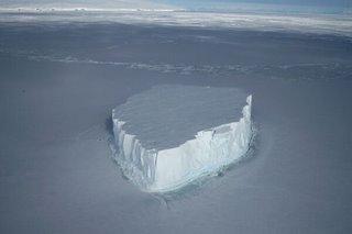
Thomas, those images are glorious. How many comparable size areas of Earth have all this crazy terrain?

Thanks Herobrine too. Those hot pixels have already embarrassed me, very helpful.

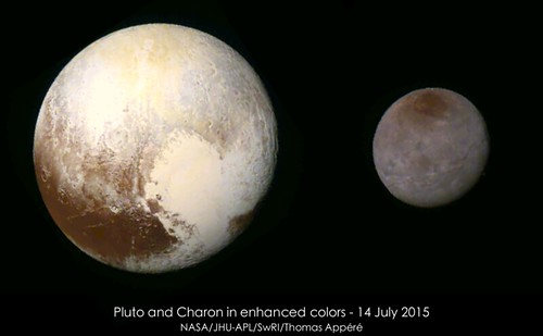
MarsinMyLifetime, there may be a solution to your problem. The Water ice mountain ranges are located close to the equator and therefore receive sunshine all year round. The beyond 90 degree axil tilt means that the Sun is always in a roughly 120 arc in their Northern sky. The mountain faces facing in this direction are all shiny and crystalline looking, partly because the Sun is clearly shining on that side, and surely this permanent insolation is going to have an impact on the physical appearance. Scalbers suggests a fine sublimation lag of micron sized dust, organics trapped within the ice when it formed and crystals of volatile ices frost. Combined with this is small scale rubble, possibly from small scale thermal stress mass wastage. This mixture creates a sufficiently mobile surface for this face of the mountain to reach the angle of repose. That relatively thin layer, is constantly being refreshed, in comparison to the rest of the surface more thickly covered in organics.

The other faces receive very little sunlight throughout the Plutonian year in comparison, there, faces will experience greater extremes of thermal stress and more, larger, recognisable, sublimation features. With far less disturbance of the surface these areas accumulate a thicker coating of organics and dust, making them darker in appearance, the contrast no doubt, fooling the brain into perceiving the lighter side as slightly brighter too. These faces I would expect to have an appearance similar to the densely consolidated material on 67P, another large chunk of Water ice in a near vacuum.

My initial impression that these ice mountains look very alien to the terrain by their appearance, is replaced by, the Water ice looking alien on a Nitrogen, Methane and Carbon Monoxide ice dominated world. Everywhere else is rounded and smoothed off, indicative of the softer super volatile ices and their fluid flow possibilities.
serpens
QUOTE (Bill Harris @ Jul 22 2015, 01:28 PM) *
Not bad. Although your comments are directed toward a Plutonian atmosphere, the driving force behind this is Pluto's hydrologic system (and perhaps cycle) based on Nitrogen (et al) under cryogenic conditions.


In 2000 the ESA measured variations in Pluto's surface temperature with readings of 55-65 degrees Kelvin in the warmest areas. These are tantalizingly close to the melting point of Carbon monoxide so a "warm" carbon monoxide lake forming near perihelion as a part of a Pluto hydrologic system, rather than a CO cold trap, would not be outside the bounds of possibility.
ZLD
Oh boy was this mosaic painful.


MarsInMyLifetime
Sherbert, I appreciate your analysis. To validate your premise, I wish we could see talus slopes of that small-scale rubble spreading away from the base of these straight slopes, but at the present resolution, the contact with the plains is quite clean and unlittered looking. This geology is just remarkably unique.

In terms of Earth analogies that might not be very useful after all, I would appreciate some clarification on what things ought to float and what ought to sink in "meltwater" sea of a hypothetical impact event at Tombaugh Regio. Earth's icebergs float because they are less dense than liquid water. Would ice chunks on Pluto sink or float in the melted contents of an impact at Tombaugh Regio? With a relative table of densities of known components on Pluto we might determine whether these ice mountains had floated and froze in their mare of N and CO, or if they would have sunk outright in an impact melt zone, meaning that their origin could not have been due being calved from icy bedrock.
lars_J
QUOTE (ZLD @ Jul 22 2015, 11:56 PM) *
Oh boy was this mosaic painful.


Very nice - but I think there is a misalignment with your color information. Note the mountains in the lower right - the reddish area seems to match the outline of the mountain range but is offset to the left. If you shift the low-res color map over to the right, I think you will get a more accurate color image.
JRehling
There is a phase of solid carbon monoxide that stores a tremendous amount of energy and which can decompress explosively. While the pressures needed to attain this seem to be beyond the ability of Pluto's structure to create, except perhaps at extreme depth, I wonder if Tombaugh Regio might not be the one-time escape of a single explosion of CO from Pluto's mantle or core, going off like a fire extinguisher and blasting laterally (as well as into space).

On the other hand, it would be improbable for a one-time event to have happened so recently as the lack of craters implies, so perhaps its something somewhat less extreme but periodic that vents from Tombaugh Regio. Still, while a single event happening recently is improbable, it's not impossible. It would be nice to know the cratering rate in Pluto's neighborhood, to say the least.
Exploitcorporations
Beautiful work, scalbers, neo56, and ZLD!

Something jumped out at me today while looking at the blocky mountains just east of Cthulhu (no, it wasn't a shoggoth). The 1980 landslide (with subsequent catastrophic eruption) at Mt. St. Helens filled the Toutle River valley to a depth of up to 180 meters, and in several broad areas left spectacular hummocky deposits comprised of rubble from the collapsed cone. The scales are vastly different, but the superficial appearances of these features are strikingly similar to my eyes.

Click to view attachment
Bill Harris
QUOTE (JRehling)
There is a phase of solid carbon monoxide that stores a tremendous amount of energy and which can decompress explosively...


Yes, rather like Coesite with an attitude--

Polycarbonyl
https://en.wikipedia.org/wiki/Polycarbonyl

--Bill
Bill Harris
QUOTE (Exploitcorp)
Something jumped out at me today while looking at the blocky mountains just east of Cthulu (no, it wasn't a shoggoth).

Indeed, those displaced blocks are distinctive.

As an aside, I finally got around to looking up Cthulhu ( Khlûl′-hloo or kə-THOO-loo ):

https://en.wikipedia.org/wiki/Cthulhu

How strange.

--Bill
Exploitcorporations
I've been misspelling it all week. smile.gif It certainly is strange...I think they got it backwards with the naming scheme. The tentacles are on the plains.
John Broughton
The alignment of that impressive chain of eroded mountains at Norgay Montes is consistent with it being part of the rim of an ancient elongated basin enclosing Sputnik Planum (or is it Lacus) I proposed on July 14 as being caused by the grazing impact of a large body (such as Charon's precursor). Here's an updated version of the image I posted, with ellipse extended to fit Norgay Montes more accurately.
Click to view attachment
Nafnlaus
Concerning similarities to Earth that occur at smaller scale here: Do remember that Pluto's gravity is a tiny fraction that of Earth's, which can change the scale of various processes. Also we're dealing with different materials, very different temperature regimes, and much longer temperature cycling timeperiods with a much greater relative difference in absolute temperature.

Concerning the mountains: I know that they look like big icebergs, flat bedrock with smooth solid sides, but these things are tremendously large; it's exceedingly unlikely that there's single crystal planes of that size. Given that they all seem to have slopes at the angle, this says to me that it's their angle of repose, and that this is loose debris (water ice talus, water ice sand, or whatnot) making up their sides. And one would expect - as appears to be the case - that this would be the freshest, shiniest material, since talus "runs" when disturbed, whether by seismicity, thermal expansion/cooling, or a whole host of other factors. Hence even in the old, dark terrain, the "angle of repose slopes" at the edges of craters still appear rather shiny.
Nafnlaus
More to the point concerning talus slopes, one can see in the pictures what appears to be landslides:

http://pluto.jhuapl.edu/soc/Pluto-Encounte...0x632_sci_3.jpg

Check out, for example, the furthest left mountain that has a bright northwestern slope - look at the dark streaks forming perfect lines down it and then stretching a little bit out onto the outlying terrain. I can think of several other possibilities that could form such patterns, such as erosion from flowing liquids (shouldn't exist on the surface), fumaroles deposits (no flowing liquids, and airborne deposits should spread out away from the source), variations in the color of bedrock being eroded (again, should spread out), etc... nothing really seems to match as well as talus landslides.

Examples of landslides on talus slopes:

http://www.feykir.is/kualubbi/wp-content/u...ellshyrna-4.jpg
http://blogs.agu.org/landslideblog/files/2...6-Iceland-1.jpg

Note however that the mountains on Pluto are far higher (but in lower gravity) than these.
Bill Harris
Good post. I am looking at a variety of geomorphic processes creating this landscape. Given the environment, I envision predominantly igneous processes (a fluid which solidifies) and aeolian (seasonal gas transfer from cold pole warming to the warm pole cooling), as opposed to sedimentary (fluid or liquid transport of weathered clastic particles followed by induration).

But depending on what alter imagery shows, I'm open to any processes...

--Bill
Charles
QUOTE (Exploitcorporations @ Jul 23 2015, 04:51 AM) *
Something jumped out at me today while looking at the blocky mountains...


As I noted earlier, the first thing that jumped out at me from the new image is that there is a pit near the peak of many of these mountains. Are these volcanic craters?
MarsInMyLifetime
QUOTE (John Broughton @ Jul 23 2015, 04:10 AM) *
The alignment of that impressive chain of eroded mountains at Norgay Montes is consistent with it being part of the rim of an ancient elongated basin enclosing Sputnik Planum (or is it Lacus) I proposed on July 14 as being caused by the grazing impact of a large body (such as Charon's precursor). Here's an updated version of the image I posted, with ellipse extended to fit Norgay Montes more accurately.

I had the impression of concentric ridges (like the Moon's Orientale Basin), as overlaid in color in this interpretation of that scene:
Click to view attachment
The fit is still approximate in either interpretation since the ridges do not extend all the way around. But this is at least how I see the organization of features.
John Broughton
Bear in mind there's a major rift valley on the left going all the way to the north pole that could contribute to the impression of a double-ring system on that side.

Coming to Sputnik Planum, it could be a frozen lake that melts whenever tidal lock has been disrupted by a large enough impact somewhere in the Pluto-Charon system. If I'm not mistaken, it only takes something like a 30C increase to melt N2 and CO near the surface. During these rare periods, a denser atmosphere would develop. The rise and fall of tides erode the mountains, especially so when there is any ice floating on the surface to act as an abrasive. There's a temperature range between 63 and 68K where liquid nitrogen can have CO ice floating on top. Presumably, methane has been depleted in this area, or it would be a factor too.
Habukaz
The best MVIC images returned of Pluto and Charon thus far, shown in false colours, are out at the Photojournal: http://photojournal.jpl.nasa.gov/catalog/PIA19856
fredk
Finally a good resolution, uncolourized view!

I've improved the alignment of the channels (shifted green by 1 pix) to reduce the colour fringing:
Click to view attachment
Everything was done losslessly from the PIA tif.
4throck
Real color (no IR data) and gamma change to a more natural value:

Click to view attachment
fredk
What did you do for the green channel, 4throck?

Here's Charon after realignment to reduce colour fringing:
Click to view attachment
ugordan
This is what I get after registering the channels a bit better, subtracting a greenish background signal and running it through a CIE XYZ linear spectral interpolation between the filter wavelengths. The NIR frame is effectively discarded in the process and since the blue frame is very jpeggy, the end result is more blocky. I assumed that since this is a browse jpeg (?) product downlinked from the spacecraft that it was 12->8 bit encoded with a square root function (which mimics 2.2 gamma fairly well) so no additional gamma correction was done.

Click to view attachment
squirreltape
QUOTE (Charles @ Jul 23 2015, 03:47 PM) *
As I noted earlier, the first thing that jumped out at me from the new image is that there is a pit near the peak of many of these mountains. Are these volcanic craters?


I noticed these too Charles and while there does seem to be 'structure' associated with many of the peaks I hesitate to call them cryovents for several reasons. Cheifly, the mountain peaks seem to me to be covered in the darker material above a common line and are reminiscent of the dark terrain (they may even be the remains of the darker terrain after erosion processes); this makes the peaks appear to be a confusion of albedo variations giving the impression of indentations (although a subset do seem to display large, clear craters/slumps/calderas/vents so maybe these are candidates). Also, we can look to our Moon for a possible analogy... for centuries lunar peaks have been noted to come with craters and as it was incorrectly assumed the odds of an impact right at the top of a mountain would be miniscule so volcanic calderas they must be and the volcanic origin of the lunar craters moved to surer footing. But, as we know, the tide changed during the 50's and 60's and when Apollo showed us the impact hypothesis was actually correct volcanoes took the back seat as an explanation. While lunar vulcanism is terribly important, it manifests in different ways. Pluto is so different I'm sure the mechanism is 'vaguely similar' at best there but, do we see any evidence of lobate flows or rilles showing fluid transport away from the vents. If the vents are still emplaced then the terrain should also preserve evidence of where the stuff that emerged went (I'm imagining cryo-volcanic vents rather than 'cryo-clastic vents')

I suspect that mass wasting, sublimation effects, impacts on the slopes, and organic coatings are probably responsible for any pits but the possibilty of vents should most certainly be entertained as a possibility. The best of it is, with the upcoming higher res views it should make life easier to determine between vent, impact or 'other'... exciting times.
Sherbert
QUOTE
In terms of Earth analogies that might not be very useful after all, I would appreciate some clarification on what things ought to float and what ought to sink in "meltwater" sea of a hypothetical impact event at Tombaugh Regio. Earth's icebergs float because they are less dense than liquid water. Would ice chunks on Pluto sink or float in the melted contents of an impact at Tombaugh Regio? With a relative table of densities of known components on Pluto we might determine whether these ice mountains had floated and froze in their mare of N and CO, or if they would have sunk outright in an impact melt zone, meaning that their origin could not have been due being calved from icy bedrock.

I remember somebody posting some densities for super volatile ices a while back, but looking back through the posts I could not find it. I remember them saying they were hard to find. I spent a couple of hours yesterday trying to find them with no luck. These figures are from memory so may not be accurate. Carbon Monoxide ice 0.56 g/cm^3, Nitrogen ice 0.91g/cm^3 and Methane 0.96 g/cm^3 ( not sure about the last one). Water ice has a range of densities depending on type of ice and varies between about 0.76 and 0.98 g/cm^3.

Carbon Monoxide is the interesting one. Comet 67P has a density of about 0.47 g/cm^3. This results in an estimate by the Rosetta science team of a porosity of about 60-70%, which for me seems not totally plausible in light of the images we have seen. The assumption is that the comet is made largely of Water ice and Carbon Dioxide ice, which has a density of about 1.4 to 1.60 g/cm^3. Carbon Monoxide is seen in significant quantities escaping the surface, perhaps there is a lot more buried Carbon Monoxide in comets than projected . So comets are reservoirs of Carbon Monoxide as well as Water ice and Carbon Dioxide. Carbon Dioxide seems rarely mentioned in connection with Pluto, previous measurements from Earth have detected Nitrogen and Methane. Water and Carbon Dioxide are everywhere, as is Carbon Monoxide, the fifth most abundant molecule in space.

The Tombaugh impact object I have conjectured as possibly being Charon, a de-orbiting satellite, or a large mountain sized piece of space debris, arranged in order of increasing plausibility. Exploitcorporations posted an article about Charon's capture by Pluto, Post1059. Maybe not quite so improbable as I thought. However a Comet hitting Pluto seems almost inevitable. In fact its probable that several comets have hit Pluto during its lifetime. Is a Comet the smoking gun. JB and I have been pretty sure about a tangential impact creating the Tombaugh region for some time. It was a strong impression, with little data to point at and say "look there it is". With the four closer images, there is more evidence, but its still open to interpretation. To me a Comet impact at Tombaugh makes an awful lot of sense.
Bill Harris
QUOTE (Exploitcorporations @ Jul 23 2015, 04:49 AM) *
I've been misspelling it all week. smile.gif It certainly is strange...I think they got it backwards with the naming scheme.

You're steps ahead of me. As much as I may sound like a backwoods yokel, I had no clue what "Cthulhu" was from. I've read Lovecraft, but had never gotten into that series. Only got around to looking it up the other day. And I do need, just to be well-rounded, to look up the other feature names (namely Krun, Ala, Balrog, Vacub-Came, Hun-Came, and Meng-p'o seen on a vid screen grab). There may well be a whole pantheon of oddity there...

Here is a list of the proposed IAU names for the Pluto system, from the site OurPluto.org

http://www.ourpluto.org/pluto


--Bill
JRehling
At the moment, I'd say my pet theory about Tombaugh Regio is that as Pluto formed, it buried some ices that compressed under the weight of the mantle above them. An impact where Tombaugh now is may have popped the soda can open, so to speak, and allowed a catastrophic release of pressure, blasting CO ice upwards and outwards, covering the inward facing slopes of distant craters as well as the entire central region. This may be the largest one-time eruption we've ever seen the results of.
lars_J
QUOTE (John Broughton @ Jul 23 2015, 05:10 AM) *
The alignment of that impressive chain of eroded mountains at Norgay Montes is consistent with it being part of the rim of an ancient elongated basin enclosing Sputnik Planum (or is it Lacus) I proposed on July 14 as being caused by the grazing impact of a large body (such as Charon's precursor). Here's an updated version of the image I posted, with ellipse extended to fit Norgay Montes more accurately.
Click to view attachment


Very doubtful, IMO. A grazing impact by a Charon sized body would likely resurface the ENTIRE surface of Pluto, and would not leave just a clear basin footprint.
Sherbert
QUOTE (Nafnlaus @ Jul 23 2015, 02:16 PM) *
More to the point concerning talus slopes, one can see in the pictures what appears to be landslides:

http://pluto.jhuapl.edu/soc/Pluto-Encounte...0x632_sci_3.jpg

You beat me to it. I've found this image of a Talus deposit at Isfjord on Svalbard.

https://en.wikipedia.org/wiki/Scree#/media/...esIsfjorden.jpg

Here is closer view of the Norgay mountain you mention.

https://www.flickr.com/photos/124013840@N06...eposted-public/

Perhaps some of the "moats" are not depressions creating shadows, but darker Talus material.
neo56
My take on MVIC/Ralph picture as a montage of Pluto and Charon. I just shifted the green channel by 1 pixel as fredk did.

ZLD
QUOTE (lars_J @ Jul 22 2015, 11:32 PM) *
Very nice - but I think there is a misalignment with your color information. Note the mountains in the lower right - the reddish area seems to match the outline of the mountain range but is offset to the left. If you shift the low-res color map over to the right, I think you will get a more accurate color image.


Quite right Ian. The color data isn't the best from the initial warp I did of the MVIC image.

I took the original MVIC image and quite meticulously rewarped it to fit this mosaic for the image below.


This is missing the red channel from the E-Health 1 image release. I believe in the MVIC release was using the infrared (mapped to dark red), blue (mapped to turquoise) and methane (mapped to yellow green) filters.

I'll see about getting the red channel information back in there and doing a better approximate true color composite.

Edit: Haha, while I was working on this, I missed that new MVIC data had come down. Oh well. Happy to see I wasn't too terribly far off in my best guess approximation earlier, if even just a tad too exaggerated still.
MarsInMyLifetime
QUOTE (Sherbert @ Jul 23 2015, 01:03 PM) *
To me a Comet impact at Tombaugh makes an awful lot of sense.

And to me as well. The "tongue" feature does not need to be a gouge. In fact, when I invert those images so that that terminator region is on top, I perceive the tongue as being a slightly elevated, pahoehoe-like flow. However, I do not think it is actually a flow from the impact basin--that would involve the creation of more cryolava than what was excavated by the impact, along with there being a lowland for the excess flow to move into. These are exceptional conditions, IMO. I'm leaning towards the role of seasonal influences in the equator as having something to do with the reach of the smooth area into the south. What those influences would be I don't know, but clearly there is some training effect on the distribution of the dark material, which provides an already existing mechanism for affecting the evolution of the post-impact resurfacing of the region.
This is a "lo-fi" version of our main content. To view the full version with more information, formatting and images, please click here.
Invision Power Board © 2001-2024 Invision Power Services, Inc.