We are there!
Full Version: Cape York
Official press release: http://marsrover.nasa.gov/newsroom/pressre.../20110810a.html
Are we there yet?
We are there!
We are there!
QUOTE (ilbasso @ Aug 10 2011, 11:41 AM) 
...they once again have to strategize over "what do we look at first?"
I was surprised they drove right over the plains/Cape York boundary. I imagine at some point we'll get a close look at it. And now there are those white veins, and of course the Odyssey ejecta, not to forget the basic surface of Cape York itself. All materials that perhaps Opportunity has never seen before in her seven year life on Mars! New mission indeed!
As if starting a new (probably multi-year) mission isn't enough, New Scientist presents some speculation about Iazu:
QUOTE
If it is still functioning a few years from now, the rover could set off for another, smaller crater called Iazu, with rocks that are just as old. "But holy smoly, that's like 15 kilometres away," nearly as far as the three-year trek to Endeavour, says Ray Arvidson... He is content to see Opportunity live out the rest of its days scrutinising rocks and capturing eye-popping vistas on Endeavour's rim. "That's a spectacular way to end the mission," he says.
QUOTE (fredk @ Aug 10 2011, 12:05 PM)
...speculation about Iazu...
I guess it's time to start a new thread of prospective routes. 
QUOTE (fredk @ Aug 10 2011, 11:15 AM)
It's been so long since we've been able to say what the *&%^ is that?! Seeing these bright veins takes me back to seeing the blueberries for the first time.
Wow.
Wow.
I was so excited this morning (while geeking out once again over looking at images on my phone that were taken at Endeavour only 12 hours earlier) when I saw those white streaks and speckles ahead of us. Even the different character of the ground underfoot was exciting. I second your comment completely!
I look forward to when we are able to get some additional filter sets on these bright areas! WAG: Nontronite?
-- Pertinax
I caught my first glimpse of these incredible images on my phone too, sneaking a look at them at work in the staff room when I "went downstairs for something"... They looked pretty spectacular then, on the teeny-tiny screen, but now I'm home, looking at them properly... just beyond brilliant...!
Been working on those rocks over on t'other side of Odyssey...
Click to view attachment

They looked pretty spectacular then, on the teeny-tiny screen, but now I'm home, looking at them properly... just beyond brilliant...!Been working on those rocks over on t'other side of Odyssey...
Click to view attachment
QUOTE (djellison @ Aug 10 2011, 07:58 AM)
Exactly. I never thought we'd make it. I even said trying was silly.
In fairness, you did say that before we had the benefit of HiRISE for the whole trek.
I'm curious to see MI images of the new terrain.
QUOTE (JayB @ Aug 10 2011, 06:48 AM)
http://opportunityendeavour.blogspot.com/2...ject-level.html Matt does realize he might not be shaving for several years right?
Another guy on the team is joining me. We're calling our beard campaign, "No-shoave Noachian."
So, as soon as we get off of CY... I'll consider shaving.

-m
Just hope that Oppy won't get stuck on CY 
colourized ??
QUOTE
I even said trying was silly.
I remember your skepticism, Doug. It must be nice to admit you're wrong in this context 
What a great day! A new mission really does begin here.
QUOTE (Nix @ Aug 10 2011, 06:59 PM)
colourized ??
Yeah, but in a martian way
I was thinking about the recent discussion on colorising.. Titan <-> Mars ..
Fredk, any chance your mystery men will make an appearance in this latest Navcam pan?
QUOTE (elakdawalla @ Aug 10 2011, 11:20 AM)
Fredk, any chance your mystery men will make an appearance in this latest Navcam pan?
Yes, I don't know if the Mystery Men take requests, but I would love to see one standing on that big boulder.
I really should be getting to the airport , but here it goes:
Click to view attachment
(Thanks to Ant for the background mosaic and Tesheiner for the location.)
, but here it goes:Click to view attachment
(Thanks to Ant for the background mosaic and Tesheiner for the location.)
Today is bill paying day for me. Which I do online. Yet all I can do is stare at the desktop image of Odyssey and the inner plains of Endeavour.
Just want to fall into the image, ruffle the regolith with my fingers and bound around the boulders with the far rim in the backgound!
Cannot wait for the MI images. Suspect Oppy is still in the blueberry fields, but with new stuff interlaced on the plain. And those bright veins!
But really want Opportunity to go for the phyllosilicates as soon as possible. Then go for context.
Just wonderful (and guess I better do my bills ... or NO online access to Mars anymore)!
Craig
Thank-you for the continuing ride Opportunity, JPL, and NASA.
From the immediate payoff of layered rock at landing, to the three (or more) successive advances to greater places - it has taken confidence, perseverance, and just plain guts to point to a new flag and drive the wheels off this rover.
And thanks to everyone here on the board. Keep'em images flying.
- now, what is that white streak out there?
QUOTE (Sunspot @ Aug 10 2011, 02:54 AM)
Interesting feature...there is a thin line of very bright material in this navcam view, bottom left ...
Finally, she has her feet on some new geology. I'd say those veins look like target #
(Edit: Come to think of it, since the rock containing the veins is also brand new, I guess it would be target #1.)
Finally home from work, and have reviewed the thread.
Doug, do you have a PayPal link for the swear jar? Actually, perhaps a bank wire transfer would be more suitable for THAT amount of money.
Wow.
Doug, do you have a PayPal link for the swear jar? Actually, perhaps a bank wire transfer would be more suitable for THAT amount of money.
Wow.
Here's my take on the sol 2681 L2 pancam images. I've combined L2/R2 imagery in a central frame to mask the missing data.
Click to view attachment
Click to view attachment
Thanks to all the engineers and scientists who's genius, creativity and late nights have made this possible. MER has been a mission that just keeps giving! It is amazing to contemplate that just as this 90 day journey has stretched to many years, so will the data gathered drive academic research for decades and inspire a whole new generation of scientists and planetary explorers...
A special thank you to Steve Squyres and Jim Bell - your decision to open up the images to all of us in the "cheap seats" has led to an incredible sense of bonding with the exploits of these robots as they travel.
This outreach decision has fueled countless teachable moments amongst students, friends and family, it has fostered a community who cares about science and what is possible, it has spawned new friendships amongst us enthusiasts and it has launched careers. By inspiring us and igniting our imaginations, you have profoundly changed this world for the better. Your openness and generosity have set a high bar for other missions, and you deserve the accolades you have been given.
Who could imagine that the mainstream press would be using adjectives such as "plucky" or "hard working" to describe machines quietly making their way a few meters per day on a planet millions of miles away? Such words reflect the deep connection people have felt to MER, and that attachment is a direct result of your decision to let us ride along and see what you see, every sol of the way.
Thank you.
QUOTE (NickF @ Aug 10 2011, 06:17 PM)
Here's my take on the sol 2681 L2 pancam images. I've combined L2/R2 imagery in a central frame to mask the missing data.
That's my favorite rendering of the view so far.
Thank you all again at UMSF for a memorable past couple of days...
.
QUOTE (Burmese @ Aug 10 2011, 07:50 PM)
That's my favorite rendering of the view so far.
Thanks
It's a pleasure to contribute to this great forum.
NickF, in your panorama it looks very much like a dust cloud is traversing the bottom of the crater! Is this the first Martian haboob we've witnessed?
QUOTE (mhoward @ Aug 10 2011, 06:28 PM)
HOLY MOTHER OF GOD
AWESOME
-m
Re: NickF's pic -- If Endeavour crater is the size of the San Fernando Valley, California, I think I can spot the Ventura Freeway
QUOTE (NickF @ Aug 10 2011, 07:17 PM)
Here's my take on the sol 2681 L2 pancam images. I've combined L2/R2 imagery in a central frame to mask the missing data.
Awesome!
QUOTE (mhoward @ Aug 10 2011, 09:28 PM)
Full right Navcam panorama for 2681-2682
Now that I have all of the oohs! and aaahh! out of my system, I can't wait to get to work, check out some MI's, and see what this place is really made of.
There is some really fascinating geology waiting to be discovered here!

I guess it is stating the obvious, but the bedrock here appears to be a planed off jumble of ejecta blocks.
A set of L257 of Pathfinder Mound taken on sol 2671 was released on the Exploratorium today.
A look back at "Gibraltar", Oppy's recent MI target...
Click to view attachment
(posted here to allow more direct comparison with Cape York rocks and features when we start getting colour images)
Click to view attachment
(posted here to allow more direct comparison with Cape York rocks and features when we start getting colour images)
QUOTE (mhoward @ Aug 11 2011, 04:28 AM)
Full right Navcam panorama for 2681-2682
In polar form.
Click to view attachment
QUOTE (CosmicRocker @ Aug 11 2011, 12:26 AM)
the bedrock here appears to be a planed off jumble of ejecta blocks.
Hmmm, I'm not so sure, Tom. Here is a quick photo interpretation of a piece of Mike Howard's pan:
Click to view attachment
The unit the rover is on now seems like it could be a highly fractured eolian sandstone, maybe similar to the lower part of the Burns formation seen at Victoria and Endurance. Some of the fractures are filled with bright-looking minerals. Also intriguing are the horizontal features on the slope and crater floor in the distance. Here is a key of my interpretations:
red lines: large-scale trough cross bed foresets
black arrows: apparent sediment transport direction
yellow lines: mineralized sub-vertical fractures
blue lines: receding shorelines?!?!?!
The nature of the contact between the sulfate sediments and Cape York is going to be a fascinating puzzle in field geology, which is probably solvable eventually, given the combination of Oppy's ground truth and the HiRISE and CRISM context. The contact certainly looks very peculiar. I'd like to have Oppy eventually inch its way across the contact, taking a downward-looking color pancam every six inches or something.
John
John
Wow, I can't believe we're finally 'there' -- what a long strange trip it's been.
This armchair geologist is at a total loss. The only preconception I had of Cape York that may hold true is that the large blocks of Odyssey ejecta may yet turn out to be basaltic boulders. That and a scattering of blueberries indicating that concretion forming sulfate layers once covered Cape York. But have the sulfate layers been entirely eroded away? I can't wait to see what the MI and APXS will reveal!
The only thing I know for sure: When Opportunity moves to the edge of Odyssey, she will be sitting on the rim of a crater... on the rim of a crater!
The only thing I know for sure: When Opportunity moves to the edge of Odyssey, she will be sitting on the rim of a crater... on the rim of a crater!
QUOTE (centsworth_II @ Aug 11 2011, 03:23 PM)
When Opportunity moves to the edge of Odyssey, she will be sitting on the rim of a crater... on the rim of a crater!
...and when HiRISE takes its first pic of Oppy after landfall, it should look something like this...
http://twitpic.com/64ehoa/full
QUOTE (Stu @ Aug 11 2011, 10:34 AM)
...should look something like this...
How tiny she is!Looking at the size scale of Oppy to Odyssey to CY to Endeavour, is like comparing a viral particle to a bacterium to a skin cell to a finger tip!
That scale size demonstration is **brilliant**! Love things like that. 
Mini TES hasn't been used for a long time. The last I heard it was severely crippled by a dusty mirror, but theoretically functional.
Any chance it could be used to follow up on the CRISM phyllosilicate signatures? I imagine picking the signal out of the noise of the dust would be a real challenge.
SteveM
Any chance it could be used to follow up on the CRISM phyllosilicate signatures? I imagine picking the signal out of the noise of the dust would be a real challenge.
SteveM
It's still covered, according to Emily's latest post.
It's doubtful they can clean it after so long.
It's doubtful they can clean it after so long.
So, what instruments can they still use to determine the mineralogy of things now that we are here? Other than a close up picture. Are phyllosilicate's iron bearing so the Mossbauer can be used?
If Emily says "Mini TES ... is hopelessly contaminated" I'll take the situation as truly hopeless. 
QUOTE (rschare @ Aug 11 2011, 05:55 PM)
So, what instruments can they still use to determine the mineralogy of things now that we are here? Other than a close up picture. Are phyllosilicate's iron bearing so the Mossbauer can be used?
Have a look at the end of Emily's blog here: http://www.planetary.org/blog/article/00003137/
QUOTE (mhoward @ Aug 11 2011, 03:28 AM)
Full right Navcam panorama for 2681-2682
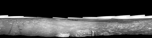
Thanks for this wonderful pano, mhoward.
Looking around and comparing it with Tesh's map, I am especially struck by the appearance of Sutherland Point beyond the dark bay to the Right of the rover mast. You can see some subtle undulating topography in it which is so slight, compared with the prominent ridge appearance in the HiRISE map. Another example of how we were fooled by the orbital photos into thinking these crater rim features were much, much taller than they really are. How they can appear so prominent from above, yet be so negligible from gound level, is still pretty mystifying...
This is a "lo-fi" version of our main content. To view the full version with more information, formatting and images, please click here.