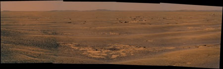
Hmmm... As Tesheiner said, we've climbed out of the low we'd been in, and we can now see the near rim pretty much all the way to the dark crater on the far wall (maybe someone could think of a name for this?). No sign of Cape York - I'm afraid it may be inside Endeavour a ways.
There's still plenty of Endeaour to see, and it still looks like once we make it to the near horizon (something like a km away??) we should get a stunning view.
Full Version: Distant vistas
A closer look at the craters of Endeavour...
http://roadtoendeavour.wordpress.com/2010/...rs-of-endeavour
http://roadtoendeavour.wordpress.com/2010/...rs-of-endeavour
QUOTE (kenny @ Aug 14 2010, 09:46 AM) 
And for any of our readers who do not speak Scottsh Gaelic, a brae (properly braigh) is the upper part of a slope...
(Interesting linguistic aside - brae/brea is also found in Cornish (Brythonic Celtish), as in Carn Brea, a Neolithic hilltop site in West Cornwall, UK - http://maps.google.co.uk/maps?ll=50.221746...;t=h&hl=en)
QUOTE (Stu @ Aug 22 2010, 08:22 AM)
A closer look at the craters of Endeavour...
Wonderfully illustrated Poet Dude.

Jack
So I dug into the latest PDS release of MER data and surfaced with the first really good look at those distant hills, coinciding with the start of this thread, which was part of the Concepcion pan taken on sol 2140. There isn't another good Pancam view in that PDS release (which ends with sol 2160). Do I have things labeled correctly here?
EDIT: Fixed attribution of Cape Trib -- thanks for the correction James.
EDIT: Fixed attribution of Cape Trib -- thanks for the correction James.
Sol 2337. Not easy to manage the black area of the last frame of this pano (take the L2 layer to made an artficial L7... seriously man).
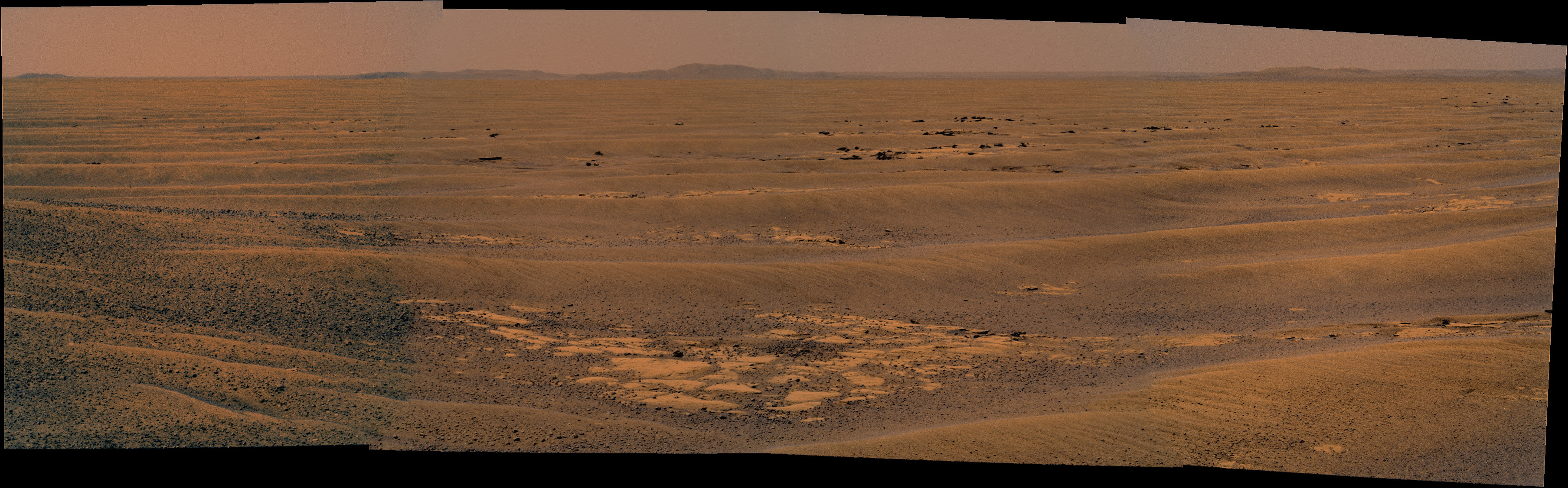
Hadn't noticed the crater on the wall of that mountain until Stu pointed it out in the blog. Comes out quite well in your mosaic, Ant. Going to be watching that as we get closer 
Starting to look like the stretch run! Thanks as always for the color commentary, Stu!
Thanks Brellis. Yep, really nice view of the crater there Ant... I am really looking forward to seeing the other craters on that bombarded far rim come into view.
I wish they'd give that crater a name... my suggestion would be:
"Monkhouse Crater", after Midshipman Jonathon Monkhouse.
Why? Because he saved the Endeavour...
From the website: http://reocities.com/athens/delphi/5600/cookbook.htm
"Cook was understandably much more worried about saving the ship itself; and his main problem was the expedition-threatening leak in the Endeavour's hull. Jonathan Monkhouse, one of Cook's midshipmen, suggested a way to at least control the leak a technique called "fothering". Monkhouse had once seen it used on a voyage from Virginia to London, and Cook promptly put him in charge of applying his knowledge to the Endeavour.
Cook reports:
"He took a lower studding sail, and having mixed together a large quantity of oakham and wool, chopped pretty small, he stitched it down in handfuls upon the sail, as lightly as possible, and over this he spread the dung of our sheep and other filth . . . . When the sail was thus prepared, it was hauled under the ship's bottom by ropes, which kept it extended, and when it came under the leak, the suction which carried in the water, carried in with it the oakham and wool from the surface of the sail, which in other parts the water was not sufficiently agitated to wash off. "
The operation was a success, and the dangerous leak was much reduced. (Incidentally, oakum Cook's "oakham" is loosely twisted rope fibre that has been impregnated with tar and is used for caulking seams in wooden hulls.) "
I've submitted this suggestion, but no response yet. (Maybe Rui's already reserved that crater to be named after the ship's cat, or the reference to "dung of our sheep and other filth" put them off! )
)
Yep, really nice view of the crater there Ant... I am really looking forward to seeing the other craters on that bombarded far rim come into view. I wish they'd give that crater a name... my suggestion would be:
"Monkhouse Crater", after Midshipman Jonathon Monkhouse.
Why? Because he saved the Endeavour...
From the website: http://reocities.com/athens/delphi/5600/cookbook.htm
"Cook was understandably much more worried about saving the ship itself; and his main problem was the expedition-threatening leak in the Endeavour's hull. Jonathan Monkhouse, one of Cook's midshipmen, suggested a way to at least control the leak a technique called "fothering". Monkhouse had once seen it used on a voyage from Virginia to London, and Cook promptly put him in charge of applying his knowledge to the Endeavour.
Cook reports:
"He took a lower studding sail, and having mixed together a large quantity of oakham and wool, chopped pretty small, he stitched it down in handfuls upon the sail, as lightly as possible, and over this he spread the dung of our sheep and other filth . . . . When the sail was thus prepared, it was hauled under the ship's bottom by ropes, which kept it extended, and when it came under the leak, the suction which carried in the water, carried in with it the oakham and wool from the surface of the sail, which in other parts the water was not sufficiently agitated to wash off. "
The operation was a success, and the dangerous leak was much reduced. (Incidentally, oakum Cook's "oakham" is loosely twisted rope fibre that has been impregnated with tar and is used for caulking seams in wooden hulls.) "
I've submitted this suggestion, but no response yet. (Maybe Rui's already reserved that crater to be named after the ship's cat, or the reference to "dung of our sheep and other filth" put them off!
)
Emily: It should be Cape Tribulation rather than Cape Byron, Cape Byron is just visible in between Cape Tribulation and Cape Dromedary. You could also add Batavia which is visible on the left edge of Cape Trib.
Stu: But that would break with the tradition of naming craters after ships. I'd suggest 'Lord Sandwich' as Endeavour was renamed later in life (although this still breaks the naming rule as it wasn't used a a ship of exploration under that name)
Stu: But that would break with the tradition of naming craters after ships. I'd suggest 'Lord Sandwich' as Endeavour was renamed later in life (although this still breaks the naming rule as it wasn't used a a ship of exploration under that name)
Emily, there's just another Pancam series on sol 2160 (at the end of that sol) http://an.rsl.wustl.edu/mer/merbrowser/pro...RDABCXP2378L6M1, though only L6s, if you are looking for multicolor.
Quite an improvement to http://qt.exploratorium.edu/mars/opportuni...CXP2378L6M2.JPG
Quite an improvement to http://qt.exploratorium.edu/mars/opportuni...CXP2378L6M2.JPG
QUOTE (jamescanvin @ Aug 25 2010, 08:28 AM)
Stu: But that would break with the tradition of naming craters after ships.
Yep, I know, and I thought about that, but it would be so... well... fitting: that crater is a hole in Endeavour, and that Midshipman helped fix a hole in the ship Endeavour... Cook praised his efforts in his journals. What a great gesture that would be, for NASA to honour the work of a humble midshipman, who helped save one of the most famous ships of exploration in history, by naming a crater on an alien world after him, a crater inside the crater that bears the name of the very ship the sailor saved, all those years earlier. I love that idea, I just love it.
Think of the Outreach value of that...
Thanks, James! I've fixed the attachment, adding in Batavia and correcting to Cape Trib.
Thanks, Tman -- I am hoping that I will find enough color pans to work with, but I'll check how things look after the next PDS release and will use that L6 horizon sequence if it fills a noticeable gap in the development of the hills.
Thanks, Tman -- I am hoping that I will find enough color pans to work with, but I'll check how things look after the next PDS release and will use that L6 horizon sequence if it fills a noticeable gap in the development of the hills.
I'm not sure... at all!... but I think that Ant's latest beautiful panorama offers us a glimpse of more features on the farside of Endeavour...
Too many pics to post this here, so I hope some of you will wander over to my blog to see if I'm right...!
http://roadtoendeavour.wordpress.com/2010/...-on-the-far-rim
Too many pics to post this here, so I hope some of you will wander over to my blog to see if I'm right...!
http://roadtoendeavour.wordpress.com/2010/...-on-the-far-rim
Quick question: Am I correct in my understanding the last decent view of the 'twin peaks' on Endeavour's north rim that we've seen were captured within a month or so of FredK's opening post in this thread? If not, none of my searching today has produced any fruit in finding anything more recent.
I started down my wild goose chase while guessing that the "Twin Peaks" might be the longest roughly continuously visible (maybe better 'most enduringly visible'), in spite of the seeming recent dearth of sightings of late. To my knowlege, they were first sighted in early April 2006 here, and ID'd as part of Endeavour no later than late September of the same year here. As we near October, that will mark four and a half years. I can't think of any other identifiable features on our horizon here that exceeds that. Even the first and last hints of Victoria and Endurance were visible for less than four years I believe.
Anyway, I look forward to any sightings of TP that I have missed, and any other corrections / thoughts others might have!
Cheers from Virginia!
-- Pertinax
The north rim peaks have been spotted regularly - the latest I have is sol 2333:
http://marsrovers.jpl.nasa.gov/gallery/all...00P2389R1M1.JPG
http://marsrovers.jpl.nasa.gov/gallery/all...00P2389R1M1.JPG
I had a junior league question about elevation, and I am proud to report that by searching "elevation" and "endeavour" I arrived at fredk's Post #10, which contains a nice graph of Oppy's vertical journey!
edit: posts around #10 further inform the inquiring mind!
edit: posts around #10 further inform the inquiring mind!
Phil's Post #81 in the Marquette Island thread has a wonderful attachment that further illuminates the searching mind.
http://www.lpi.usra.edu/meetings/lpsc2010/pdf/2638.pdf
Thanks again to the folks on the front line with Oppy and Spirit
from the pdf:
That answers my junior league question.
http://www.lpi.usra.edu/meetings/lpsc2010/pdf/2638.pdf
Thanks again to the folks on the front line with Oppy and Spirit
from the pdf:
QUOTE
Opportunity begins a
descent down an 80m slope toward Endeavour crater,
much of it containing broad outcrop exposures. These
exposures exhibit subtle festoon banding that may be
exposed edges of sub-horizontal bedding on this slope,
or onlaps of material onto pre-existing topography.
descent down an 80m slope toward Endeavour crater,
much of it containing broad outcrop exposures. These
exposures exhibit subtle festoon banding that may be
exposed edges of sub-horizontal bedding on this slope,
or onlaps of material onto pre-existing topography.
That answers my junior league question.
I have tried to add the contour lines from the topographic map shown in the article mentioned above to the high resolution map used in the route map as a tool to help me figure out when we are going to see the really cool distant vistas. Please note that this map is quite crude. I am working from what looks like a fairly crude topo and my hand with a mouse is not the steadiest. I am most confident about the placement of -1395 and -1400. I am sure there are those here who could do better.
Click to view attachment
It appears that grade steepens at about -1395, though I lot of ups and downs can hide in a 5 meter contour. My crude calculations indicate that it will be about a 2% grade; not much, but a lot mare than we have seen out here on the plains. I have been for some time now expecting a 'heck of a view" once we get to the bare area around -1395 or beyond. I guess we will see soon. Actually, I am looking forward to see what the local topography looks like as well. I feel a defining panorama coming up soon.
Some time ago ESA had a press release on The first hiking map of Mars. (I am still waiting for copy of the "Mars Gazetteer," full of 'hiking' topo maps of the entire planet.) I really wish they would get on with producing a map like that of this region of Meridiani Planum. It would make our back-seat exploring a bit more fun.
Just a reminder that a much better version of that contour map is available here.
Was the topo created by extrapolating from a very large scale? It looks to me like none of the rim hills even register on the map.
QUOTE (Stu @ Aug 25 2010, 06:08 PM)
I'm not sure... at all!... but I think that Ant's latest beautiful panorama offers us a glimpse of more features on the farside of Endeavour...
Too many pics to post this here, so I hope some of you will wander over to my blog to see if I'm right...!
http://roadtoendeavour.wordpress.com/2010/...-on-the-far-rim
Too many pics to post this here, so I hope some of you will wander over to my blog to see if I'm right...!
http://roadtoendeavour.wordpress.com/2010/...-on-the-far-rim
OK Stu, here is what I reckon.
First of all, when it comes to subtle features like these I find it best to stick with the greyscale images and preferably not use ones reprojected into a pan. Even better, it is the red channel which shows the relief better and happily we have two of those - L2 and R2, so they can be stacked.
I (obviously) agree with 'A' ("Monkhouse"
 ). 'B' looks good too. But I don't think you've got 'C', I think that crater is too far inside Endeavour to be seen (yet!) and I don't think it aligns quite either.
However you missed the clearest new feature - The little crater to the right and slightly further down the Endeavour crater wall is just peeking over the near horizon.

Here is the sol 2337 L2/R2 stacked and enhanced, with the new crater marked.
Click to view attachment
James
Thanks very much James, I knew I could rely on you to set me right. Appreciate it!
How the ???? did I miss that other crater? (smacks head on wall.. and again... and again...)
How the ???? did I miss that other crater? (smacks head on wall.. and again... and again...)
QUOTE (Floyd @ Aug 26 2010, 07:09 AM)
... It looks to me like none of the rim hills even register on the map.
The map is interpolated from MOLA data points which are spaced spaced several kilometers apart. Many of the rim hills were missed by the original MOLA measurements and therefore do not show up in maps derived from those measurements. This is the same reason the hills are underrepresented by the elevations in Google Mars.
QUOTE (jamescanvin @ Aug 26 2010, 10:29 PM)
I (obviously) agree with 'A' ("Monkhouse" ). 'B' looks good too. But I don't think you've got 'C', I think that crater is too far inside Endeavour to be seen (yet!) and I don't think it aligns quite either.
). 'B' looks good too. But I don't think you've got 'C', I think that crater is too far inside Endeavour to be seen (yet!) and I don't think it aligns quite either.I think you're right about "C". But I think I've identified what that really is. What do you think of this interpretation then, James?
Click to view attachment
It is mind-blowing to see that distant crater on the inner slopes of Endeavor's far side.
I can't recall another image from the surface of Mars where a big crater is nearly fully visible on the distant horizon. At best we would see just the rim and perhaps a few glimpses of the inner cliffs of the far side, but never the bottom of the crater as we can see now far across this Mars-scape.
This is a first in some way, isn't it? (My apologies if this has been discussed already.)
QUOTE (Stu @ Aug 27 2010, 06:29 AM)
What do you think of this interpretation then, James?
I don't think so, the alignment of that feature is pretty close to the crater you originally pointed, your new one is a long way away from that. First thing to be wary of, is that that feature is very close to the edge of two frames in Damien's pan (hence why it is just off the edge of my image) so it's even more dangerous to use it for this type of work. While saying that, I did have a look at the raws last night when I was working on this to check and did see a bit of a dark smudge. However, there are many dark spots in my image, particularly near the peaks of hills. I think these are just indicating steeper slopes and don't generally show up well on the orbital image; I think this is what you are seeing here. I didn't see anything obvious for that feature when i had a quick look last night, and a glance across the left portion of my image shows how difficult it's going to be matching every feature we can now see.
I should note before anyone spends too much time looking at the image I posted, that I didn't reproject the orbital image for the current position but used the one I had from Conception. Hence it is not a perfect match and I think the orbital image should, to first order, be stretched slightly for a better match to account for us being slightly closer now. When I get the chance I'll start from scratch and make a more accurate/better version.
James
Thanks James, appreciate you taking the time to comment and to check. I'm probably being a bit impatient. Just so exciting to see new features come into view, and wonder what they'll look like closer up...
QUOTE (Floyd @ Aug 26 2010, 06:09 AM)
Was the topo created by extrapolating from a very large scale? It looks to me like none of the rim hills even register on the map.
This is one of my pet peeves -- too many people interact with the MOLA data set through the relatively low-resolution gridded data products (and the contour maps calculated from them) rather than by going directly to the source, ground-track topographic profiles, which contain much more detail. Rather than just express my annoyance at this I went through the work of creating a Google Mars KML file containing MOLA ground tracks (attached) for the Opportunity landing site, so you can look at them all yourselves. Here's a blog entry explaining how to do this for your own favorite spot on Mars.
You'll find by looking at that that, indeed, Cape Tribulation and Cape Byron are both nestled in between MOLA ground tracks, so do not show up on the gridded data product. Cape Dromedary, however, is crossed by a ground track, as is Batavia (by two!)
I'm getting an "error 404 - file not found" attempting to access the KML file both from this link and from the one in the blog. 
Sorry! Attached it to the original post...the file is there so I am not sure why our website isn't serving it properly.
It works for me and is quite informative! thanks Emily
Thanks for that Emily, those plots are useful. One thing that might make the "Oppy Journey" plot even more useful would be markers at a few milestones along the route, such as Erebus, Concepcion, or something similar. (Victoria is pretty obvious.) With the understanding that this would be only crude, since the samples don't coincide exactly with the route.
Also, would it be possible to extend that plot with the few data samples along the projected route we've been following? Of course that's only projected, but it would give us some idea of what's to come.
Also, would it be possible to extend that plot with the few data samples along the projected route we've been following? Of course that's only projected, but it would give us some idea of what's to come.
QUOTE (fredk @ Aug 28 2010, 07:00 AM)
Also, would it be possible to extend that plot with the few data samples along the projected route we've been following? Of course that's only projected, but it would give us some idea of what's to come.
I think that's exactly what's on the first graph (named "Opportunity's topographic journey from MOLA shot data") in Emily's article. Check the diamond-shaped plots.
The diamond path "future path across MOLA tracks" extends to total distance 22km, which is our current odometry. So does that mean the horizontal axis ("straight line distance") is as-the-Martian-crow-flies from landing? Perhaps I was stumped by the coincidence that that crow-flies distance at Endeavour is the same as the current odometry?
Thank you Emily, this give more perspectives and more feeling that we're on flat terrain.
Assuming we'll ever climb Cape York, the "Distant vistas" will better appear but I don't think we'll feel to be on the rim of a crater looking down inside. From Mola's we'll be then around -1400 and the lowest point inside the crater I could find is -1971 but it's near the other side of Endeavour and may be not visible from Cape York. We'll have "-1600's" in the near distance but I don't think we'll have the same feeling of been on a summit like Spirit when she was on the "Everest". Flat terrain it is.
Assuming we'll ever climb Cape York, the "Distant vistas" will better appear but I don't think we'll feel to be on the rim of a crater looking down inside. From Mola's we'll be then around -1400 and the lowest point inside the crater I could find is -1971 but it's near the other side of Endeavour and may be not visible from Cape York. We'll have "-1600's" in the near distance but I don't think we'll have the same feeling of been on a summit like Spirit when she was on the "Everest". Flat terrain it is.
Hope I don't sound too clueless, but what do the unlabeled lines represent?
The straight-line distance is along orbital tracks -- Opportunity's wheels have rolled much more than that as she's twisted and turned and rolled up to targets. I'll post a map guide if I have time this weekend.
Dan, I only turned on the labels for two representative ground tracks because to turn them all on totally covers the opening view with numbers and slows down your computer. Open the folder "MOLA shot points" (click the plus sign next to it) and turn on as many labels as you like. I've sorted the tracks in order -- all the ascending (yellow) tracks from west to east, followed by all the descending (orange) tracks from west to east.
Dan, I only turned on the labels for two representative ground tracks because to turn them all on totally covers the opening view with numbers and slows down your computer. Open the folder "MOLA shot points" (click the plus sign next to it) and turn on as many labels as you like. I've sorted the tracks in order -- all the ascending (yellow) tracks from west to east, followed by all the descending (orange) tracks from west to east.
This is really awesome Emily. Thanks for taking the time to put it all together.
Fred, maybe this will help.
Yeah, those look great, thanks Emily.
Latest drive topped a local rise and reveals an additional 'horizon' in the middle distance. Could be part of the parking lot terrain. There are some subtle bumps along it or possibly behind it south of the rimshot crater, Cape York?
Click to view attachment
Click to view attachment
Here're some further data I gathered with Google Earth.
Cape York should be in the same line of sight as the crater and spanning 5 deg. to the right. Santa Maria should be 15 deg. left of the crater.
Cape York should be in the same line of sight as the crater and spanning 5 deg. to the right. Santa Maria should be 15 deg. left of the crater.
So, we can see Santa Maria !!!?
No, I don't think so. I'll see what i can do when at home later, but I can't see anything in the raws.
It does look like we can now see part of the parking lot. My gut feeling is that Santa Maria is still below the near horizon (and that the bit of the parking lot we can see is beyond it) So I wouldn't be surprised to see it pop into view any sol now.
It does look like we can now see part of the parking lot. My gut feeling is that Santa Maria is still below the near horizon (and that the bit of the parking lot we can see is beyond it) So I wouldn't be surprised to see it pop into view any sol now.
From what I can tell we are going to get a nice new view within the next 250-500 meters. If there is going to be an early glimpse of Cape York, that will be when. If we don't see it within 500 meters of where she sits now, then it's going to be a really long time before we do.
Thanks. I completely agree. Moreover Santa Maria must be more on the left (north).
James, I think it's time to post one of those "re-projected" images again.
This is a "lo-fi" version of our main content. To view the full version with more information, formatting and images, please click here.