Help - Search - Members - Calendar
Full Version: Distant vistas
Unmanned Spaceflight.com > Mars & Missions > Past and Future > MER > Opportunity
Pages: 1, 2, 3, 4, 5, 6, 7, 8, 9, 10, 11, 12, 13, 14, 15
ngunn
[quote name='Bill Harris' date='Mar 20 2010, 12:28 PM' post='157397']
Post#

206 FWIW smile.gif
Can anyone with Google Earth Mars confirm whether HRSC is indeed currently the most detailed orbital imagery of the SE Miyamoto rim? I'm guessing it is since I haven't seen anything else posted.
fredk
We really were on a bit of a ridge at Concepcion. The view of Endeavour etc has worsened considerably since then:
Click to view attachment
This should be temporary, though, and the view should improve again eventually...
Tesheiner
Ngunn, I can't speak about HRSC.
But here's the map of HiRISE pictures covering the same area that you can find on this link: http://global-data.mars.asu.edu/
Click to view attachment
There's coverage to the east of Miyamoto, also some of Bopolu but none of the rim.

QUOTE (fredk @ Mar 20 2010, 04:27 PM) *
The view of Endeavour etc has worsened considerably since then...

Nice work, fredk!
I expect that once we leave the twin craters --only a few hundreds of meters after, perhaps-- the view will get much better than the one we had at Concepción.
djellison
There's just about complete CTX coverage of the whole of Miyamoto. Turn on the CTX imagery in Google Earth(mars), and you're ready to rock.
ngunn
Great, but I don't have Google Earth Mars. Could somebody post the CTX of those rim peaks?
djellison
There is raw data available, but map projected stuff isn't available (and it's not particularly hard, but it is fairly time consuming to make it)

http://viewer.mars.asu.edu/planetview/inst...I_04S006W#start
http://viewer.mars.asu.edu/planetview/inst...1786_XI_01S006W
http://viewer.mars.asu.edu/planetview/inst...I_03S005W#start

A starter for 10 smile.gif

HRSC offers the best stereo usually ( unless a HiRISE or CTX dem exists ) - but CTX imagery is far FAR better than HRSC imagery.
ngunn
Well, there they are in the middle one. smile.gif Thanks Doug. Now - 3D?
ngunn
Are you there Nirgal? smile.gif
Here's the area of interest cropped from the browse version. The original has MUCH more detail.
ngunn
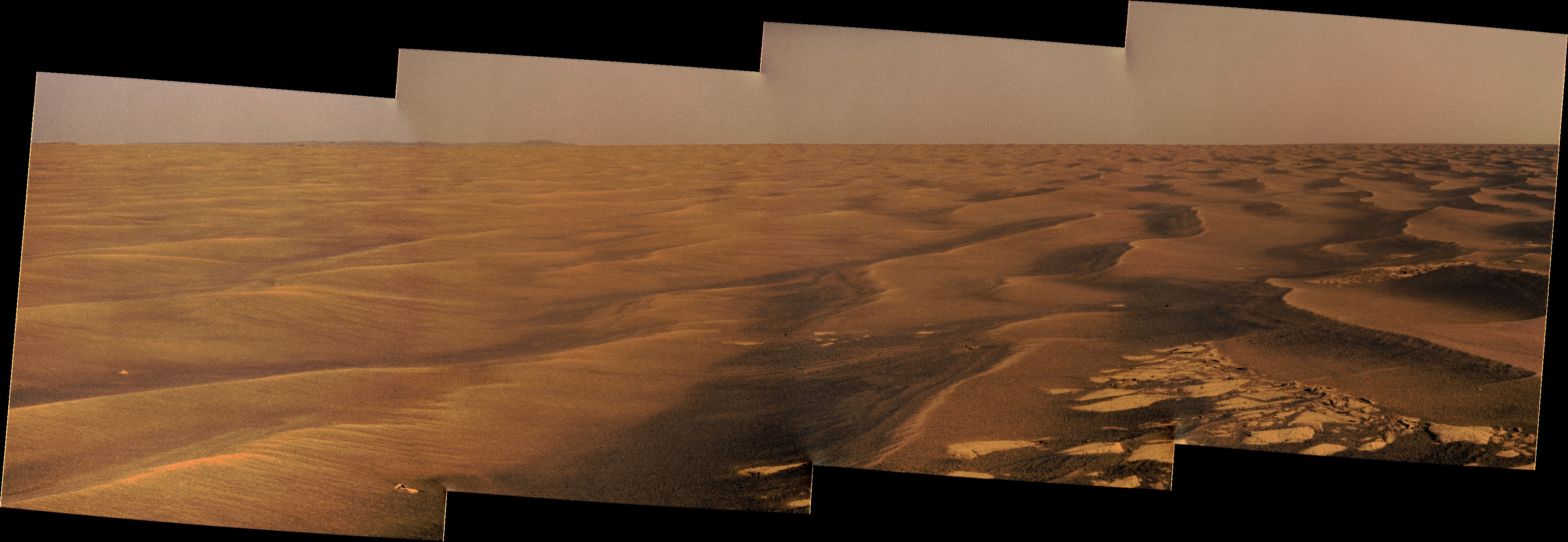
OK we have the Mule Ears identified, but that still leaves 'Rockaway', the nearer feature to the right of them. We've been assuming it's quite close, therefore small, therefore (since it's off the edge of the HiRise) probably unidentifiable with only CTX. However I've been monitoring small changes in the angular separation of the Mule Ears and 'Rockaway' as we move south. The results of some extremely crude and approximate calculations surprised me. I came up with a distance of 9 kilometres. This would make it's diameter about 60m, which should be easy to find on CTX. So I looked for the CTX and checked out what lies about 9km away on a bearing of 198 degrees. Not too far from that position - lo and behold - a small dark spot which appears to have rays. Now I'm only looking at a browse version of the CTX, plus my measurements and calculations are as I say very rough, so I'd appreciate if someone else could check this out.

This would mean the flat horizon we are seeing in front of the Mule Ears and Bopolu is probably Mars-curvature limited, not topography limited, consistent with the contour map. (When I thought 'Rockaway' was much nearer it bothered me that there should be no hill there for it to sit on.)

http://photojournal.jpl.nasa.gov/jpeg/PIA11837.jpg

EDIT It's at the centre of this crop:
fredk
I agree with your ID of "rockaway". Here's a closer view of it - it looks pretty fresh:
Click to view attachment
Both the azimuth and the size look right. This crater would subtend about half a degree from our current location, which is what we see. The distance also looks believable, since the horizon on either side of it looks very flat, which suggests it's very far away.
Tman
Yes, the azimuth heading matchs perfectly in your image. Great finding! The rim must be pretty developed.
I have an "not suitable for measurements" image with better resolution" that I'dont know from where it came onto my disk". Here the detail:

Click to view attachment
Tesheiner
Looking to the vertical strips on the image I would say that it looks like from CTX.
ngunn
Anyone got the actual distance measured? I only know it approximately from laying a plastic ruler on my monitor screen and using the size of Victoria as a guide.
fredk
About 7.5 km from current location to rockaway.
ngunn
Thanks smile.gif
Tesheiner
QUOTE (Tman @ Mar 23 2010, 07:41 PM) *
I have an "not suitable for measurements" image with better resolution" that I'dont know from where it came onto my disk". Here the detail:


After reading the latest blog entry from Emily@TPS pointed by Explorer1 at the Concepción thread, I rushed to the HiRISE website to search for the whole picture used at the article and with the following idea in mind: "maybe the 'rockaway' crater is visible on that picture". This new HiRISE image (link here) cover much more land to the left then previous ones, way west of the twins, but unfortunately it misses rockaway by a small fraction.
Here's an image crop at browse resolution to compare with the one used in your post.
Click to view attachment
Stu
Today's vista...

Click to view attachment
RokitSiNTst
Stu, there is another on the horizon of this image 1N323231461EFFAEI4P1977R0M1.JPG (Bopolu, plus the other twin peaks)
ngunn
QUOTE (RokitSiNTst @ Mar 30 2010, 11:11 PM) *
the other twin peaks


Which features are you referring to here and where are they in the image?
Ant103
In colors
RokitSiNTst
Twin peaks II (Miyamoto crater?) far right, another small crater center.
Click to view attachment

Twin Peaks II (Miyamoto crater?) far left, Bopolu(?) just to the right of them.
Click to view attachment


4x vertical stretch.
fredk
Close. What you're calling Twin Peaks II is part of Bopolu. Your "small crater" is Rockaway. The "Mule ears" aren't visible in navcam.
ngunn
The clearest view yet of the Mule Ears, and maybe one of the last for a while as we're now facing eastward.
http://qt.exploratorium.edu/mars/opportuni...00P2409R1M1.JPG

I think I can see the notch in the right one that also shows in James's Google view:
http://www.unmannedspaceflight.com/index.p...st&id=21125
ngunn
The distant southern horizon looks surprisingly curved now:
http://qt.exploratorium.edu/mars/opportuni...TQP2413R1M1.JPG
Is this the effect of the regional downslope to the SE ?
Phil Stooke
There's only one way to investigate that... astigmovision:

Click to view attachment

Looks like we will see some details on the plains if the air clears more, or when we have the raw data. The relief is starting to show up well.

Phil
ngunn
Vertical stretch of the curved horizon: EDIT You beat me by 4 minutes Phil!
Tman
In the adjacent image to the left the plain becomes also visible behind the dune field: http://qt.exploratorium.edu/mars/opportuni...TQP2413R1M1.JPG

Ohh uhh: http://qt.exploratorium.edu/mars/opportuni...TQP2413R1M1.JPG

Very nice and additionally a new remote (?) crater puzzle smile.gif

Click to view attachment
Phil Stooke
All three frames put together.

Phil

Click to view attachment
ngunn
Very nice, Phil. I suppose the most distant part of the flat horizon now coming into view must actually be a fraction of a degree below the theoretical horizon, which ought to be closer in level to the plateau on the right. I'm not used to such views because all the large regional dips in my part of Terra are full of seawater.
fredk
Great views! We're already seeing a bit more of Iazu than we did at Concepcion, and as Phil's stretch shows, we still haven't cleared the ridge up ahead.

The perspective has changed substantially since Concepcion. Here's a long-baseline anaglyph combining sol 2160 (Concepcion) and 2215 views. The dark bits in front of Iazu clearly stand out in front:
Click to view attachment
fredk
QUOTE (Tman @ Apr 19 2010, 01:01 PM) *
Very nice and additionally a new remote (?) crater puzzle

The new bit you're referring to (near azimuth 155 on your horizon mosiaic) looks hazier than Iazu, so presumably farther away. My guess is we're seeing a bit of the rim of the big crater behind Iazu, marked with the white arrow in this view:
Click to view attachment
ngunn
I agree. Another peak-matching exercise for James. smile.gif. Does it have an official name? (Looking forward to viewing your Iazu anaglyph when I get home to a computer that doesn't mess up the colours.)
vikingmars
QUOTE (Phil Stooke @ Apr 19 2010, 01:06 PM) *
There's only one way to investigate that... astigmovision: Click to view attachment Phil
Phil, your image reminds me Goldstone as seen from VL2... Same "Philovision", but different landing site ! laugh.gif
Phil Stooke
Ah yes, good times... good times.... the old Viking days.

Phil
Burmese
marsroverdriver today:

"Keep an eye on http://marsrovers.jpl.nasa.gov/gallery/all/opportunity.html for when B-2215 (Oppy weekend drive) images show up: PANCAM got nice images of Endeavour on far horizon"
ngunn
Finally the distant southern skyline is fully revealed, all the way from Iazu to the Mule Ears.
http://qt.exploratorium.edu/mars/opportuni...cam/2010-04-21/

EDIT: And in the third image, near the bottom of the slope down from the 'rockaway plateau' to the lower plains, there are a few dark pixels close to the horizon whch could be another middle-distance fresh crater. A wild guess: there is another dark spot about 5 km SE of Rockaway here:
http://www.unmannedspaceflight.com/index.p...st&id=21169. That one should be on the Hirise I think.

I've pointed to the feature here:
nprev
Odd but evocative to see surface relief rising more rapidly now from Oppy's viewpoint. It's a bit like driving across the North American Great Plains & approaching the Rockies.
Astro0
Panorama
Click to view attachment

and...

some extreme Phil-O-Vision
Click to view attachment
Tesheiner
The view is becoming really beautiful.
I'm wondering if it will be possible to see Santa Maria (mini-Endurance) once we are clear of this local high point.
Stu
Wow... I come home from work, log on and see... The Future... smile.gif

I haven't been as excited by such a view since we first peered over the edge of Victoria Crater.

And I have to be honest... seeing the Hills from top to bottom like that, this is the first time I've actually, truly believed Oppy will eventually reach them.

Fanciful view - and please, no-one say "ooh, the Sun could never be there!" if the viewing geometry is wrong; it's just to evoke the sense of wonder I'm feeling right now... smile.gif

Click to view attachment

jamescanvin
QUOTE (Stu @ Apr 21 2010, 03:31 PM) *
And I have to be honest... seeing the Hills from top to bottom like that, this is the first time I've actually, truly believed Oppy will eventually reach them.


Reach Iazu? You're beginning to sound like Rui!
Stu
Speaking generally, James, not literally. smile.gif I think we're on for Endeavour, but that will be it.
Tman
QUOTE (Stu @ Apr 21 2010, 04:31 PM) *
and please, no-one say "ooh, the Sun could never be there!" if the viewing geometry is wrong...

Ok, I do not say "what is the height of the sun there about? 10 degrees? Then the southest azimuth point of the sun around in the early morning can be about 115 degrees for Oppy (at Ls 270°). Therefore probably more realistic with one of the peaks of Endeavour" smile.gif

Either way a nice "atmospheric" composition (of course).
Stu
smile.gif

One of my favourite Ansell Adams quotes is:

"Sometimes I do get to places just when God's ready to have somebody click the shutter."

My version:

"Sometimes Oppy gets to places when God's got the details just a little bit wrong, so I rearrange them"... laugh.gif
ngunn
QUOTE (Tesheiner @ Apr 21 2010, 03:21 PM) *
I'm wondering if it will be possible to see Santa Maria (mini-Endurance) once we are clear of this local high point.


My guess is yes, and quite soon. I'm expecting it to appear about twice the size of Rockaway and slightly below the (plains) horizon in front of Endeavour. I'm still getting my head round the fact that we're looking down on all this stuff and the theoretical horizon is up in the sky somewhere.
climber
QUOTE (Tesheiner @ Apr 21 2010, 04:21 PM) *
The view is becoming really beautiful.
I'm wondering if it will be possible to see Santa Maria (mini-Endurance) once we are clear of this local high point.

I have the feeling we'll have a kind of "Everest panorama" in the near future, yet different, but kind of same inspiration.
Ron Hobbs
I think you are absolutely right, climber, though I think it will be more reminiscent of northern Arizona or New Mexico. I think this will be one that would excite Ansel Adams.

(Not that the Everest pan wouldn't. laugh.gif )
Tesheiner
I'm really looking forward such panorama!
Meanwhile, I checked the tracking web for thisol and further imaging/driving plans and found this sequence planned for tomorrowsol (2220):

02220::p2415::24::6::0::0::6::1::13::pancam_Endeavour_movie_L257

Any ideas?
Stu
QUOTE (Tesheiner @ Apr 22 2010, 06:43 AM) *
Any ideas?


Maybe a pan of colour images, taking in the view all around..? Set to the theme from "The Big Country"? smile.gif
This is a "lo-fi" version of our main content. To view the full version with more information, formatting and images, please click here.
Invision Power Board © 2001-2024 Invision Power Services, Inc.