
Full Version: Distant vistas
Ah Dan. Didn't your parents warn you about playing with fire.
Cooks account of the discovery and naming of the original Cape York.
Which is part of a fabulous site transcribing and interlinking the main journals of the Endeavour Voyage. If anyones casting about for a good book to take on holiday, theres a brilliant narrative of the whole Endeavour expedition by Patrick Master and Commander OBrian in his biography of Joseph Banks.
Which is part of a fabulous site transcribing and interlinking the main journals of the Endeavour Voyage. If anyones casting about for a good book to take on holiday, theres a brilliant narrative of the whole Endeavour expedition by Patrick Master and Commander OBrian in his biography of Joseph Banks.
Fantastic resource phil, thanks for that! 
I guess we're not yet at the, how do we call it, look-out (?), I mean the place just before we'll go down. So, is there any chance to see Cape York from there? Anyway, another Official panorama from there will show us more features, not counting we'll be closer.
Has anyone posted a map of where Cape York is relative to Opportunity and Endeavor crater? I haven't seen it labeled on any of the maps yet. Maybe I've just missed it...
Take a look at my blog, there are lots of pics of where it is on there. Or, here you go...
Click to view attachment
Cape York is circled in yellow.
Click to view attachment
Cape York is circled in yellow.
A question: Can we already see Batavia in the superres? If not, why has it been singled out for naming ahead of more prominent far rim features such as 'Cook'?
I'm pretty sure Batavia is hidden behind Tribulation in the super-res. If it were visible, it should be lighter like Iazu, being a similar distance.
As far as why'd they name it, Batavia was visible earlier due to our changing viewpoint. Check out James' inverse polar from sol 2140 in this post.
As far as why'd they name it, Batavia was visible earlier due to our changing viewpoint. Check out James' inverse polar from sol 2140 in this post.
All this talk makes me want to visit the earthly counterparts of these places. Will probably start with Cape Byron as it's only 146km away.
It's gona take you 12000 days to get to there; good luck 
Discussion of the composition and formation of Cape York has been moved here
http://www.unmannedspaceflight.com/index.php?showtopic=6667
http://www.unmannedspaceflight.com/index.php?showtopic=6667
It looks like we can now see the plains behind Endeavour all the way around to this bit on the NE rim:
http://marsrovers.jpl.nasa.gov/gallery/all...NWP2362R1M1.JPG
There's only one stretch left before we can see the plains all the way across Endeavour...
http://marsrovers.jpl.nasa.gov/gallery/all...NWP2362R1M1.JPG
There's only one stretch left before we can see the plains all the way across Endeavour...
Combining two of the Endeavour movie frames (2247 & 2289) with an effective baseline of about 3-400m some stereo can be seen. As there isn't that much detail for your eyes to lock onto (combined with the noise as well) it's a little hard to see, but Cape Trib definitely appears closer than Dromedary and Hicks and Iazu is in the background.
Click image

James
Click image
James
Thanks for that, James. Unfortunately our direction of travel now isn't ideal for long-baseline imaging. But it sure is ideal for getting to Endeavour!
From latest TPS update: We wont be able to see Cape York until we get within a couple of kilometers of Endeavour, said Arvidson.
As Stu would say: discuss
As Stu would say: discuss
QUOTE (climber @ Aug 1 2010, 09:54 PM) 
From latest TPS update: We wont be able to see Cape York until we get within a couple of kilometers of Endeavour, said Arvidson.
Well... that weed on my chips, didn't it?

I prefer a bit of vinegar.
Phil
Phil
QUOTE (climber @ Aug 1 2010, 12:54 PM)
As Stu would say: discuss
Bah! I don't believe it. I say we'll see it before Santa Maria.
EDIT: Recent observations not withstanding, the spot where I previously predicted we'd likely see Cape York is about 1100 meters from the sol 2315 stop.
Um... is that the far rim of Endeavour on the horizon center?? Is this old news and I just haven't been paying attention? Anyway, amazing.
That's actually the plains beyond Endeavour. We can see them almost all the way across Endeavour now. In terms of the far rim itself, we can still only see some of the highest hills. It's easier to see what's going on with the L7/R1 images - check out the latest batch at:
http://marsrovers.jpl.nasa.gov/gallery/all...nity_p2318.html
http://marsrovers.jpl.nasa.gov/gallery/all...nity_p2318.html
Question: Is the curvature of the Mars globe such that there is no direct sightline between the tops of the far rims?
No - right now we can already see both sides, so they can certainly see each other.
Phil
Phil
Definitely. Compare them with the picture in the first post of this very same thread, here.
Perhaps in the near future we should open a new thread: (Not so) distant vistas.
Perhaps in the near future we should open a new thread: (Not so) distant vistas.
QUOTE
(Not so) distant vistas.
-------------
Distant Vistas - are we there yet?
coming soon -- the not so "Distant Vistas"
QUOTE (Tesheiner @ Aug 7 2010, 11:25 AM)
Definitely. Compare them with the picture in the first post of this very same thread,
You're not kidding!!!
http://twitpic.com/2cs1fs

Comparison animation between Aug.'09 and Aug.'10
Click to view attachment
OT - Just thinking about how far Oppy has come...
Aug. 2010 - on the road to Endeavour
Aug. 2009 - examining Block Island
Aug. 2008 - exiting Victoria Crater
Aug. 2007 - end of the Great Dust Storm
Aug. 2006 - examining Beagle Crater
Aug. 2005 - not long out of Purgatory on the way to Erebus
Aug. 2004 - inside Endurance Crater
Aug. 2003 - heading towards Mars
Since no one has yet posted this, I feel compelled to show a 5x sideways compressed version of Stu's above image (essentially similar to a vertical stretch).
There must be (probably) a vast shallow depression circling Endeavour, and combined with the fact that "we" are currently on a topographical high this is why we can see several kilometres beyond the big crater. I guess as we begin to descend to the lower plains already emerging from behind the near horizon, the far view across the crater will be gradually lost for us.
There must be (probably) a vast shallow depression circling Endeavour, and combined with the fact that "we" are currently on a topographical high this is why we can see several kilometres beyond the big crater. I guess as we begin to descend to the lower plains already emerging from behind the near horizon, the far view across the crater will be gradually lost for us.
QUOTE (marswiggle @ Aug 8 2010, 03:24 PM)
the far view across the crater will be gradually lost for us.
I think you're probably right, at least until we summit one of the rim hills!
QUOTE (Astro0 @ Aug 8 2010, 02:12 PM)
Comparison animation between Aug.'09 and Aug.'10
Beautiful!! That's what I wanted to do originally but ran out of patience - and profanities - trying to get the alignment right before I had to go to work...
QUOTE (Stu @ Aug 8 2010, 09:25 PM)
Beautiful!! That's what I wanted to do originally but ran out of patience - and profanities - trying to get the alignment right before I had to go to work...
You ran out of profanities? And you call yourself a poet and wordsmith.
Holy smokes. Thanks, Stu.
(we've been traveling so long ... and look! It's really there....)
(we've been traveling so long ... and look! It's really there....)
Today's view of the hills with only a modest stretch. No sign yet of Cape York.
Phil
Click to view attachment
Phil
Click to view attachment
That's surprizing. We can see the near rim on the right side of that frame (between near horizon and far rim hills). I make York to span roughly from the right side of that frame to below the dark crater about halfway up the far rim hill. The highest part of York should be the north (left) part. But there's no sign of a bump at all.
It's starting to look as though York is lower than the visible near rim, partway down into Endeavour. That would mean it could be a long time until we sight it.
It's starting to look as though York is lower than the visible near rim, partway down into Endeavour. That would mean it could be a long time until we sight it.
The terrain in the foreground has a slight rise on the left and dips to the right which is why we can see some of the near rim but not Cape York yet. Soon, very soon though. We are approaching a very subtle "summit" and once there, everything is going to pop into view.
We should be able to see both Cape Yort and Santa Maria once we reach this local high point and I think this "summit" is more or less located at the point the ripples disappear and we go into the bedrock pavement.
From the last TPS update:
Despite all the incoming Pancam pictures of Endeavours rim, Opportunity is still not able to see exactly where it will make landfall. We wont be able to see Cape York until we get within a couple of kilometers of Endeavour, said Arvidson. But we know where it is. We know its there.
Despite all the incoming Pancam pictures of Endeavours rim, Opportunity is still not able to see exactly where it will make landfall. We wont be able to see Cape York until we get within a couple of kilometers of Endeavour, said Arvidson. But we know where it is. We know its there.
QUOTE (ElkGroveDan @ Aug 13 2010, 12:04 PM)
We are approaching a very subtle "summit"...
And hopefully, wind-gusts-a-plenty on the brae after that...
so looking forward...
And for any of our readers who do not speak Scottsh Gaelic, a brae (properly braigh) is the upper part of a slope...
I agree there's a very subtle summit coming, but in the meantime, with the latest drive (2330) we've dropped into a subtle hollow (ancient eroded crater?). You can see a big change in the view from 2329:
Click to view attachment
This is the biggest change in view we've seen in a very long time. Maybe this topography is related to the big swaths of exposed bedrock we're approaching now.
Click to view attachment
This is the biggest change in view we've seen in a very long time. Maybe this topography is related to the big swaths of exposed bedrock we're approaching now.
Part of this comes from our slight tacking South where the slope dips a bit steeper. Nice to see validation of the terrain forms we've been working with though.
QUOTE (kenny @ Aug 14 2010, 02:46 AM)
And for any of our readers who do not speak Scottsh Gaelic...
Thanks for that clarification.
I've been thinking about trying to make a movie of the approach so far, and it occurred to me that this thread might be old enough that the first images posted to it may now be available in the PDS. I just checked the Analyst's Notebook, and they aren't--quite. But scheduled for Friday is the release of data through sol 2160. We should get better views from the PDS data -- we'll only be dealing with the haze from the atmosphere and the dust on the lenses, not the JPEG artifacts or the autostretch. It's time to start looking at the original distant vistas again, with sharper eyes!
Hi,
I'm back for processing again some pictures (I've taken a few vacations and it's hard for me te going back on Mars).
Sol 2320 pancam view
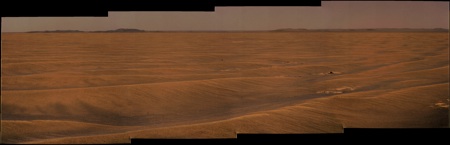
I'm back for processing again some pictures (I've taken a few vacations and it's hard for me te going back on Mars
).Sol 2320 pancam view

We must be near to the local high point. There's a lot of detail on the hills once again.
http://qt.exploratorium.edu/mars/opportuni...cam/2010-08-21/
http://qt.exploratorium.edu/mars/opportuni...cam/2010-08-21/
Stretched and pulled to within an inch of its life... fascinating, fascinating horizon...
Click to view attachment
Click to view attachment
This is a "lo-fi" version of our main content. To view the full version with more information, formatting and images, please click here.