I guess that's now the most distant bit of terrain we can see.
Phil
Full Version: Distant vistas
QUOTE (Phil Stooke @ Feb 12 2010, 03:48 PM) 
I guess that's now the most distant bit of terrain we can see.
...unless we spot a planet or one of the moons in the sky.
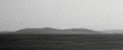
I was curious how the distance to Bopolu compares with the distance from Spirit to Gusev's rim, which is roughly 70 km if I'm right. I make the near rim of Bopolu to be about 58 km from Oppy. The far rim of Bopolu would probably be a bit farther than the Gusev rim from Spirit. So since we could easily see the Gusev rim when skies weren't too dusty, it's not surprizing that we can see out to Bopolu.
The new pancams from 2153 show more of Bopolu. Also the visibility is a bit better than on our first glimpse - I guess the dust has settled a bit. I've averaged the L7s and L5s, and pieced the frames together (the central strip is the average of all four overlapping frames):
Click to view attachment
Actual scale above, 3x vertical stretch below. This is still not the entire 18 degree extent of Bopolu...
Click to view attachment
Actual scale above, 3x vertical stretch below. This is still not the entire 18 degree extent of Bopolu...
Very nice, Fred! I hope it stays in view for a while, though it might become less visible when we are in the lower region east of here. Still, around the time we begin to descend we may get better views than this. Now we just need a really good atmospheric clearing! I was just looking back at the early views of Gusev's rim from the Columbia Hills - amazing views at times.
Phil
Phil
I see on Google Mars that Bopolu rim rises about 1000 feet above the local terrain, and the crater is about 5000' deep. Google Mars can reproduce the view along the horizon seen from Opportunity. Bopolu is the smaller double bump in the center (left of a larger bump).
Click to view attachment
Here's another view from much closer.
Click to view attachment
Click to view attachment
Here's another view from much closer.
Click to view attachment
What's the tasty morsel in the "upper right hand corner" at http://qt.exploratorium.edu/mars/opportuni...XP2373L7M1.JPG?!
The answer is just a few post before yours. 
That morsel is a bit of Iazu - compare it with the Iazu images earlier in this thread.
Ooops! Fredk is right.
I thought that image was pointing SW towards Bopolu but it's actually to the SE.
I thought that image was pointing SW towards Bopolu but it's actually to the SE.
There's a hill (maybe two) on the horizon to the left here. Is it one we've seen already?
http://qt.exploratorium.edu/mars/opportuni...66P2369L7M1.JPG
http://qt.exploratorium.edu/mars/opportuni...66P2369L7M1.JPG
That's Bopolu Crater. From these new images, I don't see any more bits of it compared with our last views, so this will be our best view for the time being.
QUOTE (Phil Stooke @ Jan 28 2010, 05:06 AM)
Ngunn, I was just about to say the same thing. The labels are not very clear, but the contours don't make sense any other way.
Phil
Phil
Sorry for the confusion about this, folks! The files got compressed so brutally when converting to a PDF format small enough to send, that even I can't read the numbers. Attached is the original figure. The "-1370" that was referred to is labeling an isolated line (right under the number). Sadly, Arcmap doesn't make such purdy contours!
The HiRISE wide baseline stereo pair over this region verifies the general aspects of the topography in the MOLA data, but of course is higher in spatial frequency. We are right on the NW edge of a small rise that's probably only a meter or so high and about 200 or so across. Once we finish with Concepcion and head south, we should start to see to the southeast better!
-Tim.
With respect to "Sadly, Arcmap doesn't make such purdy contours!", there are some techniques to improve contour output with ArcMap. This blog post has some tips:
http://blogs.esri.com/Dev/blogs/geoprocess...e-analysis.aspx
If you are using a terrain dataset (a multi-resolution TIN), it is generally recommended to convert the next to lowest pyramid level to a raster and then contour against that raster. It's a balancing act between technical accuracy and aesthetically pleasing contours. If you are using a TIN, same concept: convert the TIN to a raster and select a surface interpolation method depending on the character of the data. Then contour the raster. For "purdy contours", we nearly always make contours from rasters (DEMs), not TINs/terrain datasets.
If you direct me to that elevation data set, I could take a look at it and see what I could do with that data.
And for labeling contours, check out the Maplex Label Engine (go to the data frame properties > General tab > Label engine listbox). The laddering option works well for many situations.
Have you looked into making visibility maps from this data? That would be of interest to this forum.
regards, Michael Zeiler, ESRI
QUOTE (tim53 @ Feb 23 2010, 02:48 AM)
Once we finish with Concepcion and head south, we should start to see to the southeast better!
We are all looking forward that view.

Slightly OT but does the project has already a name for that "twin crater" 650m SSW of Concepción?
QUOTE (Michael Zeiler @ Feb 23 2010, 05:49 AM)
If you direct me to that elevation data set, I could take a look at it and see what I could do with that data.
I know some people who would love to put their hands on that data too. See here and here.
QUOTE (Tesheiner @ Feb 23 2010, 09:10 AM)
We are all looking forward that view.
Slightly OT but does the project has already a name for that "twin crater" 650m SSW of Concepción?
Slightly OT but does the project has already a name for that "twin crater" 650m SSW of Concepción?
Coff coff...
but more accordingly with the islands theme:
http://en.wikipedia.org/wiki/Twin_Island
QUOTE (Michael Zeiler @ Feb 22 2010, 08:49 PM)
With respect to "Sadly, Arcmap doesn't make such purdy contours!", there are some techniques to improve contour output with ArcMap. This blog post has some tips:
http://blogs.esri.com/Dev/blogs/geoprocess...e-analysis.aspx
If you are using a terrain dataset (a multi-resolution TIN), it is generally recommended to convert the next to lowest pyramid level to a raster and then contour against that raster. It's a balancing act between technical accuracy and aesthetically pleasing contours. If you are using a TIN, same concept: convert the TIN to a raster and select a surface interpolation method depending on the character of the data. Then contour the raster. For "purdy contours", we nearly always make contours from rasters (DEMs), not TINs/terrain datasets.
If you direct me to that elevation data set, I could take a look at it and see what I could do with that data.
And for labeling contours, check out the Maplex Label Engine (go to the data frame properties > General tab > Label engine listbox). The laddering option works well for many situations.
Have you looked into making visibility maps from this data? That would be of interest to this forum.
regards, Michael Zeiler, ESRI
http://blogs.esri.com/Dev/blogs/geoprocess...e-analysis.aspx
If you are using a terrain dataset (a multi-resolution TIN), it is generally recommended to convert the next to lowest pyramid level to a raster and then contour against that raster. It's a balancing act between technical accuracy and aesthetically pleasing contours. If you are using a TIN, same concept: convert the TIN to a raster and select a surface interpolation method depending on the character of the data. Then contour the raster. For "purdy contours", we nearly always make contours from rasters (DEMs), not TINs/terrain datasets.
If you direct me to that elevation data set, I could take a look at it and see what I could do with that data.
And for labeling contours, check out the Maplex Label Engine (go to the data frame properties > General tab > Label engine listbox). The laddering option works well for many situations.
Have you looked into making visibility maps from this data? That would be of interest to this forum.
regards, Michael Zeiler, ESRI
Hi Michael:
I will have to verify this when I get in to work in an hour or so, but I either used the gridded global data product from the Planetary Data System (will have to look up the actual link at work as well, but people here probably know what I'm referring to) - most likely - or I contoured the individual data points using the PDS' Orbital data explorer to create a shapefile of shot points within a lat/lon range. This latter option only became readily available about a year ago, so it's possible I didn't use it in this instance.
Thanks for the Arcmap suggestions. I've been slowly familiarizing myself with it's capabilities since I had to 'give up' on Canvas X when ACD Systems abandoned support for the Mac (and since it can't handle files over a GB in size).
-Tim.
QUOTE (Tesheiner @ Feb 23 2010, 01:10 AM)
We are all looking forward that view.
Slightly OT but does the project has already a name for that "twin crater" 650m SSW of Concepción?
I know some people who would love to put their hands on that data too. See here and here.
Slightly OT but does the project has already a name for that "twin crater" 650m SSW of Concepción?
I know some people who would love to put their hands on that data too. See here and here.
We'll probably try to swing buy this crater on our way to Endeavour. We usually don't name the craters until we're close to them or know we might visit them.
-Tim.
QUOTE (tim53 @ Feb 23 2010, 09:24 AM)
Thanks for the Arcmap suggestions. I've been slowly familiarizing myself with it's capabilities since I had to 'give up' on Canvas X when ACD Systems abandoned support for the Mac (and since it can't handle files over a GB in size).
-Tim.
-Tim.
Tim, I know it's a bummer to switch software. ArcMap has a rich set of capabilities, but it's a learning curve to master it all.
Contouring is a tricky proposition and the best technique depends on the nature of the data and striking a balance between technical accuracy and making pleasing contour curves. Label placement is another challenge.
Also, surface analysis can be done both with a DEM (digital elevation model, a raster with elevation values) or a TIN (triangulated irregular network). (A terrain dataset is a multi-resolution TIN optimized for huge point sets such as lidar point clouds). The people who do surface analysis work with both data structures and convert from one to another, depending on the desired map product or analysis they are trying to perform.
An aspect-slope map might be another good way to display the nature of this terrain. See http://blogs.esri.com/Support/blogs/mappin...-slope-map.aspx
This technique displays aspect (direction of slope) using a color hues and slope using saturation. This blog post outlines the individual steps, but I know that we've released a geoprocessing model that largely automates this whole process.
Another topic on interest on this forum is identifying distant features on the horizon. A viewshed map can easily help identify potential features visible from a point and this is relatively easy to make once you have a DEM. See http://webhelp.esri.com/arcgisdesktop/9.3/...ewshed_analysis
If you need technical assistance with ArcMap, you can contact me. If I don't know the answer, I know the experts who do.
- Michael
Well I had a pop at the viewshed before, but was kind of limited by the DEM I was using (75 m/px HRSC), and the fact that I hadn't lifted the view off the ground.
So here's the viewshed from Opportunity, from a few weeks back now, from 1.8 m above the ground. It doesn't look all that different to the ones I posted before to be honest.
Click to view attachment
And a possible view somewhere along the predicted path:
Click to view attachment
These don't take the curvature of the planet into consideration, as there's no easy way (to my knowledge) of changing the radius to that of Mars rather than the Earth (apart from fooling Arc with the original projection etc.). And switching on the curvature just for the hell of it does seem to make quite a difference in terms of what's visible on the horizon; that effect could be even greater for Mars then.
So there are my usual warnings not to take my distant vistas too seriously! I'm having a look at the aspect-slope map now - will post back if it works ok.
Pete
Well that didn't take too long
Here's the aspect-slope map of the same area as before (Victoria is left of centre at the top), made in exactly the same way as suggested in Micael's link.
Click to view attachment
It looks good, but I'm not sure that it helps too much in figuring out what we can see in the distance (due to resolution of DEM etc...).
Hmmm, I wonder what else I can use Arc for now...
Pete
QUOTE (pgrindrod @ Feb 24 2010, 01:06 AM)
Well I had a pop at the viewshed before, but was kind of limited by the DEM I was using (75 m/px HRSC), and the fact that I hadn't lifted the view off the ground.
Pete
Pete
Using the HRSC DEM is an excellent idea at low latitude sites, since the MOLA ground tracks can be a couple of kilometers apart at the equator. I've experimented with this data in other places, but not at Opportunity. I'll have to take a look at it, as the 75m spatial resolution is considerably better than the MOLA coverage there.
-Tim.
Yep, the HRSC DEM is good, but I'd still like a CTX one
Just to show what the underlying DEM looks like for all these viewsheds, here's a couple of coloured hillshades with contours (one with labels, one without). I haven't done anything fancy to make the contours, just whatever the default settings are in Arc. The green dot is Opportunity a few weeks ago.
Click to view attachment
Click to view attachment
Pete
QUOTE (pgrindrod @ Feb 24 2010, 04:06 AM)
These don't take the curvature of the planet into consideration, as there's no easy way (to my knowledge) of changing the radius to that of Mars rather than the Earth (apart from fooling Arc with the original projection etc.). And switching on the curvature just for the hell of it does seem to make quite a difference in terms of what's visible on the horizon; that effect could be even greater for Mars then.
I recall reading many years ago that if you tweak the refraction parameter appropriately, you can fool Arc about the radius of the planet. Sorry I can't give you a reference on that.
Steve M
After checking Google I found details on the ArcGIS help page.
Back in the olden days, before we had MOLA topography, and back when I was trying to anticipate what we might be able to see after Pathfinder landed, I looked at the visibility of distant objects at the Viking landing sites and realized that local topography is more important than the size of the planet, and submitted this abstract to LPSC:
-Tim.
-Tim.
Very nice view of the distant hills today...
http://qt.exploratorium.edu/mars/opportuni...CXP2378L6M2.JPG
http://qt.exploratorium.edu/mars/opportuni...CXP2378L6M2.JPG
QUOTE (tim53 @ Feb 24 2010, 11:23 PM)
Back in the olden days, before we had MOLA topography, and back when I was trying to anticipate what we might be able to see after Pathfinder landed....
-Tim.
-Tim.
Tim, I remember this paper very well and we had then a discussion with Cheick Diarra about the implications of seeing distant features and reprensenting them on maps for large public audience for the sake of our future Mars Outreach...
QUOTE (Phil Stooke @ Feb 25 2010, 08:06 PM)
Stu pointed to this image - here's a bit of a vertical stretch of it.
Phil
Phil
I have a question for the image processing whiz kids here. I've filtered the region above the horizon line with the standard 2d median in photoshop, which does a good job of removing the compression noise but smears the mountain peaks and valleys. Since the brightness of the horizon profile increases (roughly) monotonically with increasing elevation, it seems that a median filter applied along segments of single vertical columns centered on the pixel of interest would remove much of the compression noise without distorting the image significantly. Is anyone able to implement such a filter and apply it to our horizon profiles?
Steve M
I don't know about that... but here I've subtracted a high-pass-filtered version of the image above from the original. The HPF version was chosen to retain the small-scale mottling but suppress the rest. When it's subtracted this is what remains. A bit fuzzy but a lot cleaner.
Phil
Click to view attachment
Phil
Click to view attachment
Continuing to squeeze every bit of signal out of that L6 view of Iazu as possible, we have two versions of that image, M1 and M2. They are stretched quite differently, so the jpeg artifacts appear to be uncorrelated between them. So we can reduce the artifacts by averaging the two. Here's the result (after stretching the M1 version to match the M2), with 3x vertical stretch:
Click to view attachment
You can see that the bit on the right that was missing in M1 is noisier than the rest. A bit of smoothing happened during the rotation.
Click to view attachment
You can see that the bit on the right that was missing in M1 is noisier than the rest. A bit of smoothing happened during the rotation.
Very nice - I like those spiky hills at the right end.
Phil
Phil
Phil and Fred,
I didn't make myself clear, so here's a picture (worth a thousand words of clarification). This is a median filtered version of the original image, it nicely cleans up the compression artifacts but (as you can see) makes the peaks and valleys less jagged.
Click to view attachment
I think that if someone could implement a median that operated on vertical line segments (portions of a single column of the image) it would not round off the peaks and valleys and we could see them more clearly.
Steve M
This is certainly a view worth a little more tweaking.
Interesting to see the methods everyone is using.
Click to view attachment
Interesting to see the methods everyone is using.
Click to view attachment
I understand exactly what you mean, Steve, I just don't know how to do it!
Phil
Phil
Mathematically it's possible to calculate the distance from some 'mountain' top by measuring the angle it is protruding above the horizon (even it the foot of the hill is still invisible below the horizon), or vice versa you can calculate the height of the object if you know the exact distance to it.
Theoretically it seems to me it would be possible to do this same calculation on Mars, we can calculate the angle by measuring the number of pixels a hill is protruding above the horizon (total camera viewing angle is known as well as total pixel height of the image). It would surely be only a very rough result, but it might be fun to see how it works out and compares to orbital measurements.
Two problems are that you need to take into account the refraction of light (well known on earth, but on Mars?) and you need to be certain that the horizon you see is indeed the horizon and not some landmark or hill, so the flatter the landscape the better it works.
I don't know whether anyone has ever tried to do this?
Yeah, I did this a while ago for the east rim of Endeavour in this post.
We can now see quite a bit more, and I estimate we can now see close to 200 metres of vertical extent of the east rim.
Refraction would make the hills look shorter than they really are, so 200 metres would be a lower limit. But I doubt refraction matters too much here since the atmosphere is so thin.
We can't see all of the rim yet, so there's got to be more height to the rim hills than we can see yet. So again 200 metres is a lower limit, but probably not by much.
QUOTE
I have a question for the image processing whiz kids here. I've filtered the region above the horizon line with the standard 2d median in photoshop, which does a good job of removing the compression noise but smears the mountain peaks and valleys. Since the brightness of the horizon profile increases (roughly) monotonically with increasing elevation, it seems that a median filter applied along segments of single vertical columns centered on the pixel of interest would remove much of the compression noise without distorting the image significantly. Is anyone able to implement such a filter and apply it to our horizon profiles?

for noise like this i have been using GRAYCstoration from the bash shell .
There is a new Gimp plugin called GMIC
the above pic"1P319941552ESFABCXP2378L6M2.JPG"
Click to view attachment
a height 2x using Gmic
Click to view attachment
 3x height
variations


all the above are using Gimp plugin
Is the rim taller or shorter then the Columbia hills? That would be a useful practical comparison. I've tried searching for their height but can't seem to find it anywhere, except McCool hill at around 130 metres or so.
Who knows, Opportunity might do some climbing before EOM. That would be an undisputed "heckuva view", right?
Who knows, Opportunity might do some climbing before EOM. That would be an undisputed "heckuva view", right?
Explorer, your post has prompted me to do some digging back in relation to possible future hills and vistas. I've remarked on most of this previously but here I've collected some relevant images from earlier posts.
First the contour map from tim53, post 113 above:
http://www.unmannedspaceflight.com/index.p...st&id=20806
This shows the downslope increasing quite sharply near the end point of the yellow line. The view forward should become increasingly spectacular over the last km. or so of that route. It also shows that the nearest group of hills to the south rise from a base that is already well down the slope into Endeavour Crater. We do not even see the tops of those hills yet, so for the moment let's call them the 'invisible hills'.
Next pgrindrod's excellent visibility map from post 120 above:
http://www.unmannedspaceflight.com/index.p...st&id=20817
The invisible hills are aboult half way up that image and indeed show no green shading.
Now to go a bit further back here is a crop of the Endeavour HiRise image posted by SFJ Cody in post 105 of the Endeavour thread:
http://www.unmannedspaceflight.com/index.p...st&id=16180
I think this shows the northernmost detached part of the invisible hills (rotated 180 degrees?), surrounded by a shoreline-like feature. (**speculation alert - Endeavour Lake???**).
Finally, a vertically exaggerated view which nevertheless gives a good impression of the vertical extent of the topography within Endeavour, all of which should be visible from the viewpoint in question. This is from Marswiggle's post 121 in the Endeavour thread:
http://www.unmannedspaceflight.com/index.p...st&id=17360
If someone with the google Mars facility could post a virtual panorama from the end of the yellow projected route that would be just wonderful.
EDIT: One more handy link to add - a zoomable CTX courtesy of Stu, post 117 in 'Endeavour drive, drivability analysis' thread:
http://global-data.mars.asu.edu/ctx/img/P0...1780_XI_02S005W
QUOTE (pgrindrod @ Feb 24 2010, 06:33 PM)
Just to show what the underlying DEM looks like for all these viewsheds, here's a couple of coloured hillshades with contours (one with labels, one without).
Pete, could you post a higher-resolution version of the plot with contour labels? I was trying to see if your plot agreed with my estimate above of the height of the east rim hill of a bit over 200 metres, but the resolution is not quite enough...
hi fredk. i'm afraid this is all i've got with me in houston - will it do? it's the biggest i could squeeze in under 1 mb, but if you pm me i could probably email you a bigger version.
Click to view attachment
if you need anything else like countours changing, or specific point measurements or profiles, then i'm afraid it'll have to wait until i'm back at ucl.
pete
Click to view attachment
if you need anything else like countours changing, or specific point measurements or profiles, then i'm afraid it'll have to wait until i'm back at ucl.
pete
If the rim is 200 meters, then it's way taller than McCool, the tallest Columbia Hill. Quite a view!
But from what a PM told me there's no good geological reason for Oppy to climb the rim, is there?
But I'd be happy to settle for just reaching their base one day.
But from what a PM told me there's no good geological reason for Oppy to climb the rim, is there?
But I'd be happy to settle for just reaching their base one day.
Explorer1 I'm trying to help here. On the side we are approaching from (west) Endeavour doesn't have a rim. There is nothing to climb. We should get the view just by descending gradually across the plain to the point where the ground slopes away a bit more steeply into the crater.
Oh, that clears it up, thanks!
QUOTE (pgrindrod @ Feb 28 2010, 05:55 PM)
hi fredk. i'm afraid this is all i've got with me in houston - will it do?
That's great, thanks Pete. I can now read the elevation of east rim hill, and it looks like roughly 200 metres above the surrounding plains. So we are seeing essentially all of that peak above plain level now.
But east rim peak is roughly 700 metres above the lowest point inside Endeavour, which happens to be adjacent to east peak. That's some serious topography.
Just in case anyone is following this thread but not Nirgal's 3D from 2D magic don't miss these previews of the 'invisible hills':
http://www.unmannedspaceflight.com/index.p...st&p=156307
http://www.unmannedspaceflight.com/index.p...st&p=156307
QUOTE (Tesheiner @ Jan 27 2010, 08:00 AM)
This is a good place to take a pancam shot on that direction to see if the beacon is still visible too.
The new pancam series includes the N to NE horizon, where Victoria would be if it's still visible. Since we'll presumably start dropping soon, this may be our last good chance to see it. I think the Beacon/Cape St. Mary is barely visible. I've pointed to it on this image - the azimuth looks pretty much right, but there's no guarantee we're not just seeing big dunes here:
Click to view attachment
Check out this post for a comparable previous view of the Beacon, from sol 2039.
Doing a Phil-o-vision on the new image, we can perhaps see the outline of Victoria. The angular width is about right:
Click to view attachment
This is a "lo-fi" version of our main content. To view the full version with more information, formatting and images, please click here.